
Importe total (1 artículo artículos):
Destino del pedido:

map city albany (14 resultados)
Ir a los resultados principales
Filtros de búsqueda
Tipo de artículo
- Todos los tipos de productos
- Libros (10)
- Revistas y publicaciones (1)
- Cómics (No hay ningún otro resultado que coincida con este filtro.)
- Partituras (No hay ningún otro resultado que coincida con este filtro.)
- Arte, grabados y pósters (No hay ningún otro resultado que coincida con este filtro.)
- Fotografías (No hay ningún otro resultado que coincida con este filtro.)
- Mapas (2)
- Manuscritos y coleccionismo de papel (1)
Condición Más información
- Nuevo (1)
- Como nuevo, Excelente o Muy bueno (1)
- Bueno o Aceptable (7)
- Regular o Pobre (No hay ningún otro resultado que coincida con este filtro.)
- Tal como se indica (5)
Encuadernación
Más atributos
- Primera edición (1)
- Firmado (No hay ningún otro resultado que coincida con este filtro.)
- Sobrecubierta (No hay ningún otro resultado que coincida con este filtro.)
- Con imágenes (9)
- No impresión bajo demanda (13)
Idioma (2)
Gastos de envío gratis
Ubicación del vendedor
Valoración de los vendedores
-

B. Lodge & Co. Underwear Hosiery Sweaters [ Folded Albany, New York, City Map And Promotional Flyer]
Publicado por B. Lodge & Co., Albany, NY, 1937
Librería: Willis Monie-Books, ABAA, Cooperstown, NY, Estados Unidos de America
Miembro de asociación: ABAA ESA ILAB
Calificación del vendedor: 5 de 5 estrellas

EUR 6,66
Envío por EUR 6,89
Se envía dentro de Estados Unidos de AmericaCantidad disponible: 1 disponibles
Ańadir al carritoSoftcover. Condición: Very Good. Fifteenth Edition. Folded promotional item with Albany, New York, city map on one side and list of B. Lodge & Company merchandise on the other (no illustrations or prices).
-
Albany, Schenectady, Troy City Street Map
Publicado por GM Johnson
Librería: Wonder Book, Frederick, MD, Estados Unidos de America
Miembro de asociación: ABAA ILAB
Calificación del vendedor: 5 de 5 estrellas
EUR 15,17
Gastos de envío gratis
Se envía dentro de Estados Unidos de AmericaCantidad disponible: 1 disponibles
Ańadir al carritoCondición: As New. Like New condition. [9781770689459] (New York, Maps) A near perfect copy that may have very minor cosmetic defects.
-

Baedeker City Plan: Map of Albany NY
Publicado por Karl Baedeker, Publisher, 1909
Librería: Zephyrus Books, Wilmington, NY, Estados Unidos de America
Miembro de asociación: IOBA
Calificación del vendedor: 4 de 5 estrellas

Mapa
EUR 17,75
Envío por EUR 5,17
Se envía dentro de Estados Unidos de AmericaCantidad disponible: 1 disponibles
Ańadir al carritoMap. Condición: Very Good. Original, vintage map from Baedeker's United States Travel Guide (1909). Intact and clean with some wear to edges. Map plate area itself is clean and free of flaws. Size is approximately 6 by 8.25 inches. Please see images.
-
Map Collectors' Circle Series, Second Year (Volume 2), No. 20 : North American City Plans, Being a Selection of Plans of the Cities of Albany, Baltimore, Boston, Charlestown, Cincinnati, Detroit, Ebenezer, Montreal, Newport, New Orleans, New York, Philade
Publicado por Map Collectors' Circle, London, 1965
Librería: About Books, Henderson, NV, Estados Unidos de America
Calificación del vendedor: 5 de 5 estrellas
Original o primera edición
EUR 26,18
Envío por EUR 5,99
Se envía dentro de Estados Unidos de AmericaCantidad disponible: 1 disponibles
Ańadir al carritoPaperback. Condición: Very Good condition. First Edition. London: Map Collectors' Circle, 1965. Very Good condition. Clean and unmarked. NOT a library discard. NO owner's name or bookplate. 1965. First Edition. Described here, with annotations, are 42 maps of 16 cities. Illustrated with 42 plates. Full title: "North American City Plans, Being a Selection of Plans of the Cities of Albany, Baltimore, Boston, Charlestown, Cincinnati, Detroit, Ebenezer, Montreal, Newport, New Orleans, New York, Philadelphia, Quebec, Savannah, St. Augustine and Washington." Bound in the original tan wraps, printed in black. 7.25" wide by 9.75" tall. First Edition. Softcover. Very Good condition. 54pp. Great Packaging, Fast Shipping.
-
![Imagen del vendedor de North American City Plans: Being a Selection of Plans of the Cities of Albany, Baltimore, Boston, Charlestown, Cincinnati, Detroit, Ebenezer, Montreal, Newport, New Orleans, New York, Philadelphia, Quebec, Savannah, St Augustine and Washington [Map Collectors' Series, No. 20] a la venta por Leopolis](https://pictures.abebooks.com/inventory/md/md32184472259.jpg)
North American City Plans: Being a Selection of Plans of the Cities of Albany, Baltimore, Boston, Charlestown, Cincinnati, Detroit, Ebenezer, Montreal, Newport, New Orleans, New York, Philadelphia, Quebec, Savannah, St Augustine and Washington [Map Collectors' Series, No. 20]
Idioma: Inglés
Publicado por Map Collectors' Circle, London, 1965
Librería: Leopolis, Kraków, Polonia
Calificación del vendedor: 5 de 5 estrellas
Revista / Publicación
EUR 14,58
Envío por EUR 65,00
Se envía de Polonia a Estados Unidos de AmericaCantidad disponible: 1 disponibles
Ańadir al carritoSoft cover. Condición: Very Good. 8vo (24.5 cm), [2], 12 pp, 42 plates. Cloth-backed boards (binding slightly rubbed and creased). Includes descriptions and illustrations of 42 North American city plans.
-
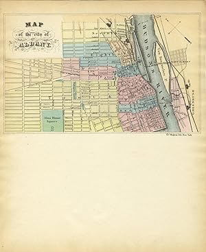
Map of the City of Albany New York.
Publicado por Sampson Murdock & Co.,, Albany:, 1892
Librería: Nicholas D. Riccio Rare Books, ABAA, Florham Park, NJ, Estados Unidos de America
Miembro de asociación: ABAA ILAB
Calificación del vendedor: 4 de 5 estrellas
EUR 44,37
Envío por EUR 6,89
Se envía dentro de Estados Unidos de AmericaCantidad disponible: 1 disponibles
Ańadir al carritoPartially colored map, 24" x 21 1/2", removed, narrow margins, reference box for public buildings. Paper fragile, some old tape repairs at folds, some more recent archival tape repairs at folds, some minor chips and tears in margins, one or two small holes, minor creasing, some splits still a bit open; despite faults in decent shape overall. This map is from The Albany Directory of 1892. The map attractively illustrates lakes, rivers, and public buildings in Albany at the close of the 19th century.
-
New York Albany Troy Rochester New York City 1859 Boynton miniature state map
Ańo de publicación: 1859
Librería: RareMapsandBooks, Dover, NH, Estados Unidos de America
Miembro de asociación: ESA IOBA
Calificación del vendedor: 5 de 5 estrellas
Mapa
EUR 28,84
Envío por EUR 5,99
Se envía dentro de Estados Unidos de AmericaCantidad disponible: 1 disponibles
Ańadir al carritoCondición: good. New York.(Old Maps, 19th Century Maps, Americana, United States, New York, Albany, Troy, Rochester, Buffalo, New York City). Issued 1859, Boston. Engraved by Boynton Mid 19th century miniature engraved map with original hand color. Map identifies area in square miles and state population. Well preserved, nice looking example with pleasing age patina. Sheet Measures c. 7 1/2" H x 5 1/2" W. Engraved Area Measures c. 6 1/4" H x 4 1/2" W. Cartographic Reference (s):Tooley's Dictionary of Mapmakers, vol. 1.[R32804].
-
MAP Of The CITY Of ALBANY
Publicado por Chs Magnus lith (n. d.), New York
Librería: Tavistock Books, ABAA, Reno, NV, Estados Unidos de America
Miembro de asociación: ABAA ESA ILAB IOBA
Calificación del vendedor: 5 de 5 estrellas
EUR 92,73
Envío por EUR 6,46
Se envía dentro de Estados Unidos de AmericaCantidad disponible: 3 disponibles
Ańadir al carritoCa mid-1850s. Bifolium, unused. Lithographed color map [4-3/4" x 8"] of Albany at top of sheet. 10-5/16" x 8-7/16" From an AAS record, we find: "From 1854 to 1857 and subsequently [post-1860], Charles Magnus is not listed as having a company but as an individual." Unused. Age-toning. Light edge-wear. A VG+ example. Now housed in an archival mylar sleeve.
-
[Darby's Tour, with one map] A tour from the city of New-York, to Detroit, in the Michigan Territory, made between the 2d of May and the 22d of September, 1818. : The tour extends from New-York, by Albany, Schenectady, and Utica, to Sacket's Harbor, and thence through Lake Ontario, to St. Lawrence River, and down that stream to Hamilton Village. : Thence along both banks of the St. Lawrence, from
Publicado por E. Worthington, 1819
Librería: Powell's Bookstores Chicago, ABAA, Chicago, IL, Estados Unidos de America
Miembro de asociación: ABAA ILAB
Calificación del vendedor: 5 de 5 estrellas
EUR 291,06
Envío por EUR 4,55
Se envía dentro de Estados Unidos de AmericaCantidad disponible: 1 disponibles
Ańadir al carritoHardcover. Condición: Used-Good. Published for the author, by Kirk & Mercein, and sold by Kirk & Mercein, A.T. Goodrich & Co. James Eastburn & Co. W.B. Gilley, Charles Wiley & Co. R. M'Dermut, Wiliam Hooker, and Collins & Co. New-York, and by some others of the principal booksellers in the United States. 1819. Printed by E. Worthington, Brooklyn. 228 pp. + 72 pp. Addendum. Of the three maps issued in this volume, one remains: the fold-out map of the Straits of Niagara. Foxing generally, but text and map still quite legible. Bound in three quarter calf over cloth boards, with contrasting leather title-lables on spine and front board. Spine edges worn; spine sunned. Other edges rubbed, but only a little worn. A sound copy, with 1 of 3 maps present. Howes D-66.
-
![Imagen del vendedor de Map of the City of Albany [New York, ca.1850]. a la venta por Wittenborn Art Books](https://pictures.abebooks.com/inventory/md/md9548450815.jpg)
Map of the City of Albany [New York, ca.1850].
Publicado por New York: Ch[arle]s. Magnus lith., [ca. 1850]., 1850
Librería: Wittenborn Art Books, San Francisco, CA, Estados Unidos de America
Calificación del vendedor: 5 de 5 estrellas
Manuscrito
EUR 88,74
Envío por EUR 8,62
Se envía dentro de Estados Unidos de AmericaCantidad disponible: 2 disponibles
Ańadir al carritoCondición: Good. Hand-colored lithographed map 13 x 20 cm (ca. 5 x 8 inches) on 4 page lettersheet, 26 x 21.5 cm (10.5 x 8.375 inches). Charles Magnus, [1826-1900], was a print publisher, map dealer, bookseller and stationer working in New York City from 1850 to 1899 who issued over a thousand different letter sheets, maps, song sheets, envelopes, and separate prints. Magnus was born Julian Carl Magnus in Elberfeld, Germany, and emigrated with his family to New York City between 1848 and 1850. Lettersheets were created to comply with, yet circumvent, postal regulations that based the price charged for mailing a letter on the number of sheets of paper. The lettersheets, measuring 8.5 x 21 inches, could be folded in half, providing four pages for writing but the Post Office regarded them as one sheet of paper. Illustrations, often bird's-eye views or detailed street scenes of cities, were printed in a rectangular space at the top of the first page of the folio to increase their commercial appeal.
-

Map of the City of Albany
Publicado por New York c. 1860, New York, 1860
Librería: High Ridge Books, Inc. - ABAA, South Deerfield, MA, Estados Unidos de America
Miembro de asociación: ABAA ESA ILAB SNEAB
Calificación del vendedor: 5 de 5 estrellas
EUR 110,92
Envío por EUR 7,84
Se envía dentro de Estados Unidos de AmericaCantidad disponible: 1 disponibles
Ańadir al carritoUnused lettersheet, fully colored, of the city of Albany on the west bank of the Hudson River and East Albany on the east bank. One sheet folded. Colored by ward. Milgram AL-LS-1: "A number of Magnus lettersheets exist with just a map view of a city. None of these has been seen in used condition by the author, but he suspects that these were printed before the Civil War, but were included in the other Magnus remainders found in this century. If one looks at the application of colors here, there is good reason to believe that the colors were applied through a stencil rather than freehand. This may be true of all of the Magnus hand-colored images. A matching city view in black may exist." It should be noted that the coloring on this example varies somewhat from that on the example illustrated in Milgrim's book, "American Illustrated Letter Stationery, 1819-1899", possibly challenging the conclusion that the coloring was strictly by stencil.
-
Map of the city of Albany
Librería: Zamboni & Huntington, Bangor, ME, Estados Unidos de America
Calificación del vendedor: 5 de 5 estrellas
EUR 66,55
Envío por EUR 8,40
Se envía dentro de Estados Unidos de AmericaCantidad disponible: 1 disponibles
Ańadir al carritoLetter sheet. Condición: Good. New York: Chs. Magnus, n.d. 10 3/8 x 8 3/8" (hand-colored image size: 4 7/8 x 7 7/8"). [4]pp. (single sheet, folded once). Light browning at edges, small smudge on map. Good copy. Letter sheet headed with a map of Albany, New York.
-

A tour from the City of New-York, to Detroit, in the Michigan Territory, made between the 2d of May and the 22d of September, 1818 : the tour extends from New-York, by Albany, Schenectady, and Utica to Sacket's Harbor, and thence throught Lake Ontario, to St. Lawrence river, and down that stream to Hamilton village. Thence along both banks of the St. Lawrence, from Hamilton to the Thousand Islands; thence to Sacket's Harbor by water; from that place by the route of great Sodus, Geneva, Cananaigua and Batavia, to Buffalo; and from thence to Black Rock, Fort Erie, the Falls of Niagara, Queenston, Lewiston, and the memorable fields of Bridgewater and Chippewa after viewing the interesting place of Niagara, the author traversed the south shore of Lake Erie to the City of Detroit, and visited in the latter range, Dunkirk, Erie, Cleveland, Sandusky, and other places of less note. The tour is accompanied with a map upon which the route will be designated; a particular map of the Falls andRive
Ańo de publicación: 2025
Librería: True World of Books, Delhi, India
Calificación del vendedor: 5 de 5 estrellas
EUR 27,50
Gastos de envío gratis
Se envía de India a Estados Unidos de AmericaCantidad disponible: 18 disponibles
Ańadir al carritoLeatherBound. Condición: New. BOOKS ARE EXEMPT FROM IMPORT DUTIES AND TARIFFS; NO EXTRA CHARGES APPLY. LeatherBound edition. Condition: New. Reprinted from 1819 edition. Leather Binding on Spine and Corners with Golden leaf printing on spine. NO changes have been made to the original text. This is NOT a retyped or an ocr'd reprint. Illustrations, Index, if any, are included in black and white. Each page is checked manually before printing. Pages: 326 As this print on demand book is reprinted from a very old book, there could be some missing or flawed pages, but we always try to make the book as complete as possible. Fold-outs, if any, are not part of the book. If the original book was published in multiple volumes then this reprint is of only one volume, not the whole set. Sewing binding for longer life, where the book block is actually sewn (smythe sewn/section sewn) with thread before binding which results in a more durable type of binding. Pages: 326 Language: English.
-

Map of the city of Albany, New York
Ańo de publicación: 1855
Librería: Art Source International Inc., Boulder, CO, Estados Unidos de America
Calificación del vendedor: 5 de 5 estrellas
EUR 88,74
Envío por EUR 13,78
Se envía dentro de Estados Unidos de AmericaCantidad disponible: 2 disponibles
Ańadir al carritoThis vibrant map of Albany, New York was created by Charles Magnus. Charles Magnus was a print publisher in New York City from 1850 to 1899. He is best known for his city views and Civil War related material. This map measures 8 inches by 5 inches.


