Importe total (1 artículo artículos):
Destino del pedido:

manuscript document early true copy (1 resultados)
Comentarios
Ir a los resultados principales
Filtros de búsqueda
Tipo de artículo
- Todos los tipos de productos
- Libros (1)
- Revistas y publicaciones (No hay ningún otro resultado que coincida con este filtro.)
- Cómics (No hay ningún otro resultado que coincida con este filtro.)
- Partituras (No hay ningún otro resultado que coincida con este filtro.)
- Arte, grabados y pósters (No hay ningún otro resultado que coincida con este filtro.)
- Fotografías (No hay ningún otro resultado que coincida con este filtro.)
- Mapas (No hay ningún otro resultado que coincida con este filtro.)
- Manuscritos y coleccionismo de papel (No hay ningún otro resultado que coincida con este filtro.)
Condición
- Todos los libros
- Nuevos (No hay ningún otro resultado que coincida con este filtro.)
- Antiguos o usados (1)
Encuadernación
- Todas
- Tapa dura (No hay ningún otro resultado que coincida con este filtro.)
- Tapa blanda (No hay ningún otro resultado que coincida con este filtro.)
Más atributos
- Primera edición (No hay ningún otro resultado que coincida con este filtro.)
- Firmado (1)
- Sobrecubierta (No hay ningún otro resultado que coincida con este filtro.)
- Con imágenes (1)
- No impresión bajo demanda (1)
Idioma (1)
Precio
- Cualquier precio
- Menos de EUR 20 (No hay ningún otro resultado que coincida con este filtro.)
- EUR 20 a EUR 45 (No hay ningún otro resultado que coincida con este filtro.)
- Más de EUR 45
Gastos de envío gratis
- Envío gratis a Espańa (No hay ningún otro resultado que coincida con este filtro.)
Ubicación del vendedor
Valoración de los vendedores
-
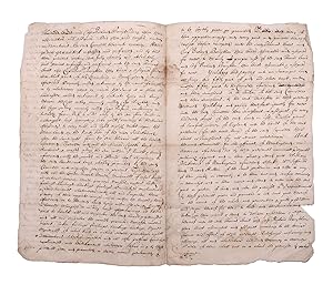
Manuscript document, early true copy of the grant by the Council of New England to Thomas Lewis and Richard Bonighton of the land on the north side of the Saco River
Publicado por [Likely Boston], 1680
Librería: James Cummins Bookseller, ABAA, New York, NY, Estados Unidos de America
Miembro de asociación: ABAA ILAB
Calificación del vendedor: 5 de 5 estrellas

Ejemplar firmado
EUR 5.896,97
Convertir monedaEUR 39,64 gastos de envío desde Estados Unidos de America a EspańaCantidad disponible: 1 disponibles
Ańadir al carrito4pp. Clerically signed Robert Warwick and Edward Gorges above an additional reaffirmation of grant dated June 1631, clerically countersigned by Thomas Wiggin, James Parker, James Watts, and George Donglan. Docketed "Patent Saco: east of the river". Bifolium. In 1629, less than a decade after the Pilgrims landed at Plymouth Rock, the Council of New England, an English joint stock company founded to establish colonial settlements in America, issued a series of grants subdividing their royal charter that had ceded to them all land between "degrees 34 and 44," from sea to sea. These grants were important, being among the earliest grants independently issued within the colonies. The present grant is of particular note for the history of Maine, being the grant made to Thomas Lewis and Captain Richard Bonython for the land north of the Swanckadocke River, i.e. the Saco River. The text of the grant reads (in part): ".Whereas King James of famous memory, late King of England, Scotland, France, and Ireland, by his Highness' letters patent and royal grant under the great seal of England, bearing date the third day of November in the eighteenth year of his reign of England, France, and Ireland, etc., for the causes therein expressed did absolutely give, grant, and confirm to the said Council for the affairs of New England in America, and their successors forever, all the land of New England lying and being from forty to forty-eight degrees of northerly latitude and in length by all that breadth aforesaid from sea to sea throughout the main land . that the said council for the affairs of New England in America, as well for and in consideration that Thomas Lewis, Gentleman, has already been at the charge to transport himself and others to take a view of New England in America aforesaid for the bettering of his experience in advancing of a plantation, and does now wholly intend by God's assistance with his associates to plant there, both for the good of his Majesty's realms and dominions and for the propagation of Christian religion among those infidels, and in consideration also that the said Thomas Lewis together with Captain Richard Bonighton, and also with their associates and company, have undertaken at their own proper costs and charges to transport fifty persons there within seven years next ensuing to plant and inhabit there to the advancement of the general plantation of that country and the strength and safety thereof among the natives or any other invaders, also for the encouragement of the said Thomas Lewis and Captain Richard Bonighton, and other considerations the said council thereunto moving, have given, granted, enfeoffed, and confirmed, and by this present writing do fully, clearly, and absolutely give, grant, enfeof, and confirm to the said Thomas Lewis and Captain Richard Bonighton, their heirs and assigns for ever, all that part of the main land in New England in America, aforesaid, commonly called or known by the name of Swanckadocke, or by whatsoever other name or names the same is or shall be hereafter called or known by, situated, lying, and being between the cape or bay commonly called Cape Elizabeth and the cape or bay commonly called Cape Porpoise, containing in breadth from northeast to southwest along by the sea four miles in a straight line, or accounting seventeen hundred and three score yards according to the standard of England to every mile, and eight English miles upon the main land on the north side of the river Swanckadock after the same rate, from the sea through all the breadth aforesaid ." The original vellum grant with seals is located in the archives of the Maine Historical Society. The present example is one of several extant early manuscript copies made during the subsequent conflicts and competing claims between the crown, Massachusetts and Maine. In 1652, commissioners were appointed to determine the correct boundary between Massachusetts and several of the early patents, with the former gradually extending their claim northward. In 1653 the settlers of Saco and other parts of Maine yielded to Massachusetts and the region was renamed Yorkshire, or County of York. In 1664, after the Restoration, the region was restored as an independent province, but much of the region sold back to Massachusetts in 1678. After the charter of Massachusetts was annulled in 1684 and James II ascended to the crown in 1685, the region was once again assigned as part of the Province of Massachusetts Bay. Maine would remain part of Massachusetts until the final separation in 1820. The present undated copy likely dates from the period circa 1664 when a royal commission consisting of Richard Nicolls, Sir Robert Carre, George Cartwright and Samuel Maverick was sent to oversee the government of the colonies in New England. However, it could also date as late as the period from the 1680s when Sir Edmund Andros became the Commissioner for the Dominion of New England. Documentary History of the State of Maine, vol. 7, p. 117 Usual folds, minor separations, two repaired 4pp. Clerically signed Robert Warwick and Edward Gorges above an additional reaffirmation of grant dated June 1631, clerically countersigned by Thomas Wiggin, James Parker, James Watts, and George Donglan. Docketed "Patent Saco: east of the river". Bifolium.