
Importe total (1 artĒculo artĒculos):
Destino del pedido:

key west harbor approaches (7 resultados)
Ir a los resultados principales
Filtros de b·squeda
Tipo de artĒculo
- Todos los tipos de productos
- Libros (5)
- Revistas y publicaciones (No hay ning·n otro resultado que coincida con este filtro.)
- C¾mics (No hay ning·n otro resultado que coincida con este filtro.)
- Partituras (No hay ning·n otro resultado que coincida con este filtro.)
- Arte, grabados y p¾sters (No hay ning·n otro resultado que coincida con este filtro.)
- FotografĒas (No hay ning·n otro resultado que coincida con este filtro.)
- Mapas (2)
- Manuscritos y coleccionismo de papel (No hay ning·n otro resultado que coincida con este filtro.)
Condici¾n Mßs informaci¾n
- Nuevo (No hay ning·n otro resultado que coincida con este filtro.)
- Como nuevo, Excelente o Muy bueno (No hay ning·n otro resultado que coincida con este filtro.)
- Bueno o Aceptable (2)
- Regular o Pobre (No hay ning·n otro resultado que coincida con este filtro.)
- Tal como se indica (5)
Encuadernaci¾n
- Todas
- Tapa dura (No hay ning·n otro resultado que coincida con este filtro.)
- Tapa blanda (No hay ning·n otro resultado que coincida con este filtro.)
Mßs atributos
- Primera edici¾n (No hay ning·n otro resultado que coincida con este filtro.)
- Firmado (No hay ning·n otro resultado que coincida con este filtro.)
- Sobrecubierta (No hay ning·n otro resultado que coincida con este filtro.)
- Con imßgenes (6)
- No impresi¾n bajo demanda (7)
Idioma (1)
Precio
- Cualquier precio
- Menos de EUR 20 (No hay ning·n otro resultado que coincida con este filtro.)
- EUR 20 a EUR 40 (No hay ning·n otro resultado que coincida con este filtro.)
- Mßs de EUR 40
Gastos de envĒo gratis
- EnvĒo gratis a Estados Unidos de America (No hay ning·n otro resultado que coincida con este filtro.)
Ubicaci¾n del vendedor
Valoraci¾n de los vendedores
-

US Coast Survey Preliminary Chart of Florida Reefs Showing the Approaches to Key West Harbor, 1857
A±o de publicaci¾n: 1857
Librería: Art Source International Inc., Boulder, CO, Estados Unidos de America
Calificaci¾n del vendedor: 5 de 5 estrellas

EUR 56,72
EnvĒo por EUR 13,56
Se envĒa dentro de Estados Unidos de AmericaCantidad disponible: 3 disponibles
A±adir al carritoThis black and white, antique coastal survey was made for the United States Coast Survey. The surveys provide depth readings and notes on important coastal characteristics of the area mapped. The names of harbors, rivers, islands, channels, shoals, capes, inlets, and coastal towns are identified on the map. These charts show areas that have likely undergone significant changes due to modifications and recessions of coastal lands, making them fascinating to anyone interested in local geography and history. This map details the Florida Keys, including Key West. This map measure 22 inches by 18 inches.
-

U.S. Coast Survey Showing Preliminary Chart of Key West harbor and Approaches
A±o de publicaci¾n: 1852
Librería: Art Source International Inc., Boulder, CO, Estados Unidos de America
Calificaci¾n del vendedor: 5 de 5 estrellas
EUR 65,45
EnvĒo por EUR 13,56
Se envĒa dentro de Estados Unidos de AmericaCantidad disponible: 3 disponibles
A±adir al carritoThis black and white, antique coastal survey was made for the United States Coast Survey. The surveys provide depth readings and notes on important coastal characteristics of the area mapped. The names of harbors, rivers, islands, channels, shoals, capes, inlets, and coastal towns are identified on the map. These charts show areas that have likely undergone significant changes due to modifications and recessions of coastal lands, making them fascinating to anyone interested in local geography and history.This map shows Key West harbor and Approaches. Map includes depth readings and over all great detail.Sold folded as issued. This map measure 17 inches by 14.5 inches.
-

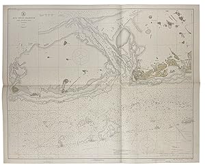
U.S. Coast Survey Prelininary Chart of Key West Harbor and Approaches
A±o de publicaci¾n: 1851
Librería: Art Source International Inc., Boulder, CO, Estados Unidos de America
Calificaci¾n del vendedor: 5 de 5 estrellas
EUR 65,45
EnvĒo por EUR 13,56
Se envĒa dentro de Estados Unidos de AmericaCantidad disponible: 1 disponibles
A±adir al carritoThis black and white, antique coastal survey was made for the United States Coast Survey. The surveys provide depth readings and notes on important coastal characteristics of the area mapped. The names of harbors, rivers, islands, light houses, channels, shoals, capes, inlets, and coastal towns are identified on the map. These charts show areas that have likely undergone significant changes due to modifications and recessions of coastal lands, making them fascinating to anyone interested in local geography and history. This map of Key West shows great detail. Note: Age toning around the folds in these maps is quite common. Map is sold folded as issued. This map measure 17 inches by 14.5 inches.
-

United States - East Coast, Key West Harbor and Approaches, Florida
A±o de publicaci¾n: 1972
Librería: Art Source International Inc., Boulder, CO, Estados Unidos de America
Calificaci¾n del vendedor: 5 de 5 estrellas
EUR 65,45
EnvĒo por EUR 13,56
Se envĒa dentro de Estados Unidos de AmericaCantidad disponible: 1 disponibles
A±adir al carritoThis coastal survey was printed by the U.S. Navy Hydrographic Office in Washington D.C. Details include the names of cities and waterways along the coast. Depth soundings are shown in fathoms. Other details that maybe included are lighthouses and buoy positions. This map measure 42.5 inches by 34 inches.
-

(Sketch F No. 5) Preliminary Chart of Key-West Harbor and Approaches
Publicado por U.S. Coast Survey c. 1851, United States, 1851
Librería: Alexandre Antique Prints, Maps & Books, Toronto, ON, Canada
Miembro de asociaci¾n: ABAC ILAB
Calificaci¾n del vendedor: 5 de 5 estrellas
Mapa
EUR 414,52
EnvĒo por EUR 5,08
Se envĒa de Canada a Estados Unidos de AmericaCantidad disponible: 1 disponibles
A±adir al carritoCondici¾n: Very Good; Size : 365x432 (mm), 14.37x17.01 (Inches), Hand Colored in Outline.
-
Key West Harbor and Approaches
Publicado por Published by the United States Coast and Geodetic Survey, Washington D.C., 1922
Librería: Donald A. Heald Rare Books (ABAA), New York, NY, Estados Unidos de America
Miembro de asociaci¾n: ABAA ILAB
Calificaci¾n del vendedor: 5 de 5 estrellas
Mapa
EUR 1.745,34
EnvĒo por EUR 21,18
Se envĒa dentro de Estados Unidos de AmericaCantidad disponible: 1 disponibles
A±adir al carritoLarge folding nautical chart, printed on heavy paper stock. Colored. A rare original coastal survey of Key West Harbor. Established by President Thomas Jefferson in 1807 as the Survey of the Coast, the U.S. Coast and Geodetic Survey was the United States' first civilian scientific agency. This agency has followed its mission to survey the U.S. coastline, create nautical charts of the coast, and help increase maritime safety since its founding, and has often played fascinating roles in significant chapters of U.S. history. It served in all theaters of the Civil War in the service of the Union Army and Navy, pioneered acoustic exploration in the wake of the sinking of the Titanic, and during WWI it worked to detect enemy submarines. In addition, this agency worked to survey and produce detailed maps and renderings of the U.S. coast. These nautical survey maps (commonly referred to as "T-sheets") provide fascinating insights into the history of the United States coastline, which has and will continue to shift. These maps are the most important data source for understanding the physical and ecological characteristics of the U.S. shoreline. The present map of the Florida coastline is notable in displaying the Overseas Railroad as the only main land transportation link between the Keys. At the time this map was published, the overseas highway had yet to be built and tourism and travel in the region was limited to boat or train. This map is a highly detailed and accurate sea chart of Key West, and an important historical view of a developing Florida.
-

Key West Harbor and Approaches - Postwar nautical chart of Key West, Florida.
A±o de publicaci¾n: 1948
Librería: Curtis Wright Maps, Berwyn, IL, Estados Unidos de America
Miembro de asociaci¾n: ESA MWABA
Calificaci¾n del vendedor: 4 de 5 estrellas

EUR 109,08
EnvĒo por EUR 10,17
Se envĒa dentro de Estados Unidos de AmericaCantidad disponible: 1 disponibles
A±adir al carritoCondici¾n: Very Good. This detailed navigational chart of the approaches to Key West, Florida was originally created by the United States Coast and Geodetic Survey in 1940. A rubber stamp in the lower right indicates this example has published updates through April 1948. Depth soundings are noted throughout the image, which also labels various locations of interest and geographic features. Of particular interest are the large regions labeled Submarine Exercise Area. Text in the lower center encourages vessels to proceed with caution. Sheet Width (in) 43.25 Sheet Height (in) 35.25 Condition Description Several spots of staining visible in the upper and lower center of the sheet (see scan), with additional soiling near the title in the upper left. Printed on thick paper that shows moderate creasing along old fold lines. Between fair and good condition overall.
