
Importe total (1 artículo artículos):
Destino del pedido:

illinois state county map chicago (6 resultados)
Ir a los resultados principales
Filtros de búsqueda
Tipo de artículo
- Todos los tipos de productos
- Libros (2)
- Revistas y publicaciones (No hay ningún otro resultado que coincida con este filtro.)
- Cómics (No hay ningún otro resultado que coincida con este filtro.)
- Partituras (No hay ningún otro resultado que coincida con este filtro.)
- Arte, grabados y pósters (No hay ningún otro resultado que coincida con este filtro.)
- Fotografías (No hay ningún otro resultado que coincida con este filtro.)
- Mapas (4)
- Manuscritos y coleccionismo de papel (No hay ningún otro resultado que coincida con este filtro.)
Condición Más información
- Nuevo (2)
- Como nuevo, Excelente o Muy bueno (No hay ningún otro resultado que coincida con este filtro.)
- Bueno o Aceptable (3)
- Regular o Pobre (No hay ningún otro resultado que coincida con este filtro.)
- Tal como se indica (1)
Encuadernación
- Todas
- Tapa dura (2)
- Tapa blanda (No hay ningún otro resultado que coincida con este filtro.)
Más atributos
- Primera edición (No hay ningún otro resultado que coincida con este filtro.)
- Firmado (No hay ningún otro resultado que coincida con este filtro.)
- Sobrecubierta (No hay ningún otro resultado que coincida con este filtro.)
- Con imágenes (6)
- No impresión bajo demanda (4)
Idioma (2)
Precio
- Cualquier precio
- Menos de EUR 20 (No hay ningún otro resultado que coincida con este filtro.)
- EUR 20 a EUR 45
- Más de EUR 45
Gastos de envío gratis
Ubicación del vendedor
Valoración de los vendedores
-
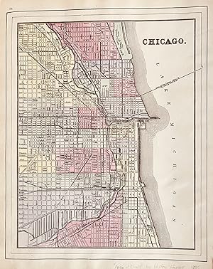
Illinois State Cook County Chicago Springfield c. 1880's-90 Cram large map
Ańo de publicación: 1880
Librería: RareMapsandBooks, Dover, NH, Estados Unidos de America
Miembro de asociación: ESA IOBA
Calificación del vendedor: 5 de 5 estrellas

Mapa
EUR 24,38
Envío por EUR 5,98
Se envía dentro de Estados Unidos de AmericaCantidad disponible: 1 disponibles
Ańadir al carritoCondición: good. Illinois.(Old Maps, 19th Century Maps, North America, United States, Midwest, Illinois, Cook County, Chicago, Springfield, East St. Louis). Issued c. 1880's-90, United States, by likely Cram. Late 19th century color lithographed map. A very large, oversized map, not to be confused with the smaller, much more common Cram maps of this period. This map version appeared only briefly and is note worthy for the level of detail. Well preserved, nice looking example with pleasing age patina. Original center fold as issued. Sheet Measures c. 17 3/4" H x 25" W. Printed Area Measures c. 16 1/4" H x 22" W.[R28197].
-
Illinois State County Map Chicago Springfield 1881 Mitchell map
Ańo de publicación: 1881
Librería: RareMapsandBooks, Dover, NH, Estados Unidos de America
Miembro de asociación: ESA IOBA
Calificación del vendedor: 5 de 5 estrellas
Mapa
EUR 28,82
Envío por EUR 5,98
Se envía dentro de Estados Unidos de AmericaCantidad disponible: 1 disponibles
Ańadir al carritoCondición: good. County and Township Map of the State of Illinois.(Old Maps, 19th Century Maps, Americana, United States, Midwest, Illinois, Chicago, Springfield). Issued 1881, Philadelphia by S. A. Mitchell. Fine 19th century engraved (lithographed) map, with original hand color. Mitchell maps of this mid-century era were issued with a range of variant decorative borders. Attractive example, pleasing age patina, overall clean, any minor age flaws easy to overlook or forgive. Original center fold as issued. Sheet Measures c. 15 1/4" H x 25" W. Engraved Area Measures c. 13 3/4" H x 22" W. Cartographic Reference (s):Reps, American Maps and Mapmakers, p. 313. Tooley's Dictionary of Mapmakers, vol. 4, pp. 260.[R28662].
-

County Map of the State of Illinois with inset Plan of Chicago
Publicado por Mitchell, S. Augustus, Philadelphia, 1867
Librería: mediumraremaps.com, Franklin, TN, Estados Unidos de America
Calificación del vendedor: 4 de 5 estrellas

Mapa
EUR 57,63
Envío por EUR 5,16
Se envía dentro de Estados Unidos de AmericaCantidad disponible: 1 disponibles
Ańadir al carrito10 3/4 x 13 1/4 inches. Condición: Very Good. Mitchell, S. A. Ilustrador. This is a superbly colored map of Illinois and its counties designated with the use of two colors and no color for the third designator. The inset plan of Chicago is also designated with color by ward. Taken from an 1867 edition of Mitchells General Atlas it would look excellent framed an on the wall!
-
![Imagen del vendedor de Map report / prepared by Bruce H. Wegener. [Sponsored by State of Illinois, Cook County, and the City of Chicago, in cooperation with U.S. Bureau of Public Roads] 1958 [LeatherBound] a la venta por S N Books World](https://pictures.abebooks.com/inventory/md/md32213533031.jpg)
Map report / prepared by Bruce H. Wegener. [Sponsored by State of Illinois, Cook County, and the City of Chicago, in cooperation with U.S. Bureau of Public Roads] 1958 [LeatherBound]
Idioma: Inglés
Ańo de publicación: 2025
Librería: S N Books World, Delhi, India
Calificación del vendedor: 5 de 5 estrellas
EUR 26,59
Gastos de envío gratis
Se envía de India a Estados Unidos de AmericaCantidad disponible: 18 disponibles
Ańadir al carritoLeatheBound. Condición: New. BOOKS ARE EXEMPT FROM IMPORT DUTIES AND TARIFFS; NO EXTRA CHARGES APPLY. Leatherbound edition. Condition: New. Leather Binding on Spine and Corners with Golden leaf printing on spine. Bound in genuine leather with Satin ribbon page markers and Spine with raised gilt bands. Pages: 88. A perfect gift for your loved ones. Reprinted from 1958 edition. NO changes have been made to the original text. This is NOT a retyped or an ocr'd reprint. Illustrations, Index, if any, are included in black and white. Each page is checked manually before printing. As this print on demand book is reprinted from a very old book, there could be some missing or flawed pages, but we always try to make the book as complete as possible. Fold-outs, if any, are not part of the book. If the original book was published in multiple volumes then this reprint is of only one volume, not the whole set. IF YOU WISH TO ORDER PARTICULAR VOLUME OR ALL THE VOLUMES YOU CAN CONTACT US. Resized as per current standards. Sewing binding for longer life, where the book block is actually sewn (smythe sewn/section sewn) with thread before binding which results in a more durable type of binding. Language: English Pages: 88.
-
![Imagen del vendedor de Map report / prepared by Bruce H. Wegener. [Sponsored by State of Illinois, Cook County, and the City of Chicago, in cooperation with U.S. Bureau of Public Roads] 1958 [LeatherBound] a la venta por S N Books World](https://pictures.abebooks.com/inventory/md/md30962537150.jpg)
Map report / prepared by Bruce H. Wegener. [Sponsored by State of Illinois, Cook County, and the City of Chicago, in cooperation with U.S. Bureau of Public Roads] 1958 [LeatherBound]
Idioma: Inglés
Ańo de publicación: 2025
Librería: S N Books World, Delhi, India
Calificación del vendedor: 5 de 5 estrellas
EUR 26,59
Gastos de envío gratis
Se envía de India a Estados Unidos de AmericaCantidad disponible: 18 disponibles
Ańadir al carritoLeatherBound. Condición: New. BOOKS ARE EXEMPT FROM IMPORT DUTIES AND TARIFFS; NO EXTRA CHARGES APPLY. Leatherbound edition. Condition: New. Leather Binding on Spine and Corners with Golden leaf printing on spine. Bound in genuine leather with Satin ribbon page markers and Spine with raised gilt bands. Pages: 80. A perfect gift for your loved ones. Reprinted from 1958 edition. NO changes have been made to the original text. This is NOT a retyped or an ocr'd reprint. Illustrations, Index, if any, are included in black and white. Each page is checked manually before printing. As this print on demand book is reprinted from a very old book, there could be some missing or flawed pages, but we always try to make the book as complete as possible. Fold-outs, if any, are not part of the book. If the original book was published in multiple volumes then this reprint is of only one volume, not the whole set. IF YOU WISH TO ORDER PARTICULAR VOLUME OR ALL THE VOLUMES YOU CAN CONTACT US. Resized as per current standards. Sewing binding for longer life, where the book block is actually sewn (smythe sewn/section sewn) with thread before binding which results in a more durable type of binding. Language: English Pages: 80.
-
Chicago St Louis with a double page mat of Illinois on the verso. County & Township Map of the State of Illinois
Publicado por Hilton & Hughes in Atlas of the World, New York, 1885
Librería: mediumraremaps.com, Franklin, TN, Estados Unidos de America
Calificación del vendedor: 4 de 5 estrellas
Mapa
EUR 221,64
Envío por EUR 5,16
Se envía dentro de Estados Unidos de AmericaCantidad disponible: 1 disponibles
Ańadir al carrito1885 Edition. This map was printed in color and came from an atlas most likely produced by the Bradley Firm that was successor to the Mitchell firm. Further it was apparently published for the firm of Hilton and Hughes whom are listed on the title page as publisher. The map of Chicago and also of St. Louis are pure Mitchell. The map of Illinois is a superb rarecord of the contemporary railroad networks. The map of Illinois is difficult to find in the marketplace and is from a rare late 19th century atlas. Very Good condition with several small tears repaired with archival mending tape Chicago, 10 3/4 x 13 1/2 : St. Louis, 10 3/4 x 14 1/2; Illinois, 14 x 20, with inset of Chicago and Vicinity of 8 1/2 x 6.

