
Importe total (1 artículo artículos):
Destino del pedido:

general chart mercators projection (7 resultados)
Ir a los resultados principales
Filtros de búsqueda
Tipo de artículo
- Todos los tipos de productos
- Libros (3)
- Revistas y publicaciones (No hay ningún otro resultado que coincida con este filtro.)
- Cómics (No hay ningún otro resultado que coincida con este filtro.)
- Partituras (No hay ningún otro resultado que coincida con este filtro.)
- Arte, grabados y pósters (1)
- Fotografías (No hay ningún otro resultado que coincida con este filtro.)
- Mapas (3)
- Manuscritos y coleccionismo de papel (No hay ningún otro resultado que coincida con este filtro.)
Condición Más información
- Nuevo (No hay ningún otro resultado que coincida con este filtro.)
- Como nuevo, Excelente o Muy bueno (1)
- Bueno o Aceptable (2)
- Regular o Pobre (No hay ningún otro resultado que coincida con este filtro.)
- Tal como se indica (4)
Encuadernación
- Todas
- Tapa dura (1)
- Tapa blanda (No hay ningún otro resultado que coincida con este filtro.)
Más atributos
- Primera edición (No hay ningún otro resultado que coincida con este filtro.)
- Firmado (No hay ningún otro resultado que coincida con este filtro.)
- Sobrecubierta (No hay ningún otro resultado que coincida con este filtro.)
- Con imágenes (7)
- No impresión bajo demanda (7)
Idioma (2)
Precio
- Cualquier precio
- Menos de EUR 20 (No hay ningún otro resultado que coincida con este filtro.)
- EUR 20 a EUR 45 (No hay ningún otro resultado que coincida con este filtro.)
- Más de EUR 45
Gastos de envío gratis
- Envío gratis a Estados Unidos de America (No hay ningún otro resultado que coincida con este filtro.)
Ubicación del vendedor
Valoración de los vendedores
-
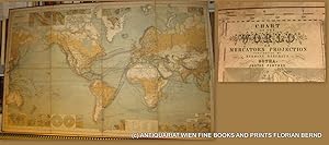
WORLD MAP- 1879 // Chart of the world on Mercators projection : containing the lines of oceanic mail steam communication and overland routes, the international aerial and submarine telegraphs, and the principal tracks of sailing vessels, showing some continental surface characteristics, the oceanic currents and important deep-sea soundings, with 33 additional charts and plans showing the general currents of air, and the lines of equal magnetic variation, the Tehuantepec, Honduras, Nicaragua, Panama, Darien, and Suez routes, several sea ports, the telegraphic and steam lines round the world = Chart of the world zur Übersicht der regelmässigen Dampfschifffahrts-Linien und Überland-Routen, der internationalen Land- und Untersee-Telegraphen, sowie der wichtigeren Segelschiffswege, der Bodenbeschaffenheit, der See-Strömungen und neuerer Tiefsee-Messungen, mit 33 Nebenkarten zur Darstellung der Haupt-Windrichtungen und der Linien gleicher magnetischer Missweisung, der Landengen von Tehuantep
Publicado por Perthes, Gotha, 1879
Librería: ANTIQUARIAT.WIEN Fine Books & Prints, Wien, Austria
Miembro de asociación: ILAB VDAO
Calificación del vendedor: 5 de 5 estrellas

Mapa
EUR 1.380,50
Envío por EUR 72,00
Se envía de Austria a Estados Unidos de AmericaCantidad disponible: 1 disponibles
Ańadir al carrito9th edition, original Lithograph / 9. Auflage original Lithographie zu 8 Segmenten auf Leinen gezogen, Gesamtformat ca. 155 x 97 cm; Zustand: gut Weltkarte von Hermann Beghaus (1828-1890) Neffe und Schüler von Heinrich Berghaus. Nephew and pupil of Heinrich Berghaus; und Friedrich v. Stülpnagel (1786-1865) Tooley I, 125, IV, 231 de 350 Landkarte.
-

General Chart on Mercators Projection
Publicado por New York c.1805, New York, 1805
Librería: High Ridge Books, Inc. - ABAA, South Deerfield, MA, Estados Unidos de America
Miembro de asociación: ABAA ESA ILAB SNEAB
Calificación del vendedor: 5 de 5 estrellas
EUR 132,98
Envío por EUR 7,83
Se envía dentro de Estados Unidos de AmericaCantidad disponible: 1 disponibles
Ańadir al carritoUncolored map of the world published for the New Encyclopedia. fine condition with typical very light soiling and wear. This was a later issue of a map first included in John Payne's New and Complete Universal Geography in 1798. The features and place names are very similar to, with a handful of additions, those used on Morse's Chart of the World from his 1796 Universal Geography. The most prevalent additions are the tracks of explorers, most notably Cook. These include a line at Hawaii (Owhyhee) noting Cook's death there. Engraved by Rollinson. See Wheat & Brun 39 for the earlier issue.
-

Hydrographical Chart Of The World On Wright Or Mercators Projection With Tracks Of The Last Circumnavigators From 'A New General Atlas, consisting of A Series of Geographical Designs, on Various Projections, Exhibiting the Form and Component Parts of the Globe; and A Collection of Maps and Charts, Delineating the Natural and Political Divisions of the Empires, Kingdoms and States of the World'.
Publicado por John Thomson & Company, Edinburgh, UK, 1814
Librería: Hornseys, Ripon, Reino Unido
Miembro de asociación: PBFA
Calificación del vendedor: 5 de 5 estrellas
EUR 351,29
Envío por EUR 28,90
Se envía de Reino Unido a Estados Unidos de AmericaCantidad disponible: 1 disponibles
Ańadir al carritoNo Binding. Condición: Very Good. Sheet size: 68cm x 53.8cm. From 'A New General Atlas, consisting of A Series of Geographical Designs, on Various Projections, Exhibiting the Form and Component Parts of the Globe; and A Collection of Maps and Charts, Delineating the Natural and Political Divisions of the Empires, Kingdoms and States of the World'. Date c.1814-1816. Crease to central fold line with a short split to the margin. Blank to the reverse. Age-toning, especially to the margins, minor off-setting and slight foxing as usual. Original hand-colouring nice and bright. In very good, bright, clean condition. This is one of a number of these maps that e are currently posting. Please see our other listings or use the keyword: hornseysthomson.
-

General Chart on Mercators Projection. World. Cook's route.
Idioma: Alemán
Ańo de publicación: 1798
Librería: Antiquariat im Schloss, Schwaigern, D, Alemania
Calificación del vendedor: 5 de 5 estrellas
EUR 70,00
Envío por EUR 35,00
Se envía de Alemania a Estados Unidos de AmericaCantidad disponible: 1 disponibles
Ańadir al carrito1 Blatt, 26,5 x 21 cm. Antique copperplate engraved map with original hand colouring. Kupferstichkarte mit originaler Handkolorierung. Ränder mit 2 kleinen Fehlstücken, Karte ohne Bildverlust. Sprache: Deutsch Gewicht in Gramm: 900.
-
1797 A GENERAL CHART OF THE WORLD ON MERCATOR'S PROJECTION, EXHIBITING ALL THE NEW DISCOVERIES AND THE TRACKS OF THE DIFFERENT CIRCUM-NAVIGATORS.
Ańo de publicación: 1797
Librería: Sage Rare & Collectible Books, IOBA, Livonia, MI, Estados Unidos de America
Miembro de asociación: IOBA
Calificación del vendedor: 5 de 5 estrellas
Mapa
EUR 678,22
Envío por EUR 5,59
Se envía dentro de Estados Unidos de AmericaCantidad disponible: 1 disponibles
Ańadir al carritoMap. Condición: Very Good. Title: 1797 A General Chart of the World on Mercator's Projection, exhibiting all the New Discoveries and the Tracks of the different Circum-Navigators. Condition: This original 1835 copper plate map is lightly toned with folds as issued with a chip to the upper left corner that cuts into the outer margin but overall in very good condition. It is tipped onto a mounting board with very clean matting ready to frame. Dimensions: 18" x 14" (including margins) with 23" x 19 matte. Details: This copper plate engraved map by John Norman was published in the Boston edition of Malham'sNaval Gazetteer tracking the 3 major voyages of Captain Cook from 1768 to 1780.
-

A General Chart, on Mercator's Projection, to shew the track of the Lion and Hindostan from England to the Gulph of Pekin in China, and of their return to England .
Ańo de publicación: 1796
Librería: Maggs Bros. Ltd ABA, ILAB, PBFA, London, Reino Unido
Miembro de asociación: ABA ILAB PBFA
Calificación del vendedor: 5 de 5 estrellas
Arte / Grabado / Póster
EUR 1.786,23
Envío por EUR 31,22
Se envía de Reino Unido a Estados Unidos de AmericaCantidad disponible: 1 disponibles
Ańadir al carritoCopperplate engraving, 590 x 935 mm, evidence of old folds. London, 12th April, Map of Europe, Asia and part of Brazil showing the routes taken on Lord Macartney's voyages to and from China, 1792-94, from a volume of plates to George Staunton, An Authentic Account of an Embassy from the King of Great Britain to the Emperor of China, 1797.
-

A General Chart on Mercator's Projection,
Publicado por London, 1796
Librería: Tmecca Inc., Seoul, Republica de Corea
Miembro de asociación: ILAB
Calificación del vendedor: 2 de 5 estrellas

Mapa
EUR 620,59
Envío por EUR 17,21
Se envía de Republica de Corea a Estados Unidos de AmericaCantidad disponible: 1 disponibles
Ańadir al carritoNo Binding. Condición: As New. 60 x 93 cm. Large chart issued in the atlas volume of the official account by George Staunton of George Macartney's travels to China. Macartney was Britain's first envoy to China, tasked with convincing Emperor Qianlong to ease restrictions on trade between Great Britain and China. The map shows the track of two ships, the Lion and Hindostan, on their routes from England to China and back. Each day's progress was recorded along the route along with several notations to the dangers along the way.
