
Importe total (1 artículo artículos):
Destino del pedido:

france de dower (7 resultados)
Ir a los resultados principales
Filtros de búsqueda
Tipo de artículo
- Todos los tipos de productos
- Libros (4)
- Revistas y publicaciones (No hay ningún otro resultado que coincida con este filtro.)
- Cómics (No hay ningún otro resultado que coincida con este filtro.)
- Partituras (No hay ningún otro resultado que coincida con este filtro.)
- Arte, grabados y pósters (No hay ningún otro resultado que coincida con este filtro.)
- Fotografías (No hay ningún otro resultado que coincida con este filtro.)
- Mapas (2)
- Manuscritos y coleccionismo de papel (1)
Condición Más información
- Nuevo (No hay ningún otro resultado que coincida con este filtro.)
- Como nuevo, Excelente o Muy bueno (No hay ningún otro resultado que coincida con este filtro.)
- Bueno o Aceptable (3)
- Regular o Pobre (No hay ningún otro resultado que coincida con este filtro.)
- Tal como se indica (4)
Encuadernación
- Todas
- Tapa dura (No hay ningún otro resultado que coincida con este filtro.)
- Tapa blanda (2)
Más atributos
- Primera edición (No hay ningún otro resultado que coincida con este filtro.)
- Firmado (No hay ningún otro resultado que coincida con este filtro.)
- Sobrecubierta (No hay ningún otro resultado que coincida con este filtro.)
- Con imágenes (7)
- No impresión bajo demanda (7)
Idioma (2)
Gastos de envío gratis
- Envío gratis a Estados Unidos de America (No hay ningún otro resultado que coincida con este filtro.)
Ubicación del vendedor
Valoración de los vendedores
-

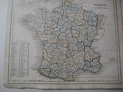
France in Provinces
Publicado por Mid C19
Librería: theoldmapman, Clevedon, SOMER, Reino Unido
Calificación del vendedor: 4 de 5 estrellas

Mapa
EUR 9,53
Envío por EUR 7,52
Se envía de Reino Unido a Estados Unidos de AmericaCantidad disponible: 1 disponibles
Ańadir al carritoSingle sheet. Original outline hand-coloured map. 26 x 21 cm.
-

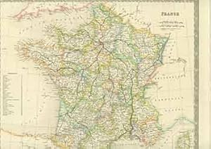
Map of France, 1850 Antique Engraving
Publicado por Orr, UK, 1850
Librería: Maynard & Bradley, Leicester, Reino Unido
Calificación del vendedor: 5 de 5 estrellas

EUR 15,43
Envío por EUR 25,39
Se envía de Reino Unido a Estados Unidos de AmericaCantidad disponible: 1 disponibles
Ańadir al carritoSoftcover. Condición: Good. 1850. A fairly well-presented map, lightly browned and worn around the outer edges but the majority of the image remaining clear and legible with no major signs of wear. Just a few small nicks reinforced with conservation tape, with no major encroachments onto the print itself, vertical fold line as originally presented. Why on Amazon do most sellers not describe their actual book? Buy with confidence and support a genuine Independent Bricks & Mortar Real Bookshop. We are Maynard & Bradley CAMBO & PBFA(now lapsed) members here in Leicester City Centre. Size: 300 x 240 mm. 1. Item Type: Book. Quantity Available: 1. Shipped Weight: Under 500 grams. Category: Geography & Maps; Britain/UK; 19th century; Inventory No: 47265.
-

FRANCE.
Publicado por Orr & Comp Amen Corner Paternoster Row Ca1870, 1870
Librería: PROCTOR / THE ANTIQUE MAP & BOOKSHOP, DORCHESTER, Reino Unido
Miembro de asociación: PBFA
Calificación del vendedor: 5 de 5 estrellas
EUR 15,49
Envío por EUR 23,13
Se envía de Reino Unido a Estados Unidos de AmericaCantidad disponible: 1 disponibles
Ańadir al carritoSize of engraved surface: 25cm x 30cm. In very good condition. Red pen markings on map. Uncoloured.
-
![Imagen del vendedor de France [Map] a la venta por Renaissance Books, ANZAAB / ILAB](https://pictures.abebooks.com/inventory/md/md30544858382.jpg)
France [Map]
Publicado por Orr & Company [c1849], London, 1849
Librería: Renaissance Books, ANZAAB / ILAB, Dunedin, Nueva Zelanda
Miembro de asociación: ANZAAB ILAB
Calificación del vendedor: 5 de 5 estrellas
Mapa
EUR 26,62
Envío por EUR 30,15
Se envía de Nueva Zelanda a Estados Unidos de AmericaCantidad disponible: 1 disponibles
Ańadir al carritoMap. Condición: Very Good. Estado de la sobrecubierta: No Dust Jacket. Moderate foxing. 2 folds. ; No date [c1849]. Dimensions: oblong 272 x 220mm. Drawn and engraved by I. Dower. This map is from James Bell, "A System of Geography, Popular and Scientific [. . .] Vol. II" (London: A. Fullarton and Co., 1849).
-
France
Idioma: Alemán
Ańo de publicación: 1850
Librería: Alte Bücherwelt, Perg, Austria
Calificación del vendedor: 4 de 5 estrellas
EUR 23,00
Envío por EUR 17,50
Se envía de Austria a Estados Unidos de AmericaCantidad disponible: 1 disponibles
Ańadir al carrito23 x 23 cm. Original-Landkarte "France" v. J. Dower, hrsg. 1850, Stahlstich koloriert, guer-sehr guter Zustand, kl. Randlässuren, genuine map Sprache: Deutsch Gewicht in Gramm: 450.
-

Orig. Landkarte "France" ca. 1820
Idioma: Alemán
Publicado por London, Ott & Comp., ca. 1820., 1820
Librería: Alte Bücherwelt, Perg, Austria
Calificación del vendedor: 4 de 5 estrellas
EUR 78,00
Envío por EUR 17,50
Se envía de Austria a Estados Unidos de AmericaCantidad disponible: 1 disponibles
Ańadir al carrito4°, Broschiert. Original Landkarte "France" gest. von J. Dower, hrsg. Ott & Comp., London, ca. 1820, koloriert, Blattgröße ca. 32 x 24 cm.guter-sehr guter Zustand. Sprache: Deutsch Gewicht in Gramm: 850.
-
France. (19th Century Map).
Publicado por London: Henry Teesdale, [1800s]., 1800
Librería: Wittenborn Art Books, San Francisco, CA, Estados Unidos de America
Calificación del vendedor: 5 de 5 estrellas
Manuscrito
EUR 88,72
Envío por EUR 8,61
Se envía dentro de Estados Unidos de AmericaCantidad disponible: 1 disponibles
Ańadir al carritoCondición: Good. 15 x 19 inches. Very Good. Half in tear at top and bottom edges along fold. 19th Century, folded map, printed in color.