Engraving gerard (46 resultados)
 Más imágenes
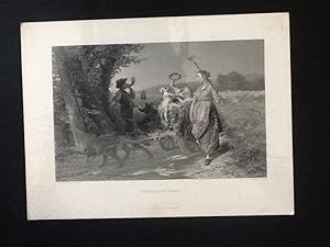
Editorial: D Appleton & Co, New York, 1878
- Lámina artística
Librería: Sheapast Art and Books, Sherman Oaks, CA, Estados Unidos de AmericaSheapast Art and Books
Contactar con el vendedorVendedor de 5 estrellasCondición: Usado - Aceptable
EUR 13,50
Envío por EUR 4,70Se envía dentro de Estados Unidos de AmericaCantidad disponible: 1 disponibles
No Binding. Condición: Good. Returning Home (antique engraving) engraved by J C Finden after a painting by Thomas Gerard published in Art Journal, 1878 overall 12 3/4 x 9 1/2 ins wrapped in protective plastic MEDBLK.
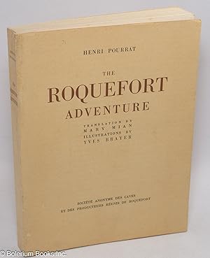
Editorial: Societe Anonyme des Caves et des Producteurs Reunis de Roquefort, Coulouma, France, 1956
- Tapa blanda
- Primera edición
Librería: Bolerium Books Inc., San Francisco, CA, Estados Unidos de AmericaBolerium Books Inc.
Contactar con el vendedorVendedor de 5 estrellasCondición: Usado
EUR 35,12
Gastos de envío gratisSe envía dentro de Estados Unidos de AmericaCantidad disponible: 1 disponibles
Paperback. First edition of the "original English edition of this book", numerous illustrations (exceptional conception & coloring), No.3242 of a run of 5000 copies, 237p., fine presswork on lovely watermarked paperstock, softbound in 9.5x7 inch buff wraps titled in brown and black. Faint-ish dustsoil and faint irregular sunning…, within expect a few flecks otherwise near-new, sound and unmarked (no ownerships, institutional slugs or marginal notes). Roquefort, it turns out, is pretty weird; the best is formed in cold mountainous caverns. Refrigeration? --still yummy. Laid in are the mailing label from the Societe' to Pasadena CA and a printed cover notice.

Editorial: British Archaeological Association, UK, 1853
- Tapa blanda
Librería: Maynard & Bradley, Leicester, Reino UnidoMaynard & Bradley
Contactar con el vendedorVendedor de 5 estrellasCondición: Usado - Aceptable
EUR 15,57
Envío por EUR 25,62Se envía de Reino Unido a Estados Unidos de AmericaCantidad disponible: 1 disponibles
Softcover. Condición: Good. 1853. A clean and well-presented plan and diagram, produced in 1853 for the British Archaeological Association. Some spots affect the outer edges, but the printed matter itself remains largely clear and well-presented. Neatly trimmed to prevent edge wear, thus fairly well-presented. Why on Amazon do m…ost sellers not describe their actual book? Buy with confidence and support a genuine Independent Bricks & Mortar Real Bookshop. We are Maynard & Bradley CAMBO & PBFA(now lapsed) members here in Leicester City Centre. Size: 195 x 140 mm. 1. Item Type: Book. Quantity Available: 1. Shipped Weight: Under 500 grams. Category: Archaeology; Britain/UK; 19th century; Inventory No: 54068.

Editorial: Société Anonyme des, Roquefort, 1956
- Tapa blanda
Librería: Antiquariat Johann Forster, Friedenweiler, BW, AlemaniaAntiquariat Johann Forster
Contactar con el vendedorVendedor de 5 estrellasCondición: Usado
EUR 30,00
Envío por EUR 15,00Se envía de Alemania a Estados Unidos de AmericaCantidad disponible: 1 disponibles
OKart.. Condición: in bestem Zustand. (s. Foto). Roquefort, Société Anonyme des , 1956. Gr.8°. 235 S. mit farbigen Illustraionen von Yves Brayer. OKart., in bestem Zustand. (s. Foto). Nr. 420 von 5000 numerierten Exemplaren. Sprache: eng.

Idioma: Inglés
Librería: K Books Ltd ABA ILAB, York, YORKS, Reino UnidoK Books Ltd ABA ILAB
Contactar con el vendedorVendedor de 5 estrellasCondición: Usado - Bueno
EUR 18,04
Envío por EUR 22,76Se envía de Reino Unido a Estados Unidos de AmericaCantidad disponible: 1 disponibles
No Binding. Condición: Very Good. an Original Antique Engraving. Mounted/matted and ready to frame. Excellent condition. An attractive and decorative engraving.

Idioma: Francés
- Lámina artística
Librería: Antiquariat Steffen Völkel GmbH, Seubersdorf, AlemaniaAntiquariat Steffen Völkel GmbH
Contactar con el vendedorVendedor de 5 estrellasCondición: Usado
EUR 3,99
Envío por EUR 30,00Se envía de Alemania a Estados Unidos de AmericaCantidad disponible: 1 disponibles
Original Stahlstich von ca. 1850 -- Blatt-Maße: ca. 12,5 x 20 cm -- Bild-Maße: ca. 10 x 14,5 cm -- gut erhalten. -- original steel engraving from around 1850 - in good condition. // Wir, das Antiquariat Steffen Völkel, kaufen und verkaufen alte Bücher, Handschriften, Zeichnungen, Autographen, Grafiken und Fotografien. Wir sind s…tets am Ankauf von kompletten Bibliotheken, Sammlungen und Nachlässen interessiert. Sprache: Französisch Gewicht in Gramm: 10.
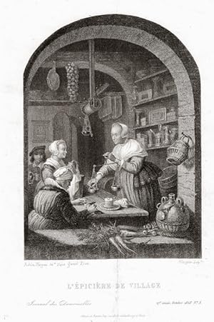
Editorial: Fisher&son
- Lámina artística
Librería: Artisans-lane Maps & Prints, Sidney, BC, CanadaArtisans-lane Maps & Prints
Contactar con el vendedorVendedor de 4 estrellasCondición: Usado - Bueno
EUR 19,02
Envío por EUR 16,61Se envía de Canada a Estados Unidos de AmericaCantidad disponible: 1 disponibles
no binding. Condición: very good. Engraved by Adrien Nargeon after "L'Epicure de Village" by Gerard Dow, a prominent Dutch Golden Age artist born on April 7, 1613, in Leiden, stands as a remarkable testament to his skill in portraying everyday life with meticulous precision. Translating to "The Village Grocer" in English, the pa…inting depicts a scene of a village grocer, capturing the essence of Dutch daily life during the 17th century. Notably, Dow included his self-portrait in the background, adding a personal touch to the composition. Known as the principal representative of the Leiden fijnschilders, or fine painters, Gerard Dou's work is celebrated for its finely executed details. The painting is housed in the Louvre Museum in Paris, where it contributes to the rich collection of Dutch Golden Age art, showcasing Dow's enduring impact on the art world. He passed away on February 9, 1675, leaving behind a legacy of exceptional craftsmanship and an insightful portrayal of Dutch society. Approximate Image Size: 5 3/4 ins x 4 1/4 ins . Approximate Overall Size: 8 1/2 ins x 6 1/2 ins. Printed on heavier paper. Blank on the back. NOTE THE FOLLOWING BEFORE YOU PURCHASE: This is a GENUINE VINTAGE/ANTIQUE PRINT. It is NOT a modern reproduction, ie. a laser scan, photocopy etc. It is the original from the vintage/antique publication. This print was published on the date mentioned, or circa of the date mentioned at the top of the page. The term "print" is referred to an image on a piece of paper. The print I have for sale, like many vintage/antique prints that you see online, originate from an antique or vintage book or atlas publication. The publication may not always be known. If you have any questions, emails are welcome.
 Más imágenes
Editorial: PAYNE
- Lámina artística
Librería: Artisans-lane Maps & Prints, Sidney, BC, CanadaArtisans-lane Maps & Prints
Contactar con el vendedorVendedor de 4 estrellasCondición: Usado - Bueno
EUR 25,36
Envío por EUR 21,85Se envía de Canada a Estados Unidos de AmericaCantidad disponible: 1 disponibles
no binding. Condición: very good. Approximate Image Size: 5 X 6 1/2 inches Approximate Overall Size With Margins: 8 X 10 1/2 inches. CONDITION: Very Good Condition. Image is sharp, clean, clear with beautiful detail and in Very Good to Excellent Condition. Printed on heavier paper. Blank on Reverse side. Done in the right matte…and frame, this print would look exquisite. An art supply store can provide you with a selection of frames for old art treasures. NOTE THE FOLLOWING BEFORE YOU PURCHASE: This is a GENUINE ANTIQUE PRINT. It is NOT a modern reproduction, ie. a laser scan, photocopy etc. This print was published on the date mentioned, or circa of the date mentioned at the top of the page. The term "print" is referred to an image on a piece of paper. The print I have for sale, like many antique prints, originate from an antique book publication. The publication may not always be known. If you have any questions, THE WORDS "GENUINE ANTIQUE PRINT SCANNED FOR VINTAGE-VIEWS" IS A DIGITAL IMAGE AND IS NOT PRINTED ON THE ACTUAL PRINT.

Editorial: Revista la Ilustración española y americana, Madrid, 1880
- Manuscrito
Librería: LIBRERÍA MAESTRO GOZALBO, Carcaixent, V, EspañaLIBRERÍA MAESTRO GOZALBO
Contactar con el vendedorVendedor de 5 estrellasCondición: Usado
EUR 20,80
Envío por EUR 50,00Se envía de España a Estados Unidos de AmericaCantidad disponible: 1 disponibles
1º Edición. 1 pag plegada 1 pag. Marcas de encuadernación. Leve oscurecido, 44x33 CM (SIN CONTAR MÁRGENES, solamente la imagen, sin el marco negro exterior) Grabado perteneciente a la revista La ilustración Española y Americana, año 1880. Madrid. Nº XXVIII. HOMERO COPIA DEL CUADRO DE F GÉRARD GRABADO EN ACERO POR MASSARD. Marcas… de encuadernación. Leve oscurecido.

Idioma: Alemán
- Lámina artística
Librería: Antiquariat Steffen Völkel GmbH, Seubersdorf, AlemaniaAntiquariat Steffen Völkel GmbH
Contactar con el vendedorVendedor de 5 estrellasCondición: Usado
EUR 4,99
Envío por EUR 30,00Se envía de Alemania a Estados Unidos de AmericaCantidad disponible: 1 disponibles
(KN 27956) Gerard Melder (1693 - 1754) originalKupferstich-Portraitvon ca. 1750 auf voller Buchseite Rückseite bedruckt mit beiliegendemTextblatt mit Biographie Platten-Masse (Bild)ca. 10,5 x 7,5 cm Blattmasse ca.12 x19,5cm gut erhalten Original! - Kein Nachdruck! - Keine Kopie! // Wir, das Antiquariat Steffen Völkel, kaufen und… verkaufen alte Bücher, Handschriften, Zeichnungen, Autographen, Grafiken und Fotografien. Wir sind stets am Ankauf von kompletten Bibliotheken, Sammlungen und Nachlässen interessiert. Sprache: Deutsch Gewicht in Gramm: 10.
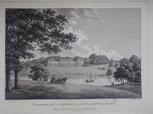
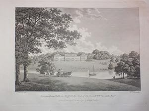
Original Antique Engraving Illustrating Heveningham Hall in Suffolk, the Seat of Sir Gerard Wm. Vanneck, By W. Watts and Published in 1779.
Original Engraved Illustration from The Seats of the Nobility and Gentry By W. Watts.
Editorial: Watts, Chelsea, 1779
- Lámina artística
Librería: Rostron & Edwards, Shropshire, Reino UnidoRostron & Edwards
Contactar con el vendedorVendedor de 5 estrellasCondición: Usado - Bueno
EUR 57,71
Envío por EUR 22,12Se envía de Reino Unido a Estados Unidos de AmericaCantidad disponible: 1 disponibles
No Binding. Condición: Very Good. A single original antique engraving from The Seats of The Nobility and Gentry by W. Watts. Published in 1779. This one illustrating Heveningham Hall in Suffolk, the Seat of Sir Gerard Wm. Vanneck Engraved by W. Watts. With a separate page of descriptive text. Illustration size approx 13 x 19cm.…Titled and dated 1st of May 1782. An original engraving. Ready for framing. Good condition. We specialise in fine antique prints of historic & listed buildings. Search our stock for further items on Heveningham Hall. Watts (ilustrador).

- Lámina artística
Librería: ThePrintsCollector, Zeeland, HolandaThePrintsCollector
Contactar con el vendedorVendedor de 5 estrellasCondición: Usado
EUR 24,50
Envío por EUR 18,00Se envía de Holanda a Estados Unidos de AmericaCantidad disponible: 1 disponibles
Plate: 'Gravure ayant obtenu le premier prix a l'exposition de 1799.' (Engraving winning the first prize at an exibition in France in 1799). Engraved by J. Godefroy after F. Gerard. Original lithograph on a vellin type paper. Description: This attractive original old antique print / plate originates from: 'Directoire, consulat e…n empire. Moeurs et usages, lettres, sciences et arts. France. 1795-1815.' (Customs, habits and costumes of France during the Empire period, 1795-1815).), by Paul Lacroix, published in Paris by Firmin-Didot et Cie. , 1884.Artists and Engravers: Paul Lacroix (1806-1884), French author and journalist. He is best known under his pseudonym of P.L. Jacob, bibliophile, or Bibliophile Jacob. The lithograph is by Mauler. Condition: Excellent given its age. General age related toning and occasional light staining / foxing. Please study scan carefully. Storage location: C154-48 The overall size is ca. 7.3 x 11 inch. The image size is ca. 5.3 x 7.3 inch. The overall size is ca. 18.5 x 28 cm. The image size is ca. 13.5 x 18.5 cm.

La Lecon Interrompue [original Stipple Engraving After Niklas Lafrensen / Lavrince, By Gerard Vidal
Lafrensen, Niklas [AKA Lavrence, Lavrince] [1737-1801] and Gerard Vidal [1742-1801]
Idioma: Francés
Editorial: Chez Gerard Vidal, Paris Circa 1780, 1780
- Lámina artística
Librería: Arroyo Seco Books, Pasadena, Member IOBA, Pasadena, CA, Estados Unidos de AmericaArroyo Seco Books, Pasadena, Member IOBA
Contactar con el vendedorVendedor de 4 estrellasMiembro de asociación: IOBA
Condición: Usado - Bueno
EUR 106,16
Envío por EUR 6,99Se envía dentro de Estados Unidos de AmericaCantidad disponible: 1 disponibles
No Binding. Condición: Very Good. Early Printing. An original eighteenth century stipple engraving by Vidal after a painting by Lafrensen [credited here as "Lavrince"]. Well printed, pleasing color, wide margins which have a little dust and were folded about 3/8" beyond the image area [which is 8 1/4" x 11 1/8", with printing up… to 1" below bottom edge of the illustration], but within the plate mark. Lafrensen, Niklas [AKA Lavrence, Lavrince] [1737-1801] and Gerard Vidal [1742-1801] (ilustrador).
Idioma: Francés
Editorial: Paris, 1696
- Lámina artística
Librería: J & J LUBRANO MUSIC ANTIQUARIANS LLC, Syosset, NY, Estados Unidos de AmericaJ & J LUBRANO MUSIC ANTIQUARIANS LLC
Contactar con el vendedorVendedor de 5 estrellasCondición: Usado
EUR 259,31
Envío por EUR 10,93Se envía dentro de Estados Unidos de AmericaCantidad disponible: 1 disponibles
Quinault is depicted head-and-shoulders, turned quarter right, wearing a robe and long wig. Coat of arms to lower portion of oval border, "Philippe Quinault Auditeur des Comptes de l'Academie francoise" printed below Image size 255 x 192 mm; sheet size 290 212 mm. With an 18 mm tear to upper right margin just touching printed ar…ea. "Edelinck's engraving beautifully encapsulates Quinault's position as a dramatist, auditor and member of the Académie Française during the reign of Louis XIV. To contextualize, Philippe Quinault wrote the librettos for several of Jean-Baptiste Lully's operas, a partnership crucial in establishing French opera as its own distinctive art form. How might that relationship to power through music, have played out in society? a striking example of Baroque portraiture." Artera website.

Editorial: I.E. Cloppenburgh, Amsterdam, 1630
- Mapa
Librería: Antiquariat Reinhold Berg eK Inh. R.Berg, Regensburg, AlemaniaAntiquariat Reinhold Berg eK Inh. R.Berg
Contactar con el vendedorVendedor de 5 estrellasCondición: Usado
EUR 100,00
Envío por EUR 24,00Se envía de Alemania a Estados Unidos de AmericaCantidad disponible: 1 disponibles
Hand-Colored Original Copperplate Engraving by Gerard Mercator, depicting Westphalia cum Dioecesi Bremensi. Published Amsterdam, I.E. Cloppenburgh, 1630. Sheet: 18.5 x 25,3 cm (7.25 x 10 inches). A fine and original hand-colored example of Mercator's celebrated cartographic work, documenting this region of Germany with the preci…sion and decorative artistry characteristic of the 16300s. Gerardus Mercator (1512-1594) was the greatest cartographer of the 16th century. Born in Flanders, he invented the Mercator projection in 1569 -- a revolutionary cylindrical map projection still used in nautical charts today. He was the first to use the word 'atlas' for a collection of maps, honouring the Titan who held up the world. His 1585 atlas of France, Germany, and the Low Countries was the first in a series that would be completed and republished by his heirs and successors, most notably Hondius and Janssonius. Mercator maps are prized by collectors for their historical importance and elegant Renaissance engraving, and are held in leading institutions including the BibliothËque nationale de France and the British Library.This original copperplate engraving, with original hand coloring depicts the region of Westphalia cum Dioecesi Bremensi, published in Amsterdam, I.E. Cloppenburgh, 1630. The map records the political and geographic boundaries of the region as understood in 1630, offering a fascinating window into the history of German territorial organization. Sheet measures 18.5 x 25,3 cm (7.25 x 10 inches). In good condition overall, with minor signs of age appropriate for a 17th-century engraving. Ready to frame. Koeman ME 206 In gutem Zustand. Einige hinterlegte Einrisse am Rand außerhalb des Kartenbildes. 18.5 x 25,3 cm (7.25 x 10 inches).

Editorial: I.E. Cloppenburgh, Amsterdam, 1632
- Mapa
Librería: Antiquariat Reinhold Berg eK Inh. R.Berg, Regensburg, AlemaniaAntiquariat Reinhold Berg eK Inh. R.Berg
Contactar con el vendedorVendedor de 5 estrellasCondición: Usado
EUR 125,00
Envío por EUR 24,00Se envía de Alemania a Estados Unidos de AmericaCantidad disponible: 1 disponibles
Other. Hand-Colored Original Copperplate Engraving by Gerard Mercator, depicting Frisia occidentalis. Published Amsterdam, I.E. Cloppenburgh, 1632. Sheet: 184 by 252mm (7 by 10 inches). A fine and original hand-colored example of Mercator's celebrated cartographic work, documenting this region of Germany with the precision and d…ecorative artistry characteristic of the 16300s. Gerardus Mercator (1512-1594) was the greatest cartographer of the 16th century. Born in Flanders, he invented the Mercator projection in 1569 -- a revolutionary cylindrical map projection still used in nautical charts today. He was the first to use the word 'atlas' for a collection of maps, honouring the Titan who held up the world. His 1585 atlas of France, Germany, and the Low Countries was the first in a series that would be completed and republished by his heirs and successors, most notably Hondius and Janssonius. Mercator maps are prized by collectors for their historical importance and elegant Renaissance engraving, and are held in leading institutions including the BibliothËque nationale de France and the British Library.This original copperplate engraving, with original hand coloring depicts the region of Frisia occidentalis, published in Amsterdam, I.E. Cloppenburgh, 1632. The map records the political and geographic boundaries of the region as understood in 1632, offering a fascinating window into the history of German territorial organization. Sheet measures 184 by 252mm (7 by 10 inches). In good condition overall, with minor signs of age appropriate for a 17th-century engraving. Ready to frame. In excellent condition. 184 by 252mm (7 by 10 inches).

Editorial: I.E. Cloppenburgh, Amsterdam, 1630
- Mapa
Librería: Antiquariat Reinhold Berg eK Inh. R.Berg, Regensburg, AlemaniaAntiquariat Reinhold Berg eK Inh. R.Berg
Contactar con el vendedorVendedor de 5 estrellasCondición: Usado
EUR 145,00
Envío por EUR 24,00Se envía de Alemania a Estados Unidos de AmericaCantidad disponible: 1 disponibles
No Binding. Original Copperplate Engraving by Gerard Mercator, depicting Palatinatus Rheni. Published Amsterdam, I.E. Cloppenburgh, 1630. Sheet: 187 by 257mm (7 by 10 inches). A fine and example of Mercator's celebrated cartographic work, documenting this region of Germany with the precision and decorative artistry characteristi…c of the 16300s. Gerardus Mercator (1512-1594) was the greatest cartographer of the 16th century. Born in Flanders, he invented the Mercator projection in 1569 -- a revolutionary cylindrical map projection still used in nautical charts today. He was the first to use the word 'atlas' for a collection of maps, honouring the Titan who held up the world. His 1585 atlas of France, Germany, and the Low Countries was the first in a series that would be completed and republished by his heirs and successors, most notably Hondius and Janssonius. Mercator maps are prized by collectors for their historical importance and elegant Renaissance engraving, and are held in leading institutions including the BibliothËque nationale de France and the British Library.This original copperplate engraving depicts the region of Palatinatus Rheni, published in Amsterdam, I.E. Cloppenburgh, 1630. The map records the political and geographic boundaries of the region as understood in 1630., offering a fascinating window into the history of German territorial organization. Sheet measures 187 by 257mm (7 by 10 inches). In good condition overall, with minor signs of age appropriate for a 17th-century engraving. Ready to frame. Koeman, ME 198 In excellent condition. 187 by 257mm (7 by 10 inches). 187 by 257mm (7 by 10 inches).

Editorial: I.E. Cloppenburgh, Amsterdam, 1632
- Mapa
Librería: Antiquariat Reinhold Berg eK Inh. R.Berg, Regensburg, AlemaniaAntiquariat Reinhold Berg eK Inh. R.Berg
Contactar con el vendedorVendedor de 5 estrellasCondición: Usado
EUR 145,00
Envío por EUR 24,00Se envía de Alemania a Estados Unidos de AmericaCantidad disponible: 1 disponibles
Other. Hand-Colored Original Copperplate Engraving by Gerard Mercator, depicting Germania. Published Amsterdam, I.E. Cloppenburgh, 1632. Sheet: 183 by 250mm (7 by 9 inches). A fine and original hand-colored example of Mercator's celebrated cartographic work, documenting this region of Germany with the precision and decorative ar…tistry characteristic of the 16300s. Gerardus Mercator (1512-1594) was the greatest cartographer of the 16th century. Born in Flanders, he invented the Mercator projection in 1569 -- a revolutionary cylindrical map projection still used in nautical charts today. He was the first to use the word 'atlas' for a collection of maps, honouring the Titan who held up the world. His 1585 atlas of France, Germany, and the Low Countries was the first in a series that would be completed and republished by his heirs and successors, most notably Hondius and Janssonius. Mercator maps are prized by collectors for their historical importance and elegant Renaissance engraving, and are held in leading institutions including the BibliothËque nationale de France and the British Library.This original copperplate engraving, with original hand coloring depicts the region of Germania, published in Amsterdam, I.E. Cloppenburgh, 1632. The map records the political and geographic boundaries of the region as understood in 1632, offering a fascinating window into the history of German territorial organization. Sheet measures 183 by 250mm (7 by 9 inches). In good condition overall, with minor signs of age appropriate for a 17th-century engraving. Ready to frame. In excellent condition. 183 by 250mm (7 by 9 inches).

Editorial: I.E. Cloppenburgh,, Amsterdam, 1632
- Mapa
Librería: Antiquariat Reinhold Berg eK Inh. R.Berg, Regensburg, AlemaniaAntiquariat Reinhold Berg eK Inh. R.Berg
Contactar con el vendedorVendedor de 5 estrellasCondición: Usado
EUR 145,00
Envío por EUR 24,00Se envía de Alemania a Estados Unidos de AmericaCantidad disponible: 1 disponibles
Hand-Colored Original Copperplate Engraving by Gerard Mercator, depicting Rugiae. Published Amsterdam, I.E. Cloppenburgh, 1632. Sheet: 18.7 x 25,5 cm (7.25 x 10 inches). A fine and original hand-colored example of Mercator's celebrated cartographic work, documenting this region of Germany with the precision and decorative artist…ry characteristic of the 16300s. Gerardus Mercator (1512-1594) was the greatest cartographer of the 16th century. Born in Flanders, he invented the Mercator projection in 1569 -- a revolutionary cylindrical map projection still used in nautical charts today. He was the first to use the word 'atlas' for a collection of maps, honouring the Titan who held up the world. His 1585 atlas of France, Germany, and the Low Countries was the first in a series that would be completed and republished by his heirs and successors, most notably Hondius and Janssonius. Mercator maps are prized by collectors for their historical importance and elegant Renaissance engraving, and are held in leading institutions including the BibliothËque nationale de France and the British Library.This original copperplate engraving, with original hand coloring depicts the region of Rugiae, published in Amsterdam, I.E. Cloppenburgh, 1632. The map records the political and geographic boundaries of the region as understood in 1632, offering a fascinating window into the history of German territorial organization. Sheet measures 18.7 x 25,5 cm (7.25 x 10 inches). In good condition overall, with minor signs of age appropriate for a 17th-century engraving. Ready to frame. In excellent condition. 18.7 x 25,5 cm (7.25 x 10 inches).

Editorial: I.E. Cloppenburgh, Amsterdam, 1632
- Firmado
- Mapa
Librería: Antiquariat Reinhold Berg eK Inh. R.Berg, Regensburg, AlemaniaAntiquariat Reinhold Berg eK Inh. R.Berg
Contactar con el vendedorVendedor de 5 estrellasCondición: Usado
EUR 145,00
Envío por EUR 24,00Se envía de Alemania a Estados Unidos de AmericaCantidad disponible: 1 disponibles
Original antique copper engraving, uncolored, from the Mercator Atlas, published in Amsterdam, 1632. Depicting Sardinia, this map is a fine example of 1630s European cartography. Image: 18.6 x 12,9 cm (7.25 x 5 inches). An attractive and historically significant 17th-century map for the discerning collector. Gerard Mercator (151…21594) was a Flemish cartographer and mathematician, celebrated as one of the most influential figures in the history of mapmaking. Born in Rupelmonde, he developed the Mercator projection in 1569a cylindrical map projection that became the standard for nautical navigation and remains widely used today. His monumental 'Atlas sive Cosmographicae Meditationes de Fabrica Mundi' (1595), completed posthumously by his son Rumold, introduced the word 'Atlas' to cartography. Mercator's regional maps of Italy were refined and re-engraved for multiple editions of his atlas throughout the 17th century, offering collectors both scholarly precision and decorative elegance. His maps are held at the Royal Library of Belgium, the Bibliothèque nationale de France, and major university collections worldwide.This is an engraved map of the island of Sardinia. This old map was published first in the so-called Cloppenburgh editions which was a competive edition with new engraved maps in a larger format. Most of the maps were engraved by Pieter van den Keere. The Cloppenburgh edition was continued for a couple of years but seems to have been suppressed after 1636. This is another Cloppenburgh edition, now with Latin text. The maps from the Appendix have been incorporated. The title-page is followed by a dedication to Prince Frederik Hendrik, dated 1632 and signed by Johannes Cloppenburgh. (Koeman Atlantes Neerlandici).A fine example from Mercator Atlas / Cosmographicae Meditationes, Amsterdam, sought after by collectors of antique maps of Italy, antique maps of Sardinia, and antique copper engraving, uncoloreds for sale. In good condition consistent with age. Light age-toning to the sheet, as expected for a 17th-century engraving. Centerfold as published. In very good to excellent condition. 18.6 x 12,9 cm (7.25 x 5 inches).

Editorial: I.E. Cloppenburgh, Amsterdam, 1630
- Mapa
Librería: Antiquariat Reinhold Berg eK Inh. R.Berg, Regensburg, AlemaniaAntiquariat Reinhold Berg eK Inh. R.Berg
Contactar con el vendedorVendedor de 5 estrellasCondición: Usado
EUR 145,00
Envío por EUR 24,00Se envía de Alemania a Estados Unidos de AmericaCantidad disponible: 1 disponibles
Other. Hand-Colored Original Copperplate Engraving by Gerard Mercator, depicting Waldeck Comitatus. Published Amsterdam, I.E. Cloppenburgh, 1630. Sheet: 180 by 248mm (7 by 9 inches). A fine and original hand-colored example of Mercator's celebrated cartographic work, documenting this region of Germany with the precision and deco…rative artistry characteristic of the 16300s. Gerardus Mercator (1512-1594) was the greatest cartographer of the 16th century. Born in Flanders, he invented the Mercator projection in 1569 -- a revolutionary cylindrical map projection still used in nautical charts today. He was the first to use the word 'atlas' for a collection of maps, honouring the Titan who held up the world. His 1585 atlas of France, Germany, and the Low Countries was the first in a series that would be completed and republished by his heirs and successors, most notably Hondius and Janssonius. Mercator maps are prized by collectors for their historical importance and elegant Renaissance engraving, and are held in leading institutions including the BibliothËque nationale de France and the British Library.This original copperplate engraving, with original hand coloring depicts the region of Waldeck Comitatus., published in Amsterdam, I.E. Cloppenburgh, 1630. The map records the political and geographic boundaries of the region as understood in 1630, offering a fascinating window into the history of German territorial organization. Sheet measures 180 by 248mm (7 by 9 inches). In good condition overall, with minor signs of age appropriate for a 17th-century engraving. Ready to frame. Koeman, ME 198 In excellent condition. 180 by 248mm (7 by 9 inches). 180 by 248mm (7 by 9 inches).

Editorial: I.E. Cloppenburgh, Amsterdam, 1630
- Mapa
Librería: Antiquariat Reinhold Berg eK Inh. R.Berg, Regensburg, AlemaniaAntiquariat Reinhold Berg eK Inh. R.Berg
Contactar con el vendedorVendedor de 5 estrellasCondición: Usado
EUR 145,00
Envío por EUR 24,00Se envía de Alemania a Estados Unidos de AmericaCantidad disponible: 1 disponibles
Other. Hand-Colored Original Copperplate Engraving by Gerard Mercator, depicting Nassovia Comitatus. Published Amsterdam, I.E. Cloppenburgh, 1630. Sheet: 183 by 252mm (7 by 10 inches). A fine and original hand-colored example of Mercator's celebrated cartographic work, documenting this region of Germany with the precision and de…corative artistry characteristic of the 16300s. Gerardus Mercator (1512-1594) was the greatest cartographer of the 16th century. Born in Flanders, he invented the Mercator projection in 1569 -- a revolutionary cylindrical map projection still used in nautical charts today. He was the first to use the word 'atlas' for a collection of maps, honouring the Titan who held up the world. His 1585 atlas of France, Germany, and the Low Countries was the first in a series that would be completed and republished by his heirs and successors, most notably Hondius and Janssonius. Mercator maps are prized by collectors for their historical importance and elegant Renaissance engraving, and are held in leading institutions including the BibliothËque nationale de France and the British Library.This original copperplate engraving, with original hand coloring depicts the region of Nassovia Comitatus., published in Amsterdam, I.E. Cloppenburgh, 1630. The map records the political and geographic boundaries of the region as understood in 1630, offering a fascinating window into the history of German territorial organization. Sheet measures 183 by 252mm (7 by 10 inches). In good condition overall, with minor signs of age appropriate for a 17th-century engraving. Ready to frame. Koeman, ME 198 In excellent condition. 183 by 252mm (7 by 10 inches). 183 by 252mm (7 by 10 inches).

Editorial: I.E. Cloppenburgh, Amsterdam, 1630
- Mapa
Librería: Antiquariat Reinhold Berg eK Inh. R.Berg, Regensburg, AlemaniaAntiquariat Reinhold Berg eK Inh. R.Berg
Contactar con el vendedorVendedor de 5 estrellasCondición: Usado
EUR 145,00
Envío por EUR 24,00Se envía de Alemania a Estados Unidos de AmericaCantidad disponible: 1 disponibles
Other. Hand-Colored Original Copperplate Engraving by Gerard Mercator, depicting Hassia Landgraviatus. Published Amsterdam, I.E. Cloppenburgh, 1630. Sheet: 187 by 257mm (7 by 10 inches). A fine and original hand-colored example of Mercator's celebrated cartographic work, documenting this region of Germany with the precision and…decorative artistry characteristic of the 16300s. Gerardus Mercator (1512-1594) was the greatest cartographer of the 16th century. Born in Flanders, he invented the Mercator projection in 1569 -- a revolutionary cylindrical map projection still used in nautical charts today. He was the first to use the word 'atlas' for a collection of maps, honouring the Titan who held up the world. His 1585 atlas of France, Germany, and the Low Countries was the first in a series that would be completed and republished by his heirs and successors, most notably Hondius and Janssonius. Mercator maps are prized by collectors for their historical importance and elegant Renaissance engraving, and are held in leading institutions including the BibliothËque nationale de France and the British Library.This original copperplate engraving, with original hand coloring depicts the region of Hassia Landgraviatus, published in Amsterdam, I.E. Cloppenburgh, 1630. The map records the political and geographic boundaries of the region as understood in 1630, offering a fascinating window into the history of German territorial organization. Sheet measures 187 by 257mm (7 by 10 inches). In good condition overall, with minor signs of age appropriate for a 17th-century engraving. Ready to frame. Koeman, ME 198 In excellent condition. 187 by 257mm (7 by 10 inches). 187 by 257mm (7 by 10 inches).

Editorial: Gerard Mercator, Amsterdam, 1630
- Mapa
Librería: Antiquariat Reinhold Berg eK Inh. R.Berg, Regensburg, AlemaniaAntiquariat Reinhold Berg eK Inh. R.Berg
Contactar con el vendedorVendedor de 5 estrellasCondición: Usado
EUR 195,00
Envío por EUR 24,00Se envía de Alemania a Estados Unidos de AmericaCantidad disponible: 1 disponibles
Hand-Colored Original Copperplate Engraving by Gerard Mercator, depicting Palatinatus Bavariae. Published Amsterdam, Gerard Mercator, 1630. Sheet: 37.5 x 50,2 cm (14.75 x 19,75 inches). A fine and original hand-colored example of Mercator's celebrated cartographic work, documenting this region of Germany with the precision and d…ecorative artistry characteristic of the 16300s. Gerardus Mercator (1512-1594) was the greatest cartographer of the 16th century. Born in Flanders, he invented the Mercator projection in 1569 -- a revolutionary cylindrical map projection still used in nautical charts today. He was the first to use the word 'atlas' for a collection of maps, honouring the Titan who held up the world. His 1585 atlas of France, Germany, and the Low Countries was the first in a series that would be completed and republished by his heirs and successors, most notably Hondius and Janssonius. Mercator maps are prized by collectors for their historical importance and elegant Renaissance engraving, and are held in leading institutions including the BibliothËque nationale de France and the British Library.This original copperplate engraving, with original hand coloring depicts the region of Palatinatus Bavariae, published in Amsterdam, Gerard Mercator, 1630. The map records the political and geographic boundaries of the region as understood in 1630, offering a fascinating window into the history of German territorial organization. Sheet measures 37.5 x 50,2 cm (14.75 x 19,75 inches). In good condition overall, with minor signs of age appropriate for a 17th-century engraving. Ready to frame. In good condition. Sheet browned, oxidation from the old coloring visible on the reverse. 37.5 x 50,2 cm (14.75 x 19,75 inches).

Editorial: I.E. Cloppenburgh, Amsterdam, 1632
- Firmado
- Mapa
Librería: Antiquariat Reinhold Berg eK Inh. R.Berg, Regensburg, AlemaniaAntiquariat Reinhold Berg eK Inh. R.Berg
Contactar con el vendedorVendedor de 5 estrellasCondición: Usado
EUR 240,00
Envío por EUR 24,00Se envía de Alemania a Estados Unidos de AmericaCantidad disponible: 1 disponibles
Other. Copper Engraving, uncolored by Mercator, Gerard, published 1632 by I.E. Cloppenburgh, Amsterdam. Image size: 190 by 257mm (7 by 10 inches). By Gerard Mercator the most celebrated name in the entire history of cartography. Gerard Mercator (15121594) was the most influential cartographer in the history of Western mapping. H…is 1569 world map introducing the Mercator projection in which rhumb lines appear as straight lines revolutionized navigation and remains the basis of most world maps today. His posthumously completed Atlas sive cosmographicae meditationes (1595) introduced the word 'atlas' to describe a bound collection of maps. Mercator's maps of individual regions, including his celebrated depictions of the Americas and New Spain, were engraved to the highest standard of the 16th century and were republished throughout the 17th century in the renowned Amsterdam atlas tradition. Maps bearing Mercator's name are among the most historically significant antique maps that can be acquired, representing the very foundation of modern cartography.The map shows the south west part of Mexico. This is the first so-called Cloppenburgh editions which was a competive edition with new engraved maps in a larger format. Most of the maps were engraved by Pieter van den Keere. The Cloppenburgh edition was continued for a couple of years but seems to have been suppressed after 1636. This is another Cloppenburgh edition, now with Latin text. The maps from the Appendix have been incorporated. The title-page is followed by a dedication to Prince Frederik Hendrik, dated 1632 and signed by Johannes Cloppenburgh. (Koeman Atlantes Neerlandici). Netherlands. Koeman, ME 200 In excellent condition. 190 by 257mm (7 by 10 inches). 190 by 257mm (7 by 10 inches).

Editorial: Hendrik Hondius & Gerard Mercator, Amsterdam, 1627
- Mapa
Librería: Antiquariat Reinhold Berg eK Inh. R.Berg, Regensburg, AlemaniaAntiquariat Reinhold Berg eK Inh. R.Berg
Contactar con el vendedorVendedor de 5 estrellasCondición: Usado
EUR 245,00
Envío por EUR 24,00Se envía de Alemania a Estados Unidos de AmericaCantidad disponible: 1 disponibles
Other. Hand-Colored Original Copperplate Engraving by Hendrik Hondius & Gerard Mercator, depicting Oberbayern. Published Amsterdam, Hendrik Hondius & Gerard Mercator, 1627. Sheet: 365 by 480mm (14 by 19 inches). A fine and original hand-colored example of Hondius's celebrated cartographic work, documenting this region of Germany… with the precision and decorative artistry characteristic of the 16200s. Gerardus Mercator (1512-1594) was the greatest cartographer of the 16th century. Born in Flanders, he invented the Mercator projection in 1569 -- a revolutionary cylindrical map projection still used in nautical charts today. He was the first to use the word 'atlas' for a collection of maps, honouring the Titan who held up the world. His 1585 atlas of France, Germany, and the Low Countries was the first in a series that would be completed and republished by his heirs and successors, most notably Hondius and Janssonius. Mercator maps are prized by collectors for their historical importance and elegant Renaissance engraving, and are held in leading institutions including the BibliothËque nationale de France and the British Library.This original copperplate engraving, with original hand coloring depicts the region of Oberbayern, published in Amsterdam, Hendrik Hondius & Gerard Mercator, 1627. The map features a decorative Baroque cartouche containing the title inscription. The map records the political and geographic boundaries of the region as understood in 1627, offering a fascinating window into the history of German territorial organization. Sheet measures 365 by 480mm (14 by 19 inches). In good condition overall, with minor signs of age appropriate for a 17th-century engraving. Ready to frame. At the lower centre fold outside the image of the map, a larger mending (paper pasted over) is visible, otherwise in good condition. 365 by 480mm (14 by 19 inches). 365 by 480mm (14 by 19 inches).

Editorial: I.E. Cloppenburgh, Amsterdam, 1632
- Firmado
- Mapa
Librería: Antiquariat Reinhold Berg eK Inh. R.Berg, Regensburg, AlemaniaAntiquariat Reinhold Berg eK Inh. R.Berg
Contactar con el vendedorVendedor de 5 estrellasCondición: Usado
EUR 245,00
Envío por EUR 24,00Se envía de Alemania a Estados Unidos de AmericaCantidad disponible: 1 disponibles
Other. Original antique copper engraving, uncolored, from the Mercator Atlas, published in Amsterdam, 1632. Depicting Piedmont, this map is a fine example of 1630s European cartography. Image: 187 by 255mm (7 by 10 inches). An attractive and historically significant 17th-century map for the discerning collector. Gerard Mercator…(15121594) was a Flemish cartographer and mathematician, celebrated as one of the most influential figures in the history of mapmaking. Born in Rupelmonde, he developed the Mercator projection in 1569a cylindrical map projection that became the standard for nautical navigation and remains widely used today. His monumental 'Atlas sive Cosmographicae Meditationes de Fabrica Mundi' (1595), completed posthumously by his son Rumold, introduced the word 'Atlas' to cartography. Mercator's regional maps of Italy were refined and re-engraved for multiple editions of his atlas throughout the 17th century, offering collectors both scholarly precision and decorative elegance. His maps are held at the Royal Library of Belgium, the Bibliothèque nationale de France, and major university collections worldwide.The map shows the area from Rocha in the north to Nice in the south, from Manasteris in the west to Piacenza in the east. This is the first so-called Cloppenburgh editions which was a competive edition with new engraved maps in a larger format. Most of the maps were engraved by Pieter van den Keere. The Cloppenburgh edition was continued for a couple of years but seems to have been suppressed after 1636. This is another Cloppenburgh edition, now with Latin text. The maps from the Appendix have been incorporated. The title-page is followed by a dedication to Prince Frederik Hendrik, dated 1632 and signed by Johannes Cloppenburgh. (Koeman Atlantes Neerlandici).A fine example from Mercator Atlas / Cosmographicae Meditationes, Amsterdam, sought after by collectors of antique maps of Italy, antique maps of Piedmont, and antique copper engraving, uncoloreds for sale. In good condition consistent with age. Light age-toning to the sheet, as expected for a 17th-century engraving. Centerfold as published. In excellent condition. 187 by 255mm (7 by 10 inches). 187 by 255mm (7 by 10 inches).

Editorial: Mercator, Amsterdam, 1629
- Mapa
Librería: Antiquariat Reinhold Berg eK Inh. R.Berg, Regensburg, AlemaniaAntiquariat Reinhold Berg eK Inh. R.Berg
Contactar con el vendedorVendedor de 5 estrellasCondición: Usado
EUR 245,00
Envío por EUR 24,00Se envía de Alemania a Estados Unidos de AmericaCantidad disponible: 1 disponibles
Original antique copper engraving, uncolored, from the Mercator Atlas, published in Amsterdam, 1629. Depicting Sardinia, this map is a fine example of 1620s European cartography. Image: 34.5 x 23 cm (13.5 x 9 inches). An attractive and historically significant 17th-century map for the discerning collector. Gerard Mercator (15121…594) was a Flemish cartographer and mathematician, celebrated as one of the most influential figures in the history of mapmaking. Born in Rupelmonde, he developed the Mercator projection in 1569a cylindrical map projection that became the standard for nautical navigation and remains widely used today. His monumental 'Atlas sive Cosmographicae Meditationes de Fabrica Mundi' (1595), completed posthumously by his son Rumold, introduced the word 'Atlas' to cartography. Mercator's regional maps of Italy were refined and re-engraved for multiple editions of his atlas throughout the 17th century, offering collectors both scholarly precision and decorative elegance. His maps are held at the Royal Library of Belgium, the Bibliothèque nationale de France, and major university collections worldwide.This copper engraving, uncolored map of Sardinia, published 1629, exemplifies the cartographic tradition of 1620s Europe. The map is engraved with careful attention to topographic detail, depicting towns, rivers, mountain ranges, and political boundaries with the precision expected of the finest cartographic productions of the period. The hand coloring highlights the geographic features and political divisions of Sardinia, making this an attractive piece for both the collector and the scholar.A fine example from Mercator Atlas / Cosmographicae Meditationes, Amsterdam, sought after by collectors of antique maps of Italy, antique maps of Sardinia, and antique copper engraving, uncoloreds for sale. In good condition consistent with age. Light age-toning to the sheet, as expected for a 17th-century engraving. Centerfold as published. Slightly browned. In very good condition. 34.5 x 23 cm (13.5 x 9 inches).

Editorial: I.E. Cloppenburgh, Amsterdam, 1632
- Firmado
- Mapa
Librería: Antiquariat Reinhold Berg eK Inh. R.Berg, Regensburg, AlemaniaAntiquariat Reinhold Berg eK Inh. R.Berg
Contactar con el vendedorVendedor de 5 estrellasCondición: Usado
EUR 245,00
Envío por EUR 24,00Se envía de Alemania a Estados Unidos de AmericaCantidad disponible: 1 disponibles
Other. Original antique copper engraving, uncolored, from the Mercator Atlas, published in Amsterdam, 1632. Depicting Rome & Latium, this map is a fine example of 1630s European cartography. Image: 188 by 254mm (7 by 10 inches). An attractive and historically significant 17th-century map for the discerning collector. Gerard Merc…ator (15121594) was a Flemish cartographer and mathematician, celebrated as one of the most influential figures in the history of mapmaking. Born in Rupelmonde, he developed the Mercator projection in 1569a cylindrical map projection that became the standard for nautical navigation and remains widely used today. His monumental 'Atlas sive Cosmographicae Meditationes de Fabrica Mundi' (1595), completed posthumously by his son Rumold, introduced the word 'Atlas' to cartography. Mercator's regional maps of Italy were refined and re-engraved for multiple editions of his atlas throughout the 17th century, offering collectors both scholarly precision and decorative elegance. His maps are held at the Royal Library of Belgium, the Bibliothèque nationale de France, and major university collections worldwide.The map shows the area from Ponticelle in the north to Fondi in the south, from Bracciano in the west to Casino in the east. This is the first so-called Cloppenburgh editions which was a competive edition with new engraved maps in a larger format. Most of the maps were engraved by Pieter van den Keere. The Cloppenburgh edition was continued for a couple of years but seems to have been suppressed after 1636. This is another Cloppenburgh edition, now with Latin text. The maps from the Appendix have been incorporated. The title-page is followed by a dedication to Prince Frederik Hendrik, dated 1632 and signed by Johannes Cloppenburgh. (Koeman Atlantes Neerlandici).A fine example from Mercator Atlas / Cosmographicae Meditationes, Amsterdam, sought after by collectors of antique maps of Italy, antique maps of Rome, and antique copper engraving, uncoloreds for sale. In good condition consistent with age. Light age-toning to the sheet, as expected for a 17th-century engraving. Centerfold as published. In excellent condition. 188 by 254mm (7 by 10 inches). 188 by 254mm (7 by 10 inches).


