

Importe total (1 artículo artículos):
Destino del pedido:

denmark de rapkin (6 resultados)
Ir a los resultados principales
Filtros de búsqueda
Tipo de artículo
- Todos los tipos de productos
- Libros (2)
- Revistas y publicaciones (No hay ningún otro resultado que coincida con este filtro.)
- Cómics (No hay ningún otro resultado que coincida con este filtro.)
- Partituras (No hay ningún otro resultado que coincida con este filtro.)
- Arte, grabados y pósters (1)
- Fotografías (No hay ningún otro resultado que coincida con este filtro.)
- Mapas (2)
- Manuscritos y coleccionismo de papel (1)
Condición Más información
- Nuevo (No hay ningún otro resultado que coincida con este filtro.)
- Como nuevo, Excelente o Muy bueno (No hay ningún otro resultado que coincida con este filtro.)
- Bueno o Aceptable (2)
- Regular o Pobre (No hay ningún otro resultado que coincida con este filtro.)
- Tal como se indica (4)
Encuadernación
- Todas
- Tapa dura (No hay ningún otro resultado que coincida con este filtro.)
- Tapa blanda (No hay ningún otro resultado que coincida con este filtro.)
Más atributos
- Primera edición (No hay ningún otro resultado que coincida con este filtro.)
- Firmado (No hay ningún otro resultado que coincida con este filtro.)
- Sobrecubierta (No hay ningún otro resultado que coincida con este filtro.)
- Con imágenes (6)
- No impresión bajo demanda (6)
Idioma (1)
Precio
- Cualquier precio
- Menos de EUR 20 (No hay ningún otro resultado que coincida con este filtro.)
- EUR 20 a EUR 45 (No hay ningún otro resultado que coincida con este filtro.)
- Más de EUR 45
Gastos de envío gratis
- Envío gratis a Estados Unidos de America (No hay ningún otro resultado que coincida con este filtro.)
Ubicación del vendedor
Valoración de los vendedores
-

Denmark (Map).
Publicado por London: London Printing And Publishing Company, [1860s - 1890s?]., 1890
Librería: Wittenborn Art Books, San Francisco, CA, Estados Unidos de America
Calificación del vendedor: 5 de 5 estrellas

Manuscrito
EUR 66,39
Envío por EUR 8,59
Se envía dentro de Estados Unidos de AmericaCantidad disponible: 1 disponibles
Añadir al carritoCondición: Good. 11 x 14 inches. Very Good. Minor foxing. Folded, hand-colored map of Denmark.
-

Denmark.
Publicado por London Edinburgh & DublinJ. & F. Tallis -1856., 1851
Librería: Robert Frew Ltd. ABA ILAB, London, Reino Unido
Miembro de asociación: ABA ILAB PBFA
Calificación del vendedor: 5 de 5 estrellas
Mapa
EUR 119,46
Envío por EUR 11,60
Se envía de Reino Unido a Estados Unidos de AmericaCantidad disponible: 1 disponibles
Añadir al carritoOriginal steel engraved map of Denmark. Vignette illustrations of Copenhagen and Sleswig. Decorative scrolling and title cartouche around the edges of the image. (Map 22 x 29.5 cm, overall sheet 27.5 x 36 cm). Original outline colour. Generally a very good copy. For the Great Exhibition in 1851 John Tallis (1817-1876) worked with engraver John Rapkin (1815-1876) to publish the 'Illustrated World Atlas', whose maps were later re-issued by the London Printing and Publishing Company. Their maps are prized for their wonderful steel-engraved vignettes showing the peoples, customs, architecture, landmarks, flora, and fauna of each country.
-
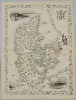
Denmark.
Publicado por John Tallis & Company. [Circa1850s]., London & New York., 1850
Librería: Asia Bookroom ANZAAB/ILAB, Canberra, ACT, Australia
Miembro de asociación: ANZAAB ILAB
Calificación del vendedor: 5 de 5 estrellas
EUR 111,04
Envío por EUR 25,78
Se envía de Australia a Estados Unidos de AmericaCantidad disponible: 1 disponibles
Añadir al carritoLithographed map, with original outline hand colour, 34.5 x 24.7 cm (including border and captions),five fine vignette illustrations, decorative border, central fold, edges with light toning in very good condition. Attractive decorative map with fine vignettes of Copenhagen, Sleswig and Elsinore, figures in costume, the coat of arms of Denmark and an amiable equine pair by the great mapmaker and publisher John Tallis.
-

Denmark, antique map with vignette views
Publicado por John Tallis & Co., London, 1854
Librería: Antipodean Books, Maps & Prints, ABAA, Garrison, NY, Estados Unidos de America
Miembro de asociación: ABAA ANZAAB ESA ILAB
Calificación del vendedor: 3 de 5 estrellas

EUR 146,05
Envío por EUR 8,59
Se envía dentro de Estados Unidos de AmericaCantidad disponible: 1 disponibles
Añadir al carritoMaps. Steel engraved map from the famous Victorian publisher John Tallis, well-known for the attractive vignette views surrounding the maps, which illustrate the peoples & customs of that region. 10 x 13 1/2" plus margins. Attractive decorative border around edge, period outline color, very good condition.
-
Denmark
Publicado por John Tallis, London, 1850
Librería: Alexandre Antique Prints, Maps & Books, Toronto, ON, Canada
Miembro de asociación: ABAC ILAB
Calificación del vendedor: 5 de 5 estrellas
Mapa
EUR 199,16
Envío por EUR 5,16
Se envía de Canada a Estados Unidos de AmericaCantidad disponible: 1 disponibles
Añadir al carritoCondición: Very Good. Size : 330x245 (mm), 13x9.625 (Inches), Original Outline Coloring.
-
Denmark - with Vignettes of Sleswig, Elsinore, and Copenhagen and Depictions of Danish Peasantry.
Publicado por London, Edinburgh & Dublin, J & F. Tallis., 1851
Librería: Inanna Rare Books Ltd., Skibbereen, CORK, Irlanda
Calificación del vendedor: 5 de 5 estrellas
Arte / Grabado / Póster
EUR 275,00
Envío por EUR 28,00
Se envía de Irlanda a Estados Unidos de AmericaCantidad disponible: 1 disponibles
Añadir al carritoOriginal steel engraving / Vintage map. Drawn and engraved by John Rapkin. Partly hand-coloured. Illustrations by H. Warren and engravings by J.B. Allen. Plate Size: 25 cm x 34 cm. Sheet Size: 27.4 cm x 37.4 cm. Vintage 19th century map in very good condition. Published in the Illustrated Atlas, And Modern History Of The World Geographical, Political, Commercial & Statistical, Edited By R. Montgomery Martin. Beautiful and interesting map of Denmark: the Jutland Peninsula and the surrounding islands such as Zealand and Funen in the Baltic and the North Sea. The political subdivisions of Denmark are delineated and the towns and cities, including Copenhagen, Aarhus, and Odense are shown. Off the east coast the Cattegat strait is identified. The southern coast of Sweden is shown as are the German coasts in the lower part of the map (Hanover, Mecklenburg and Prussia) The Danish royal coat-of-arms can be seen in the upper right corner of the map. John Tallis (7 November 1817 3 June 1876) was an English cartographic publisher. His company, John Tallis and Company, published views, maps and atlases in London from roughly 1838 to 1851. Tallis set up as a publisher with Frederick Tallis in Cripplegate in 1842; the business moved to Smithfield in 1846, and was dissolved in 1849. From 1851 to 1854 Tallis operated as John Tallis and Company. He started The illustrated news of the world and national portrait gallery of eminent personages in 1858, selling it for £1,370 in 1861; it folded in 1863. (Wikipedia) The most important project John Tallis undertook, was the 'Illustrated Atlas' from 1851. The original map we offer here, was part of this exceptional Atlas and all the maps it contained are still today considered as the last reminder of an era of lavish map production. Tallis worked the project together with John Rapkin (1815-1876) and it was Rapkin's style and talent that we have to thank for when we marvel at these maps today. What makes these maps so special is the detail of engraved vignettes that surround the map and often show indigenous scenes, people in their environment and even more so, historical buildings or historical views of towns and cities, architecture and landscape. The project of 'The Illustrated Atlas' was designed to be finished just in time for the anxiously awaited "Great Exhibition of the Works of Industry of All Nations" or The Great Exhibition, sometimes referred to as the Crystal Palace Exhibition in reference to the temporary structure in which it was held, was an international exhibition that took place in Hyde Park, London, from 1 May to 11 October 1851. It was the first in a series of World's Fairs, exhibitions of culture and industry that became popular in the 19th century, and it was a much-anticipated event. The Great Exhibition was organized by Henry Cole and Prince Albert, husband of the reigning monarch, Queen Victoria. It was attended by numerous notable figures of the time, including Charles Darwin, Samuel Colt, members of the Orléanist Royal Family and the writers Charlotte Brontë, Charles Dickens, Lewis Carroll, George Eliot and Alfred Tennyson. Music for the opening was under the direction of Sir George Thomas Smart and the continuous music from the exhibited organs for the Queen's procession was "under the superintendence of William Sterndale Bennett". (Wikipedia) Sprache: english.


