
Importe total (1 artículo artículos):
Destino del pedido:

dated events map (14 resultados)
Ir a los resultados principales
Filtros de búsqueda
Tipo de artículo
- Todos los tipos de productos
- Libros (2)
- Revistas y publicaciones (No hay ningún otro resultado que coincida con este filtro.)
- Cómics (No hay ningún otro resultado que coincida con este filtro.)
- Partituras (No hay ningún otro resultado que coincida con este filtro.)
- Arte, grabados y pósters (No hay ningún otro resultado que coincida con este filtro.)
- Fotografías (No hay ningún otro resultado que coincida con este filtro.)
- Mapas (12)
- Manuscritos y coleccionismo de papel (No hay ningún otro resultado que coincida con este filtro.)
Condición Más información
- Nuevo (No hay ningún otro resultado que coincida con este filtro.)
- Como nuevo, Excelente o Muy bueno (2)
- Bueno o Aceptable (2)
- Regular o Pobre (No hay ningún otro resultado que coincida con este filtro.)
- Tal como se indica (10)
Encuadernación
- Todas
- Tapa dura (No hay ningún otro resultado que coincida con este filtro.)
- Tapa blanda (1)
Más atributos
- Primera edición (No hay ningún otro resultado que coincida con este filtro.)
- Firmado (No hay ningún otro resultado que coincida con este filtro.)
- Sobrecubierta (No hay ningún otro resultado que coincida con este filtro.)
- Con imágenes (9)
- No impresión bajo demanda (14)
Idioma (3)
Precio
- Cualquier precio
- Menos de EUR 20 (No hay ningún otro resultado que coincida con este filtro.)
- EUR 20 a EUR 45 (No hay ningún otro resultado que coincida con este filtro.)
- Más de EUR 45
Gastos de envío gratis
- Envío gratis a Estados Unidos de America (No hay ningún otro resultado que coincida con este filtro.)
Ubicación del vendedor
Valoración de los vendedores
-

Dated Events War Map
Idioma: Inglés
Publicado por Shaw-Barton, 1944
Librería: Browse Awhile Books, Tipp City, OH, Estados Unidos de America
Calificación del vendedor: 5 de 5 estrellas

Mapa
EUR 66,49
Envío por EUR 6,03
Se envía dentro de Estados Unidos de AmericaCantidad disponible: 1 disponibles
Ańadir al carritoSoft cover. Condición: Near Fine. Large (38"x17 1/4") fold-out world map, with events of WWII. Fresh, bright and undamaged.
-
Dated Events War Map
Publicado por C. C. Petersen Advertising, Toronto, 1944
Librería: Kestrel Books, Vancouver, BC, Canada
Calificación del vendedor: 5 de 5 estrellas
Mapa
EUR 66,49
Envío por EUR 10,33
Se envía de Canada a Estados Unidos de AmericaCantidad disponible: 1 disponibles
Ańadir al carritoNo Binding. Condición: Very Good. 39x17" colour pictorial map of the world depicting World War II events as of 1944. Very Good with slight wear to folds. RARE.
-

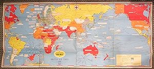
Dated Events War Map. 1945. (Atomic Bomb)
Publicado por Gettier Montanye, 1945
Librería: Sequitur Books, Boonsboro, MD, Estados Unidos de America
Miembro de asociación: IOBA
Calificación del vendedor: 5 de 5 estrellas
Mapa
EUR 159,58
Envío por EUR 4,28
Se envía dentro de Estados Unidos de AmericaCantidad disponible: 1 disponibles
Ańadir al carritoMap. Condición: Good. 28. [Original WWII Map] Not a reproduction. 44 x 99 cm. Folding map. Mercator projection. Full color. V-e Day: May 8, 1945. V-j day, Sept. 2, 1945. Contains extensive list of Dated Events and Roll Call of the United Nations. Includes photographs of Truman, Eisenhower, MacArthur, Pearl Harbor, the Atomic Bomb. Small closed tear at base. Creased at folds.
-
War in Europe - Dated Events Map. 1944
Publicado por C. C. Petersen, Publishing and Advertising, Toronto, Ontario, 1944
Librería: Babylon Revisited Rare Books, Northampton, MA, Estados Unidos de America
Calificación del vendedor: 4 de 5 estrellas

Mapa
EUR 177,31
Envío por EUR 8,61
Se envía dentro de Estados Unidos de AmericaCantidad disponible: 1 disponibles
Ańadir al carrito50.8 x 66.04 cm. Colorful map of World War II with color coding, annotations, and inset maps. Very Good, tiny tears, pin holes at corners, general wear.
-
Map of the World War Fronts / Dated Events
Publicado por Petersen Publishing and Advertising, Toronto, 1943
Librería: Babylon Revisited Rare Books, Northampton, MA, Estados Unidos de America
Calificación del vendedor: 4 de 5 estrellas
Mapa
EUR 265,97
Envío por EUR 8,61
Se envía dentro de Estados Unidos de AmericaCantidad disponible: 1 disponibles
Ańadir al carrito20" x 26.5". Very Good, some signs of wear.
-
Dated Events Invasion Map of Fortress Europe.
Publicado por C.C. Petersen., Toronto., 1944
Librería: Asia Bookroom ANZAAB/ILAB, Canberra, ACT, Australia
Miembro de asociación: ANZAAB ILAB
Calificación del vendedor: 5 de 5 estrellas
EUR 348,54
Envío por EUR 25,82
Se envía de Australia a Estados Unidos de AmericaCantidad disponible: 1 disponibles
Ańadir al carritoColour pictorial map, 51 x 67 cms, two small inset maps of Scandinavia and the Baltic and South Greece and the Dodecanese, on the verso a black and white world map showing the Pacific Theatre marking keys events of the war and in European world history, folding into the original pictorial pocket (a little toned and marked) 25.8 x 17.7 cms, small fold split, but in very good condition. A scarce map in the "Dated Events" series published by C.C. Petersen in Canada, and distributed throughout North America commemorating D-Day. The colour map by Stanley Turner encompasses the area from England as far south as the French border with Spain and as far east as the USSR and Turkey. "With this invasion map you will be able to follow the progress of the Allied troops on their way to smash Germany.". The text at lower left goes on to elaborate on the features shown on the map, from elevation ("major battles are seldom fought on the tops of mountains") to pictographs of bombs falling. The black and white map on the verso shows the Far Eastern theatre of war, centring on the Pacific Ocean with the Asian landmass including India and the USSR at upper left, Australia at lower left and North America and the coast of South America at right of the map. Naval bases are shown and significant events in the war are noted in text boxes. A handsome production of a scarce map rarely seen with the original pictorial pocket.
-
Map of the World War Fronts Dated Events
Publicado por C.C. Petersen Advertising; R.G.McLean Ltd., Toronto, 1944
Librería: Alexandre Antique Prints, Maps & Books, Toronto, ON, Canada
Miembro de asociación: ABAC ILAB
Calificación del vendedor: 5 de 5 estrellas
Mapa
EUR 421,11
Envío por EUR 5,16
Se envía de Canada a Estados Unidos de AmericaCantidad disponible: 1 disponibles
Ańadir al carritoPictorial map of World War II era. , Size : 501x658 (mm), 19.72x25.91 (Inches), Printed in Color Very Good, backed on acid free tissue paper for long term preservation.
-
New Dated Events World War Map Showing All War Areas in Relation to the Americas The Second Front?
Publicado por C.C. Petersen Advertising; R.G.McLean Ltd., Toronto, 1942
Librería: Alexandre Antique Prints, Maps & Books, Toronto, ON, Canada
Miembro de asociación: ABAC ILAB
Calificación del vendedor: 5 de 5 estrellas
Mapa
EUR 421,11
Envío por EUR 5,16
Se envía de Canada a Estados Unidos de AmericaCantidad disponible: 1 disponibles
Ańadir al carritoPictorial and interesting World War II map., Size : 498x657 (mm), 19.61x25.87 (Inches), Printed in Color Very Good, backed on acid free tissue paper for long term preservation.
-
Dated Events World War Map
Publicado por C.C. Petersen Publishing; R.G.McLean Ltd. c.1944, Toronto, 1944
Librería: Alexandre Antique Prints, Maps & Books, Toronto, ON, Canada
Miembro de asociación: ABAC ILAB
Calificación del vendedor: 5 de 5 estrellas
Mapa
EUR 421,11
Envío por EUR 5,16
Se envía de Canada a Estados Unidos de AmericaCantidad disponible: 1 disponibles
Ańadir al carritoA decorative pictorial map of WWII with vivid colours and attractive design showing Europe., Size : 508x664 (mm), 20.00x26.14 (Inches), Printed in Color Very Good, backed on acid free tissue paper for long term preservation.
-

Dated Events Invasion Map of Fortress Europe.
Publicado por Toronto, 1944. 505 x 665mm (20 x 26Ľ inches)., 1944
Librería: Tooley, Adams & Co., Wallingford, OXON, Reino Unido
Calificación del vendedor: 4 de 5 estrellas
EUR 452,51
Envío por EUR 42,95
Se envía de Reino Unido a Estados Unidos de AmericaCantidad disponible: 1 disponibles
Ańadir al carritoColoured lithograph; old folds, some weak at the edges, short tears into folds, otherwise overall very good. Two maps and printed on both sides, on one side a pictorial map of the war situation in Europe 1944 and on the verso a map of eastern Asia, western Americas and the Pacific Ocean. 7th. edition. The map of Europe includes part of Spain up to the British Isles and across to the U.S.S.R. and Turkey. With inset maps of Scandinavia and the islands of Greece. Showing the Anglo-American, Russian and neutral naval bases, Anglo-American battlefields and raids, Russian victories 1943-44 advance, pre-war boundaries, fortified lines and bombed areas, German aircraft production centres, railways, roads, canals, and oil pipe lines. Also includes numerous notes illustrating important events. On the verso: an uncoloured map showing the Naval bases, British, American, Russian and Japanese, and historical information during World War II in the Pacific, Arctic and Indian Oceans.
-

Dated Events. On to Tokyo. Invasion Map of the Pacific and the Far East. Eighth Edition. / War in Europe. Dated Events.
Ańo de publicación: 1944
Librería: Geographicus Rare Antique Maps, Brooklyn, NY, Estados Unidos de America
Miembro de asociación: ABAA ESA ILAB
Calificación del vendedor: 4 de 5 estrellas
Mapa
EUR 422,00
Envío por EUR 14,63
Se envía dentro de Estados Unidos de AmericaCantidad disponible: 1 disponibles
Ańadir al carritoGood. Wear along original fold lines. Verso repair to a fold separation. Pinholing in corners and along sides. Dated Events Map of Europe on verso. Size 20 x 26 Inches. This is a Stanley Francis Turner map of the Pacific Theater of World War II (1939 - 1945), published in late October or early November 1944. As with Turner's other World War II maps, short text boxes highlight important events during the war up to publication, in this case from the Japanese attack on Pearl Harbor on December 7, 1941, until the U.S. invasion of the Philippines on October 17, 1944. A Closer Look - World War II in the Pacific Depicting from central India to Hawaii and from the Soviet Union and Alaska to northern Australia, Turner highlights Allied victories and Japanese expansion across the Pacific (including Corregidor, Bataan, and Guam). Text boxes inform on Japanese incursions into Manchuria, China, and French Indochina, as well as their alliance with the Axis. The Battle of Midway, Battle of the Coral Sea, and Battle of the Solomons are referenced by name. Red illustrates areas of under Allied control (India, Australia, and part of New Guinea). Pink, which colors the rest of New Guinea, part of New Britain, and most of the Solomon Islands, shades territory that has been retaken from the Japanese, and orange areas represent territory occupied by the Japanese. Verso Content: Dated Events War Map of Europe An edition of Turner's Dated Events War Map of Europe occupies the verso. This map is not as up to date as the recto map of the Pacific. Major events from 1944, including the D-Day landings, are not included, not to mention the complete lack of information concerning the 1943 invasion of Sicily. Intriguingly, other important events from 1943 do appear, including the Tehran Conference between Roosevelt, Churchill, and Stalin. The list of events on the Eastern Front (labeled 'The Great Russian Offensive') also includes events through the end of October 1943. Two polar inset maps occupy the upper corners. Publication History and Census This map was created by Stanley Francis Turner and published by C. C. Peterson in 1944. We note a single example cataloged in OCLC: University of Minnesota Twin Cities, and another with the David Rumsey Map Collection. References: Rumsey 10010.001. OCLC 613361665.
-

Dated Events War Map of the Pacific and Far East.
Ańo de publicación: 1942
Librería: Geographicus Rare Antique Maps, Brooklyn, NY, Estados Unidos de America
Miembro de asociación: ABAA ESA ILAB
Calificación del vendedor: 4 de 5 estrellas
Mapa
EUR 446,82
Envío por EUR 14,63
Se envía dentro de Estados Unidos de AmericaCantidad disponible: 1 disponibles
Ańadir al carritoVery good. Light wear along original fold lines. Light creasing. Size 19.75 x 26.125 Inches. This is a January 1942 Stanley Francis Turner Dated Events War Map of the Pacific and East Asia , published less than a month after the Japanese attack on Pearl Harbor. Turner produced the 'Dated Events War Map' series throughout World War II (1939 - 1945), creating more than 25 maps, which, as a whole, present a comprehensive cartographic overview of war events as they unfolded. The present map is the Second Edition, the earliest 'Dated War Events' map we have encountered - we've never seen the first issue. A Closer Look Coverage embraces from Lhasa, Tibet, and Rangoon, Burma (now Yangon) to Reykjavik, Iceland, and from the Arctic Circle to Cape Horn. Black textboxes mark events in the Pacific War from August 1940 (August 20, 1940, U.S.A. leases British ports for joint defense) through January 1942 (January 4, 1942, Chinese victory at Changsha). Most of the referenced events postdate the December 7, 1941, Japanese attack on Pearl Harbor. Earlier events include Japan joining the Axis (September 27, 1940), President Franklin D. Roosevelt signing the Lend-Lease Act (March 11, 1941), and the Vichy French surrender of Indochina to the Japanese (July 24, 1941). American, British, Dutch, French, Japanese, and Russian naval bases are marked using specific symbols for each nation. Illustrations of warships and military airplanes fill the Pacific. Color is used to highlight parts of the world under the direct control of the Americans (orange), British (red), and Japanese (black for the Home Islands and Korea and green for the occupied territory, including Manchukuo and French Indochina). Flags also help identify which country controls which territory. Aside from war-related content, cities and towns fill the map. The map also references natural resources key to the war effort, including oil, rubber, iron, copper, manganese, rice, and tea. Three insets appear along the bottom border: British India, a world map, and the transatlantic route between Natal, Brazil, and Dakar, French West Africa (now Senegal). Publication History and Census This map was created by Stanley Francis Turner, printed by R. G. McLean Limited, and published in 1942 by C.C. Petersen. We note 2 examples cataloged in OCLC: University of Houston and the University of Wyoming. An example is also part of the David Rumsey Map Collection. It ranks among the scarcest of Turner's Dated Events maps. This is the first time we have handled an example. References: Rumsey 10407.000. OCLC 48181730.
-
Dated Events Map of World Conquests Showing Axis Attempt at World Conquest.
Ańo de publicación: 1944
Librería: Geographicus Rare Antique Maps, Brooklyn, NY, Estados Unidos de America
Miembro de asociación: ABAA ESA ILAB
Calificación del vendedor: 3 de 5 estrellas

Mapa
EUR 645,41
Envío por EUR 14,63
Se envía dentro de Estados Unidos de AmericaCantidad disponible: 1 disponibles
Ańadir al carritoGood. Light wear along original fold lines. Verso repairs to fold separations. Closed tear extending 3.25 inches into printed area from bottom border to the right of the South Africa inset. Size 17 x 38.5 Inches. This 1944 Stanley Francis Turner map of Europe, Africa, and Asia illustrates the world on the eve of 1945, the final year of World War II (1939 - 1945). Text boxes scattered throughout chronicle important wartime events, including the D-Day invasion of France, the liberation of Paris, and MacArthur's return to the Philippines, along with numerous others. The United Nations are shaded red, while land controlled by the Axis is green. Light green areas (limited to Asia only) illustrate conquered areas still controlled by the Axis. Countries are labeled and bear their flag, while world capitals are marked by yellow banners and small icons of buildings. Illustrations of airplanes and warships dot the map. Aerial distance charts to Berlin and Tokyo also appear. A small inset along the bottom border illustrates southern Africa and Madagascar and uses the same color scheme to portray alliances. Empire Insets Six insets (five along the left side and one in the upper right corner) illustrate the greatest extent of six historic empires. These are the Persian Empire, the Empire of Alexander the Great, the Roman Empire, the Conquests of Islam, Napoleon's conquests in Europe, and Genghis Khan's conquests in Asia. Each inset features a portrait of the empire's leader and a short, simple history of each empire. Sponsored by Lipton Tea! Turner's wartime maps, with very few exceptions, were distributed by companies to their clients. The present example was 'Published with the Compliments of Thomas J. Lipton Limited, Toronto'. Publication History and Census This map was created by Stanley Francis Turner and publisher by C. C. Peterson in 1944. We note only one other cataloged example of this edition. It appears in OCLC and it is part of the collection at the University of Toronto. A second edition, the 'Victory Edition' is part of the David Rumsey Map Collection. References: OCLC 884019825.
-
Dated Events War Map. 1945. (Atomic Bomb)
Idioma: Griego Moderno
Ańo de publicación: 1942
Librería: Engel Books, Seattle, WA, Estados Unidos de America
Calificación del vendedor: 4 de 5 estrellas
Mapa
EUR 443,28
Envío por EUR 4,30
Se envía dentro de Estados Unidos de AmericaCantidad disponible: 1 disponibles
Ańadir al carritoNo Binding. Condición: Near Fine. Colorful Map Celebrates the end of World War II in both Europe and the Pacific - includes black & white photos of: flag raising on Iwo Jima, atomic bomb. Pearl Harbor, Eisenhower & MacArthur28th Edition- Obviously after 1945 (copyright dated 1942) 17.25 x 38.75 in. In excellent condition with one .25" tear on bottom & slightest edge rubbing. Compliments of Marigold Dairies, Inc. Blank on Verso. Some rubbing at original folds but overall clean & bright. In closed plastic bag for many years. from private WW2 collection. Additional Photos gladly provided.


