
Importe total (1 artículo artículos):
Destino del pedido:

county map state maine (33 resultados)
Ir a los resultados principales
Filtros de búsqueda
Tipo de artículo
- Todos los tipos de productos
- Libros (25)
- Revistas y publicaciones (No hay ningún otro resultado que coincida con este filtro.)
- Cómics (No hay ningún otro resultado que coincida con este filtro.)
- Partituras (No hay ningún otro resultado que coincida con este filtro.)
- Arte, grabados y pósters (1)
- Fotografías (No hay ningún otro resultado que coincida con este filtro.)
- Mapas (7)
- Manuscritos y coleccionismo de papel (No hay ningún otro resultado que coincida con este filtro.)
Condición Más información
- Nuevo (No hay ningún otro resultado que coincida con este filtro.)
- Como nuevo, Excelente o Muy bueno (3)
- Bueno o Aceptable (2)
- Regular o Pobre (No hay ningún otro resultado que coincida con este filtro.)
- Tal como se indica (28)
Encuadernación
- Todas
- Tapa dura (No hay ningún otro resultado que coincida con este filtro.)
- Tapa blanda (No hay ningún otro resultado que coincida con este filtro.)
Más atributos
- Primera edición (No hay ningún otro resultado que coincida con este filtro.)
- Firmado (No hay ningún otro resultado que coincida con este filtro.)
- Sobrecubierta (No hay ningún otro resultado que coincida con este filtro.)
- Con imágenes (27)
- No impresión bajo demanda (33)
Idioma (2)
Gastos de envío gratis
- Envío gratis a Estados Unidos de America (No hay ningún otro resultado que coincida con este filtro.)
Ubicación del vendedor
Valoración de los vendedores
-

Map of the Region Near Kidney Pond in Piscataquis County and the State of Maine. Compiled from the Maps of the Appalachian Club and from Other Data by H. M. Knickerbocker and J. W. Worthington. (1943) 1960 EDITION
Idioma: Inglés
Publicado por Unknown, 1960
Librería: White Mountains, NH Books and Maps, Lincoln, NH, Estados Unidos de America
Calificación del vendedor: 5 de 5 estrellas

EUR 17,25
Envío por EUR 6,89
Se envía dentro de Estados Unidos de AmericaCantidad disponible: 1 disponibles
Ańadir al carritoNo Binding. Condición: Near Fine. Knickerbocker, H. M. & J. W. Worthington Ilustrador. Original map dated 1943 (1960 Edition) With 2 fold creases, presumed as issued. SMALL CHIP UPPER RIGHT-HAND CORNER.
-
Map of the Region Near Kidney Pond in Piscataquis County and the State of Maine. Compiled from the Maps of the Appalachian Club and from Other Data by H. M. Knickerbocker and J. W. Worthington. (1943) 1960 EDITION
Idioma: Inglés
Publicado por Unknown, 1960
Librería: White Mountains, NH Books and Maps, Lincoln, NH, Estados Unidos de America
Calificación del vendedor: 5 de 5 estrellas
EUR 25,88
Envío por EUR 6,89
Se envía dentro de Estados Unidos de AmericaCantidad disponible: 1 disponibles
Ańadir al carritoNo Binding. Condición: Near Fine. Knickerbocker, H. M. & J. W. Worthington Ilustrador. Original map dated 1943 (1960 Edition) With 2 fold creases, presumed as issued.
-

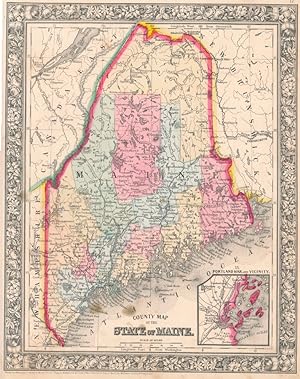
County ty Map of the State of Maine
Publicado por S, Augustus Mitchell, Philadelphia, 1879
Librería: mediumraremaps.com, Franklin, TN, Estados Unidos de America
Calificación del vendedor: 4 de 5 estrellas

Mapa
EUR 39,90
Envío por EUR 5,16
Se envía dentro de Estados Unidos de AmericaCantidad disponible: 1 disponibles
Ańadir al carrito12 1/2 x 10 3/4 inches. A later edition of Mitchell's map of Maine on the eve of the Bradley acquisition of the enterprise. Pleasant grape vine boarders frame out this map and its inset of Portland Harbor. It would look very nice framed and on the wall. Transportation by water or rail made for a thriving commercial landscape. Vast amounts of fishing spaces and inland forest made Maine and important supply point for the New England states. Good with tears expertly repaired with archival mending tape.
-

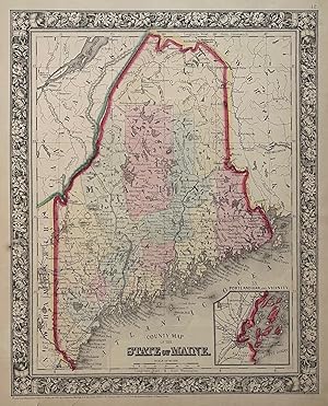
County Map of the State of Maine
Publicado por S. Augustus Mitchell, Philadelphia, 1872
Librería: mediumraremaps.com, Franklin, TN, Estados Unidos de America
Calificación del vendedor: 4 de 5 estrellas
Mapa
EUR 44,33
Envío por EUR 5,16
Se envía dentro de Estados Unidos de AmericaCantidad disponible: 1 disponibles
Ańadir al carrito13 3/4 x 10 3/4 inches. Condición: Very good. Well copied rendering of the State of Maine with an inset of Portland Harbor and Vicinity. Lightly colored counties backdrop a most interesting picture of a maritime state with vast areas of native forests. Several railroads are in place giving a feeling for the local transportation picture at 1872.
-
Maine state by itself 1894 Smith hand color large County Map
Ańo de publicación: 1894
Librería: RareMapsandBooks, Dover, NH, Estados Unidos de America
Miembro de asociación: ESA IOBA
Calificación del vendedor: 5 de 5 estrellas
Mapa
EUR 26,60
Envío por EUR 5,98
Se envía dentro de Estados Unidos de AmericaCantidad disponible: 1 disponibles
Ańadir al carritoCondición: good. County and Township Map of the State of Maine.(Old Maps, 19th Century Maps, Americana, United States, New England, Maine, Portland, Augusta, Bangor, Mt. Desert Island). Issued 1894, Philadelphia by A. L. Smith. Late 19th century lithographed map with original hand color. Well preserved, nice looking example with pleasing age patina. Original center fold as issued. Sheet Measures c. 23 1/2" H x 14 3/4" W. Engraved Area Measures c. 20" H x 13" W. Cartographic Reference (s):Tooley's Dictionary of Mapmakers, vol. 4.[R35917].
-
Map of the Region Near Kidney Pond in Piscataquis County and the State of Maine. Compiled from the Maps of the Appalachian Club and from Other Data by H. M. Knickerbocker and J. W. Worthington. 1943
Idioma: Inglés
Publicado por Unknown, 1943
Librería: White Mountains, NH Books and Maps, Lincoln, NH, Estados Unidos de America
Calificación del vendedor: 5 de 5 estrellas
EUR 107,83
Envío por EUR 6,89
Se envía dentro de Estados Unidos de AmericaCantidad disponible: 1 disponibles
Ańadir al carritoNo Binding. Condición: Near Fine. Knickerbocker, H. M. & J. W. Worthington Ilustrador. Scarce Original map dated 1943 (later ones were designated 19xx EDITION in the lower left corner) printed on 'Weston's Bond' watermarked paper. Measures 9 1/8" x 10 7/8" (8 5/8" x 10 1/8" + margins).
-
County Map of the State of Maine
Publicado por S. Augustus Mitchell, Jr., New York, 1860
Librería: Main Street Fine Books & Mss, ABAA, Galena, IL, Estados Unidos de America
Miembro de asociación: ABAA ILAB MWABA
Calificación del vendedor: 5 de 5 estrellas
Mapa
EUR 66,49
Envío por EUR 5,16
Se envía dentro de Estados Unidos de AmericaCantidad disponible: 1 disponibles
Ańadir al carritoFolio (12Ľ" X 15Ľ", image area 10˝" X 15˝"). Hand colored. Very good. Light age toning and mild soiling, mainly about edges. Sweet map of the "Pine Tree State," nicely hand-colored, from the 1864 edition of "Mitchell's New General Atlas, Containing Maps of the Various Countries of the World, Plans of Cities, Etc." Inset at lower right features "Portland Har. and Vicinity." Attractive example, with sharp colors and handsome decorative border.
-
County Map of the State of Maine.
Publicado por Philadelphia:, 1870
Librería: Nicholas D. Riccio Rare Books, ABAA, Florham Park, NJ, Estados Unidos de America
Miembro de asociación: ABAA ILAB
Calificación del vendedor: 4 de 5 estrellas
EUR 66,49
Envío por EUR 6,89
Se envía dentro de Estados Unidos de AmericaCantidad disponible: 1 disponibles
Ańadir al carritoUnbound, colored engraved map, decorative boarder, 14"x 11". Slight toning and aging; bright and clear, and in otherwise very good shape. Maps are wrapped with acid free board, or in rigid sleeves. The Mitchell family started to produce atlases in 1846, and continued into the early 1890s. Around 1860, S. Augustus Mitchell Jr. took over, and the atlas would be called Mitchell's New General Atlas. This is an attractive colorful single page map of Maine from the 1870 installment of that atlas. Good detail, and Portland is featured in an inset. Ristow 311-313.
-

County Map 0f the State of Maine
Publicado por Philadelphia, 1869
Librería: Nicholas D. Riccio Rare Books, ABAA, Florham Park, NJ, Estados Unidos de America
Miembro de asociación: ABAA ILAB
Calificación del vendedor: 4 de 5 estrellas
EUR 66,49
Envío por EUR 6,89
Se envía dentro de Estados Unidos de AmericaCantidad disponible: 1 disponibles
Ańadir al carritoPhiladelphia, 1869. Unbound, colored engraved map, decorative boarder, 14"x 11". Slight toning and aging; bright and clear, and in otherwise very good shape. Maps are wrapped with acid free board, or in rigid sleeves. The Mitchell family started to produce atlases in 1846, and continued into the early 1890s. Around 1860, S. Augustus Mitchell Jr. took over, and the atlas would be called Mitchell's New General Atlas. This is an attractive colorful single page map of Maine from the 1869 installment of that atlas. Good detail, and Portland is featured in an inset. Ristow 311-313.
-
County Map 0f the State of Maine
Publicado por Philadelphia, 1882
Librería: Nicholas D. Riccio Rare Books, ABAA, Florham Park, NJ, Estados Unidos de America
Miembro de asociación: ABAA ILAB
Calificación del vendedor: 4 de 5 estrellas
EUR 66,49
Envío por EUR 6,89
Se envía dentro de Estados Unidos de AmericaCantidad disponible: 1 disponibles
Ańadir al carritoPhiladelphia, 1882. Unbound, colored engraved map, decorative boarder, 14"x 11". Slight toning and aging, minor soiling and acople of small nicks ta side edge; still bright and clear, and in otherwise very good shape. Maps are wrapped with acid free board, or in rigid sleeves. The Mitchell family started to produce atlases in 1846, and continued into the early 1890s. Around 1860, S. Augustus Mitchell Jr. took over, and the atlas would be called Mitchell's New General Atlas. This is an attractive colorful single page map of Maine from the 1869 installment of that atlas. Good detail, and Portland is featured in an inset. Ristow 311-313.
-

1862 County Map of the State of Maine
Librería: New World Cartographic, Chicago, IL, Estados Unidos de America
Miembro de asociación: ABAA ILAB
Calificación del vendedor: 4 de 5 estrellas
Mapa
EUR 57,63
Envío por EUR 2,58
Se envía dentro de Estados Unidos de AmericaCantidad disponible: 1 disponibles
Ańadir al carritoBy: Samuel A. Mitchell Jr.Date: 1862 (published) PhiladelphiaDimensions: 13.25 x 10.5 inches (33.7 x 26.7 cm)This is an authentic, antique lithograph map of Maine by Samuel Augustus Mitchell Jr. The map was published in Philadelphia as part of Mitchells New General Atlas of 1862. It is color coded by county and important travel routes, towns, and cities throughout. A small inset of Portland Harbor can be found in the lower right corner. The map is surrounded by an elaborate floral boarder that distinguished Mitchell's works from other map makers of his era.Condition: Map is in A condition showing a fine printing with bold original color on clean paper.Inventory #111381200 W. 35th Street #425 Chicago, IL 60609 | P: (312) 496 - 3622.
-

County Map of the State of Maine
Publicado por S. Augustus Mitchell, Jr., New York, 1860
Librería: Main Street Fine Books & Mss, ABAA, Galena, IL, Estados Unidos de America
Miembro de asociación: ABAA ILAB MWABA
Calificación del vendedor: 5 de 5 estrellas
Mapa
EUR 84,22
Envío por EUR 5,16
Se envía dentro de Estados Unidos de AmericaCantidad disponible: 1 disponibles
Ańadir al carritoFolio (12Ľ" X 15Ľ", image area 10˝" X 15˝"). Hand colored. Very good. Mild age toning only. Charming hand-colored map of Maine, from the 1864 edition of "Mitchell's New General Atlas, Containing Maps of the Various Countries of the World, Plans of Cities, Etc." Inset at lower right features "Portland Har. and Vicinity." A lovely example, well colored and with handsome decorative border.
-

County and Township Map of the State of Maine
Ańo de publicación: 1887
Librería: Art Source International Inc., Boulder, CO, Estados Unidos de America
Calificación del vendedor: 5 de 5 estrellas
EUR 48,76
Envío por EUR 13,77
Se envía dentro de Estados Unidos de AmericaCantidad disponible: 1 disponibles
Ańadir al carritoThis map was made by S. Augustus Mitchell for "Mitchell's New General Atlas" published in 1887. The well maintained maps in this atlas feature Mitchell's characteristic pastel coloring and abundant details of geographical features. Maine is illustrated on this map. Details include the names of counties, important towns, rivers, mountains, lakes, and railroads. Counties are distinguished by color. These 1887 maps offer a fascinating perspective of areas that have since undergone significant growth and change, in addition to their value as great examples of Mitchell's work. This map measures 15 inches by 21.5 inches.
-

County & Township Map of the State of Maine
Ańo de publicación: 1884
Librería: Art Source International Inc., Boulder, CO, Estados Unidos de America
Calificación del vendedor: 5 de 5 estrellas
EUR 48,76
Envío por EUR 13,77
Se envía dentro de Estados Unidos de AmericaCantidad disponible: 2 disponibles
Ańadir al carritoThis map was made by S. Augustus Mitchell for "Mitchells New General Atlas" published in 1884, by WM. M. Bradley & Co. The well maintained maps in this atlas feature Mitchell's characteristic pastel coloring and abundant geographical features. Details include the names of counties, cities, towns, transportation routes, rivers, lakes, and mountain ranges. Regions are distinguished by color. These 1884 maps offer a fascinating perspective of areas that have since undergone significant growth and change, in addition to their value as great examples of Mitchell's work. This map measures 15 inches by 21 inches.
-

County Map of the State of Maine
Ańo de publicación: 1870
Librería: Art Source International Inc., Boulder, CO, Estados Unidos de America
Calificación del vendedor: 5 de 5 estrellas
EUR 57,63
Envío por EUR 13,77
Se envía dentro de Estados Unidos de AmericaCantidad disponible: 3 disponibles
Ańadir al carritoS. Augustus Mitchell,Jr. made this hand colored map for Mitchells New General Atlas in 1870. Maine is illustrated on this map. An inset shows the vicinity of Portland Harbor. Counties are distinguished by bright pastel colors. Other details include the names of counties, important cities, railroads, proposed railroads, and major roads. This map measures 10.75 inches by 13.25 inches.
-

County Map of the State of Maine
Ańo de publicación: 1877
Librería: Art Source International Inc., Boulder, CO, Estados Unidos de America
Calificación del vendedor: 5 de 5 estrellas
EUR 57,63
Envío por EUR 13,77
Se envía dentro de Estados Unidos de AmericaCantidad disponible: 3 disponibles
Ańadir al carritoThis hand colored map was made for "Mitchells New General Atlas" published in 1877 by S. Augustus Mitchell. Maine is illustrated on this map. Counties are highlighted by color. An inset shows Portland Harbor and vicinity at a greater scale than the main map. Other details include the names of counties and important cities, and illustrations of rivers, lakes, and major roads. This map measures 10.5 inches by 13.5 inches.
-

County Map of the State of Maine, with Inset of Portland Harbor
Ańo de publicación: 1875
Librería: Art Source International Inc., Boulder, CO, Estados Unidos de America
Calificación del vendedor: 5 de 5 estrellas
EUR 57,63
Envío por EUR 13,77
Se envía dentro de Estados Unidos de AmericaCantidad disponible: 3 disponibles
Ańadir al carritoThis map was produced by S. Augustus Mitchell in 1875 for his New General Atlas. This map shows Mitchells traditional grape vine border, characteristic pastel coloring and abundant details of geographical features. Counties are distinguished by different colors. Wagon trails and major routes of transport are also shown. These 1875 maps offer a fascinating perspective of areas that have since undergone significant growth and change, in addition to their value as great examples of Mitchell's work. This map measures 10.5 inches by 13.5 inches.
-

County and Township Map of the State of Maine
Ańo de publicación: 1888
Librería: Art Source International Inc., Boulder, CO, Estados Unidos de America
Calificación del vendedor: 5 de 5 estrellas
EUR 57,63
Envío por EUR 13,77
Se envía dentro de Estados Unidos de AmericaCantidad disponible: 2 disponibles
Ańadir al carritoThis map of Maine was made by S. Augustus Mitchell for "Mitchells New General Atlas" published in 1888, by WM. M. Bradley & Co. The well maintained maps in this atlas feature Mitchell's characteristic pastel coloring and abundant details of geographical features. Details include the names of counties, cities, towns, transportation routes, mountain ranges, rivers and lakes. These 1888 maps offer a fascinating perspective of areas that have since undergone significant growth and change, in addition to their value as great examples of Mitchell's work. This map measures 14.5 inches by 21.5 inches.
-

County Map of the State of Maine
Ańo de publicación: 1878
Librería: Art Source International Inc., Boulder, CO, Estados Unidos de America
Calificación del vendedor: 5 de 5 estrellas
EUR 57,63
Envío por EUR 13,77
Se envía dentro de Estados Unidos de AmericaCantidad disponible: 1 disponibles
Ańadir al carritoThis map was produced by Augustus Mitchell in 1878 for his New General Atlas. Highlights of this map are Mitchells traditional grapevine border, characteristic pastel coloring and abundant details of geographical features. This county map of the state of Maine includes an inset of Portland Harbor. Towns and counties are distinguished by color. This 1878 map offers a fascinating perspective of areas that have since undergone significant growth and change, in addition to the value as great examples of Mitchell's classic mapmaking style. This map measures 10.5 inches by 13.33 inches.
-

County Map of the State of Maine
Ańo de publicación: 1879
Librería: Art Source International Inc., Boulder, CO, Estados Unidos de America
Calificación del vendedor: 5 de 5 estrellas
EUR 57,63
Envío por EUR 13,77
Se envía dentro de Estados Unidos de AmericaCantidad disponible: 1 disponibles
Ańadir al carritoThis map of Maine was produced by Augustus Mitchell in 1879 for his New General Atlas. Highlights of this map are Mitchells traditional grapevine border, characteristic pastel coloring and abundant details of geographical features. This 1879 map offers a fascinating perspective of areas that have since undergone significant growth and change, in addition to the value as great examples of Mitchell's classic map-making style. This map measures 10.75 inches by 13.5 inches.
-
County Map of the State of Maine
Publicado por Mitchell, Samuel Augustus Jr., Philadelphia, 1860
Librería: Argosy Book Store, ABAA, ILAB, New York, NY, Estados Unidos de America
Miembro de asociación: ABAA ILAB
Calificación del vendedor: 5 de 5 estrellas
EUR 110,82
Envío por EUR 5,16
Se envía dentro de Estados Unidos de AmericaCantidad disponible: 1 disponibles
Ańadir al carritounbound. Map. Steel engraving with original hand coloring. Image measures 13 3/8" x 10 5/8". Lovely map of Maine published in 1860 divided into counties. Shows major towns and cities, routes, railroads and waterways. Features an inset of Portland Harbor. In excellent condition, with a minor chip to lower margin not affecting the image. Samuel Augustus Mitchell Sr. (1792-1868) was one of the leaders in American cartography of the 19th century and pioneered the conversion of engraved map plates to more affordable lithographic plates. His son, Samuel Augustus Mitchell Jr. continued his father's successful mapmaking and publishing business, and was one of the most prolific and renowned 19th century American publishers.
-

County Map of the State of Maine
Ańo de publicación: 1872
Librería: Art Source International Inc., Boulder, CO, Estados Unidos de America
Calificación del vendedor: 5 de 5 estrellas
EUR 62,06
Envío por EUR 13,77
Se envía dentro de Estados Unidos de AmericaCantidad disponible: 3 disponibles
Ańadir al carritoThis state map was made my S. Augustus Mitchell in 1872. The traditional ivy border, and hand coloring make this map beautiful. This US State map shows transportation routes, rivers, towns, and topography features. Counties are distinguished by various pastel colors. Very Detailed! This map measures 10.5 inches by 13.5 inches.
-

County Map of the State of Maine, 1881
Ańo de publicación: 1881
Librería: Art Source International Inc., Boulder, CO, Estados Unidos de America
Calificación del vendedor: 5 de 5 estrellas
EUR 62,06
Envío por EUR 13,77
Se envía dentro de Estados Unidos de AmericaCantidad disponible: 2 disponibles
Ańadir al carritoThis map came from Mitchells New General Atlas, 1881. The traditional ivy border, and hand coloring make this map beautiful. This US State map shows transportation routes, rivers, towns, and topography features. Very Detailed! Includes and inset map of Portland Harbor and Vicinity. This map measures 10.5 inches by 13.5 inches.
-
County Map of The State of Maine.
Publicado por Philadelphia,, 1867
Librería: libreria antiquaria perini Sas di Perini, Verona, VR, Italia
Miembro de asociación: ALAI ILAB
Calificación del vendedor: 5 de 5 estrellas
Arte / Grabado / Póster
EUR 100,00
Envío por EUR 40,00
Se envía de Italia a Estados Unidos de AmericaCantidad disponible: 1 disponibles
Ańadir al carritoIncisione in acciaio, dipinta d'epoca a tutto campo, 290x355. entro bordura decorativa con vitigno intrecciato. Buon esemplare ben conservato, minime macchie marginali e numero 18 manoscritto a inchiostro bruno con lievi aloni agli angoli inferiori e antica numerazione a inchiostro all' angolo inferiore di destra.
-

County map of the State of Maine, 1874
Ańo de publicación: 1874
Librería: Art Source International Inc., Boulder, CO, Estados Unidos de America
Calificación del vendedor: 5 de 5 estrellas
EUR 66,49
Envío por EUR 13,77
Se envía dentro de Estados Unidos de AmericaCantidad disponible: 2 disponibles
Ańadir al carritoThis map was produced by S. Augustus Mitchell in 1874 for his New General Atlas. This map shows Mitchell's traditional grape vine border, characteristic pastel coloring and abundant details of geographical features. The State of Maine is illustrated on this map. Counties are distinguished by color. These 1874 maps offer a fascinating perspective of areas that have since undergone significant growth and change, in addition to their value as great examples of Mitchell's work This map measures 11.5 inches by 14 inches.
-

County Map of the State of Maine
Ańo de publicación: 1867
Librería: Art Source International Inc., Boulder, CO, Estados Unidos de America
Calificación del vendedor: 5 de 5 estrellas
EUR 66,49
Envío por EUR 13,77
Se envía dentro de Estados Unidos de AmericaCantidad disponible: 1 disponibles
Ańadir al carritoThe Mitchell company was one of the first to try out the new technique of engraving on steel plates, experimenting with steel almost 20 years before the rest of the publishing industry. He was printing with steel in the early 1830s; the general switch to steel was approximately 1850. During the early years of the company, Mitchell published mainly maps and travel guides. In 1860, Mitchell started producing "Mitchell's New General Atlas",and Mitchell Sr. retired and turned the business over to his son of the same name. The New General Atlas was published until 1893. Today Mitchell maps are sought after for their fine engraving, bright coloring, and attention to detail. They are some of the finest maps produced in the 1860's. This map produced in 1867, has Mitchell's unique floral border, and beautiful hand coloring. This map details the state of Maine with an inset map of Portland Harbor and vicinity. Counties, cities, towns, transportation routes are noted. This map measures 10.5 inches by 13.5 inches.
-

County Map of the State of Maine
Ańo de publicación: 1866
Librería: Art Source International Inc., Boulder, CO, Estados Unidos de America
Calificación del vendedor: 5 de 5 estrellas
EUR 66,49
Envío por EUR 13,77
Se envía dentro de Estados Unidos de AmericaCantidad disponible: 2 disponibles
Ańadir al carritoThe Mitchell company was one of the first to try out the new technique of engraving on steel plates experimenting with steel almost 20 years before the rest of the publishing industry. He was printing with steel in the early 1830s; the general switch to steel was approximately 1850. During the early years of the company, Mitchell published mainly maps and travel guides. In 1860, Mitchell started producing "Mitchell's New General Atlas",and Mitchell Sr. retired and turned the business over to his son of the same name. The New General Atlas was published until 1893. Today Mitchell maps are sought after for their fine engraving, bright coloring, and attention to detail. They are some of the finest maps produced during this time period. This map produced in 1866, has Mitchell's unique floral border, and beautiful hand coloring. This map details the State of Maine. Counties, cities, towns, lakes, rivers, mountains, and transportation routes are noted. Each map was printed on thick paper with vibrant hand color. This map measures 10.5 inches by 13.25 inches.
-

County Map of the State of Maine, 1863
Ańo de publicación: 1863
Librería: Art Source International Inc., Boulder, CO, Estados Unidos de America
Calificación del vendedor: 5 de 5 estrellas
EUR 66,49
Envío por EUR 13,77
Se envía dentro de Estados Unidos de AmericaCantidad disponible: 2 disponibles
Ańadir al carritoThe Mitchell company was one of the first to try out the new technique of engraving on steel plates, experimenting with steel almost 20 years before the rest of the publishing industry. He was printing with steel in the early 1830s; the general switch to steel engraving was approximately 1850. During the early years of the company, Mitchell published mainly maps and travel guides. In 1860, Mitchell started producing "Mitchell's New General Atlas". Mitchell Sr. retired and turned the business over to his son of the same name. The New General Atlas was published until 1893. Today Mitchell maps are sought after for their fine engraving, bright coloring, and attention to detail. They are some of the finest maps produced in the 1860's.This map produced in 1864, shows Mitchell's famous flower border, which is only seen in the early editions of his atlases. This map shows Maine. This map measures 11 inches by 14 inches.
-

County Map of the State of Maine
Ańo de publicación: 1868
Librería: Art Source International Inc., Boulder, CO, Estados Unidos de America
Calificación del vendedor: 5 de 5 estrellas
EUR 66,49
Envío por EUR 13,77
Se envía dentro de Estados Unidos de AmericaCantidad disponible: 2 disponibles
Ańadir al carritoThis hand colored map was made for "Mitchells New General Atlas" published in 1868 by S. Augustus Mitchell, Jr. Maine is illustrated on this map. An inset shows Portland Harbor at a greater scale than the main map. Counties are distinguished by color. Other details include the names of counties, and important cities, railroads, major roads,and rivers. The pastel coloring in this atlas is very beautiful and more muted than typical. This map measures 10.75 inches by 13.25 inches.
-

County Map of the State of Maine
Ańo de publicación: 1864
Librería: Art Source International Inc., Boulder, CO, Estados Unidos de America
Calificación del vendedor: 5 de 5 estrellas
EUR 70,92
Envío por EUR 13,77
Se envía dentro de Estados Unidos de AmericaCantidad disponible: 1 disponibles
Ańadir al carritoWith characteristic floral boarders and beautiful, muted pastel coloring, these 1864 maps are fantastic examples of Mitchells work. Counties, important cities, mountain ranges, rivers, lakes, and railroads are identified. This hand colored map illustrates the state of Maine with an inset of the vicinity of Portland Harbor. This map measures 10.75 inches by 13.25 inches.

