
Importe total (1 artículo artículos):
Destino del pedido:

chicago de augustus mitchell (18 resultados)
Ir a los resultados principales
Filtros de búsqueda
Tipo de artículo
- Todos los tipos de productos
- Libros (11)
- Revistas y publicaciones (No hay ningún otro resultado que coincida con este filtro.)
- Cómics (No hay ningún otro resultado que coincida con este filtro.)
- Partituras (No hay ningún otro resultado que coincida con este filtro.)
- Arte, grabados y pósters (1)
- Fotografías (No hay ningún otro resultado que coincida con este filtro.)
- Mapas (6)
- Manuscritos y coleccionismo de papel (No hay ningún otro resultado que coincida con este filtro.)
Condición Más información
- Nuevo (No hay ningún otro resultado que coincida con este filtro.)
- Como nuevo, Excelente o Muy bueno (No hay ningún otro resultado que coincida con este filtro.)
- Bueno o Aceptable (4)
- Regular o Pobre (No hay ningún otro resultado que coincida con este filtro.)
- Tal como se indica (14)
Encuadernación
- Todas
- Tapa dura (No hay ningún otro resultado que coincida con este filtro.)
- Tapa blanda (No hay ningún otro resultado que coincida con este filtro.)
Más atributos
- Primera edición (No hay ningún otro resultado que coincida con este filtro.)
- Firmado (No hay ningún otro resultado que coincida con este filtro.)
- Sobrecubierta (No hay ningún otro resultado que coincida con este filtro.)
- Con imágenes (14)
- No impresión bajo demanda (18)
Idioma (1)
Precio
- Cualquier precio
- Menos de EUR 20 (No hay ningún otro resultado que coincida con este filtro.)
- EUR 20 a EUR 45 (No hay ningún otro resultado que coincida con este filtro.)
- Más de EUR 45
Gastos de envío gratis
Ubicación del vendedor
Valoración de los vendedores
-

County Map of the State of Illinois with inset Plan of Chicago
Publicado por Mitchell, S. Augustus, Philadelphia, 1867
Librería: mediumraremaps.com, Franklin, TN, Estados Unidos de America
Calificación del vendedor: 4 de 5 estrellas

Mapa
EUR 57,68
Envío por EUR 5,17
Se envía dentro de Estados Unidos de AmericaCantidad disponible: 1 disponibles
Ańadir al carrito10 3/4 x 13 1/4 inches. Condición: Very Good. Mitchell, S. A. Ilustrador. This is a superbly colored map of Illinois and its counties designated with the use of two colors and no color for the third designator. The inset plan of Chicago is also designated with color by ward. Taken from an 1867 edition of Mitchells General Atlas it would look excellent framed an on the wall!
-

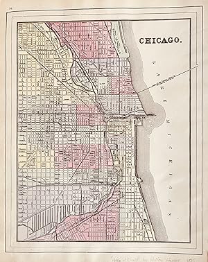
Map of Chicago
Publicado por Philadelphia, 1869
Librería: Nicholas D. Riccio Rare Books, ABAA, Florham Park, NJ, Estados Unidos de America
Miembro de asociación: ABAA ILAB
Calificación del vendedor: 4 de 5 estrellas
EUR 66,55
Envío por EUR 6,89
Se envía dentro de Estados Unidos de AmericaCantidad disponible: 1 disponibles
Ańadir al carritoUnbound, colored engraved map, decorative border, 14"x 11". Slight toning and aging; overall bright and clean. Maps are wrapped with acid free board, or in rigid sleeves. The Mitchell family started to produce atlases in 1846, and continued into the early 1890s. Around 1860, S. Augustus Mitchell Jr. took over, and the atlas would be called Mitchell's New General Atlas. This is a nice map of Chicago from the 1869 installment of this atlas. A very good street map. Ristow 311-313.
-
Map of Chicago
Publicado por Philadelphia, 1870
Librería: Nicholas D. Riccio Rare Books, ABAA, Florham Park, NJ, Estados Unidos de America
Miembro de asociación: ABAA ILAB
Calificación del vendedor: 4 de 5 estrellas
EUR 75,43
Envío por EUR 6,89
Se envía dentro de Estados Unidos de AmericaCantidad disponible: 1 disponibles
Ańadir al carritoUnbound, colored engraved map, decorative border, 14"x 11". Slight toning and aging; overall bright and clean. Maps are wrapped with acid free board, or in rigid sleeves. The Mitchell family started to produce atlases in 1846, and continued into the early 1890s. Around 1860, S. Augustus Mitchell Jr. took over, and the atlas would be called Mitchell's New General Atlas. This is a nice colorful map of Chicago from the 1870 installment of this atlas. Ristow 311-313.
-
1866 Color Steel Engraved Map of ILLINOIS Missouri River CHICAGO City Map
Publicado por Philadelphia : S. Augustus Mitchell, 1866., 1866
Librería: Schilb Antiquarian, Columbia, MO, Estados Unidos de America
Calificación del vendedor: 5 de 5 estrellas

EUR 87,85
Gastos de envío gratis
Se envía dentro de Estados Unidos de AmericaCantidad disponible: 1 disponibles
Ańadir al carritoNo Binding. Condición: Very Good. 1866 Color Steel Engraved Map of ILLINOIS Missouri River CHICAGO City Map Samuel Augustus Mitchell (1790 1868) was an American geographer. Map maker: Samuel Augustus Mitchell Title: "County map of the state of Illinois" Atlas Title: Mitchell's New General Atlas containing maps of the various countries of the world, plans of cities, etc., embraced in fifty-eight quarto maps, forming a series of ninety-two maps and plans, together with valuable statistical tables. Published: Philadelphia : S. Augustus Mitchell, 1866. FREE SHIPPING WORLDWIDE Wear: wear as seen in photos Publisher: Philadelphia : S. Augustus Mitchell, 1866. Size: ~17.5in X 14in (44.5cm x 35.5cm) Photos available upon request.
-
Map of Chicago
Publicado por Bradley, Philadelphia, 1882
Librería: Nicholas D. Riccio Rare Books, ABAA, Florham Park, NJ, Estados Unidos de America
Miembro de asociación: ABAA ILAB
Calificación del vendedor: 4 de 5 estrellas
EUR 88,74
Envío por EUR 6,89
Se envía dentro de Estados Unidos de AmericaCantidad disponible: 1 disponibles
Ańadir al carritoUnbound, colored engraved map, 23"x 15". Slight toning and aging, a little staining or soiling in the margins, a few chips at edge; still rather bright and clear and in very good shape. Maps are wrapped with acid free board, or in rigid sleeves. The Mitchell family started to produce atlases in 1846, and continued into the early 1890s. Around 1860, S. Augustus Mitchell Jr. took over, and the atlas would be called Mitchell's New General Atlas. This is a nice colorful double page map of Chicago from the 1882 installment of this atlas. The map includes Chicago street guide in the lower portion of the map. Ristow 311-313 Phillips 907.
-

Chicago
Publicado por Mitchell, S Augustus, Philadelphia, 1867
Librería: mediumraremaps.com, Franklin, TN, Estados Unidos de America
Calificación del vendedor: 4 de 5 estrellas
Mapa
EUR 97,61
Envío por EUR 5,17
Se envía dentro de Estados Unidos de AmericaCantidad disponible: 1 disponibles
Ańadir al carrito11 1/2 x 13 3/4 inches. Single page lithograph hand-colored at the time of publication. This is Mitchell's presentation prior to the Chicago Fire. It is divided into political units by appropriate coloring. It is a very good example with nice margins. coloring. Very good with nice margins for framing.
-

Chicago
Publicado por Mitchell, S. Augustus, Philadelphia, 1872
Librería: mediumraremaps.com, Franklin, TN, Estados Unidos de America
Calificación del vendedor: 4 de 5 estrellas
Mapa
EUR 119,80
Envío por EUR 5,17
Se envía dentro de Estados Unidos de AmericaCantidad disponible: 1 disponibles
Ańadir al carrito11 x 13 3/4 Inches. Condición: Very good. This map was created in the year after the October, 1871 Chicago Fire. The burnt district has been laid out within the hand coloring scheme. As such, it represents an easy appearance of the delineation within the production of an atlas. The Mitchell firm was prolific in its cartographic output. This period-current presentation was a cartographic scoop with its inclusion in the 1872 atlas.
-

Chicago
Publicado por Mitchell, S. Augustus, Philadelphia, 1880
Librería: mediumraremaps.com, Franklin, TN, Estados Unidos de America
Calificación del vendedor: 4 de 5 estrellas
Mapa
EUR 133,11
Envío por EUR 5,17
Se envía dentro de Estados Unidos de AmericaCantidad disponible: 1 disponibles
Ańadir al carrito21 3/4 x 14 3/8 inches. Double page map of Chicago colored when published. This map is an extension of Mitchell's information set that is not only visual but is textual as well. As such the streets are keyed into the map providing a useful tool for navigating the built landscape. This would make it a good road map on how to get from here to there. Very good having a small marginal chip in the upper side not going into the map.
-

Mitchell's 1865 County Map of Illinois with inset map of Chicago
Ańo de publicación: 1865
Librería: Art Source International Inc., Boulder, CO, Estados Unidos de America
Calificación del vendedor: 5 de 5 estrellas
EUR 66,55
Envío por EUR 13,78
Se envía dentro de Estados Unidos de AmericaCantidad disponible: 2 disponibles
Ańadir al carritoIn 1860 S. Augustus Mitchell Jr. took over his father's map publishing business and in that year he started publishing Mitchell's New General Atlas. Editions of the new general were issued annually until 1887. Mitchell Jr. continued publishing this atlas until 1879. The editions from 1880 to 1887 were published by Wm. M. Bradley. This map published in 1865 is a wonderful example of Mitchell's map-making prowess with beautiful original hand-coloring. This map measures 10.5 inches by 13.5 inches.
-
Chicago.
Publicado por Philadelphia,, 1867
Librería: libreria antiquaria perini Sas di Perini, Verona, VR, Italia
Miembro de asociación: ALAI ILAB
Calificación del vendedor: 5 de 5 estrellas
Arte / Grabado / Póster
EUR 130,00
Envío por EUR 40,00
Se envía de Italia a Estados Unidos de AmericaCantidad disponible: 1 disponibles
Ańadir al carritoIncisione in acciaio, dipinta d'epoca a tutto campo, 284x345. Pianta topografica della citt? di Chicago inquadrata entro bordura decorativa con vitigno intrecciato.Bell'esemplare ben conservato, minimi lievi tracce di sporco superficiale ai margini e numero della carta "68" manoscritto coevo all'ang. sup. destro. Nr.cat: 137.
-
County and Township Map of Illinois Verso has map of St. Louis and also Chicago
Publicado por Hilton & Hughes, New York, 1885
Librería: mediumraremaps.com, Franklin, TN, Estados Unidos de America
Calificación del vendedor: 4 de 5 estrellas
Mapa
EUR 221,85
Envío por EUR 5,17
Se envía dentro de Estados Unidos de AmericaCantidad disponible: 1 disponibles
Ańadir al carrito20 x 14 1/4 inches. Condición: Very good condition. This double page map was executed with printed color. Illinois occupies a double page. On the verso of one is a map of St. Louis. The verso of the other page carries a map of Chicago delicately framed within two external neat lines. This is a very nice cartographic presentation from a rare atlas.
-
Chicago St Louis with a double page mat of Illinois on the verso. County & Township Map of the State of Illinois
Publicado por Hilton & Hughes in Atlas of the World, New York, 1885
Librería: mediumraremaps.com, Franklin, TN, Estados Unidos de America
Calificación del vendedor: 4 de 5 estrellas
Mapa
EUR 221,85
Envío por EUR 5,17
Se envía dentro de Estados Unidos de AmericaCantidad disponible: 1 disponibles
Ańadir al carrito1885 Edition. This map was printed in color and came from an atlas most likely produced by the Bradley Firm that was successor to the Mitchell firm. Further it was apparently published for the firm of Hilton and Hughes whom are listed on the title page as publisher. The map of Chicago and also of St. Louis are pure Mitchell. The map of Illinois is a superb rarecord of the contemporary railroad networks. The map of Illinois is difficult to find in the marketplace and is from a rare late 19th century atlas. Very Good condition with several small tears repaired with archival mending tape Chicago, 10 3/4 x 13 1/2 : St. Louis, 10 3/4 x 14 1/2; Illinois, 14 x 20, with inset of Chicago and Vicinity of 8 1/2 x 6.
-

Chicago
Ańo de publicación: 1887
Librería: Art Source International Inc., Boulder, CO, Estados Unidos de America
Calificación del vendedor: 5 de 5 estrellas
EUR 155,29
Envío por EUR 13,78
Se envía dentro de Estados Unidos de AmericaCantidad disponible: 1 disponibles
Ańadir al carritoThis map was made by S. Augustus Mitchell for "Mitchells New General Atlas" published in 1887. The well maintained maps in this atlas feature Mitchell's characteristic pastel coloring and abundant details of geographical features. The plan of Chicago is illustrated on this map. Details include the names of streets, important buildings, rivers, lakes, parks and railroads. Sections of the city are distinguished by color. These 1887 maps offer a fascinating perspective of areas that have since undergone significant growth and change, in addition to their value as great examples of Mitchell's work. This map measures 11 inches by 13.5 inches.
-

Chicago
Ańo de publicación: 1888
Librería: Art Source International Inc., Boulder, CO, Estados Unidos de America
Calificación del vendedor: 5 de 5 estrellas
EUR 155,29
Envío por EUR 13,78
Se envía dentro de Estados Unidos de AmericaCantidad disponible: 1 disponibles
Ańadir al carritoThis map of Chicago, Illinois was made by S. Augustus Mitchell for "Mitchells New General Atlas" published in 1888, by WM. M. Bradley & Co. The well maintained maps in this atlas feature Mitchell's characteristic pastel coloring and abundant details of geographical features. Details include the names of streets, railroads, transportation routes, lakes, rivers, and various points of interest. These 1888 maps offer a fascinating perspective of areas that have since undergone significant growth and change, in addition to their value as great examples of Mitchell's work. This map measures 11 inches by 13.5 inches.
-

Chicago
Ańo de publicación: 1884
Librería: Art Source International Inc., Boulder, CO, Estados Unidos de America
Calificación del vendedor: 5 de 5 estrellas
EUR 177,48
Envío por EUR 13,78
Se envía dentro de Estados Unidos de AmericaCantidad disponible: 2 disponibles
Ańadir al carritoThis map was made by S. Augustus Mitchell for "Mitchell's New General Atlas" published in 1884, by WM. M. Bradley & Co. The well maintained maps in this atlas feature Mitchell's characteristic pastel coloring and abundant geographical features. Details include the names of streets, rail roads, depots, canals, parks, rivers and creeks. City sections are distinguished by color. These 1884 maps offer a fascinating perspective of areas that have since undergone significant growth and change, in addition to their value as great examples of Mitchell's work. This map measures 11 inches by 13.5 inches.
-

Plan of Chicago
Ańo de publicación: 1875
Librería: Art Source International Inc., Boulder, CO, Estados Unidos de America
Calificación del vendedor: 5 de 5 estrellas
EUR 199,66
Envío por EUR 13,78
Se envía dentro de Estados Unidos de AmericaCantidad disponible: 1 disponibles
Ańadir al carritoThis map was produced by S. Augustus Mitchell in 1875 for his New General Atlas. This map shows Mitchells traditional grape vine border, characteristic pastel coloring and abundant details of geographical features. Counties are distinguished by different colors. Wagon trails and major routes of transport are also shown. These 1875 maps offer a fascinating perspective of areas that have since undergone significant growth and change, in addition to their value as great examples of Mitchell's work. This map measures 11 inches by 14 inches.
-

Chicago
Ańo de publicación: 1872
Librería: Art Source International Inc., Boulder, CO, Estados Unidos de America
Calificación del vendedor: 5 de 5 estrellas
EUR 199,66
Envío por EUR 13,78
Se envía dentro de Estados Unidos de AmericaCantidad disponible: 1 disponibles
Ańadir al carritoExtremely rare and hard to find, this map of Chicago was made by S. Augustus Mitchell in 1872. Pastel coloring differentiates city sections, and city streets, parks, and railroads, depots are illustrated. A distinctive ivy style border completes this map beautifully. This map measures 11 inches by 13.5 inches.
-

Plan of Chicago
Ańo de publicación: 1868
Librería: Art Source International Inc., Boulder, CO, Estados Unidos de America
Calificación del vendedor: 5 de 5 estrellas
EUR 221,85
Envío por EUR 13,78
Se envía dentro de Estados Unidos de AmericaCantidad disponible: 1 disponibles
Ańadir al carritoThis hand colored map was made for "Mitchells New General Atlas" published in 1868 by S. Augustus Mitchell, Jr. The plan of Chicago is illustrated on this map. Sections of the city are distinguished by color. Other details include the names of streets and important buildings, railroads, major roads, and rivers. The pastel coloring in this atlas is very beautiful and more muted than typical. This map measures 11.25 inches by 13.5 inches.


