
Importe total (1 artículo artículos):
Destino del pedido:

c1885 large map england population (2 resultados)
Ir a los resultados principales
Filtros de búsqueda
Tipo de artículo
- Todos los tipos de productos
- Libros (2)
- Revistas y publicaciones (No hay ningún otro resultado que coincida con este filtro.)
- Cómics (No hay ningún otro resultado que coincida con este filtro.)
- Partituras (No hay ningún otro resultado que coincida con este filtro.)
- Arte, grabados y pósters (No hay ningún otro resultado que coincida con este filtro.)
- Fotografías (No hay ningún otro resultado que coincida con este filtro.)
- Mapas (No hay ningún otro resultado que coincida con este filtro.)
- Manuscritos y coleccionismo de papel (No hay ningún otro resultado que coincida con este filtro.)
Condición Más información
- Nuevo (No hay ningún otro resultado que coincida con este filtro.)
- Como nuevo, Excelente o Muy bueno (No hay ningún otro resultado que coincida con este filtro.)
- Bueno o Aceptable (No hay ningún otro resultado que coincida con este filtro.)
- Regular o Pobre (No hay ningún otro resultado que coincida con este filtro.)
- Tal como se indica (2)
Encuadernación
- Todas
- Tapa dura (No hay ningún otro resultado que coincida con este filtro.)
- Tapa blanda (No hay ningún otro resultado que coincida con este filtro.)
Más atributos
- Primera edición (No hay ningún otro resultado que coincida con este filtro.)
- Firmado (No hay ningún otro resultado que coincida con este filtro.)
- Sobrecubierta (No hay ningún otro resultado que coincida con este filtro.)
- Con imágenes (2)
- No impresión bajo demanda (2)
Idioma (1)
Precio
- Cualquier precio
- Menos de EUR 20 (No hay ningún otro resultado que coincida con este filtro.)
- EUR 20 a EUR 45
- Más de EUR 45 (No hay ningún otro resultado que coincida con este filtro.)
Gastos de envío gratis
- Envío gratis a Estados Unidos de America (No hay ningún otro resultado que coincida con este filtro.)
Ubicación del vendedor
Valoración de los vendedores
-

c1885 Large Map ENGLAND WALES DENSITY OF POPULATION Bartholomew (RA3)
Librería: Antique Paper Company, ASHFORD, KENT, Reino Unido
Calificación del vendedor: 2 de 5 estrellas

EUR 23,77
Envío por EUR 6,92
Se envía de Reino Unido a Estados Unidos de AmericaCantidad disponible: 1 disponibles
Ańadir al carritoListing Template 2018 Home About Us View Feedback Contact Us c1885 Large Map ENGLAND WALES DENSITY OF POPULATION Bartholomew (RA3)Click image to enlargeDescriptionc1885An original colour antique map titled:DENSITY OF POPULATIONTaken from The Royal Atlas of England Wales reduced from the Ordnance Survey - A complete series of topographical maps, physical and statistical Charts, Town Plans and Index of 35,000 Names edited by J G Bartholmew published by George Newnes Limited, Southampton Street, Strand, WC. LondonOverall size approx 46.5cm x 36.5cm (18.3 x 14.3in) with central fold as issuedShipping View Our Categories Decorative Prints World Wide Maps Scotland Maps Architecture Design England Maps Royalty About UsWe specialise in selling all items that can be considered to be Antique Paper. * PRINTS * MAPS * HISTORICAL DOCUMENTS * POSTAL HISTORY * BOOKS * POSTERS * STAMPS * POSTCARDS * EPHEMERA And anything else that is considered Antique and made of Paper. ALL OF OUR ITEMS ARE ORIGINAL ANTIQUES - NOT MODERN COPIES. We are also very keen buyers of anything similar and especially after better collections, original archives, whole libraries and better single items and have and#163;250,000 in cash funds at anyone time to buy the right items. Contact UsIf you have any questions then please do not hesitate to contact us through the eBay messaging system. Feedback We will always help you to have a 100% positive happy buying experience. Contact us if you are unhappy about any aspect of your purchase from us. We only want five star feedback from you so buy with confidence.
-
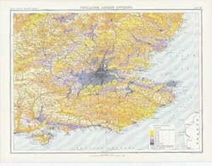
c1885 Large Map ENGLAND - POPULATION LONDON ENVIRONS Bartholomew (RA63)
Librería: Antique Paper Company, ASHFORD, KENT, Reino Unido
Calificación del vendedor: 2 de 5 estrellas
EUR 41,60
Envío por EUR 6,92
Se envía de Reino Unido a Estados Unidos de AmericaCantidad disponible: 1 disponibles
Ańadir al carritoListing Template 2018 Home About Us View Feedback Contact Us c1885 Large Map ENGLAND - POPULATION LONDON ENVIRONS Bartholomew (RA63)Click image to enlargeDescriptionc1885An original colour antique map titled:POPULATION, LONDON ENVIRONSTaken from The Royal Atlas of England Wales reduced from the Ordnance Survey - A complete series of topographical maps, physical and statistical Charts, Town Plans and Index of 35,000 Names edited by J G Bartholmew published by George Newnes Limited, Southampton Street, Strand, WC. LondonOverall size approx 46.5cm x 36.5cm (18.3 x 14.3in) with central fold as issuedShipping View Our Categories Decorative Prints World Wide Maps Scotland Maps Architecture Design England Maps Royalty About UsWe specialise in selling all items that can be considered to be Antique Paper. * PRINTS * MAPS * HISTORICAL DOCUMENTS * POSTAL HISTORY * BOOKS * POSTERS * STAMPS * POSTCARDS * EPHEMERA And anything else that is considered Antique and made of Paper. ALL OF OUR ITEMS ARE ORIGINAL ANTIQUES - NOT MODERN COPIES. We are also very keen buyers of anything similar and especially after better collections, original archives, whole libraries and better single items and have and#163;250,000 in cash funds at anyone time to buy the right items. Contact UsIf you have any questions then please do not hesitate to contact us through the eBay messaging system. Feedback We will always help you to have a 100% positive happy buying experience. Contact us if you are unhappy about any aspect of your purchase from us. We only want five star feedback from you so buy with confidence.