Importe total (1 artículo artículos):
Destino del pedido:

antique map vermont (14 resultados)
Ir a los resultados principales
Filtros de búsqueda
Tipo de artículo
- Todos los tipos de productos
- Libros (3)
- Revistas y publicaciones (No hay ningún otro resultado que coincida con este filtro.)
- Cómics (No hay ningún otro resultado que coincida con este filtro.)
- Partituras (No hay ningún otro resultado que coincida con este filtro.)
- Arte, grabados y pósters (1)
- Fotografías (No hay ningún otro resultado que coincida con este filtro.)
- Mapas (10)
- Manuscritos y coleccionismo de papel (No hay ningún otro resultado que coincida con este filtro.)
Condición Más información
- Nuevo (No hay ningún otro resultado que coincida con este filtro.)
- Como nuevo, Excelente o Muy bueno (No hay ningún otro resultado que coincida con este filtro.)
- Bueno o Aceptable (3)
- Regular o Pobre (No hay ningún otro resultado que coincida con este filtro.)
- Tal como se indica (11)
Encuadernación
- Todas
- Tapa dura (No hay ningún otro resultado que coincida con este filtro.)
- Tapa blanda (No hay ningún otro resultado que coincida con este filtro.)
Más atributos
- Primera edición (No hay ningún otro resultado que coincida con este filtro.)
- Firmado (No hay ningún otro resultado que coincida con este filtro.)
- Sobrecubierta (No hay ningún otro resultado que coincida con este filtro.)
- Con imágenes (12)
- No impresión bajo demanda (14)
Idioma (2)
Gastos de envío gratis
- Envío gratis a Estados Unidos de America (No hay ningún otro resultado que coincida con este filtro.)
Ubicación del vendedor
Valoración de los vendedores
-
VERMONT,Antique Coloured Map,1896 Historical Topographical Map
Publicado por Universal Geography
Librería: Artisans-lane Maps & Prints, Sidney, BC, Canada
Calificación del vendedor: 4 de 5 estrellas

Arte / Grabado / Póster
EUR 19,33
Envío por EUR 16,36
Se envía de Canada a Estados Unidos de AmericaCantidad disponible: 1 disponibles
Ańadir al carritono binding. Condición: very good. PUBLISHED DATE 1896 PAGE SIZE 7 1/2 x 11 inches PUBLISHER APPLETON CONDITION FULL PAGE MAP. Blank on back. Suitable ageing. As scanned. The image is clean, clear and sharp with beautiful detail.NOTE THE FOLLOWING BEFORE YOU PURCHASE: THIS IS IS A GENUINE ANTIQUE PRINT. It is NOT a modern reproduction,ie. a laser scan,photography etc.It is the original from the antique atlas or book publication.This map/print was published on the date mentioned, or circa of the date mentioned at the top of the page.The print/map I have for sale, like many antique maps and prints that you see online, originate from an antique book or atlas publication. The publication may not always be known. If you have any questions, emails are welcome.
-

North America - New York, vermont, Maine, New Hampshire, Massachusetts, Connecticut, Rhode Island and New Jersey - an Antique Map
Idioma: Inglés
Librería: K Books Ltd ABA ILAB, York, YORKS, Reino Unido
Miembro de asociación: ABA ILAB PBFA
Calificación del vendedor: 5 de 5 estrellas

EUR 35,41
Envío por EUR 22,35
Se envía de Reino Unido a Estados Unidos de AmericaCantidad disponible: 1 disponibles
Ańadir al carritoNo Binding. Condición: Very Good. Engraved By Walker Ilustrador. A fine antique map in very good condition - printed in circa 1844. Mounted (matted) and ready to frame. Engraved Size 14 x 10 Ins 35 x 25 cms. Mount size approx 17 x 13 ins, 43 x33 cms. Coloured in outline, hand colouring contemporary. A fine engraved map of North America - New York, vermont, Maine, New Hampshire, Massachusetts, Connecticut, Rhode Island and New Jersey.
-
North America, Lower Canada and New Brunswick, with Part of New York , vermont and Maine - an Antique Map
Idioma: Inglés
Librería: K Books Ltd ABA ILAB, York, YORKS, Reino Unido
Miembro de asociación: ABA ILAB PBFA
Calificación del vendedor: 5 de 5 estrellas
EUR 41,31
Envío por EUR 22,35
Se envía de Reino Unido a Estados Unidos de AmericaCantidad disponible: 1 disponibles
Ańadir al carritoNo Binding. Condición: Very Good. Engraved By Walker Ilustrador. A fine antique map in very good condition - printed in circa 1844. Mounted (matted) and ready to frame. Engraved size approx 16 x 13 Ins, 41 x 33 Cms. Mounted size approx 19 x 16 in, 49 x 41cm. Coloured in outline, hand colouring contemporary. A fine engraved map of North America, Lower Canada and New Brunswick, with Part of New York , vermont and Maine.
-

Vermont Gray, Frank Vermont Antique Map, Lithograph 378 x 303mm O.W. Gray & Son, Philadelphia 1884
Publicado por O.W. Gray & Son, Philadelphia, 1884
Librería: Antiquariat Reinhold Berg eK Inh. R.Berg, Regensburg, Alemania
Miembro de asociación: ILAB VDA
Calificación del vendedor: 5 de 5 estrellas
Mapa
EUR 45,00
Envío por EUR 24,00
Se envía de Alemania a Estados Unidos de AmericaCantidad disponible: 1 disponibles
Ańadir al carritoOther. Lithograph, hand-colored in outline by Gray, Frank, published 1884 by O.W. Gray & Son, Philadelphia. Image size: 378 by 303mm (15 by 12 inches). From Gray's Atlas one of the most important American commercial atlases of the post-Civil War era. Frank A. Gray was an American cartographer working in the 1870s and 1880s for the Philadelphia-based firm O.W. Gray & Son, one of the leading commercial map publishers of the post-Civil War United States. Founded by Ormando Willis Gray, a civil and topographical engineer, the firm produced Gray's Atlas of the United States and its many regional successors. Gray's National Atlas was among the most successful commercial atlas ventures of the 1870s and one of the last American atlases to employ hand-coloring. The state maps of the 1880s are noted for their excellent topographical detail, clear depiction of the expanding railroad network, and accurate county boundaries invaluable primary sources for historians and sought-after collector pieces today.This antique map shows the state of Vermont in the United States. The map is divided up into its counties and provides detailed information on small place names, rivers, lakes, streets etc. On the right is a small explanation for this map. In very good condition. In very good condition. 378 by 303mm (15 by 12 inches). 378 by 303mm (15 by 12 inches).
-

North America Sheet II the Dominion of Canada Parts of Quebe and New Brunswick and the States of New York, Vermont and Maine. S. D. U. K. North America Sheet II the Dominion of Canada Parts of. Antique Map, Steel Engraving 340 x 395mm Baldwin & Cradock, London 1875
Publicado por Baldwin & Cradock, London, 1875
Librería: Antiquariat Reinhold Berg eK Inh. R.Berg, Regensburg, Alemania
Miembro de asociación: ILAB VDA
Calificación del vendedor: 5 de 5 estrellas
Mapa
EUR 60,00
Envío por EUR 24,00
Se envía de Alemania a Estados Unidos de AmericaCantidad disponible: 1 disponibles
Ańadir al carritoOther. Steel Engraving, hand-colored in outline by S. D. U. K, published 1875 by Baldwin & Cradock, London. Image size: 340 by 395mm (13 by 15 inches). From the celebrated SDUK series widely regarded as among the finest steel-engraved maps of the 19th century. The Society for the Diffusion of Useful Knowledge (SDUK) was a Whig organization founded in London in 1826 with the admirable goal of making information accessible to the working and middle classes. Its map committee began publishing in 1829, producing a celebrated series of finely engraved steel maps initially under the Baldwin & Cradock imprint, later reissued by Chapman & Hall (from 1844) and Charles Knight. The SDUK maps are renowned for their exceptional precision, elegant typography, and fine steel engraving widely considered among the finest examples of British cartography from the first half of the 19th century. Their North American sheets were produced at a transformative moment in the continent's history, making them invaluable historical documents as well as beautiful collector objects.Decorative antique map of Canada, in the centre of the map the St. Lawrence river, further the map with many detailed place names, rivers and lakes. The territorial boundaries of the individual regions are decorative and colorful shown in this period outline and wash handcolor. This 1875 edition from the famous SDUK series differs in its unusual decorative colors, compared to the 1840 edition, which always was either uncolored or in outline color published. In excellent condition. In excellent condition. 340 by 395mm (13 by 15 inches).
-

Johnson's New Hampshire and Vermont by Johnson & Browning. Johnson & Browning Johnson's New Hampshire and Vermont by Johnson & Browni. Antique Map, Lithograph 608 x 425mm Johnson & Ward, New York 1868
Publicado por Johnson & Ward, New York, 1868
Librería: Antiquariat Reinhold Berg eK Inh. R.Berg, Regensburg, Alemania
Miembro de asociación: ILAB VDA
Calificación del vendedor: 5 de 5 estrellas
Mapa
EUR 65,00
Envío por EUR 24,00
Se envía de Alemania a Estados Unidos de AmericaCantidad disponible: 1 disponibles
Ańadir al carritoOther. Lithograph, original color in outline by Johnson & Browning, published 1868 by Johnson & Ward, New York. Image size: 608 by 425mm (24 by 16 inches). From Johnson's New Illustrated Family Atlas the leading American atlas of the Civil War era. A.J. Johnson (Alvin Jewett Johnson, 18271884) launched his celebrated atlas series after acquiring Colton's plates in 1860, initially publishing as Johnson & Browning before reorganizing as Johnson & Ward in 1863. Johnson's New Illustrated Family Atlas became the dominant American commercial atlas of the Civil War era, offering detailed steel-engraved state and regional maps with vivid hand-applied outline coloring. These atlases were sold by subscription and reached a vast American audience, making them among the most widely distributed and today most collectible American maps of the 19th century.This antique map shows the states New Hampshire and Vermont. The map is very detailed engraved with many place names, rivers, streets etc. A decorative large scale map of New Hampshire & Vermont, decorated with an ornated border around the map. In excellent condition. In excellent condition. 608 by 425mm (24 by 16 inches).
-

North America Sheet VI New York, Vermont, Maine, New Hampshire, Massachusetts, Connecticut, Rhode Island, and New Jersey. SDUK (Society for the diffusion of useful knowledge) North America Sheet VI New York, Vermont, Maine, New Ha. Antique Map, Steel Engraving 352 x 312m.
Publicado por Baldwin & Cradock, London, 1832
Librería: Antiquariat Reinhold Berg eK Inh. R.Berg, Regensburg, Alemania
Miembro de asociación: ILAB VDA
Calificación del vendedor: 5 de 5 estrellas
Mapa
EUR 95,00
Envío por EUR 24,00
Se envía de Alemania a Estados Unidos de AmericaCantidad disponible: 1 disponibles
Ańadir al carritoOther. Steel Engraving, hand-colored in outline by SDUK (Society for the diffusion of useful knowledge), published 1832 by Baldwin & Cradock, London. Image size: 352 by 312mm (13 by 12 inches). From the celebrated SDUK series widely regarded as among the finest steel-engraved maps of the 19th century. The Society for the Diffusion of Useful Knowledge (SDUK) was a Whig organization founded in London in 1826 with the admirable goal of making information accessible to the working and middle classes. Its map committee began publishing in 1829, producing a celebrated series of finely engraved steel maps initially under the Baldwin & Cradock imprint, later reissued by Chapman & Hall (from 1844) and Charles Knight. The SDUK maps are renowned for their exceptional precision, elegant typography, and fine steel engraving widely considered among the finest examples of British cartography from the first half of the 19th century. Their North American sheets were produced at a transformative moment in the continent's history, making them invaluable historical documents as well as beautiful collector objects.This North America map shows the east coast from New Jersey to Maine. The individual states are painted beautifully in outline color. The title is engraved in the lower right corner. In excellent condition. 352 by 312mm (13 by 12 inches). In excellent condition. 352 by 312mm (13 by 12 inches). 352 by 312mm (13 by 12 inches).
-

Neueste Karte von New Hampshire und Vermont 1846. Meyer, Joseph Neueste Karte von New Hampshire und Vermont 1846 Antique Map, Steel Engraving 372 x 298mm Bibliograph. Institut, Hildburghausen 1846
Publicado por Bibliograph. Institut, Hildburghausen, 1846
Librería: Antiquariat Reinhold Berg eK Inh. R.Berg, Regensburg, Alemania
Miembro de asociación: ILAB VDA
Calificación del vendedor: 5 de 5 estrellas
Mapa
EUR 110,00
Envío por EUR 24,00
Se envía de Alemania a Estados Unidos de AmericaCantidad disponible: 1 disponibles
Ańadir al carritoOther. Steel Engraving, hand-colored in outline by Meyer, Joseph, published 1846 by Bibliograph. Institut, Hildburghausen. Image size: 372 by 298mm (14 by 11 inches). From Meyer's acclaimed steel-engraved atlas, one of the finest German cartographic productions of the 19th century. Joseph Meyer (17961856) was one of the most prolific and influential German publishers of the 19th century. Born in Gotha, he founded the Bibliographisches Institut, which he moved to Hildburghausen in 1828, and built it into a leading European publishing house. Meyer produced numerous finely engraved atlases, including the celebrated Meyer's Gro?er Hand-Atlas (18431860), engraved with exceptional precision on steel plates by his talented team of cartographers including Carl Radefeld. His maps of North American states from the 1840s and 1850s are based on the best available American sources of the period, including Tanner's surveys, and offer a detailed German perspective on the rapidly expanding United States. Meyer's steel engravings, often hand-colored in outline, are treasured by collectors for their technical perfection and historical accuracy.Detailed map of the state of the state of Vermont and New Hampshire. Inside the map are many place names, rivers, lakes, streets, etc. In the upper right corner we find a table with an explanation for this map showing the duchies and main cities of New Hampshire & Vermont. At the bottom are mileage scales. In very good condition. Slightly stained throughout, more recognizable in the margins of the map. This edition is published with a centre fold. In very good condition. Slightly stained throughout, more recognizable in the margins of the map. This edition is published with a centre fold. 372 by 298mm (14 by 11 inches). 372 by 298mm (14 by 11 inches).
-

Neueste Karte von New Hampshire und Vermont 1851. Meyer, Joseph Neueste Karte von New Hampshire und Vermont 1851 Antique Map, Steel Engraving 373 x 298mm Bibliograph. Institut, Hildburghausen 1851
Publicado por Bibliograph. Institut, Hildburghausen, 1851
Librería: Antiquariat Reinhold Berg eK Inh. R.Berg, Regensburg, Alemania
Miembro de asociación: ILAB VDA
Calificación del vendedor: 5 de 5 estrellas
Mapa
EUR 120,00
Envío por EUR 24,00
Se envía de Alemania a Estados Unidos de AmericaCantidad disponible: 1 disponibles
Ańadir al carritoOther. Steel Engraving, hand-colored in outline by Meyer, Joseph, published 1851 by Bibliograph. Institut, Hildburghausen. Image size: 373 by 298mm (14 by 11 inches). From Meyer's acclaimed steel-engraved atlas, one of the finest German cartographic productions of the 19th century. Joseph Meyer (17961856) was one of the most prolific and influential German publishers of the 19th century. Born in Gotha, he founded the Bibliographisches Institut, which he moved to Hildburghausen in 1828, and built it into a leading European publishing house. Meyer produced numerous finely engraved atlases, including the celebrated Meyer's Gro?er Hand-Atlas (18431860), engraved with exceptional precision on steel plates by his talented team of cartographers including Carl Radefeld. His maps of North American states from the 1840s and 1850s are based on the best available American sources of the period, including Tanner's surveys, and offer a detailed German perspective on the rapidly expanding United States. Meyer's steel engravings, often hand-colored in outline, are treasured by collectors for their technical perfection and historical accuracy.Detailed map of the state of the state of New Hampshire & Vermont. Inside the map are many place names, rivers, lakes, streets, etc. In the upper right corner we find a table with an explanation for this map showing the duchies and main cities of Vermont and New Hampshire. At the bottom are mileage scales. In excellent condition. In excellent condition. 373 by 298mm (14 by 11 inches). 373 by 298mm (14 by 11 inches).
-

Vermont. Carte Géographique, Statistique et Historique Du Vermont. Buchon, Jean Alexandre Vermont. Carte Géographique, Statistique et Historique. Antique Map, Copper Engraving 438 x 610mm J. Carez, Paris 1825
Publicado por J. Carez, Paris, 1825
Librería: Antiquariat Reinhold Berg eK Inh. R.Berg, Regensburg, Alemania
Miembro de asociación: ILAB VDA
Calificación del vendedor: 5 de 5 estrellas
Mapa
EUR 240,00
Envío por EUR 24,00
Se envía de Alemania a Estados Unidos de AmericaCantidad disponible: 1 disponibles
Ańadir al carritoOther. Copper Engraving, hand-colored in outline by Buchon, Jean Alexandre, published 1825 by J. Carez, Paris. Image size: 438 by 610mm (17 by 24 inches). A detailed map from Buchon's 1825 Atlas géographique, the French edition of Carey & Lea's celebrated American atlas. Jean Alexandre Buchon (17911846) was a French historian and geographer who produced the influential Atlas géographique, statistique, historique et chronologique des deux Amériques et des îles adjacentes (1825), published in Paris by J. Carez. This atlas was the French edition of the celebrated Carey & Lea atlas of the United States. Each map was surrounded by letterpress text describing the economic, political, geographical, and historical statistics of the depicted region in French, making it an extraordinary reference work for European readers at the dawn of the Americas' independence era. The maps were engraved in Paris to the highest standards of the day and remain important primary documents for the study of early 19th-century American geography as understood by European scholars.Fine engraved map of Vermont, showing various rivers, trails, streets, villages and small place names. Vermont is divided up into its counties in original wash hand color. The map is surrounded by descriptive text on Vermont, providing information on the climate, the rivers, cities and its history. A nice and decorative map of Vermont. In excellent condition. In excellent condition. 438 by 610mm (17 by 24 inches). 438 by 610mm (17 by 24 inches).
-
(Vermont - New Hampshire - Maine - New Brunswick) Smith, J. Calvin (Vermont - New Hampshire - Maine - New Brunswick) Antique Map, Lithograph 370 x 475mm Th. Fischer, Cassel 1845
Publicado por Th. Fischer, Cassel, 1845
Librería: Antiquariat Reinhold Berg eK Inh. R.Berg, Regensburg, Alemania
Miembro de asociación: ILAB VDA
Calificación del vendedor: 5 de 5 estrellas
Mapa
EUR 295,00
Envío por EUR 24,00
Se envía de Alemania a Estados Unidos de AmericaCantidad disponible: 1 disponibles
Ańadir al carritoOther. Lithograph, hand-colored in outline by Smith, J. Calvin, published 1845 by Th. Fischer, Cassel. Image size: 370 by 475mm (14 by 18 inches). From Smith's multi-sheet Special-Karte one of the most detailed and accurate mid-19th-century maps of the United States. John Calvin (J. Calvin) Smith (c.18091890) was an American surveyor, geographer, and engraver active in New York City from the 1840s. Working with partners including George Sherman (under the Sherman & Smith imprint, 18401853) and later in association with J.H. Colton, Smith produced some of the most accurate and widely used general-purpose maps of the United States of his era. His maps appeared in government publications, military surveys, and commercial atlases, and his multi-sheet Special-Karte der Vereinigten Staaten (published in a German-language edition) brought American cartographic standards to European audiences. Despite his prolific output and importance to American cartographic history, much of Smith's personal biography remains obscure.This antique map shows prominent in its centre the state of Maine with its neighboring states Vermont, New Hampshire and New Brunswick. The map extends from Salisbury in the south towards New Brunswick and the neighboring Nova Scotia. Inside the map are many place names, rivers, lakes, mountains, railroads, etc. Many counties are named and finely hand colored in wash. A detailed map of this part of the Northeastern United States by the famous 19th century mapmaker and cartographer Calvin Smith. In very good condition. A few small marginal mended tears at the blank margins, verso old backed (not affecting the image of the map). In very good condition. A few small marginal mended tears at the blank margins, verso old backed (not affecting the image of the map). 370 by 475mm (14 by 18 inches). 370 by 475mm (14 by 18 inches).
-
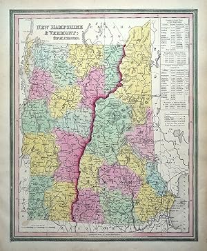
Antique Map NEW HAMPSHIRE, VERMONT, USA, State map H.S.Tanner Original 1844
Librería: Lindisfarne Prints, Shrewsbury, SHROP, Reino Unido
Calificación del vendedor: 5 de 5 estrellas
Mapa
EUR 64,92
Envío por EUR 12,61
Se envía de Reino Unido a Estados Unidos de AmericaCantidad disponible: 1 disponibles
Ańadir al carritoAntique Map NEW HAMPSHIRE& VERMONTby Henry Schenck TannerPublished in Tanner's "New Universal Atlas", Philadelphia 1844.An original 19th century antique state map of New Hampshire and Vermont, USA. Dated in the plate (1840).An interesting map with attractive original hand colour and distinctive green braid effect border. An inset table displays the populations of counties and county towns.Fine, clean condition, free of repairs or restoration, not folded, blank verso.Approx. 14.5" x 11.5" (370mm x 300mm) map area only, with margins beyond. A GENUINE ORIGINAL ANTIQUE MAP GUARANTEED OVER 170 YEARS OLD FROM LINDISFARNE PRINTSNFP1220.
-
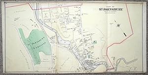
Antique Map USA St.JOHNSBURY, VERMONT,Caledonia County Original Lithograph 1875
Librería: Lindisfarne Prints, Shrewsbury, SHROP, Reino Unido
Calificación del vendedor: 5 de 5 estrellas
Mapa
EUR 76,72
Envío por EUR 12,61
Se envía de Reino Unido a Estados Unidos de AmericaCantidad disponible: 1 disponibles
Ańadir al carritoAntique Map Street PlanPart ofSt. JOHNSBURY Town of St.JohnsburyPublished 1875 by F.W.Beers & Co in "Caledonia County 1875"A fascinating 19th century large format map of Saint Johnsbury, Vermont, USA with original hand colouring.The large scale of 200ft to the inch affords extraordinary detail including not only individual buildings but the names of the occupiers of each house.There are also a number of factories and workshops and one of those named is the Paddock Iron Works, which has assisted us in verifying the age of the map.Paddock Iron Works ceased trading under that name in 1878 and became Hooker & Sons. In 1926 it became the Reed Supply Company and still trades under that name to the present day.Other business premises include a Box Factory, McCleod's Grist Mill, an Ice House and many more.An invaluable record of 19th century St.Johnsbury. This is an original example of the map and not a modern reproduction.Some minor edge tears have been repaired verso with archival tape, otherwise fine condition. Fold lines as issued.Approx. 31" x 15.5" (790mm x 400mm) overallA GENUINE ANTIQUE MAP GUARANTEED OVER 140 YEARS OLD FROM LINDISFARNE PRINTSD1020.
-

Antique Map of Vermont
Librería: Bartele Gallery - The Netherlands, Langweer, FRL, Holanda
Miembro de asociación: ILAB NVVA
Calificación del vendedor: 5 de 5 estrellas
EUR 290,00
Envío por EUR 17,00
Se envía de Holanda a Estados Unidos de AmericaCantidad disponible: 1 disponibles
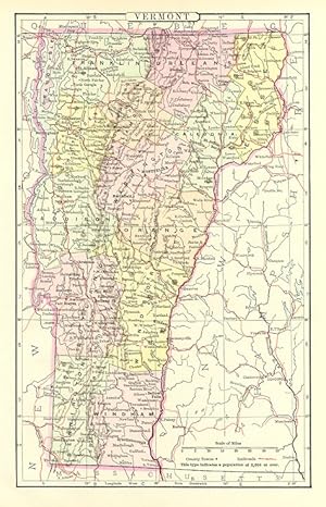
Ańadir al carritoAntique map titled 'Vermont'. Original antique map of Vermont, United States. This print originates from 'Encyclopaedia Britannica', Ninth Edition. Published 1888. The Encyclopćdia Britannica has been published continuously since 1768, appearing in fifteen official editions. Several editions have been amended with multi-volume "supplements" (3rd, 5th/6th), consisted of previous editions with added supplements (10th, and 12th/13th) or gone drastic re-organizations (15th). In recent years, digital versions of the Britannica have been developed, both online and on optical media. Since the early 1930s, the Britannica has developed several "spin-off" products to leverage its reputation as a reliable reference work and educational tool. The Encyclopedia as known up to 2012 was incurring unsustainable losses and the print editions were ended, but it continues on the Internet.