
Antique map thames valley reading (1 resultados)
 Más imágenes
- Primera edición
- Mapa
Librería: Lindisfarne Prints, Shrewsbury, SHROP, Reino UnidoLindisfarne Prints
Contactar con el vendedorVendedor de 5 estrellasCondición: Usado
EUR 24,24
Envío por EUR 21,77Se envía de Reino Unido a Estados Unidos de AmericaCantidad disponible: 1 disponibles
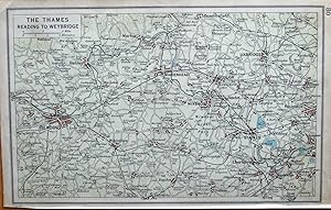
Añadir al carritoAn Original Vintage Map of the Thames ValleyTHE THAMES READING TO WEYBRIDGECovering areas includingPangbourne, Caversham, Henley, Marlow, Wokingham, Ascot, Beaconsfield, Slough, Chertsey, Pinner, Northolt & Esher.Published by The Geographical Institute, Edinburgh 1925 by John Bartholomew & Sonfor" Bartholomew's Handy Reference A…tlas of London and Suburbs"5th EditionA detailed, little lithographed map of the Thames Valley.Apart from the main towns the map also identifies many villages and hamlets, railways and points of interest such as Sandhurst Military College, Windsor Great Park & Northolt Aerodrome.There is an unrelated map verso.Fine, virtually unmarked condition . Measuring approx. 9"x 5" ( 230mm x 130mm) overall. A collectible item eminently suitable for framing. T 41 9 20.John George Bartholomew (22 March 1860 ? 14 April 1920) was a British Cartographer and Geographer. As a holder of a Royal Warrant, he used the title "Cartographer to the King"; for this reason he was sometimes known by the epithet "the Prince of Cartography".It was he who introduced the use of coloured contour layer maps; he also anticipated the needs of late nineteenth and early 20-century travellers by publishing street maps of major cities, cycling maps, railway timetable maps, and road maps for automobiles.The first edition of this atlas was published in 1908 .
