
Importe total (1 artículo artículos):
Destino del pedido:

antique map new jersey (18 resultados)
Ir a los resultados principales
Filtros de búsqueda
Tipo de artículo
- Todos los tipos de productos
- Libros (9)
- Revistas y publicaciones (No hay ningún otro resultado que coincida con este filtro.)
- Cómics (No hay ningún otro resultado que coincida con este filtro.)
- Partituras (No hay ningún otro resultado que coincida con este filtro.)
- Arte, grabados y pósters (5)
- Fotografías (No hay ningún otro resultado que coincida con este filtro.)
- Mapas (4)
- Manuscritos y coleccionismo de papel (No hay ningún otro resultado que coincida con este filtro.)
Condición Más información
- Nuevo (No hay ningún otro resultado que coincida con este filtro.)
- Como nuevo, Excelente o Muy bueno (No hay ningún otro resultado que coincida con este filtro.)
- Bueno o Aceptable (6)
- Regular o Pobre (No hay ningún otro resultado que coincida con este filtro.)
- Tal como se indica (12)
Encuadernación
- Todas
- Tapa dura (No hay ningún otro resultado que coincida con este filtro.)
- Tapa blanda (No hay ningún otro resultado que coincida con este filtro.)
Más atributos
- Primera edición (No hay ningún otro resultado que coincida con este filtro.)
- Firmado (No hay ningún otro resultado que coincida con este filtro.)
- Sobrecubierta (No hay ningún otro resultado que coincida con este filtro.)
- Con imágenes (16)
- No impresión bajo demanda (18)
Idioma (3)
Gastos de envío gratis
- Envío gratis a Estados Unidos de America (No hay ningún otro resultado que coincida con este filtro.)
Ubicación del vendedor
Valoración de los vendedores
-
BARNEGAT BAY,LONG ISLAND,NEW JERSEY,1893 1800s Antique Map
Publicado por Reclus
Librería: Artisans-lane Maps & Prints, Sidney, BC, Canada
Calificación del vendedor: 5 de 5 estrellas

Arte / Grabado / Póster
EUR 9,61
Envío por EUR 16,31
Se envía de Canada a Estados Unidos de AmericaCantidad disponible: 1 disponibles
Ańadir al carritono binding. Condición: very good. BARNEGAT BAY,LONG ISLAND,NEW JERSEY ,1893,Antique Historical Relief Map BARNEGAT BAY - LONG ISLAND - NEW JERSEY 1893 Historical Map - Wood Engraving Approx Image Size: 4 1/2 x 3 3/4 ins Overall Page Size: 10 1/2 x 7 ins PRINT SHOWS: Barnegat Bay is a small brackish arm of the Atlantic Ocean, approximately 30 miles (50 km) long, along the coast of Ocean County, New Jersey in the United States. It is essentially a long estuary formed by Barnegat Peninsula, a long barrier peninsula, as well as by the north end of Long Beach Island. The bay is fed by several small rivers, including the Toms River and Metedeconk River, which empty into the bay through small estuaries along its inner shore. The communities of Toms River, Silverton, and Forked River sit along the river estuaries on the bay.The bay is entered from the ocean through the Barnegat Inlet, along which sits the now defunct Barnegat Lighthouse. The bay is part of the Atlantic Intracoastal Waterway, entered on its north end by the Point Pleasant Canal and connecting on the south end with Little Egg Harbor via the small Manahawkin Bay. In a broader sense, the bay is sometimes considered to stretch to the south end of Long Beach Island and to include Little Egg Harbor.The area surrounding the Barnegat Bay and Barnegat Inlet were described by Henry Hudson, in 1609, as ".a great lake of water, as we could judge it to be . The mouth of the lake hath many shoals, and the sea breaketh on them as it is cast out of the mouth of it." The bay was originally named in 1614 "Barendegat," or "Inlet of the Breakers," by Dutch settlers, referring to the waterway's turbulent channel. During the American Revolutionary War, the bay was used as refuge by American pirates.Excellent Condition. Map Image is clean, clear, sharp with beautiful detail. Intext Bookplate Map with Text on the back. Printed on cream color coated paper. I prefer paypal or money orders. Delivery time for items can be anywhere from 10-28 days depending on your location. Items will be shipped within 2 business days of payment received. Checks will need time to clear before items are sent.
-
SANDY HOOK,NEW JERSEY,1893 1800s Antique Map
Publicado por Reclus
Librería: Artisans-lane Maps & Prints, Sidney, BC, Canada
Calificación del vendedor: 5 de 5 estrellas
Arte / Grabado / Póster
EUR 9,61
Envío por EUR 16,31
Se envía de Canada a Estados Unidos de AmericaCantidad disponible: 1 disponibles
Ańadir al carritono binding. Condición: very good. SANDY HOOK,NEW JERSEY,1893,Antique Historical Relief Map SANDY HOOK,NEW JERSEY 1893 Historical Map - Wood Engraving Approx Image Size: 5 x 3 ins Overall Page Size: 10 1/2 x 7 ins PRINT SHOWS: Sandy Hook, low, sandy peninsula, NE N.J., projecting 5 mi (8 km) N toward New York and separating Sandy Hook Bay from the Atlantic Ocean. At the northern end is a Coast Guard station and the former Fort Hancock, which was built to protect New York harbor and was once used as a proving ground for heavy artillery. The Sandy Hook Lighthouse (85 ft/25.9 km high; built 1763) is the oldest in service in the United States. Henry Hudson's team explored this region in 1609. The British held the peninsula during the American Revolution.Excellent Condition. Map Image is clean, clear, sharp with beautiful detail. Intext Bookplate Map with Text on the back. Printed on cream color coated paper. I prefer paypal or money orders. Delivery time for items can be anywhere from 10-28 days depending on your location. Items will be shipped within 2 business days of payment received. Checks will need time to clear before items are sent.
-
CAPE MAY, NEW JERSEY,1893 1800s Antique Map
Publicado por Reclus
Librería: Artisans-lane Maps & Prints, Sidney, BC, Canada
Calificación del vendedor: 5 de 5 estrellas
Arte / Grabado / Póster
EUR 9,61
Envío por EUR 16,31
Se envía de Canada a Estados Unidos de AmericaCantidad disponible: 1 disponibles
Ańadir al carritono binding. Condición: very good. CAPE MAY, NEW JERSEY ,1893,Antique Historical Relief Map CAPE MAY, NEW JERSEY 1893 Historical Map - Wood Engraving Approx Image Size: 4 1/2 x 4 1/2 ins Overall Page Size: 10 1/2 x 7 ins PRINT SHOWS: Cape May is a cape and peninsula which is the southernmost point of the state of New Jersey, United States. It runs southwards from the New Jersey mainland, separating Delaware Bay from the Atlantic Ocean. The cape is named for Cornelius Jacobsen Mey, a Dutch explorer who was working for the Dutch East India Company.Excellent Condition. Map Image is clean, clear, sharp with beautiful detail. Intext Bookplate Map with Text on the back. Printed on cream color coated paper. I prefer paypal or money orders. Delivery time for items can be anywhere from 10-28 days depending on your location. Items will be shipped within 2 business days of payment received. Checks will need time to clear before items are sent.
-
NEW JERSEY,Antique Coloured Map,1896 Historical Topographical Map
Publicado por Universal Geography
Librería: Artisans-lane Maps & Prints, Sidney, BC, Canada
Calificación del vendedor: 5 de 5 estrellas
Arte / Grabado / Póster
EUR 19,23
Envío por EUR 16,31
Se envía de Canada a Estados Unidos de AmericaCantidad disponible: 1 disponibles
Ańadir al carritono binding. Condición: very good. PUBLISHED DATE 1896 PAGE SIZE 14 x 11 inches PUBLISHER APPLETON CONDITION FULL PAGE MAP. Blank on back. Suitable ageing. As scanned. The image is clean, clear and sharp with beautiful detail.NOTE THE FOLLOWING BEFORE YOU PURCHASE: THIS IS IS A GENUINE ANTIQUE PRINT. It is NOT a modern reproduction,ie. a laser scan,photography etc.It is the original from the antique atlas or book publication.This map/print was published on the date mentioned, or circa of the date mentioned at the top of the page.The print/map I have for sale, like many antique maps and prints that you see online, originate from an antique book or atlas publication. The publication may not always be known. If you have any questions, emails are welcome.
-

North America - Pennsylvania, New Jersey, Maryland, Delaware, Columbia and Part of Virginia - an Antique Map
Idioma: Inglés
Librería: K Books Ltd ABA ILAB, York, YORKS, Reino Unido
Miembro de asociación: ABA ILAB PBFA
Calificación del vendedor: 5 de 5 estrellas
EUR 35,68
Envío por EUR 22,52
Se envía de Reino Unido a Estados Unidos de AmericaCantidad disponible: 1 disponibles
Ańadir al carritoNo Binding. Condición: Very Good. Engraved By Walker Ilustrador. A fine antique map in very good condition - printed in circa 1844. Mounted (matted) and ready to frame. Engraved size approx 16 x 13 Ins, 41 x 33 Cms. Mounted size approx 19 x 16 in, 49 x 41cm. Coloured in outline, hand colouring contemporary. A fine engraved map of North America - Pennsylvania, New Jersey, Maryland, Delaware, Columbia and Part of Virginia.
-
North America - New York, vermont, Maine, New Hampshire, Massachusetts, Connecticut, Rhode Island and New Jersey - an Antique Map
Idioma: Inglés
Librería: K Books Ltd ABA ILAB, York, YORKS, Reino Unido
Miembro de asociación: ABA ILAB PBFA
Calificación del vendedor: 5 de 5 estrellas
EUR 35,68
Envío por EUR 22,52
Se envía de Reino Unido a Estados Unidos de AmericaCantidad disponible: 1 disponibles
Ańadir al carritoNo Binding. Condición: Very Good. Engraved By Walker Ilustrador. A fine antique map in very good condition - printed in circa 1844. Mounted (matted) and ready to frame. Engraved Size 14 x 10 Ins 35 x 25 cms. Mount size approx 17 x 13 ins, 43 x33 cms. Coloured in outline, hand colouring contemporary. A fine engraved map of North America - New York, vermont, Maine, New Hampshire, Massachusetts, Connecticut, Rhode Island and New Jersey.
-

1912 Antique Map NEW YORK NEW JERSEY Pennsylvania Maryland (BWM4-66)
Librería: Antique Paper Company, ASHFORD, KENT, Reino Unido
Calificación del vendedor: 3 de 5 estrellas

Mapa
EUR 30,92
Envío por EUR 6,93
Se envía de Reino Unido a Estados Unidos de AmericaCantidad disponible: 1 disponibles
Ańadir al carrito1912 Antiqueoriginal colour map published by John Bartholomew Co, Edinburgh. Size approx 46cm x 34.5cm including margins. Condition very fine with central fold as issued.Antique Paper Company are a long established family business selling original antique prints, maps engravings as well as many other paper antiques such as original vintage Decorative Posters, Ephemera, Stamps Postal History, Manuscripts, Antiquarian Books much more. We are always looking to buy and have up to andpound;500,000 in immediate funds available. We are looking for exceptional single items, better collections, original archives, Atlases, Libraries, accumulations etc and have previously purchased from Major Institutions, Libraries, Collectors, Solicitors many other sources. We are happy to travel almost anywhere in the world for the right opportunities. So please do get in touch if you are considering selling your Antique Paper collectables.
-

North America Sheet VII Pennsylvania, New Jersey, Maryland, Delaware, Columbia and Part of Virginia. SDUK (Society for the diffusion of useful knowledge) North America Sheet VII Pennsylvania, New Jersey, Maryl. Antique Map, Steel Engraving 373 x 317m.
Publicado por Baldwin & Cradock, London, 1832
Librería: Antiquariat Reinhold Berg eK Inh. R.Berg, Regensburg, Alemania
Miembro de asociación: ILAB VDA
Calificación del vendedor: 5 de 5 estrellas
Mapa
EUR 60,00
Envío por EUR 24,00
Se envía de Alemania a Estados Unidos de AmericaCantidad disponible: 1 disponibles
Ańadir al carritoOther. Steel Engraving, hand-colored in outline by SDUK (Society for the diffusion of useful knowledge), published 1832 by Baldwin & Cradock, London. Image size: 373 by 317mm (14 by 12 inches). From the celebrated SDUK series widely regarded as among the finest steel-engraved maps of the 19th century. The Society for the Diffusion of Useful Knowledge (SDUK) was a Whig organization founded in London in 1826 with the admirable goal of making information accessible to the working and middle classes. Its map committee began publishing in 1829, producing a celebrated series of finely engraved steel maps initially under the Baldwin & Cradock imprint, later reissued by Chapman & Hall (from 1844) and Charles Knight. The SDUK maps are renowned for their exceptional precision, elegant typography, and fine steel engraving widely considered among the finest examples of British cartography from the first half of the 19th century. Their North American sheets were produced at a transformative moment in the continent's history, making them invaluable historical documents as well as beautiful collector objects.This North America map shows Pennsylvania, New Jersey, Maryland, Delaware, Columbia and Part of Virginia. The individual states are painted beautifully in outline color. The title is engraved in the lower right corner. In excellent condition. In excellent condition. 373 by 317mm (14 by 12 inches).
-

North America Sheet VI New York, Vermont, Maine, New Hampshire, Massachusetts, Connecticut, Rhode Island, and New Jersey. SDUK (Society for the diffusion of useful knowledge) North America Sheet VI New York, Vermont, Maine, New Ha. Antique Map, Steel Engraving 352 x 312m.
Publicado por Baldwin & Cradock, London, 1832
Librería: Antiquariat Reinhold Berg eK Inh. R.Berg, Regensburg, Alemania
Miembro de asociación: ILAB VDA
Calificación del vendedor: 5 de 5 estrellas
Mapa
EUR 95,00
Envío por EUR 24,00
Se envía de Alemania a Estados Unidos de AmericaCantidad disponible: 1 disponibles
Ańadir al carritoOther. Steel Engraving, hand-colored in outline by SDUK (Society for the diffusion of useful knowledge), published 1832 by Baldwin & Cradock, London. Image size: 352 by 312mm (13 by 12 inches). From the celebrated SDUK series widely regarded as among the finest steel-engraved maps of the 19th century. The Society for the Diffusion of Useful Knowledge (SDUK) was a Whig organization founded in London in 1826 with the admirable goal of making information accessible to the working and middle classes. Its map committee began publishing in 1829, producing a celebrated series of finely engraved steel maps initially under the Baldwin & Cradock imprint, later reissued by Chapman & Hall (from 1844) and Charles Knight. The SDUK maps are renowned for their exceptional precision, elegant typography, and fine steel engraving widely considered among the finest examples of British cartography from the first half of the 19th century. Their North American sheets were produced at a transformative moment in the continent's history, making them invaluable historical documents as well as beautiful collector objects.This North America map shows the east coast from New Jersey to Maine. The individual states are painted beautifully in outline color. The title is engraved in the lower right corner. In excellent condition. 352 by 312mm (13 by 12 inches). In excellent condition. 352 by 312mm (13 by 12 inches). 352 by 312mm (13 by 12 inches).
-
Antique Map USA PENNSYLVANIA & NEW JERSEY Johnson Original c1865
Librería: Lindisfarne Prints, Shrewsbury, SHROP, Reino Unido
Calificación del vendedor: 5 de 5 estrellas
Mapa
EUR 47,58
Envío por EUR 12,70
Se envía de Reino Unido a Estados Unidos de AmericaCantidad disponible: 1 disponibles
Ańadir al carritoAntique Map PENNSYLVANIA and NEW JERSEYby A.J.JohnsonPublished New York circa 1865 by D.McLellan & Bros. in "Johnson's New Illustrated Family Atlas".An attractive, large map of these two States, with original hand colouring which remains bright and fresh.The ornate border adds to the visual appeal and it would make an eye catching map for display when framed.There is a wealth of interesting detail here, including various towns, cities, rivers, railroads etc Fine condition other than some light scattered spotting and staining. Central fold as issued.Approx. 23.5" x 17" (590mm x 430m) including the border, with wide margins beyond.Please see also close up images.A GENUINE ANTIQUE MAP GUARANTEED OVER 150 YEARS OLD FROM LINDISFARNE PRINTSD 11 18We do not deal in reproductions, facsimiles or modern copies of any kind.
-

New York Boston Jersey Philadelphia Rhode Island Bellin antique map
Idioma: Francés
Ańo de publicación: 1764
Librería: Antiquariat Steffen Völkel GmbH, Seubersdorf, Alemania
Miembro de asociación: ILAB VDA
Calificación del vendedor: 5 de 5 estrellas
Arte / Grabado / Póster
EUR 260,00
Envío por EUR 30,00
Se envía de Alemania a Estados Unidos de AmericaCantidad disponible: 1 disponibles
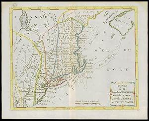
Ańadir al carrito(GN 30464) "Carte de la Nouvelle Angleterre New York Pensilvanie et Nouveau Jersay" rare original handcolored engraved map by Bellin from his Petit Atlas Maritime from 1764 size of sheet: ca.44 x34 cm (ca.17.3 x13.4 inches) with very small hole in middle fold otherwise in good condition Original! - No Copy! - No Reprint! Prepayment. - The Buyer pays for shipping. Insured and registered shipping worldwide. We combine shipping - if possible // Wir, das Antiquariat Steffen Völkel, kaufen und verkaufen alte Bücher, Handschriften, Zeichnungen, Autographen, Grafiken und Fotografien. Wir sind stets am Ankauf von kompletten Bibliotheken, Sammlungen und Nachlässen interessiert. Sprache: Französisch.
-

1787 - Antique Map USA NEW YORK JERSEY PHILADELPHIA by de la Tour (12)
Librería: Antique Paper Company, ASHFORD, KENT, Reino Unido
Calificación del vendedor: 3 de 5 estrellas
EUR 160,57
Envío por EUR 6,93
Se envía de Reino Unido a Estados Unidos de AmericaCantidad disponible: 1 disponibles
Ańadir al carritoListing Template 2018 Home About Us View Feedback Contact Us 1787 - Antique Map USA NEW YORK JERSEY PHILADELPHIA by de la Tour (12)Click image to enlargeDescription1787A fine and rare original antique maptitled' CARTE de la Nouvelle ANGLETERRE, Nouvelle YORK, Nouvelle JERSEY et PENSILVANIE'Highly detailed regional map of the Northern British Colonies, featuring numerous place names, forts, Native American tribes, rivers, coastal banks, and other details.Bucks County features prominently north of Philadelphia. Bucks County is one of the three original counties created by colonial proprietor William Pennin 1682. Penn named the county afterBuckinghamshire, the county where he lived in England. He built a country estate called Pennsbury Manorin Falls Township, Bucks County.Published for Atlas ou Collection de cartes Geographiques pour l'intelligence duu voyageur francois published by Joseph de Laporte.CARTOGRAPHERLouis Brion de la Tour (1743-1803)was the Cartographer Royal to the king of France. His official title was King's Engineer Geographer.Although he wasa prolific geographer, very little is currently known of his life or his career. His life was spent in scientific work. However what is known is an important part of his work was done in collaboration with Louis Charles Desnos (1750-1790 to) a bookseller and geographical engineer for the globes and spheres of His Danish Majesty. His son, Louis Brion de la Tour, a pupil of Jean-Bernard Restout, was engraver of maps and documents of the Revolution and was also an occasional painter of oil painters.PUBLISHERJoseph de Laporte (1714 - 1779)was an 18th Century French Priest, litarary critic, poet, playwright and prolific author.and#8203;Overall size of themapis 25cmx 20cmwith large margins central fold as issued. View Our Categories Decorative Prints World Wide Maps Scotland Maps Architecture Design England Maps Royalty About UsWe specialise in selling all items that can be considered to be Antique Paper. * PRINTS * MAPS * HISTORICAL DOCUMENTS * POSTAL HISTORY * BOOKS * POSTERS * STAMPS * POSTCARDS * EPHEMERA And anything else that is considered Antique and made of Paper. ALL OF OUR ITEMS ARE ORIGINAL ANTIQUES - NOT MODERN COPIES. We are also very keen buyers of anything similar and especially after better collections, original archives, whole libraries and better single items and have ÂŁ250,000 in cash funds at anyone time to buy the right items. Contact UsIf you have any questions then please do not hesitate to contact us through the eBay messaging system. Feedback We will always help you to have a 100% positive happy buying experience. Contact us if you are unhappy about any aspect of your purchase from us. We only want five star feedback from you so buy with confidence.
-
1787 - Original Antique Map USA NEW YORK JERSEY PHILADELPHIA by de la Tour (12)
Librería: Antique Paper Company, ASHFORD, KENT, Reino Unido
Calificación del vendedor: 3 de 5 estrellas
EUR 202,20
Envío por EUR 6,93
Se envía de Reino Unido a Estados Unidos de AmericaCantidad disponible: 1 disponibles
Ańadir al carrito1787 A fine and rare original antique map titled ' CARTE de la Nouvelle ANGLETERRE, Nouvelle YORK, Nouvelle JERSEY et PENSILVANIE ' PROVENANCE Taken from ATLAS OU COLLECTION DE CARTES GEOGRAPHIQUES POUR L'INTELLIGENCE DU VOYAGEUR FRANCOIS published by Joseph de Laporte. Highly detailed regional map of the Northern British Colonies, featuring numerous place names, forts, Native American tribes, rivers, coastal banks, and other details. Bucks County features prominently north of Philadelphia. Bucks County is one of the three original counties created by colonial proprietor William Penn in 1682. Penn named the county after Buckinghamshire, the county where he lived in England. He built a country estate called Pennsbury Manor in Falls Township, Bucks County. CARTOGRAPHER Louis Brion de la Tour (c1743 - 1803) was the Cartographer Royal to the King of France. There is little information about his life. His official title was King's Engineer Geographer. Although he is a prolific geographer, very little is currently known of his life or his career. His life was spent in scientific work. However what is known is an important part of his work was done in collaboration with Louis Charles Desnos (1750-1790 to) a bookseller and geographical engineer for the globes and spheres of His Danish Majesty. His son Louis Brion de la Tour, a pupil of Jean-Bernard Restout, was engraver of maps and documents of the Revolution, and was also an occasional portrait oil paintings. PUBLISHER Joseph de Laporte (1714 - 1779) was an 18th Century French Priest, litarary critic, poet, playwright and prolific author. Overall size of the map is 25cm x 20cm with large margins, perfect for mounting & framing CONDITION: Excellent overall condition with contemporary hand colouring and the usual centrefold, as issued. Blank on verso. As would be expected with antique maps of nearly 230 years old, there will be some slight ageing and toning, but once mou.
-

Antique Map of New Jersey
Librería: Bartele Gallery - The Netherlands, Langweer, FRL, Holanda
Miembro de asociación: ILAB NVVA
Calificación del vendedor: 5 de 5 estrellas
EUR 200,00
Envío por EUR 17,00
Se envía de Holanda a Estados Unidos de AmericaCantidad disponible: 1 disponibles
Ańadir al carritoAntique map titled 'Colton's New Jersey'. This rare hand colored map of New Jersey is a copper plate engraving dating to 1855. Produced by the important mid 19th century American map publisher J. H. Colton. Covers the region in considerable detail, documenting roads, railroads, canals, counties and topographical features. This map originates from 'Colton's General Atlas Of The World'. Published 1855.
-

Original Antique Map of the State of New Jersey Published in France
Librería: Bartele Gallery - The Netherlands, Langweer, FRL, Holanda
Miembro de asociación: ILAB NVVA
Calificación del vendedor: 5 de 5 estrellas
EUR 200,00
Envío por EUR 17,00
Se envía de Holanda a Estados Unidos de AmericaCantidad disponible: 1 disponibles
Ańadir al carritoOriginal antique map titled 'Carte Géographique Statistique et Historique du New-Jersey'. One of the earliest obtainable maps of the State of New Jersey published outside of the United States. The map appeared in Buchon's edition of Carey & Lea's Atlas, which was highly prized not only for its cartographic information but the marvelous information about each of the states and territories included. The atlas was issued in 6 editions in English, French & German between 1822 and 1827. The French edition is a completely revised map, with better engraving quality than the original Philadelphia edition.
-

Antique Map of New Jersey, Delaware and Maryland by Johnson, 1872
Librería: Bartele Gallery - The Netherlands, Langweer, FRL, Holanda
Miembro de asociación: ILAB NVVA
Calificación del vendedor: 5 de 5 estrellas
EUR 300,00
Envío por EUR 17,00
Se envía de Holanda a Estados Unidos de AmericaCantidad disponible: 1 disponibles
Ańadir al carritoAntique map titled 'Johnson's New Jersey (.). Two maps on one sheet showing New Jersey, Delaware and Maryland. With inset map of the district of Columbia. This map originates from 'Johnson's New Illustrated Family Atlas of the World' by A.J. Johnson. Published 1872.
-

Antique Map of Pennsylvania and New Jersey by Johnson, 1872
Librería: Bartele Gallery - The Netherlands, Langweer, FRL, Holanda
Miembro de asociación: ILAB NVVA
Calificación del vendedor: 5 de 5 estrellas
EUR 320,00
Envío por EUR 17,00
Se envía de Holanda a Estados Unidos de AmericaCantidad disponible: 1 disponibles
Ańadir al carritoAntique map titled 'Johnson's Pennsylvania and New Jersey'. Original map showing Pennsylvania and New Jersey. This map originates from 'Johnson's New Illustrated Family Atlas of the World' by A.J. Johnson. Published 1872.
-
New Jersey Antique Map ? The Garden State, Railroads & Counties, c.1888
Librería: Bartele Gallery - The Netherlands, Langweer, FRL, Holanda
Miembro de asociación: ILAB NVVA
Calificación del vendedor: 5 de 5 estrellas
EUR 460,00
Envío por EUR 17,00
Se envía de Holanda a Estados Unidos de AmericaCantidad disponible: 1 disponibles
Ańadir al carritoAntique Map of New Jersey ? Rand McNally, circa 1888 This antique map of New Jersey was published by Rand, McNally & Co. around 1888. It offers a detailed late 19th-century portrait of the Garden State, highlighting its counties, towns, railroads, and waterways, as well as the critical links to New York and Philadelphia. The map shows the entire state of New Jersey, with counties finely outlined and towns and villages clearly labeled. Railroads dominate the map, marked in red and blue, underscoring the state's role as a transportation corridor between major metropolitan centers. The dense networks around Newark, Jersey City, Camden, and Trenton illustrate New Jersey's rapid industrial and suburban growth during the Gilded Age. Particularly appealing are the insets, including a detailed map of New York City and adjacent New Jersey, and an inset of the southern portion of the state. These provide a closer look at the heavily urbanized and economically vital areas, making this map both functional and decorative. The Atlantic coast, from Sandy Hook to Cape May, is carefully engraved, reflecting New Jersey's role as both a shipping hub and a seaside destination. Together, the geographic, industrial, and coastal elements capture the dynamic identity of New Jersey in the late 1800s. Condition report: Very good condition with mild toning and clean margins. Original center fold as issued with faint darkening along the crease. Plate mark visible. Strong impression with crisp detail and attractive insets. Framing tips: A black or walnut frame with an ivory mat will emphasize the map's engraving. A double mat with ivory outer and pale blue inner will draw attention to the Atlantic coastline and New York Harbor inset, making for a striking display. Technique: Lithograph with original outline color Maker: Rand, McNally & Co., Chicago, circa 1888.


