
Importe total (1 artículo artículos):
Destino del pedido:

antique map alabama (11 resultados)
Ir a los resultados principales
Filtros de búsqueda
Tipo de artículo
- Todos los tipos de productos
- Libros (6)
- Revistas y publicaciones (No hay ningún otro resultado que coincida con este filtro.)
- Cómics (No hay ningún otro resultado que coincida con este filtro.)
- Partituras (No hay ningún otro resultado que coincida con este filtro.)
- Arte, grabados y pósters (No hay ningún otro resultado que coincida con este filtro.)
- Fotografías (No hay ningún otro resultado que coincida con este filtro.)
- Mapas (5)
- Manuscritos y coleccionismo de papel (No hay ningún otro resultado que coincida con este filtro.)
Condición Más información
- Nuevo (No hay ningún otro resultado que coincida con este filtro.)
- Como nuevo, Excelente o Muy bueno (No hay ningún otro resultado que coincida con este filtro.)
- Bueno o Aceptable (3)
- Regular o Pobre (No hay ningún otro resultado que coincida con este filtro.)
- Tal como se indica (8)
Encuadernación
- Todas
- Tapa dura (No hay ningún otro resultado que coincida con este filtro.)
- Tapa blanda (No hay ningún otro resultado que coincida con este filtro.)
Más atributos
- Primera edición (No hay ningún otro resultado que coincida con este filtro.)
- Firmado (No hay ningún otro resultado que coincida con este filtro.)
- Sobrecubierta (No hay ningún otro resultado que coincida con este filtro.)
- Con imágenes (8)
- No impresión bajo demanda (11)
Idioma (2)
Precio
- Cualquier precio
- Menos de EUR 20 (No hay ningún otro resultado que coincida con este filtro.)
- EUR 20 a EUR 45
- Más de EUR 45
Gastos de envío gratis
- Envío gratis a Estados Unidos de America (No hay ningún otro resultado que coincida con este filtro.)
Ubicación del vendedor
Valoración de los vendedores
-

North America - Parts of Louisiana, Arkansas, Mississippi, Alabama and Florida - an Antique Map
Idioma: Inglés
Librería: K Books Ltd ABA ILAB, York, YORKS, Reino Unido
Miembro de asociación: ABA ILAB PBFA
Calificación del vendedor: 5 de 5 estrellas

EUR 35,71
Envío por EUR 22,53
Se envía de Reino Unido a Estados Unidos de AmericaCantidad disponible: 1 disponibles
Ańadir al carritoNo Binding. Condición: Very Good. Engraved By Walker Ilustrador. A fine antique map in very good condition - printed in circa 1844. Mounted (matted) and ready to frame. Engraved size approx 16 x 13 Ins, 41 x 33 Cms. Mounted size approx 19 x 16 in, 49 x 41cm. Coloured in outline, hand colouring contemporary. A fine engraved map of North America - Parts of Louisiana, Arkansas, Mississippi, Alabama and Florida.
-
North America - Georgia, Parts of north and Ocuth Carolina, Tennessee, Alabama and Florida - an Antique Map
Idioma: Inglés
Librería: K Books Ltd ABA ILAB, York, YORKS, Reino Unido
Miembro de asociación: ABA ILAB PBFA
Calificación del vendedor: 5 de 5 estrellas
EUR 35,71
Envío por EUR 22,53
Se envía de Reino Unido a Estados Unidos de AmericaCantidad disponible: 1 disponibles
Ańadir al carritoNo Binding. Condición: Very Good. Engraved By Walker Ilustrador. A fine antique map in very good condition - printed in circa 1844. Mounted (matted) and ready to frame. Engraved size approx 16 x 13 Ins, 41 x 33 Cms. Mounted size approx 19 x 16 in, 49 x 41cm. Coloured in outline, hand colouring contemporary. A fine engraved map of North America - Georgia, Parts of north and Ocuth Carolina, Tennessee, Alabama and Florida.
-
North America - with part of Missouri, Illanois , Kentucky, Tennessee, Alabama Arkansas - an Antique Map
Idioma: Inglés
Librería: K Books Ltd ABA ILAB, York, YORKS, Reino Unido
Miembro de asociación: ABA ILAB PBFA
Calificación del vendedor: 5 de 5 estrellas
EUR 35,71
Envío por EUR 22,53
Se envía de Reino Unido a Estados Unidos de AmericaCantidad disponible: 1 disponibles
Ańadir al carritoNo Binding. Condición: Very Good. Engraved By Walker Ilustrador. A fine antique map in very good condition - printed in circa 1844. Mounted (matted) and ready to frame. Engraved size approx 16 x 13 Ins, 41 x 33 Cms. Mounted size approx 19 x 16 in, 49 x 41cm. Coloured in outline, hand colouring contemporary. A fine engraved map of North America - with part of Missouri, Illanois , Kentucky, Tennessee, Alabama Arkansas.
-
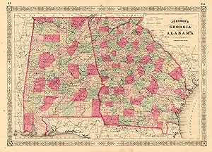
Johnson's Georgia and Alabama Johnson & Ward Johnson's Georgia and Alabama Antique Map, Lithograph 395 x 560mm New York 1863
Publicado por New York, 1863
Librería: Antiquariat Reinhold Berg eK Inh. R.Berg, Regensburg, Alemania
Miembro de asociación: ILAB VDA
Calificación del vendedor: 5 de 5 estrellas
Mapa
EUR 65,00
Envío por EUR 24,00
Se envía de Alemania a Estados Unidos de AmericaCantidad disponible: 1 disponibles
Ańadir al carritoOther. Lithograph, hand-colored in outline by Johnson & Ward, published 1863 by New York. Image size: 395 by 560mm (15 by 22 inches). From Johnson's New Illustrated Family Atlas the leading American atlas of the Civil War era. A.J. Johnson (Alvin Jewett Johnson, 18271884) was a New York publisher who created one of the most popular American atlas series of the mid-19th century. Having acquired the plates from Joseph H. Colton in 1860, Johnson produced Johnson's New Illustrated Family Atlas in many editions, partnering first with Browning and then with Benjamin P. Ward (Johnson & Ward, 18631866). The Family Atlas went through numerous editions during and after the Civil War, incorporating the latest geographic, railroad, and statistical information. Johnson's maps were engraved on steel with the finest detail available and are distinguished by their vivid hand-applied outline coloring. They are today among the most recognizable and collectible American antique maps of the 19th century.This antique map shows the southern states Georgia and Alabama. Inside the map are many place names, rivers, etc. Detailed map of Georgia and Alabama, the two southern states divided up into counties in fine hand color. In very good to excellent condition. Two minor brown spots, one within the image of the map. In very good to excellent condition. Two minor brown spots, one within the image of the map. 395 by 560mm (15 by 22 inches). 395 by 560mm (15 by 22 inches).
-

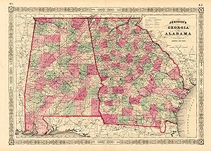
Johnson's Georgia and Alabama Johnson & Browning Johnson's Georgia and Alabama Antique Map, Lithograph 395 x 560mm New York 1859
Publicado por New York, 1859
Librería: Antiquariat Reinhold Berg eK Inh. R.Berg, Regensburg, Alemania
Miembro de asociación: ILAB VDA
Calificación del vendedor: 5 de 5 estrellas
Mapa
EUR 65,00
Envío por EUR 24,00
Se envía de Alemania a Estados Unidos de AmericaCantidad disponible: 1 disponibles
Ańadir al carritoOther. Lithograph, hand-colored in outline by Johnson & Browning, published 1859 by New York. Image size: 395 by 560mm (15 by 22 inches). From Johnson's New Illustrated Family Atlas the leading American atlas of the Civil War era. A.J. Johnson (Alvin Jewett Johnson, 18271884) launched his celebrated atlas series after acquiring Colton's plates in 1860, initially publishing as Johnson & Browning before reorganizing as Johnson & Ward in 1863. Johnson's New Illustrated Family Atlas became the dominant American commercial atlas of the Civil War era, offering detailed steel-engraved state and regional maps with vivid hand-applied outline coloring. These atlases were sold by subscription and reached a vast American audience, making them among the most widely distributed and today most collectible American maps of the 19th century.This antique map shows the southern states Georgia and Alabama. Inside the map are many place names, rivers, etc. The map has in the upper right and left corner insets, which show the Rice-Mill on Savannah River and the Tuscaloosa Observatory. In very good to excellent condition. Two minor brown spots, one within the image of the map. In very good to excellent condition. Two minor brown spots, one within the image of the map. 395 by 560mm (15 by 22 inches). 395 by 560mm (15 by 22 inches).
-
Johnson's Georgia and Alabama published by Johnson and Ward. Johnson & Ward Johnson's Georgia and Alabama published by Johnson and. Antique Map, Lithograph 394 x 562mm Johnson & Ward, New York 1865
Publicado por Johnson & Ward, New York, 1865
Librería: Antiquariat Reinhold Berg eK Inh. R.Berg, Regensburg, Alemania
Miembro de asociación: ILAB VDA
Calificación del vendedor: 5 de 5 estrellas
Mapa
EUR 95,00
Envío por EUR 24,00
Se envía de Alemania a Estados Unidos de AmericaCantidad disponible: 1 disponibles
Ańadir al carritoOther. Lithograph, original color in outline by Johnson & Ward, published 1865 by Johnson & Ward, New York. Image size: 394 by 562mm (15 by 22 inches). From Johnson's New Illustrated Family Atlas the leading American atlas of the Civil War era. A.J. Johnson (Alvin Jewett Johnson, 18271884) was a New York publisher who created one of the most popular American atlas series of the mid-19th century. Having acquired the plates from Joseph H. Colton in 1860, Johnson produced Johnson's New Illustrated Family Atlas in many editions, partnering first with Browning and then with Benjamin P. Ward (Johnson & Ward, 18631866). The Family Atlas went through numerous editions during and after the Civil War, incorporating the latest geographic, railroad, and statistical information. Johnson's maps were engraved on steel with the finest detail available and are distinguished by their vivid hand-applied outline coloring. They are today among the most recognizable and collectible American antique maps of the 19th century.This antique map of Johnson's Georgia and Alabama published by Johnson and Ward was published in 1865 by Johnson & Ward, New York (394 by 562mm (15 by 22 inches).). It is printed as a lithograph, original color in outline. The map documents the region with careful attention to rivers, settlements, roads, and political boundaries, reflecting the geographical knowledge available at the time of publication and offering an invaluable primary source for historians and collectors of North American antique cartography. In very good condition. In very good condition. 394 by 562mm (15 by 22 inches). 394 by 562mm (15 by 22 inches).
-

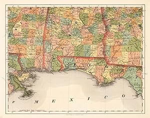
North America Sheet XIII Parts of Louisiana, Arkansas, Mississippi, Alabama & Florida. SDUK (Society for the diffusion of useful knowledge) North America Sheet XIII Parts of Louisiana, Arkansas. Antique Map, Steel Engraving 305 x 410mm.
Publicado por Baldwin & Cradock, London, 1833
Librería: Antiquariat Reinhold Berg eK Inh. R.Berg, Regensburg, Alemania
Miembro de asociación: ILAB VDA
Calificación del vendedor: 5 de 5 estrellas
Mapa
EUR 110,00
Envío por EUR 24,00
Se envía de Alemania a Estados Unidos de AmericaCantidad disponible: 1 disponibles
Ańadir al carritoOther. Steel Engraving, hand-colored in outline by SDUK (Society for the diffusion of useful knowledge), published 1833 by Baldwin & Cradock, London. Image size: 305 by 410mm (12 by 16 inches). From the celebrated SDUK series widely regarded as among the finest steel-engraved maps of the 19th century. The Society for the Diffusion of Useful Knowledge (SDUK) was a Whig organization founded in London in 1826 with the admirable goal of making information accessible to the working and middle classes. Its map committee began publishing in 1829, producing a celebrated series of finely engraved steel maps initially under the Baldwin & Cradock imprint, later reissued by Chapman & Hall (from 1844) and Charles Knight. The SDUK maps are renowned for their exceptional precision, elegant typography, and fine steel engraving widely considered among the finest examples of British cartography from the first half of the 19th century. Their North American sheets were produced at a transformative moment in the continent's history, making them invaluable historical documents as well as beautiful collector objects.This North America map shows Parts of Louisiana, Arkansas, Mississippi, Alabama & Florida. The title is in the lower right corner. The mileage scale is on the left sider outside the engraving. In excellent condition. 305 by 410mm (12 by 16 inches). In excellent condition. 305 by 410mm (12 by 16 inches). 305 by 410mm (12 by 16 inches).
-
Alabama, Florida No: 14 Smith, J. Calvin Alabama, Florida No: 14 Antique Map, Lithograph 370 x 470mm Theodor Fischer, Kassel 1855-60
Publicado por Theodor Fischer 1855-60, Kassel, 1855
Librería: Antiquariat Reinhold Berg eK Inh. R.Berg, Regensburg, Alemania
Miembro de asociación: ILAB VDA
Calificación del vendedor: 5 de 5 estrellas
Mapa
EUR 268,00
Envío por EUR 24,00
Se envía de Alemania a Estados Unidos de AmericaCantidad disponible: 1 disponibles
Ańadir al carritoOther. Lithograph, original color in outline by Smith, J. Calvin, published 1855-60 by Theodor Fischer, Kassel. Image size: 370 by 470mm (14 by 18 inches). From Smith's multi-sheet Special-Karte one of the most detailed and accurate mid-19th-century maps of the United States. John Calvin (J. Calvin) Smith (c.18091890) was an American surveyor, geographer, and engraver active in New York City from the 1840s. Working with partners including George Sherman (under the Sherman & Smith imprint, 18401853) and later in association with J.H. Colton, Smith produced some of the most accurate and widely used general-purpose maps of the United States of his era. His maps appeared in government publications, military surveys, and commercial atlases, and his multi-sheet Special-Karte der Vereinigten Staaten (published in a German-language edition) brought American cartographic standards to European audiences. Despite his prolific output and importance to American cartographic history, much of Smith's personal biography remains obscure.This antique map of Alabama, Florida No: 14 was published in 1855-60 by Theodor Fischer, Kassel (370 by 470mm (14 by 18 inches).). It is printed as a lithograph, original color in outline. The map documents the region with careful attention to rivers, settlements, roads, and political boundaries, reflecting the geographical knowledge available at the time of publication and offering an invaluable primary source for historians and collectors of North American antique cartography. In excellent condition. In excellent condition. 370 by 470mm (14 by 18 inches). 370 by 470mm (14 by 18 inches).
-

Antique Map of Alabama
Librería: Bartele Gallery - The Netherlands, Langweer, FRL, Holanda
Miembro de asociación: ILAB NVVA
Calificación del vendedor: 5 de 5 estrellas
EUR 290,00
Envío por EUR 17,00
Se envía de Holanda a Estados Unidos de AmericaCantidad disponible: 1 disponibles
Ańadir al carritoAntique map titled 'Alabama'. Original antique map of Alabama, United States. This print originates from 'Encyclopaedia Britannica', Ninth Edition. Published 1875. The Encyclopćdia Britannica has been published continuously since 1768, appearing in fifteen official editions. Several editions have been amended with multi-volume "supplements" (3rd, 5th/6th), consisted of previous editions with added supplements (10th, and 12th/13th) or gone drastic re-organizations (15th). In recent years, digital versions of the Britannica have been developed, both online and on optical media. Since the early 1930s, the Britannica has developed several "spin-off" products to leverage its reputation as a reliable reference work and educational tool. The Encyclopedia as known up to 2012 was incurring unsustainable losses and the print editions were ended, but it continues on the Internet.
-
Alabama Antique Map 1888 ? The Heart of Dixie, Railroads & Towns
Librería: Bartele Gallery - The Netherlands, Langweer, FRL, Holanda
Miembro de asociación: ILAB NVVA
Calificación del vendedor: 5 de 5 estrellas
EUR 460,00
Envío por EUR 17,00
Se envía de Holanda a Estados Unidos de AmericaCantidad disponible: 1 disponibles
Ańadir al carritoAlabama Map 1888 ? Rand McNally Antique Lithograph This antique 1888 map of Alabama, published by Rand, McNally & Co., provides a highly detailed view of the state during a period of industrial expansion and agricultural reliance. The map shows counties, towns, railroads, and rivers, illustrating Alabama at a time when railroads were reshaping its economy and connecting the state to broader national trade networks. Counties are neatly engraved with county seats marked, from the fertile Black Belt counties of Dallas, Perry, and Marengo to the northern regions around Madison, Limestone, and Lauderdale. Major cities such as Montgomery, Birmingham, Mobile, and Huntsville are prominently shown, along with countless smaller towns and settlements that had developed along railway lines and rivers. Railroads, printed in red and blue, dominate the map, highlighting the state's growing transportation infrastructure. Lines such as the Louisville & Nashville Railroad, the Alabama Great Southern, and the East Tennessee, Virginia & Georgia Railroad are all represented. These connections underscored Birmingham's rapid rise as an industrial center based on coal, iron, and steel, while Mobile continued to function as a vital Gulf Coast port for cotton and lumber exports. The state's natural features are also carefully marked, with rivers including the Alabama, Tombigbee, and Tennessee playing central roles in both transportation and agriculture. The Gulf of Mexico coastline with Mobile Bay is clearly delineated, showing the port city's crucial place in international trade. This map is an excellent example of Rand, McNally's cartographic precision, designed both for practical reference and as a historical record. It illustrates Alabama in the post-Reconstruction era, as it transitioned into a more industrialized economy while still deeply tied to agriculture. For collectors, genealogists, and historians of the American South, this 1888 Alabama map offers a valuable snapshot of the state's infrastructure and settlement during an important moment of transformation. Condition: Very good, with light age toning and mild foxing, mostly in margins. Center fold as issued. Paper strong with plate mark visible; no tears or major damage. Framing tips: A dark wood or black frame with a cream mat will highlight the density of the railroad network. For added emphasis, a secondary mat in red can draw attention to the railway routes. Technique: Lithograph with printed detail Maker: Rand, McNally & Co., Chicago, 1888 Special note: Maps of Southern states like Alabama from the late 19th century are especially appealing to collectors, as they capture both the agricultural Black Belt and the emergence of new industrial centers such as Birmingham. They also highlight the role of railroads in reshaping the post-Reconstruction South.
-

Antique Map of Tennessee, Kentucky, Virginia, Alabama, Georgia and Surroundings
Librería: Bartele Gallery - The Netherlands, Langweer, FRL, Holanda
Miembro de asociación: ILAB NVVA
Calificación del vendedor: 5 de 5 estrellas
EUR 720,00
Envío por EUR 17,00
Se envía de Holanda a Estados Unidos de AmericaCantidad disponible: 1 disponibles
Ańadir al carritoAntique map of part of the United States showing Alabama, Georgia, North Carolina, South Carolina, Tennessee, Kentucky, Virginia and part of Florida. With inset maps of the southern part of Florida and the southern part of Texas. This map was part of a set of six individual sheets with maps of the United States and North America. This map originates from Stielers Handatlas, published circa 1874. Stielers Handatlas (after Adolf Stieler, 1775?1836), formally titled Hand-Atlas über alle Theile der Erde und über das Weltgebäude (Handy atlas of all parts of the world and of the universe), was the leading German world atlas of the last three decades of the 19th and the first half of the 20th century. Published by Justus Perthes of Gotha (established 1785 and still existing there) it went through ten editions from 1816 to 1945. As with many 19th century publications, an edition was issued in parts; for example, the eighth edition was issued in 32 monthly parts.

