
Importe total (1 artículo artículos):
Destino del pedido:

1892 large colour antique map (26 resultados)
Ir a los resultados principales
Filtros de búsqueda
Tipo de artículo
- Todos los tipos de productos
- Libros (26)
- Revistas y publicaciones (No hay ningún otro resultado que coincida con este filtro.)
- Cómics (No hay ningún otro resultado que coincida con este filtro.)
- Partituras (No hay ningún otro resultado que coincida con este filtro.)
- Arte, grabados y pósters (No hay ningún otro resultado que coincida con este filtro.)
- Fotografías (No hay ningún otro resultado que coincida con este filtro.)
- Mapas (No hay ningún otro resultado que coincida con este filtro.)
- Manuscritos y coleccionismo de papel (No hay ningún otro resultado que coincida con este filtro.)
Condición Más información
- Nuevo (No hay ningún otro resultado que coincida con este filtro.)
- Como nuevo, Excelente o Muy bueno (No hay ningún otro resultado que coincida con este filtro.)
- Bueno o Aceptable (No hay ningún otro resultado que coincida con este filtro.)
- Regular o Pobre (No hay ningún otro resultado que coincida con este filtro.)
- Tal como se indica (26)
Encuadernación
- Todas
- Tapa dura (No hay ningún otro resultado que coincida con este filtro.)
- Tapa blanda (No hay ningún otro resultado que coincida con este filtro.)
Más atributos
- Primera edición (No hay ningún otro resultado que coincida con este filtro.)
- Firmado (No hay ningún otro resultado que coincida con este filtro.)
- Sobrecubierta (No hay ningún otro resultado que coincida con este filtro.)
- Con imágenes (24)
- No impresión bajo demanda (26)
Idioma (1)
Precio
- Cualquier precio
- Menos de EUR 20 (No hay ningún otro resultado que coincida con este filtro.)
- EUR 20 a EUR 45
- Más de EUR 45
Gastos de envío gratis
- Envío gratis a Estados Unidos de America (No hay ningún otro resultado que coincida con este filtro.)
Ubicación del vendedor
Valoración de los vendedores
-

1892 Large Colour Antique Map of AMĂRIQUE DU SUD South America (NAI/60)
Librería: Antique Paper Company, ASHFORD, KENT, Reino Unido
Calificación del vendedor: 2 de 5 estrellas

EUR 28,67
Envío por EUR 6,96
Se envía de Reino Unido a Estados Unidos de AmericaCantidad disponible: 1 disponibles
Ańadir al carritoListing Template 2018 Home About Us View Feedback Contact Us 1892 Large Colour Antique Map of AMĂRIQUE DU SUD South America (NAI/60)Click image to enlargeDescription1892Large original colourmap titled:AMand#201;RIQUE DU SUDA fine colour map of SOUTH AMERICA.With a vignetteview of BAIE DE RIO-DE-JANEIRO.ProvenanceTaken from 'NOUVEL ATLAS ILLUSTRE Geographie Universelle' published by Direction Et Administration, 11, Rue du Moulin-Vert, Paris, 1892Excellent conditionwith central fold as issued.Size of mapapprox 52cm x 39cm (20.5in x 15.5in) including margins. View Our Categories Decorative Prints World Wide Maps Scotland Maps Architecture Design England Maps Royalty About UsWe specialise in selling all items that can be considered to be Antique Paper. * PRINTS * MAPS * HISTORICAL DOCUMENTS * POSTAL HISTORY * BOOKS * POSTERS * STAMPS * POSTCARDS * EPHEMERA And anything else that is considered Antique and made of Paper. ALL OF OUR ITEMS ARE ORIGINAL ANTIQUES - NOT MODERN COPIES. We are also very keen buyers of anything similar and especially after better collections, original archives, whole libraries and better single items and have ÂŁ250,000 in cash funds at anyone time to buy the right items. Contact UsIf you have any questions then please do not hesitate to contact us through the eBay messaging system. Feedback We will always help you to have a 100% positive happy buying experience. Contact us if you are unhappy about any aspect of your purchase from us. We only want five star feedback from you so buy with confidence.
-

1892 Large Colour Antique Map ALLEMAGNE DU SUD Southern Germany Munich (NAI/37)
Librería: Antique Paper Company, ASHFORD, KENT, Reino Unido
Calificación del vendedor: 2 de 5 estrellas
EUR 28,67
Envío por EUR 6,96
Se envía de Reino Unido a Estados Unidos de AmericaCantidad disponible: 1 disponibles
Ańadir al carritoListing Template 2018 Home About Us View Feedback Contact Us 1892 Large Colour Antique Map ALLEMAGNE DU SUD Southern Germany Munich (NAI/37)Click image to enlargeDescription1892Large original colourmap titled:ALLEMAGNE DU SUDA fine colour map of SOUTHERNGERMANY. With avignetteviewof MUNICH.ProvenanceTaken from 'NOUVEL ATLAS ILLUSTRE Geographie Universelle' published by Direction Et Administration, 11, Rue du Moulin-Vert, Paris, 1892Excellent conditionwith central fold as issued.Size of mapapprox 52cm x 39cm (20.5in x 15.5in) including margins. View Our Categories Decorative Prints World Wide Maps Scotland Maps Architecture Design England Maps Royalty About UsWe specialise in selling all items that can be considered to be Antique Paper. * PRINTS * MAPS * HISTORICAL DOCUMENTS * POSTAL HISTORY * BOOKS * POSTERS * STAMPS * POSTCARDS * EPHEMERA And anything else that is considered Antique and made of Paper. ALL OF OUR ITEMS ARE ORIGINAL ANTIQUES - NOT MODERN COPIES. We are also very keen buyers of anything similar and especially after better collections, original archives, whole libraries and better single items and have ÂŁ250,000 in cash funds at anyone time to buy the right items. Contact UsIf you have any questions then please do not hesitate to contact us through the eBay messaging system. Feedback We will always help you to have a 100% positive happy buying experience. Contact us if you are unhappy about any aspect of your purchase from us. We only want five star feedback from you so buy with confidence.
-

1892 Large Colour Antique Map FRANCE POLITIQUE Political France Paris (NAI/20)
Librería: Antique Paper Company, ASHFORD, KENT, Reino Unido
Calificación del vendedor: 2 de 5 estrellas
EUR 28,67
Envío por EUR 6,96
Se envía de Reino Unido a Estados Unidos de AmericaCantidad disponible: 1 disponibles
Ańadir al carritoListing Template 2018 Home About Us View Feedback Contact Us 1892 Large Colour Antique Map FRANCE POLITIQUE Political France Paris (NAI/20)Click image to enlargeDescription1892Large original colourmap titled:FRANCE POLITIQUEA fine colour POLITICALMAP OF FRANCE. With a vignette view ofPARIS.ProvenanceTaken from 'NOUVEL ATLAS ILLUSTRE Geographie Universelle' published by Direction Et Administration, 11, Rue du Moulin-Vert, Paris, 1892Excellent conditionwith central fold as issued.Size of mapapprox 52cm x 39cm (20.5in x 15.5in) including margins. View Our Categories Decorative Prints World Wide Maps Scotland Maps Architecture Design England Maps Royalty About UsWe specialise in selling all items that can be considered to be Antique Paper. * PRINTS * MAPS * HISTORICAL DOCUMENTS * POSTAL HISTORY * BOOKS * POSTERS * STAMPS * POSTCARDS * EPHEMERA And anything else that is considered Antique and made of Paper. ALL OF OUR ITEMS ARE ORIGINAL ANTIQUES - NOT MODERN COPIES. We are also very keen buyers of anything similar and especially after better collections, original archives, whole libraries and better single items and have ÂŁ250,000 in cash funds at anyone time to buy the right items. Contact UsIf you have any questions then please do not hesitate to contact us through the eBay messaging system. Feedback We will always help you to have a 100% positive happy buying experience. Contact us if you are unhappy about any aspect of your purchase from us. We only want five star feedback from you so buy with confidence.
-

1892 Large Colour Antique Map of FRANCE N.E North East France Belfort (NAI/22)
Librería: Antique Paper Company, ASHFORD, KENT, Reino Unido
Calificación del vendedor: 2 de 5 estrellas
EUR 32,86
Envío por EUR 6,96
Se envía de Reino Unido a Estados Unidos de AmericaCantidad disponible: 1 disponibles
Ańadir al carritoListing Template 2018 Home About Us View Feedback Contact Us 1892 Large Colour Antique Map of FRANCE N.E North East France Belfort (NAI/22)Click image to enlargeDescription1892Large original colourmap titled:FRANCE N.EA fine colour MAP OF NORTH EASTFRANCE. With a vignette view ofBELFORT.ProvenanceTaken from 'NOUVEL ATLAS ILLUSTRE Geographie Universelle' published by Direction Et Administration, 11, Rue du Moulin-Vert, Paris, 1892Excellent conditionwith central fold as issued.Size of mapapprox 52cm x 39cm (20.5in x 15.5in) including margins. View Our Categories Decorative Prints World Wide Maps Scotland Maps Architecture Design England Maps Royalty About UsWe specialise in selling all items that can be considered to be Antique Paper. * PRINTS * MAPS * HISTORICAL DOCUMENTS * POSTAL HISTORY * BOOKS * POSTERS * STAMPS * POSTCARDS * EPHEMERA And anything else that is considered Antique and made of Paper. ALL OF OUR ITEMS ARE ORIGINAL ANTIQUES - NOT MODERN COPIES. We are also very keen buyers of anything similar and especially after better collections, original archives, whole libraries and better single items and have ÂŁ250,000 in cash funds at anyone time to buy the right items. Contact UsIf you have any questions then please do not hesitate to contact us through the eBay messaging system. Feedback We will always help you to have a 100% positive happy buying experience. Contact us if you are unhappy about any aspect of your purchase from us. We only want five star feedback from you so buy with confidence.
-

1892 Large Colour Antique Map of SUISSE Switzerland Vignette View Berne (NAI/33)
Librería: Antique Paper Company, ASHFORD, KENT, Reino Unido
Calificación del vendedor: 2 de 5 estrellas
EUR 32,86
Envío por EUR 6,96
Se envía de Reino Unido a Estados Unidos de AmericaCantidad disponible: 1 disponibles
Ańadir al carritoListing Template 2018 Home About Us View Feedback Contact Us 1892 Large Colour Antique Map of SUISSE Switzerland Vignette View Berne (NAI/33)Click image to enlargeDescription1892Large original colourmap titled:SUISSEA fine colour map of SWITZERLAND. With avignetteviewofBERNE.ProvenanceTaken from 'NOUVEL ATLAS ILLUSTRE Geographie Universelle' published by Direction Et Administration, 11, Rue du Moulin-Vert, Paris, 1892Excellent conditionwith central fold as issued.Size of mapapprox 52cm x 39cm (20.5in x 15.5in) including margins. View Our Categories Decorative Prints World Wide Maps Scotland Maps Architecture Design England Maps Royalty About UsWe specialise in selling all items that can be considered to be Antique Paper. * PRINTS * MAPS * HISTORICAL DOCUMENTS * POSTAL HISTORY * BOOKS * POSTERS * STAMPS * POSTCARDS * EPHEMERA And anything else that is considered Antique and made of Paper. ALL OF OUR ITEMS ARE ORIGINAL ANTIQUES - NOT MODERN COPIES. We are also very keen buyers of anything similar and especially after better collections, original archives, whole libraries and better single items and have ÂŁ250,000 in cash funds at anyone time to buy the right items. Contact UsIf you have any questions then please do not hesitate to contact us through the eBay messaging system. Feedback We will always help you to have a 100% positive happy buying experience. Contact us if you are unhappy about any aspect of your purchase from us. We only want five star feedback from you so buy with confidence.
-

1892 Large Colour Antique Map of ANGLETERRE England Londres London (NAI/26)
Librería: Antique Paper Company, ASHFORD, KENT, Reino Unido
Calificación del vendedor: 2 de 5 estrellas
EUR 32,86
Envío por EUR 6,96
Se envía de Reino Unido a Estados Unidos de AmericaCantidad disponible: 1 disponibles
Ańadir al carritoListing Template 2018 Home About Us View Feedback Contact Us 1892 Large Colour Antique Map of ANGLETERRE England Londres London (NAI/26)Click image to enlargeDescription1892Large original colourmap titled:ANGLETERREA fine colour map of ENGLAND. With a vignette view ofLONDRES (LONDON).ProvenanceTaken from 'NOUVEL ATLAS ILLUSTRE Geographie Universelle' published by Direction Et Administration, 11, Rue du Moulin-Vert, Paris, 1892Excellent conditionwith central fold as issued.Size of mapapprox 52cm x 39cm (20.5in x 15.5in) including margins. View Our Categories Decorative Prints World Wide Maps Scotland Maps Architecture Design England Maps Royalty About UsWe specialise in selling all items that can be considered to be Antique Paper. * PRINTS * MAPS * HISTORICAL DOCUMENTS * POSTAL HISTORY * BOOKS * POSTERS * STAMPS * POSTCARDS * EPHEMERA And anything else that is considered Antique and made of Paper. ALL OF OUR ITEMS ARE ORIGINAL ANTIQUES - NOT MODERN COPIES. We are also very keen buyers of anything similar and especially after better collections, original archives, whole libraries and better single items and have ÂŁ250,000 in cash funds at anyone time to buy the right items. Contact UsIf you have any questions then please do not hesitate to contact us through the eBay messaging system. Feedback We will always help you to have a 100% positive happy buying experience. Contact us if you are unhappy about any aspect of your purchase from us. We only want five star feedback from you so buy with confidence.
-

1892 Large Colour Antique Map FRANCE PHYSIQUE Map of Physical France (NAI/17)
Librería: Antique Paper Company, ASHFORD, KENT, Reino Unido
Calificación del vendedor: 2 de 5 estrellas
EUR 32,86
Envío por EUR 6,96
Se envía de Reino Unido a Estados Unidos de AmericaCantidad disponible: 1 disponibles
Ańadir al carritoListing Template 2018 Home About Us View Feedback Contact Us 1892 Large Colour Antique Map FRANCE PHYSIQUE Map of Physical France (NAI/17)Click image to enlargeDescription1892Large original colourmap titled:FRANCE PHYSIQUEA fine colour map showing PHYSICAL FRANCE. With a vignette view ofSAUT DU DOUBS.ProvenanceTaken from 'NOUVEL ATLAS ILLUSTRE Geographie Universelle' published by Direction Et Administration, 11, Rue du Moulin-Vert, Paris, 1892Excellent conditionwith central fold as issued.Size of mapapprox 52cm x 39cm (20.5in x 15.5in) including margins. View Our Categories Decorative Prints World Wide Maps Scotland Maps Architecture Design England Maps Royalty About UsWe specialise in selling all items that can be considered to be Antique Paper. * PRINTS * MAPS * HISTORICAL DOCUMENTS * POSTAL HISTORY * BOOKS * POSTERS * STAMPS * POSTCARDS * EPHEMERA And anything else that is considered Antique and made of Paper. ALL OF OUR ITEMS ARE ORIGINAL ANTIQUES - NOT MODERN COPIES. We are also very keen buyers of anything similar and especially after better collections, original archives, whole libraries and better single items and have ÂŁ250,000 in cash funds at anyone time to buy the right items. Contact UsIf you have any questions then please do not hesitate to contact us through the eBay messaging system. Feedback We will always help you to have a 100% positive happy buying experience. Contact us if you are unhappy about any aspect of your purchase from us. We only want five star feedback from you so buy with confidence.
-

1892 Large Colour Antique Map FRANCE FĂODALE Feudal France (NAI/14)
Librería: Antique Paper Company, ASHFORD, KENT, Reino Unido
Calificación del vendedor: 2 de 5 estrellas
EUR 32,86
Envío por EUR 6,96
Se envía de Reino Unido a Estados Unidos de AmericaCantidad disponible: 1 disponibles
Ańadir al carritoListing Template 2018 Home About Us View Feedback Contact Us 1892 Large Colour Antique Map FRANCE FĂODALE Feudal France (NAI/14)Click image to enlargeDescription1892Large original colourmap titled:FRANCE Fand#201;ODALEA fine colour map showing FEUDAL FRANCE. With a vignette view ofCHATEAU DE PIERREFONDS.ProvenanceTaken from 'NOUVEL ATLAS ILLUSTRE Geographie Universelle' published by Direction Et Administration, 11, Rue du Moulin-Vert, Paris, 1892Excellent conditionwith central fold as issued.Size of mapapprox 52cm x 39cm (20.5in x 15.5in) including margins. View Our Categories Decorative Prints World Wide Maps Scotland Maps Architecture Design England Maps Royalty About UsWe specialise in selling all items that can be considered to be Antique Paper. * PRINTS * MAPS * HISTORICAL DOCUMENTS * POSTAL HISTORY * BOOKS * POSTERS * STAMPS * POSTCARDS * EPHEMERA And anything else that is considered Antique and made of Paper. ALL OF OUR ITEMS ARE ORIGINAL ANTIQUES - NOT MODERN COPIES. We are also very keen buyers of anything similar and especially after better collections, original archives, whole libraries and better single items and have ÂŁ250,000 in cash funds at anyone time to buy the right items. Contact UsIf you have any questions then please do not hesitate to contact us through the eBay messaging system. Feedback We will always help you to have a 100% positive happy buying experience. Contact us if you are unhappy about any aspect of your purchase from us. We only want five star feedback from you so buy with confidence.
-

1892 Large Colour Antique Map of ALGĂRIE ET TUNISIE Algeria and Tunisia (NAI/56)
Librería: Antique Paper Company, ASHFORD, KENT, Reino Unido
Calificación del vendedor: 2 de 5 estrellas
EUR 32,86
Envío por EUR 6,96
Se envía de Reino Unido a Estados Unidos de AmericaCantidad disponible: 1 disponibles
Ańadir al carritoListing Template 2018 Home About Us View Feedback Contact Us 1892 Large Colour Antique Map of ALGĂRIE ET TUNISIE Algeria and Tunisia (NAI/56)Click image to enlargeDescription1892Large original colourmap titled:ALGand#201;RIE ET TUNISIEA fine colour map of ALGERIA TUNISIA.With a vignetteview of ALGER.ProvenanceTaken from 'NOUVEL ATLAS ILLUSTRE Geographie Universelle' published by Direction Et Administration, 11, Rue du Moulin-Vert, Paris, 1892Excellent conditionwith central fold as issued.Size of mapapprox 52cm x 39cm (20.5in x 15.5in) including margins. View Our Categories Decorative Prints World Wide Maps Scotland Maps Architecture Design England Maps Royalty About UsWe specialise in selling all items that can be considered to be Antique Paper. * PRINTS * MAPS * HISTORICAL DOCUMENTS * POSTAL HISTORY * BOOKS * POSTERS * STAMPS * POSTCARDS * EPHEMERA And anything else that is considered Antique and made of Paper. ALL OF OUR ITEMS ARE ORIGINAL ANTIQUES - NOT MODERN COPIES. We are also very keen buyers of anything similar and especially after better collections, original archives, whole libraries and better single items and have ÂŁ250,000 in cash funds at anyone time to buy the right items. Contact UsIf you have any questions then please do not hesitate to contact us through the eBay messaging system. Feedback We will always help you to have a 100% positive happy buying experience. Contact us if you are unhappy about any aspect of your purchase from us. We only want five star feedback from you so buy with confidence.
-
1892 Large Colour Antique Map of ANGLETERRE England Londres London (NAI/26)
Librería: Antique Paper Company, ASHFORD, KENT, Reino Unido
Calificación del vendedor: 2 de 5 estrellas
EUR 32,86
Envío por EUR 6,96
Se envía de Reino Unido a Estados Unidos de AmericaCantidad disponible: 1 disponibles
Ańadir al carritoListing Template 2018 Home About Us View Feedback Contact Us 1892 Large Colour Antique Map of ANGLETERRE England Londres London (NAI/26)Click image to enlargeDescription1892Large original colourmap titled:ANGLETERREA fine colour map of ENGLAND. With a vignette view ofLONDRES (LONDON).ProvenanceTaken from 'NOUVEL ATLAS ILLUSTRE Geographie Universelle' published by Direction Et Administration, 11, Rue du Moulin-Vert, Paris, 1892Excellent conditionwith central fold as issued.Size of mapapprox 52cm x 39cm (20.5in x 15.5in) including margins. View Our Categories Decorative Prints World Wide Maps Scotland Maps Architecture Design England Maps Royalty About UsWe specialise in selling all items that can be considered to be Antique Paper. * PRINTS * MAPS * HISTORICAL DOCUMENTS * POSTAL HISTORY * BOOKS * POSTERS * STAMPS * POSTCARDS * EPHEMERA And anything else that is considered Antique and made of Paper. ALL OF OUR ITEMS ARE ORIGINAL ANTIQUES - NOT MODERN COPIES. We are also very keen buyers of anything similar and especially after better collections, original archives, whole libraries and better single items and have ÂŁ250,000 in cash funds at anyone time to buy the right items. Contact UsIf you have any questions then please do not hesitate to contact us through the eBay messaging system. Feedback We will always help you to have a 100% positive happy buying experience. Contact us if you are unhappy about any aspect of your purchase from us. We only want five star feedback from you so buy with confidence.
-

1892 Large Colour Antique Map of FRANCE S.E South East France Marseille (NAI/24)
Librería: Antique Paper Company, ASHFORD, KENT, Reino Unido
Calificación del vendedor: 2 de 5 estrellas
EUR 32,86
Envío por EUR 6,96
Se envía de Reino Unido a Estados Unidos de AmericaCantidad disponible: 1 disponibles
Ańadir al carritoListing Template 2018 Home About Us View Feedback Contact Us 1892 Large Colour Antique Map of FRANCE S.E South East France Marseille (NAI/24)Click image to enlargeDescription1892Large original colourmap titled:FRANCE S.EA fine colour MAP OF SOUTH EASTFRANCE. With a vignette view ofMARSEILLE.ProvenanceTaken from 'NOUVEL ATLAS ILLUSTRE Geographie Universelle' published by Direction Et Administration, 11, Rue du Moulin-Vert, Paris, 1892Excellent conditionwith central fold as issued.Size of mapapprox 52cm x 39cm (20.5in x 15.5in) including margins. View Our Categories Decorative Prints World Wide Maps Scotland Maps Architecture Design England Maps Royalty About UsWe specialise in selling all items that can be considered to be Antique Paper. * PRINTS * MAPS * HISTORICAL DOCUMENTS * POSTAL HISTORY * BOOKS * POSTERS * STAMPS * POSTCARDS * EPHEMERA And anything else that is considered Antique and made of Paper. ALL OF OUR ITEMS ARE ORIGINAL ANTIQUES - NOT MODERN COPIES. We are also very keen buyers of anything similar and especially after better collections, original archives, whole libraries and better single items and have ÂŁ250,000 in cash funds at anyone time to buy the right items. Contact UsIf you have any questions then please do not hesitate to contact us through the eBay messaging system. Feedback We will always help you to have a 100% positive happy buying experience. Contact us if you are unhappy about any aspect of your purchase from us. We only want five star feedback from you so buy with confidence.
-

1892 Large Colour Antique Map of FRANCE S.O South West France Bordeaux (NAI/23)
Librería: Antique Paper Company, ASHFORD, KENT, Reino Unido
Calificación del vendedor: 2 de 5 estrellas
EUR 32,86
Envío por EUR 6,96
Se envía de Reino Unido a Estados Unidos de AmericaCantidad disponible: 1 disponibles
Ańadir al carritoListing Template 2018 Home About Us View Feedback Contact Us 1892 Large Colour Antique Map of FRANCE S.O South West France Bordeaux (NAI/23)Click image to enlargeDescription1892Large original colourmap titled:FRANCE S.OA fine colour MAP OF SOUTH WESTFRANCE. With a vignette view ofBORDEAUX.ProvenanceTaken from 'NOUVEL ATLAS ILLUSTRE Geographie Universelle' published by Direction Et Administration, 11, Rue du Moulin-Vert, Paris, 1892Excellent conditionwith central fold as issued.Size of mapapprox 52cm x 39cm (20.5in x 15.5in) including margins. View Our Categories Decorative Prints World Wide Maps Scotland Maps Architecture Design England Maps Royalty About UsWe specialise in selling all items that can be considered to be Antique Paper. * PRINTS * MAPS * HISTORICAL DOCUMENTS * POSTAL HISTORY * BOOKS * POSTERS * STAMPS * POSTCARDS * EPHEMERA And anything else that is considered Antique and made of Paper. ALL OF OUR ITEMS ARE ORIGINAL ANTIQUES - NOT MODERN COPIES. We are also very keen buyers of anything similar and especially after better collections, original archives, whole libraries and better single items and have ÂŁ250,000 in cash funds at anyone time to buy the right items. Contact UsIf you have any questions then please do not hesitate to contact us through the eBay messaging system. Feedback We will always help you to have a 100% positive happy buying experience. Contact us if you are unhappy about any aspect of your purchase from us. We only want five star feedback from you so buy with confidence.
-

1892 Large Colour Antique Map of ITALIE SEPTENTRIONALE Northern Italy (NAI/31)
Librería: Antique Paper Company, ASHFORD, KENT, Reino Unido
Calificación del vendedor: 2 de 5 estrellas
EUR 35,84
Envío por EUR 6,96
Se envía de Reino Unido a Estados Unidos de AmericaCantidad disponible: 1 disponibles
Ańadir al carritoListing Template 2018 Home About Us View Feedback Contact Us 1892 Large Colour Antique Map of ITALIE SEPTENTRIONALE Northern Italy (NAI/31)Click image to enlargeDescription1892Large original colourmap titled:ITALIE SEPTENTRIONALEA fine colour map of NORTHERN ITALY. With a vignette viewofTURIN.ProvenanceTaken from 'NOUVEL ATLAS ILLUSTRE Geographie Universelle' published by Direction Et Administration, 11, Rue du Moulin-Vert, Paris, 1892Excellent conditionwith central fold as issued.Size of mapapprox 52cm x 39cm (20.5in x 15.5in) including margins. View Our Categories Decorative Prints World Wide Maps Scotland Maps Architecture Design England Maps Royalty About UsWe specialise in selling all items that can be considered to be Antique Paper. * PRINTS * MAPS * HISTORICAL DOCUMENTS * POSTAL HISTORY * BOOKS * POSTERS * STAMPS * POSTCARDS * EPHEMERA And anything else that is considered Antique and made of Paper. ALL OF OUR ITEMS ARE ORIGINAL ANTIQUES - NOT MODERN COPIES. We are also very keen buyers of anything similar and especially after better collections, original archives, whole libraries and better single items and have ÂŁ250,000 in cash funds at anyone time to buy the right items. Contact UsIf you have any questions then please do not hesitate to contact us through the eBay messaging system. Feedback We will always help you to have a 100% positive happy buying experience. Contact us if you are unhappy about any aspect of your purchase from us. We only want five star feedback from you so buy with confidence.
-

1892 Large Colour Antique Map ITALIE MĂRIDIONALE Southern Italy Naples (NAI/32)
Librería: Antique Paper Company, ASHFORD, KENT, Reino Unido
Calificación del vendedor: 2 de 5 estrellas
EUR 35,84
Envío por EUR 6,96
Se envía de Reino Unido a Estados Unidos de AmericaCantidad disponible: 1 disponibles
Ańadir al carritoListing Template 2018 Home About Us View Feedback Contact Us 1892 Large Colour Antique Map ITALIE MĂRIDIONALE Southern Italy Naples (NAI/32)Click image to enlargeDescription1892Large original colourmap titled:ITALIE Mand#201;RIDIONALEA fine colour map of SOUTHERNITALY. With a vignette viewofNAPLES.ProvenanceTaken from 'NOUVEL ATLAS ILLUSTRE Geographie Universelle' published by Direction Et Administration, 11, Rue du Moulin-Vert, Paris, 1892Excellent conditionwith central fold as issued.Size of mapapprox 52cm x 39cm (20.5in x 15.5in) including margins. View Our Categories Decorative Prints World Wide Maps Scotland Maps Architecture Design England Maps Royalty About UsWe specialise in selling all items that can be considered to be Antique Paper. * PRINTS * MAPS * HISTORICAL DOCUMENTS * POSTAL HISTORY * BOOKS * POSTERS * STAMPS * POSTCARDS * EPHEMERA And anything else that is considered Antique and made of Paper. ALL OF OUR ITEMS ARE ORIGINAL ANTIQUES - NOT MODERN COPIES. We are also very keen buyers of anything similar and especially after better collections, original archives, whole libraries and better single items and have ÂŁ250,000 in cash funds at anyone time to buy the right items. Contact UsIf you have any questions then please do not hesitate to contact us through the eBay messaging system. Feedback We will always help you to have a 100% positive happy buying experience. Contact us if you are unhappy about any aspect of your purchase from us. We only want five star feedback from you so buy with confidence.
-

1892 Large Colour Antique Map of ITALIE SEPTENTRIONALE Northern Italy (NAI/31)
Librería: Antique Paper Company, ASHFORD, KENT, Reino Unido
Calificación del vendedor: 2 de 5 estrellas
EUR 35,84
Envío por EUR 6,96
Se envía de Reino Unido a Estados Unidos de AmericaCantidad disponible: 1 disponibles
Ańadir al carritoListing Template 2018 Home About Us View Feedback Contact Us 1892 Large Colour Antique Map of ITALIE SEPTENTRIONALE Northern Italy (NAI/31)Click image to enlargeDescription1892Large original colourmap titled:ITALIE SEPTENTRIONALEA fine colour map of NORTHERN ITALY. With a vignette viewofTURIN.ProvenanceTaken from 'NOUVEL ATLAS ILLUSTRE Geographie Universelle' published by Direction Et Administration, 11, Rue du Moulin-Vert, Paris, 1892Excellent conditionwith central fold as issued.Size of mapapprox 52cm x 39cm (20.5in x 15.5in) including margins. View Our Categories Decorative Prints World Wide Maps Scotland Maps Architecture Design England Maps Royalty About UsWe specialise in selling all items that can be considered to be Antique Paper. * PRINTS * MAPS * HISTORICAL DOCUMENTS * POSTAL HISTORY * BOOKS * POSTERS * STAMPS * POSTCARDS * EPHEMERA And anything else that is considered Antique and made of Paper. ALL OF OUR ITEMS ARE ORIGINAL ANTIQUES - NOT MODERN COPIES. We are also very keen buyers of anything similar and especially after better collections, original archives, whole libraries and better single items and have ÂŁ250,000 in cash funds at anyone time to buy the right items. Contact UsIf you have any questions then please do not hesitate to contact us through the eBay messaging system. Feedback We will always help you to have a 100% positive happy buying experience. Contact us if you are unhappy about any aspect of your purchase from us. We only want five star feedback from you so buy with confidence.
-

1892 Large Colour Antique Map of EUROPE POLITIQUE Political Europe (NAI/12)
Librería: Antique Paper Company, ASHFORD, KENT, Reino Unido
Calificación del vendedor: 2 de 5 estrellas
EUR 35,84
Envío por EUR 6,96
Se envía de Reino Unido a Estados Unidos de AmericaCantidad disponible: 1 disponibles
Ańadir al carritoListing Template 2018 Home About Us View Feedback Contact Us 1892 Large Colour Antique Map of EUROPE POLITIQUE Political Europe (NAI/12)Click image to enlargeDescription1892Large original colourmap titled:EUROPE POLITIQUEA fine colour map showing A MAP OF EUROPE. With a vignette view titled EUROPE.ProvenanceTaken from 'NOUVEL ATLAS ILLUSTRE Geographie Universelle' published by Direction Et Administration, 11, Rue du Moulin-Vert, Paris, 1892Excellent conditionwith central fold as issued.Size of mapapprox 52cm x 39cm (20.5in x 15.5in) including margins. View Our Categories Decorative Prints World Wide Maps Scotland Maps Architecture Design England Maps Royalty About UsWe specialise in selling all items that can be considered to be Antique Paper. * PRINTS * MAPS * HISTORICAL DOCUMENTS * POSTAL HISTORY * BOOKS * POSTERS * STAMPS * POSTCARDS * EPHEMERA And anything else that is considered Antique and made of Paper. ALL OF OUR ITEMS ARE ORIGINAL ANTIQUES - NOT MODERN COPIES. We are also very keen buyers of anything similar and especially after better collections, original archives, whole libraries and better single items and have ÂŁ250,000 in cash funds at anyone time to buy the right items. Contact UsIf you have any questions then please do not hesitate to contact us through the eBay messaging system. Feedback We will always help you to have a 100% positive happy buying experience. Contact us if you are unhappy about any aspect of your purchase from us. We only want five star feedback from you so buy with confidence.
-

1892 Large Colour Antique Map of ĂGYPTE ET ABYSSINIE Eqypt and Abyssinia (NAI/55)
Librería: Antique Paper Company, ASHFORD, KENT, Reino Unido
Calificación del vendedor: 2 de 5 estrellas
EUR 41,82
Envío por EUR 6,96
Se envía de Reino Unido a Estados Unidos de AmericaCantidad disponible: 1 disponibles
Ańadir al carritoListing Template 2018 Home About Us View Feedback Contact Us 1892 Large Colour Antique Map of ĂGYPTE ET ABYSSINIE Eqypt and Abyssinia (NAI/55)Click image to enlargeDescription1892Large original colourmap titled:and#201;GYPTE ET ABYSINNIEA fine colour map of EQYPT AND ABYSINNIA.With a vignetteview of LE CAIRE (CAIRO).ProvenanceTaken from 'NOUVEL ATLAS ILLUSTRE Geographie Universelle' published by Direction Et Administration, 11, Rue du Moulin-Vert, Paris, 1892Excellent conditionwith central fold as issued.Size of mapapprox 52cm x 39cm (20.5in x 15.5in) including margins. View Our Categories Decorative Prints World Wide Maps Scotland Maps Architecture Design England Maps Royalty About UsWe specialise in selling all items that can be considered to be Antique Paper. * PRINTS * MAPS * HISTORICAL DOCUMENTS * POSTAL HISTORY * BOOKS * POSTERS * STAMPS * POSTCARDS * EPHEMERA And anything else that is considered Antique and made of Paper. ALL OF OUR ITEMS ARE ORIGINAL ANTIQUES - NOT MODERN COPIES. We are also very keen buyers of anything similar and especially after better collections, original archives, whole libraries and better single items and have ÂŁ250,000 in cash funds at anyone time to buy the right items. Contact UsIf you have any questions then please do not hesitate to contact us through the eBay messaging system. Feedback We will always help you to have a 100% positive happy buying experience. Contact us if you are unhappy about any aspect of your purchase from us. We only want five star feedback from you so buy with confidence.
-
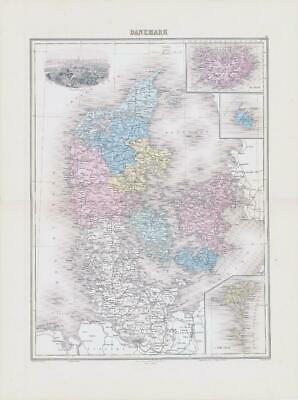
1892 Large Colour Antique Map of DANEMARK Denmark Copenhague Copenhagen (NAI/40)
Librería: Antique Paper Company, ASHFORD, KENT, Reino Unido
Calificación del vendedor: 2 de 5 estrellas
EUR 41,82
Envío por EUR 6,96
Se envía de Reino Unido a Estados Unidos de AmericaCantidad disponible: 1 disponibles
Ańadir al carritoListing Template 2018 Home About Us View Feedback Contact Us 1892 Large Colour Antique Map of DANEMARK Denmark Copenhague Copenhagen (NAI/40)Click image to enlargeDescription1892Large original colourmap titled:DANEMARKA fine colour map of DENMARK. With avignetteviewof COPENHAGUE (COPENHAGEN).ProvenanceTaken from 'NOUVEL ATLAS ILLUSTRE Geographie Universelle' published by Direction Et Administration, 11, Rue du Moulin-Vert, Paris, 1892Excellent conditionwith central fold as issued.Size of mapapprox 52cm x 39cm (20.5in x 15.5in) including margins. View Our Categories Decorative Prints World Wide Maps Scotland Maps Architecture Design England Maps Royalty About UsWe specialise in selling all items that can be considered to be Antique Paper. * PRINTS * MAPS * HISTORICAL DOCUMENTS * POSTAL HISTORY * BOOKS * POSTERS * STAMPS * POSTCARDS * EPHEMERA And anything else that is considered Antique and made of Paper. ALL OF OUR ITEMS ARE ORIGINAL ANTIQUES - NOT MODERN COPIES. We are also very keen buyers of anything similar and especially after better collections, original archives, whole libraries and better single items and have ÂŁ250,000 in cash funds at anyone time to buy the right items. Contact UsIf you have any questions then please do not hesitate to contact us through the eBay messaging system. Feedback We will always help you to have a 100% positive happy buying experience. Contact us if you are unhappy about any aspect of your purchase from us. We only want five star feedback from you so buy with confidence.
-

1892 Large Colour Antique Map ESPAGNE ET PORTUGAL Spain and Portugal (NAI/29)
Librería: Antique Paper Company, ASHFORD, KENT, Reino Unido
Calificación del vendedor: 2 de 5 estrellas
EUR 41,82
Envío por EUR 6,96
Se envía de Reino Unido a Estados Unidos de AmericaCantidad disponible: 1 disponibles
Ańadir al carritoListing Template 2018 Home About Us View Feedback Contact Us 1892 Large Colour Antique Map ESPAGNE ET PORTUGAL Spain and Portugal (NAI/29)Click image to enlargeDescription1892Large original colourmap titled:ESPAGNE ET PORTUGALA fine colour map of SPAIN AND PORTUGAL. With vignette viewsofLISBONNE (LISBON) AND MADRID.ProvenanceTaken from 'NOUVEL ATLAS ILLUSTRE Geographie Universelle' published by Direction Et Administration, 11, Rue du Moulin-Vert, Paris, 1892Excellent conditionwith central fold as issued.Size of mapapprox 52cm x 39cm (20.5in x 15.5in) including margins. View Our Categories Decorative Prints World Wide Maps Scotland Maps Architecture Design England Maps Royalty About UsWe specialise in selling all items that can be considered to be Antique Paper. * PRINTS * MAPS * HISTORICAL DOCUMENTS * POSTAL HISTORY * BOOKS * POSTERS * STAMPS * POSTCARDS * EPHEMERA And anything else that is considered Antique and made of Paper. ALL OF OUR ITEMS ARE ORIGINAL ANTIQUES - NOT MODERN COPIES. We are also very keen buyers of anything similar and especially after better collections, original archives, whole libraries and better single items and have ÂŁ250,000 in cash funds at anyone time to buy the right items. Contact UsIf you have any questions then please do not hesitate to contact us through the eBay messaging system. Feedback We will always help you to have a 100% positive happy buying experience. Contact us if you are unhappy about any aspect of your purchase from us. We only want five star feedback from you so buy with confidence.
-

1892 Large Colour Antique Map of AFRIQUE PHYSIQUE Physical Africa (NAI/50)
Librería: Antique Paper Company, ASHFORD, KENT, Reino Unido
Calificación del vendedor: 2 de 5 estrellas
EUR 45,40
Envío por EUR 6,96
Se envía de Reino Unido a Estados Unidos de AmericaCantidad disponible: 1 disponibles
Ańadir al carritoListing Template 2018 Home About Us View Feedback Contact Us 1892 Large Colour Antique Map of AFRIQUE PHYSIQUE Physical Africa (NAI/50)Click image to enlargeDescription1892Large original colourmap titled:AFRIQUE PHYSIQUEA fine colour map of PHYSICAL AFRICA.With a vignetteview of CHAMP DE DIAMANTS,PRand#201;S DE BLOEMFOTEIN.ProvenanceTaken from 'NOUVEL ATLAS ILLUSTRE Geographie Universelle' published by Direction Et Administration, 11, Rue du Moulin-Vert, Paris, 1892Excellent conditionwith central fold as issued.Size of mapapprox 52cm x 39cm (20.5in x 15.5in) including margins. View Our Categories Decorative Prints World Wide Maps Scotland Maps Architecture Design England Maps Royalty About UsWe specialise in selling all items that can be considered to be Antique Paper. * PRINTS * MAPS * HISTORICAL DOCUMENTS * POSTAL HISTORY * BOOKS * POSTERS * STAMPS * POSTCARDS * EPHEMERA And anything else that is considered Antique and made of Paper. ALL OF OUR ITEMS ARE ORIGINAL ANTIQUES - NOT MODERN COPIES. We are also very keen buyers of anything similar and especially after better collections, original archives, whole libraries and better single items and have ÂŁ250,000 in cash funds at anyone time to buy the right items. Contact UsIf you have any questions then please do not hesitate to contact us through the eBay messaging system. Feedback We will always help you to have a 100% positive happy buying experience. Contact us if you are unhappy about any aspect of your purchase from us. We only want five star feedback from you so buy with confidence.
-

1892 Large Colour Antique Map FRANCE HYPSOMĂTRIQUE Hypsometric France (NAI/18)
Librería: Antique Paper Company, ASHFORD, KENT, Reino Unido
Calificación del vendedor: 2 de 5 estrellas
EUR 52,57
Envío por EUR 6,96
Se envía de Reino Unido a Estados Unidos de AmericaCantidad disponible: 1 disponibles
Ańadir al carritoListing Template 2018 Home About Us View Feedback Contact Us 1892 Large Colour Antique Map FRANCE HYPSOMĂTRIQUE Hypsometric France (NAI/18)Click image to enlargeDescription1892Large original colourmap titled:FRANCE HYPSOMand#201;TRIQUEA fine colour HYPSOMETRIC MAP OF FRANCE. With a vignette view ofMONT BLANC.ProvenanceTaken from 'NOUVEL ATLAS ILLUSTRE Geographie Universelle' published by Direction Et Administration, 11, Rue du Moulin-Vert, Paris, 1892Excellent conditionwith central fold as issued.Size of mapapprox 52cm x 39cm (20.5in x 15.5in) including margins. View Our Categories Decorative Prints World Wide Maps Scotland Maps Architecture Design England Maps Royalty About UsWe specialise in selling all items that can be considered to be Antique Paper. * PRINTS * MAPS * HISTORICAL DOCUMENTS * POSTAL HISTORY * BOOKS * POSTERS * STAMPS * POSTCARDS * EPHEMERA And anything else that is considered Antique and made of Paper. ALL OF OUR ITEMS ARE ORIGINAL ANTIQUES - NOT MODERN COPIES. We are also very keen buyers of anything similar and especially after better collections, original archives, whole libraries and better single items and have ÂŁ250,000 in cash funds at anyone time to buy the right items. Contact UsIf you have any questions then please do not hesitate to contact us through the eBay messaging system. Feedback We will always help you to have a 100% positive happy buying experience. Contact us if you are unhappy about any aspect of your purchase from us. We only want five star feedback from you so buy with confidence.
-

1892 Large Colour Antique Map of ASIE Asia Vignette View of Bènarés (NAI/44)
Librería: Antique Paper Company, ASHFORD, KENT, Reino Unido
Calificación del vendedor: 2 de 5 estrellas
EUR 62,73
Envío por EUR 6,96
Se envía de Reino Unido a Estados Unidos de AmericaCantidad disponible: 1 disponibles
Ańadir al carritoListing Template 2018 Home About Us View Feedback Contact Us 1892 Large Colour Antique Map of ASIE Asia Vignette View of BènarĂ©s (NAI/44)Click image to enlargeDescription1892Large original colourmap titled:ASIEA fine colour map of ASIA. With avignetteviewof Band#200;NARand#201;S.ProvenanceTaken from 'NOUVEL ATLAS ILLUSTRE Geographie Universelle' published by Direction Et Administration, 11, Rue du Moulin-Vert, Paris, 1892Excellent conditionwith central fold as issued.Size of mapapprox 52cm x 39cm (20.5in x 15.5in) including margins. View Our Categories Decorative Prints World Wide Maps Scotland Maps Architecture Design England Maps Royalty About UsWe specialise in selling all items that can be considered to be Antique Paper. * PRINTS * MAPS * HISTORICAL DOCUMENTS * POSTAL HISTORY * BOOKS * POSTERS * STAMPS * POSTCARDS * EPHEMERA And anything else that is considered Antique and made of Paper. ALL OF OUR ITEMS ARE ORIGINAL ANTIQUES - NOT MODERN COPIES. We are also very keen buyers of anything similar and especially after better collections, original archives, whole libraries and better single items and have ÂŁ250,000 in cash funds at anyone time to buy the right items. Contact UsIf you have any questions then please do not hesitate to contact us through the eBay messaging system. Feedback We will always help you to have a 100% positive happy buying experience. Contact us if you are unhappy about any aspect of your purchase from us. We only want five star feedback from you so buy with confidence.
-

1892 Large Colour Antique Map of ĂTATS-UNIS United States of America (NAI/58)
Librería: Antique Paper Company, ASHFORD, KENT, Reino Unido
Calificación del vendedor: 2 de 5 estrellas
EUR 62,73
Envío por EUR 6,96
Se envía de Reino Unido a Estados Unidos de AmericaCantidad disponible: 1 disponibles
Ańadir al carritoListing Template 2018 Home About Us View Feedback Contact Us 1892 Large Colour Antique Map of ĂTATS-UNIS United States of America (NAI/58)Click image to enlargeDescription1892Large original colourmap titled:and#201;TATS-UNISA fine colour map of the UNITED STATES OF AMERICA.With a vignetteview of WASHINGTON.ProvenanceTaken from 'NOUVEL ATLAS ILLUSTRE Geographie Universelle' published by Direction Et Administration, 11, Rue du Moulin-Vert, Paris, 1892Excellent conditionwith central fold as issued.Size of mapapprox 52cm x 39cm (20.5in x 15.5in) including margins. View Our Categories Decorative Prints World Wide Maps Scotland Maps Architecture Design England Maps Royalty About UsWe specialise in selling all items that can be considered to be Antique Paper. * PRINTS * MAPS * HISTORICAL DOCUMENTS * POSTAL HISTORY * BOOKS * POSTERS * STAMPS * POSTCARDS * EPHEMERA And anything else that is considered Antique and made of Paper. ALL OF OUR ITEMS ARE ORIGINAL ANTIQUES - NOT MODERN COPIES. We are also very keen buyers of anything similar and especially after better collections, original archives, whole libraries and better single items and have ÂŁ250,000 in cash funds at anyone time to buy the right items. Contact UsIf you have any questions then please do not hesitate to contact us through the eBay messaging system. Feedback We will always help you to have a 100% positive happy buying experience. Contact us if you are unhappy about any aspect of your purchase from us. We only want five star feedback from you so buy with confidence.
-

1892 Large Colour Antique Map of ASIE Asia Vignette View of Bènarés (NAI/44)
Librería: Antique Paper Company, ASHFORD, KENT, Reino Unido
Calificación del vendedor: 2 de 5 estrellas
EUR 62,73
Envío por EUR 6,96
Se envía de Reino Unido a Estados Unidos de AmericaCantidad disponible: 1 disponibles
Ańadir al carritoListing Template 2018 Home About Us View Feedback Contact Us 1892 Large Colour Antique Map of ASIE Asia Vignette View of BènarĂ©s (NAI/44)Click image to enlargeDescription1892Large original colourmap titled:ASIEA fine colour map of ASIA. With avignetteviewof Band#200;NARand#201;S.ProvenanceTaken from 'NOUVEL ATLAS ILLUSTRE Geographie Universelle' published by Direction Et Administration, 11, Rue du Moulin-Vert, Paris, 1892Excellent conditionwith central fold as issued.Size of mapapprox 52cm x 39cm (20.5in x 15.5in) including margins. View Our Categories Decorative Prints World Wide Maps Scotland Maps Architecture Design England Maps Royalty About UsWe specialise in selling all items that can be considered to be Antique Paper. * PRINTS * MAPS * HISTORICAL DOCUMENTS * POSTAL HISTORY * BOOKS * POSTERS * STAMPS * POSTCARDS * EPHEMERA And anything else that is considered Antique and made of Paper. ALL OF OUR ITEMS ARE ORIGINAL ANTIQUES - NOT MODERN COPIES. We are also very keen buyers of anything similar and especially after better collections, original archives, whole libraries and better single items and have ÂŁ250,000 in cash funds at anyone time to buy the right items. Contact UsIf you have any questions then please do not hesitate to contact us through the eBay messaging system. Feedback We will always help you to have a 100% positive happy buying experience. Contact us if you are unhappy about any aspect of your purchase from us. We only want five star feedback from you so buy with confidence.
-

1892 Large Colour Antique Map of IRLANDE Ireland Vignette View Dublin (NAI/28)
Librería: Antique Paper Company, ASHFORD, KENT, Reino Unido
Calificación del vendedor: 2 de 5 estrellas
EUR 75,27
Envío por EUR 6,96
Se envía de Reino Unido a Estados Unidos de AmericaCantidad disponible: 1 disponibles
Ańadir al carritoListing Template 2018 Home About Us View Feedback Contact Us 1892 Large Colour Antique Map of IRLANDE Ireland Vignette View Dublin (NAI/28)Click image to enlargeDescription1892Large original colourmap titled:IRLANDEA fine colour map of IRELAND. With a vignette view ofDUBLIN.ProvenanceTaken from 'NOUVEL ATLAS ILLUSTRE Geographie Universelle' published by Direction Et Administration, 11, Rue du Moulin-Vert, Paris, 1892Excellent conditionwith central fold as issued.Size of mapapprox 52cm x 39cm (20.5in x 15.5in) including margins. View Our Categories Decorative Prints World Wide Maps Scotland Maps Architecture Design England Maps Royalty About UsWe specialise in selling all items that can be considered to be Antique Paper. * PRINTS * MAPS * HISTORICAL DOCUMENTS * POSTAL HISTORY * BOOKS * POSTERS * STAMPS * POSTCARDS * EPHEMERA And anything else that is considered Antique and made of Paper. ALL OF OUR ITEMS ARE ORIGINAL ANTIQUES - NOT MODERN COPIES. We are also very keen buyers of anything similar and especially after better collections, original archives, whole libraries and better single items and have ÂŁ250,000 in cash funds at anyone time to buy the right items. Contact UsIf you have any questions then please do not hesitate to contact us through the eBay messaging system. Feedback We will always help you to have a 100% positive happy buying experience. Contact us if you are unhappy about any aspect of your purchase from us. We only want five star feedback from you so buy with confidence.
-

1892 Large Colour Antique Map of CHINE ET CORĂE China and Korea Peking (NAI/46)
Librería: Antique Paper Company, ASHFORD, KENT, Reino Unido
Calificación del vendedor: 2 de 5 estrellas
EUR 89,61
Envío por EUR 6,96
Se envía de Reino Unido a Estados Unidos de AmericaCantidad disponible: 1 disponibles
Ańadir al carritoListing Template 2018 Home About Us View Feedback Contact Us 1892 Large Colour Antique Map of CHINE ET CORĂE China and Korea Peking (NAI/46)Click image to enlargeDescription1892Large original colourmap titled:CHINE ET CORand#201;EA fine colour map of CHINA AND KOREA. With vignetteviewsof PEKING AND TOKIO (TOKYO).ProvenanceTaken from 'NOUVEL ATLAS ILLUSTRE Geographie Universelle' published by Direction Et Administration, 11, Rue du Moulin-Vert, Paris, 1892Excellent conditionwith central fold as issued.Size of mapapprox 52cm x 39cm (20.5in x 15.5in) including margins. View Our Categories Decorative Prints World Wide Maps Scotland Maps Architecture Design England Maps Royalty About UsWe specialise in selling all items that can be considered to be Antique Paper. * PRINTS * MAPS * HISTORICAL DOCUMENTS * POSTAL HISTORY * BOOKS * POSTERS * STAMPS * POSTCARDS * EPHEMERA And anything else that is considered Antique and made of Paper. ALL OF OUR ITEMS ARE ORIGINAL ANTIQUES - NOT MODERN COPIES. We are also very keen buyers of anything similar and especially after better collections, original archives, whole libraries and better single items and have ÂŁ250,000 in cash funds at anyone time to buy the right items. Contact UsIf you have any questions then please do not hesitate to contact us through the eBay messaging system. Feedback We will always help you to have a 100% positive happy buying experience. Contact us if you are unhappy about any aspect of your purchase from us. We only want five star feedback from you so buy with confidence.
