
Importe total (1 artículo artículos):
Destino del pedido:

1850 original antique map east (4 resultados)
Comentarios
Ir a los resultados principales
Filtros de búsqueda
Tipo de artículo
- Todos los tipos de productos
- Libros (2)
- Revistas y publicaciones (No hay ningún otro resultado que coincida con este filtro.)
- Cómics (No hay ningún otro resultado que coincida con este filtro.)
- Partituras (No hay ningún otro resultado que coincida con este filtro.)
- Arte, grabados y pósters (No hay ningún otro resultado que coincida con este filtro.)
- Fotografías (No hay ningún otro resultado que coincida con este filtro.)
- Mapas (2)
- Manuscritos y coleccionismo de papel (No hay ningún otro resultado que coincida con este filtro.)
Condición Más información
- Nuevo (No hay ningún otro resultado que coincida con este filtro.)
- Como nuevo, Excelente o Muy bueno (No hay ningún otro resultado que coincida con este filtro.)
- Bueno o Aceptable (No hay ningún otro resultado que coincida con este filtro.)
- Regular o Pobre (No hay ningún otro resultado que coincida con este filtro.)
- Tal como se indica (4)
Encuadernación
- Todas
- Tapa dura (No hay ningún otro resultado que coincida con este filtro.)
- Tapa blanda (No hay ningún otro resultado que coincida con este filtro.)
Más atributos
- Primera edición (No hay ningún otro resultado que coincida con este filtro.)
- Firmado (No hay ningún otro resultado que coincida con este filtro.)
- Sobrecubierta (No hay ningún otro resultado que coincida con este filtro.)
- Con imágenes (4)
- No impresión bajo demanda (4)
Idioma (1)
Precio
- Cualquier precio
- Menos de EUR 20 (No hay ningún otro resultado que coincida con este filtro.)
- EUR 20 a EUR 45 (No hay ningún otro resultado que coincida con este filtro.)
- Más de EUR 45
Gastos de envío gratis
- Envío gratis a Espańa (No hay ningún otro resultado que coincida con este filtro.)
Ubicación del vendedor
Valoración de los vendedores
-

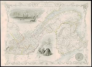
1850 Original Antique Map EAST CANADA AND NEW BRUNSWICK by Tallis (TM4-7)
Librería: Antique Paper Company, ASHFORD, KENT, Reino Unido
Calificación del vendedor: 2 de 5 estrellas

Mapa
EUR 53,24
Convertir monedaEUR 6,89 gastos de envío desde Reino Unido a EspańaCantidad disponible: 1 disponibles
Ańadir al carrito1850 EAST CANADA AND NEW BRUNSWICK Original antique map by John Tallis with vignette views of QUEBEC and NORTH AMERICAN INDIANS. Condition is generally fine with central fold as issued and original outline hand colour. Size approx 35.5cm x 27cm including margins.
-
1850 Original Antique Map of "EAST CANADA & NEW BRUNSWICK" by Tallis (58dw)
Librería: Antique Paper Company, ASHFORD, KENT, Reino Unido
Calificación del vendedor: 2 de 5 estrellas
EUR 56,20
Convertir monedaEUR 6,89 gastos de envío desde Reino Unido a EspańaCantidad disponible: 1 disponibles
Ańadir al carritoEAST CANADA AND NEW BRUNSWICK Drawn & engraved by John Rapkin for The Illustrated Atlas and Modern History of the World by Martin Montgomery. An attractive and decorative map of EAST CANADA AND NEW BRUNSWICK showing parts of Montreal, Sherbrooke, Northumberland, Charlotte etc with vignette engravings of QUEBEC & NORTH AMERICAN INDIANS. Original outline hand colouring. An excellent exle of the preferred Montgomery Martin edition. Generally fine condition - unfolded. Approx 360mm x 280mm and printed on heavy grade paper. Perfect for mounting & framing. John Tallis is considered to be one of the most renowned cartographers and publisher of the C19th . His maps are considered to be the last of the lavishly decorated and ornamental maps, works of art as much of geography. He was born in Stourbridge in Worcestershire in about 1818 and it is possible he stayed working in the Midlands working as a publisher in Birmingham, until he moved to London in the early 1840âs.John then set up the first of his publishing businesses, in Cripplegate, with Frederick Tallis, who was quite possibly his brother. This business lasted from 1842 to 1849 when it was dissolved. By 1846 the business had moved to Smithfield.From 1851 â" 54, John set up another business, operating as John Tallis and Company and it was during this period that he produced the Illustrated World Atlas, produced for the 1851 Great Exhibition The intriguing thing is, that at some point, John Tallis made the acquaintance of an engraver called John Rapkin who was an inspiration to Tallis. His stunning illustrations enabled the maps they produced to be beautiful illumanitive works of art. John Rapkinâs work inspired John Tallis and they used travelogues extensively to guide Joh Rapkin as he produced vignettes and ornamental engravings to embelish the Tallis maps. All our items are original Antiques and as described. We provide a No Quibble Money Back Guarantee.
-

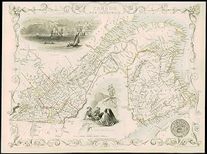
1850 Original Antique Map EAST CANADA and NEW BRUNSWICK by Tallis (TM4-13)
Librería: Antique Paper Company, ASHFORD, KENT, Reino Unido
Calificación del vendedor: 2 de 5 estrellas
Mapa
EUR 94,64
Convertir monedaEUR 6,89 gastos de envío desde Reino Unido a EspańaCantidad disponible: 1 disponibles
Ańadir al carrito1850 EAST CANADA AND NEW BRUNSWICK Original antique map by John Tallis with vignette views of QUEBEC - NORTH AMERICAN INDIANS. Condition is generally fine with central fold as issued and FULL HAND COLOUR. Size approx 35.5cm x 27cm including margins.
-
1850 Original Antique Map of "EAST CANADA & NEW BRUNSWICK" by Tallis (60dw)
Librería: Antique Paper Company, ASHFORD, KENT, Reino Unido
Calificación del vendedor: 2 de 5 estrellas
EUR 62,11
Convertir monedaEUR 6,89 gastos de envío desde Reino Unido a EspańaCantidad disponible: 1 disponibles
Ańadir al carritoEAST CANADA AND NEW BRUNSWICK Drawn & engraved by John Rapkin for The Illustrated Atlas and Modern History of the World by Martin Montgomery. An attractive and decorative map of EAST CANADA AND NEW BRUNSWICK showing parts of Montreal, Sherbrooke, Northumberland, Charlotte etc with vignette engravings of QUEBEC & NORTH AMERICAN INDIANS. Original outline hand colouring. An excellent exle of the preferred Montgomery Martin edition. Generally fine condition - unfolded. Approx 360mm x 280mm and printed on heavy grade paper. Perfect for mounting & framing. John Tallis is considered to be one of the most renowned cartographers and publisher of the C19th . His maps are considered to be the last of the lavishly decorated and ornamental maps, works of art as much of geography. He was born in Stourbridge in Worcestershire in about 1818 and it is possible he stayed working in the Midlands working as a publisher in Birmingham, until he moved to London in the early 1840âs.John then set up the first of his publishing businesses, in Cripplegate, with Frederick Tallis, who was quite possibly his brother. This business lasted from 1842 to 1849 when it was dissolved. By 1846 the business had moved to Smithfield.From 1851 â" 54, John set up another business, operating as John Tallis and Company and it was during this period that he produced the Illustrated World Atlas, produced for the 1851 Great Exhibition The intriguing thing is, that at some point, John Tallis made the acquaintance of an engraver called John Rapkin who was an inspiration to Tallis. His stunning illustrations enabled the maps they produced to be beautiful illumanitive works of art. John Rapkinâs work inspired John Tallis and they used travelogues extensively to guide Joh Rapkin as he produced vignettes and ornamental engravings to embelish the Tallis maps. All our items are original Antiques and as described. We provide a No Quibble Money Back Guarantee.