
Importe total (1 artículo artículos):
Destino del pedido:

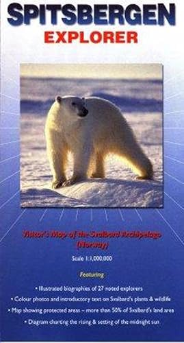
9780953861811 - Spitsbergen Explorer: Visitor's Map of the Svalbard Archipelago (Norway) (Ocean Explorer Maps) de Sitwell, Nigel (18 resultados)
Ir a los resultados principales
Filtros de búsqueda
Tipo de artículo
- Todos los tipos de productos
- Libros (15)
- Revistas y publicaciones (No hay ningún otro resultado que coincida con este filtro.)
- Cómics (No hay ningún otro resultado que coincida con este filtro.)
- Partituras (No hay ningún otro resultado que coincida con este filtro.)
- Arte, grabados y pósters (No hay ningún otro resultado que coincida con este filtro.)
- Fotografías (No hay ningún otro resultado que coincida con este filtro.)
- Mapas (3)
- Manuscritos y coleccionismo de papel (No hay ningún otro resultado que coincida con este filtro.)
Condición Más información
- Nuevo (17)
- Como nuevo, Excelente o Muy bueno (1)
- Bueno o Aceptable (No hay ningún otro resultado que coincida con este filtro.)
- Regular o Pobre (No hay ningún otro resultado que coincida con este filtro.)
- Tal como se indica (No hay ningún otro resultado que coincida con este filtro.)
Encuadernación
- Todas
- Tapa dura (No hay ningún otro resultado que coincida con este filtro.)
- Tapa blanda (No hay ningún otro resultado que coincida con este filtro.)
Más atributos
- Primera edición (No hay ningún otro resultado que coincida con este filtro.)
- Firmado (No hay ningún otro resultado que coincida con este filtro.)
- Sobrecubierta (No hay ningún otro resultado que coincida con este filtro.)
- Con imágenes (8)
- No impresión bajo demanda (18)
Idioma (1)
Precio
- Cualquier precio
- Menos de EUR 20
- EUR 20 a EUR 45
- Más de EUR 45 (No hay ningún otro resultado que coincida con este filtro.)
Gastos de envío gratis
Ubicación del vendedor
Valoración de los vendedores
-
Spitsbergen Explorer (Folded)
Idioma: Inglés
Publicado por Ocean Explorer Maps, Chichester, 2001
ISBN 10: 0953861813 ISBN 13: 9780953861811
Librería: Grand Eagle Retail, Bensenville, IL, Estados Unidos de America
Calificación del vendedor: 5 de 5 estrellas

EUR 16,69
Gastos de envío gratis
Se envía dentro de Estados Unidos de AmericaCantidad disponible: 1 disponibles
Ańadir al carritoFolded. Condición: new. Folded. This map is designed to appeal to passengers on cruises that visit Svalbard, but it should also be of interest to those who explore the archipelago in other ways. It includes an explanation of why most of the world calls it Spitsbergen, but Norwegians use the name Svalbard. Special features include illustrated biographies of explorers and other historic figures; notes on the history and unique political status of this land far to the north of the Arctic Circle; locations of Svalbard's national parks and nature reserves (representing more than 50 per cent of the land area); and colour photographs and text on the plants and animal life. Though twice the size of Belgium, 60 per cent of Svalbard is covered by snow and glaciers. Because this map primarily addresses the needs of visitors who explore the area on ships, the emphasis is on popular landing places and geographical features that can be seen from the sea or which are near the shore. With this focus, land-based travellers will find little or no information here about shore-side restaurants, hotels and other lodging places, or highways, railroads and airports. Covers the Arctic archipelago (named Spitsbergen when discovered by the Dutch in 1596, but now commonly referred to as Svalbard). This title features a map of the archipelago, with annotations. It includes biographical summaries of 27 explorers as well as descriptions and colour photographs of the common plants, invertebrates, birds and mammals. Shipping may be from multiple locations in the US or from the UK, depending on stock availability.
-

Spitsbergen Explorer
Librería: PBShop.store UK, Fairford, GLOS, Reino Unido
Calificación del vendedor: 5 de 5 estrellas
EUR 13,60
Envío por EUR 3,81
Se envía de Reino Unido a Estados Unidos de AmericaCantidad disponible: 3 disponibles
Ańadir al carritoUNK. Condición: New. New Book. Shipped from UK. Established seller since 2000.
-
Spitsbergen Explorer
Librería: Majestic Books, Hounslow, Reino Unido
Calificación del vendedor: 4 de 5 estrellas

EUR 13,68
Envío por EUR 7,53
Se envía de Reino Unido a Estados Unidos de AmericaCantidad disponible: 3 disponibles
Ańadir al carritoCondición: New.
-
Spitsbergen Explorer
Librería: Revaluation Books, Exeter, Reino Unido
Calificación del vendedor: 5 de 5 estrellas
Mapa
EUR 10,62
Envío por EUR 11,58
Se envía de Reino Unido a Estados Unidos de AmericaCantidad disponible: 2 disponibles
Ańadir al carritoMap. Condición: Brand New. 1 pages. 8.98x4.57x0.08 inches. In Stock.
-
Spitsbergen Explorer
Librería: Books Puddle, New York, NY, Estados Unidos de America
Calificación del vendedor: 4 de 5 estrellas
EUR 20,38
Envío por EUR 3,46
Se envía dentro de Estados Unidos de AmericaCantidad disponible: 3 disponibles
Ańadir al carritoCondición: New.
-
Spitzbergen Explorer
Librería: Kennys Bookshop and Art Galleries Ltd., Galway, GY, Irlanda
Calificación del vendedor: 5 de 5 estrellas
EUR 15,24
Envío por EUR 10,50
Se envía de Irlanda a Estados Unidos de AmericaCantidad disponible: 4 disponibles
Ańadir al carritoCondición: New. 2010. Map. Covers the Arctic archipelago (named Spitsbergen when discovered by the Dutch in 1596, but now commonly referred to as Svalbard). This title features a map of the archipelago, with annotations. It includes biographical summaries of 27 explorers as well as descriptions and colour photographs of the common plants, invertebrates, birds and mammals. Editor(s): Sitwell, Nigel; Riffenburgh, Beau; Cruwys, Liz; Carlsson, Olle. Series: Ocean Explorer Maps. Num Pages: Col & B/w photos. BIC Classification: 1MTN; WTRM. Category: (G) General (US: Trade). Dimension: 222 x 102 x 2. Weight in Grams: 40. . . . . .
-
Spitsbergen Explorer
Librería: Biblios, Frankfurt am main, HESSE, Alemania
Calificación del vendedor: 4 de 5 estrellas
EUR 16,16
Envío por EUR 9,95
Se envía de Alemania a Estados Unidos de AmericaCantidad disponible: 3 disponibles
Ańadir al carritoCondición: New.
-
Spitsbergen Explorer Map by Ocean Explorer Maps
Librería: Ria Christie Collections, Uxbridge, Reino Unido
Calificación del vendedor: 5 de 5 estrellas
EUR 13,05
Envío por EUR 13,87
Se envía de Reino Unido a Estados Unidos de AmericaCantidad disponible: 3 disponibles
Ańadir al carritoCondición: New. In.
-
Spitzbergen Explorer
Librería: Kennys Bookstore, Olney, MD, Estados Unidos de America
Calificación del vendedor: 5 de 5 estrellas
EUR 18,00
Envío por EUR 9,11
Se envía dentro de Estados Unidos de AmericaCantidad disponible: 4 disponibles
Ańadir al carritoCondición: New. 2010. Map. Covers the Arctic archipelago (named Spitsbergen when discovered by the Dutch in 1596, but now commonly referred to as Svalbard). This title features a map of the archipelago, with annotations. It includes biographical summaries of 27 explorers as well as descriptions and colour photographs of the common plants, invertebrates, birds and mammals. Editor(s): Sitwell, Nigel; Riffenburgh, Beau; Cruwys, Liz; Carlsson, Olle. Series: Ocean Explorer Maps. Num Pages: Col & B/w photos. BIC Classification: 1MTN; WTRM. Category: (G) General (US: Trade). Dimension: 222 x 102 x 2. Weight in Grams: 40. . . . . . Books ship from the US and Ireland.
-
Spitsbergen Explorer: Visitor's Map of the Svalbard Archipelago (Norway)
Librería: THE SAINT BOOKSTORE, Southport, Reino Unido
Calificación del vendedor: 5 de 5 estrellas
EUR 14,86
Envío por EUR 13,60
Se envía de Reino Unido a Estados Unidos de AmericaCantidad disponible: 6 disponibles
Ańadir al carritoSheet map, folded. Condición: New. New copy - Usually dispatched within 3 working days.
-

Spitsbergen Explorer : Visitor's Map of the Svalbard Archipelago (Norway)
Librería: GreatBookPricesUK, Woodford Green, Reino Unido
Calificación del vendedor: 5 de 5 estrellas
EUR 13,04
Envío por EUR 17,37
Se envía de Reino Unido a Estados Unidos de AmericaCantidad disponible: 5 disponibles
Ańadir al carritoCondición: New.
-

Spitsbergen Explorer : Visitor's Map of the Svalbard Archipelago (Norway)
Librería: GreatBookPricesUK, Woodford Green, Reino Unido
Calificación del vendedor: 5 de 5 estrellas
EUR 14,55
Envío por EUR 17,37
Se envía de Reino Unido a Estados Unidos de AmericaCantidad disponible: 5 disponibles
Ańadir al carritoCondición: As New. Unread book in perfect condition.
-

Spitsbergen Explorer (Folded)
Idioma: Inglés
Publicado por Ocean Explorer Maps, Chichester, 2001
ISBN 10: 0953861813 ISBN 13: 9780953861811
Librería: CitiRetail, Stevenage, Reino Unido
Calificación del vendedor: 5 de 5 estrellas
EUR 14,30
Envío por EUR 42,84
Se envía de Reino Unido a Estados Unidos de AmericaCantidad disponible: 1 disponibles
Ańadir al carritoFolded. Condición: new. Folded. This map is designed to appeal to passengers on cruises that visit Svalbard, but it should also be of interest to those who explore the archipelago in other ways. It includes an explanation of why most of the world calls it Spitsbergen, but Norwegians use the name Svalbard. Special features include illustrated biographies of explorers and other historic figures; notes on the history and unique political status of this land far to the north of the Arctic Circle; locations of Svalbard's national parks and nature reserves (representing more than 50 per cent of the land area); and colour photographs and text on the plants and animal life. Though twice the size of Belgium, 60 per cent of Svalbard is covered by snow and glaciers. Because this map primarily addresses the needs of visitors who explore the area on ships, the emphasis is on popular landing places and geographical features that can be seen from the sea or which are near the shore. With this focus, land-based travellers will find little or no information here about shore-side restaurants, hotels and other lodging places, or highways, railroads and airports. Covers the Arctic archipelago (named Spitsbergen when discovered by the Dutch in 1596, but now commonly referred to as Svalbard). This title features a map of the archipelago, with annotations. It includes biographical summaries of 27 explorers as well as descriptions and colour photographs of the common plants, invertebrates, birds and mammals. Shipping may be from our UK warehouse or from our Australian or US warehouses, depending on stock availability.
-

Spitsbergen Explorer (Folded)
Idioma: Inglés
Publicado por Ocean Explorer Maps, Chichester, 2001
ISBN 10: 0953861813 ISBN 13: 9780953861811
Librería: AussieBookSeller, Truganina, VIC, Australia
Calificación del vendedor: 5 de 5 estrellas
EUR 25,60
Envío por EUR 32,11
Se envía de Australia a Estados Unidos de AmericaCantidad disponible: 1 disponibles
Ańadir al carritoFolded. Condición: new. Folded. This map is designed to appeal to passengers on cruises that visit Svalbard, but it should also be of interest to those who explore the archipelago in other ways. It includes an explanation of why most of the world calls it Spitsbergen, but Norwegians use the name Svalbard. Special features include illustrated biographies of explorers and other historic figures; notes on the history and unique political status of this land far to the north of the Arctic Circle; locations of Svalbard's national parks and nature reserves (representing more than 50 per cent of the land area); and colour photographs and text on the plants and animal life. Though twice the size of Belgium, 60 per cent of Svalbard is covered by snow and glaciers. Because this map primarily addresses the needs of visitors who explore the area on ships, the emphasis is on popular landing places and geographical features that can be seen from the sea or which are near the shore. With this focus, land-based travellers will find little or no information here about shore-side restaurants, hotels and other lodging places, or highways, railroads and airports. Covers the Arctic archipelago (named Spitsbergen when discovered by the Dutch in 1596, but now commonly referred to as Svalbard). This title features a map of the archipelago, with annotations. It includes biographical summaries of 27 explorers as well as descriptions and colour photographs of the common plants, invertebrates, birds and mammals. Shipping may be from our Sydney, NSW warehouse or from our UK or US warehouse, depending on stock availability.
-
SPITSBERGEN EXPLORER
Librería: Speedyhen, Hertfordshire, Reino Unido
Calificación del vendedor: 5 de 5 estrellas
EUR 11,74
Envío por EUR 47,47
Se envía de Reino Unido a Estados Unidos de AmericaCantidad disponible: 3 disponibles
Ańadir al carritoCondición: NEW.
-

EUR 16,11
Envío por EUR 48,99
Se envía de Alemania a Estados Unidos de AmericaCantidad disponible: 3 disponibles
Ańadir al carritoCondición: New. KlappentextrnrnCovers the Arctic archipelago (named Spitsbergen when discovered by the Dutch in 1596, but now commonly referred to as Svalbard). This title features a map of the archipelago, with annotations. It includes biographical summaries o.
-

Spitsbergen Explorer : Visitor's Map of the Svalbard Archipelago (Norway)
Idioma: Inglés
Publicado por Ocean Explorer Maps Dez 2001, 2001
ISBN 10: 0953861813 ISBN 13: 9780953861811
Librería: AHA-BUCH GmbH, Einbeck, Alemania
Calificación del vendedor: 5 de 5 estrellas
Mapa
EUR 13,65
Envío por EUR 60,20
Se envía de Alemania a Estados Unidos de AmericaCantidad disponible: 2 disponibles
Ańadir al carritoKarte. Condición: Neu. Neuware - Covers the Arctic archipelago (named Spitsbergen when discovered by the Dutch in 1596, but now commonly referred to as Svalbard). This title features a map of the archipelago, with annotations. It includes biographical summaries of 27 explorers as well as descriptions and colour photographs of the common plants, invertebrates, birds and mammals.
-

Spitsbergen Explorer | Visitor's Map of the Svalbard Archipelago (Norway)
Librería: preigu, Osnabrück, Alemania
Calificación del vendedor: 5 de 5 estrellas
Mapa
EUR 16,30
Envío por EUR 70,00
Se envía de Alemania a Estados Unidos de AmericaCantidad disponible: 1 disponibles
Ańadir al carrito(Land-)Karte. Condición: Neu. Spitsbergen Explorer | Visitor's Map of the Svalbard Archipelago (Norway) | Nigel Sitwell | (Land-)Karte | Ocean Explorer Maps | Karte/Landkarte | Englisch | 2001 | Ocean Explorer Maps | EAN 9780953861811 | Verantwortliche Person für die EU: Libri GmbH, Europaallee 1, 36244 Bad Hersfeld, gpsr[at]libri[dot]de | Anbieter: preigu.