
Importe total (1 artículo artículos):
Destino del pedido:

coasting (17 resultados)
Editorial :
coasting
Refinar con la Búsqueda avanzada
Ir a los resultados principales
Filtros de búsqueda
Tipo de artículo
- Todos los tipos de productos
- Libros (16)
- Revistas y publicaciones (No hay ningún otro resultado que coincida con este filtro.)
- Cómics (No hay ningún otro resultado que coincida con este filtro.)
- Partituras (No hay ningún otro resultado que coincida con este filtro.)
- Arte, grabados y pósters (No hay ningún otro resultado que coincida con este filtro.)
- Fotografías (No hay ningún otro resultado que coincida con este filtro.)
- Mapas (1)
- Manuscritos y coleccionismo de papel (No hay ningún otro resultado que coincida con este filtro.)
Condición Más información
- Nuevo (No hay ningún otro resultado que coincida con este filtro.)
- Como nuevo, Excelente o Muy bueno (No hay ningún otro resultado que coincida con este filtro.)
- Bueno o Aceptable (8)
- Regular o Pobre (No hay ningún otro resultado que coincida con este filtro.)
- Tal como se indica (9)
Encuadernación
- Todas
- Tapa dura (No hay ningún otro resultado que coincida con este filtro.)
- Tapa blanda (8)
Más atributos
- Primera edición (No hay ningún otro resultado que coincida con este filtro.)
- Firmado (2)
- Sobrecubierta (No hay ningún otro resultado que coincida con este filtro.)
- Con imágenes (10)
- No impresión bajo demanda (17)
Idioma (2)
Gastos de envío gratis
Ubicación del vendedor
Valoración de los vendedores
-

Coasting Through Mardi Gras
Librería: Bookmonger.Ltd, HILLSIDE, NJ, Estados Unidos de America
Calificación del vendedor: 5 de 5 estrellas

EUR 1,34
Envío por EUR 3,46
Se envía dentro de Estados Unidos de AmericaCantidad disponible: 1 disponibles
Ańadir al carritoPaperback. Condición: Good. * Crease on cover*.
-
Coasting Through Mardi Gras
Librería: ThriftBooks-Dallas, Dallas, TX, Estados Unidos de America
Calificación del vendedor: 5 de 5 estrellas
EUR 5,98
Gastos de envío gratis
Se envía dentro de Estados Unidos de AmericaCantidad disponible: 1 disponibles
Ańadir al carritoPaperback. Condición: Good. No Jacket. Pages can have notes/highlighting. Spine may show signs of wear. ~ ThriftBooks: Read More, Spend Less.
-
Coasting Through Mardi Gras
Librería: ThriftBooks-Dallas, Dallas, TX, Estados Unidos de America
Calificación del vendedor: 5 de 5 estrellas
EUR 5,98
Gastos de envío gratis
Se envía dentro de Estados Unidos de AmericaCantidad disponible: 1 disponibles
Ańadir al carritoPaperback. Condición: Very Good. No Jacket. May have limited writing in cover pages. Pages are unmarked. ~ ThriftBooks: Read More, Spend Less.
-
Coasting Through Mardi Gras
Librería: ThriftBooks-Phoenix, Phoenix, AZ, Estados Unidos de America
Calificación del vendedor: 5 de 5 estrellas
EUR 10,65
Gastos de envío gratis
Se envía dentro de Estados Unidos de AmericaCantidad disponible: 1 disponibles
Ańadir al carritoPaperback. Condición: Very Good. No Jacket. May have limited writing in cover pages. Pages are unmarked. ~ ThriftBooks: Read More, Spend Less.
-

Coasating: a Guide to the Northern Gulf Coast
Idioma: Inglés
Publicado por Coasting, Point Clear, AL, 1993
ISBN 10: 0964152002 ISBN 13: 9780964152007
Librería: Sessions Book Sales, Birmingham, AL, Estados Unidos de America
Calificación del vendedor: 5 de 5 estrellas
Ejemplar firmado
EUR 11,53
Envío por EUR 3,76
Se envía dentro de Estados Unidos de AmericaCantidad disponible: 1 disponibles
Ańadir al carritoSoft Cover. Condición: Very Good. Priscilla Vilord Ilustrador. Signed by Author. Trade Paperback.
-
Coasting : A Guide to the Northern Gulf Coast
Librería: Cheryl's Books, Vinemont, AL, Estados Unidos de America
Calificación del vendedor: 5 de 5 estrellas
EUR 11,11
Envío por EUR 5,57
Se envía dentro de Estados Unidos de AmericaCantidad disponible: 1 disponibles
Ańadir al carritoPaperback. Condición: Very Good. Priscilla Vilord Ilustrador. Paperback book in good condition.
-
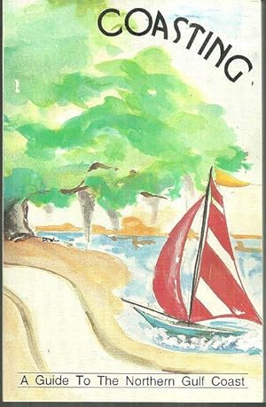
COASTING A Guide to the Northern Gulf Coast
Publicado por Coasting, Point Clear, AL, 1993
ISBN 10: 0964152002 ISBN 13: 9780964152007
Librería: Gibson's Books, New Hope, AL, Estados Unidos de America
Calificación del vendedor: 5 de 5 estrellas
EUR 10,68
Envío por EUR 6,05
Se envía dentro de Estados Unidos de AmericaCantidad disponible: 1 disponibles
Ańadir al carritoSoftcover. Very Good with no dust jacket; Edgewear; B&W Illustrations; 177 pages.
-

Coasting: An Expanded Guide to the Northern Gulf Coast
Librería: Muse Book Shop, DeLand, FL, Estados Unidos de America
Calificación del vendedor: 5 de 5 estrellas
Ejemplar firmado
EUR 44,50
Envío por EUR 8,64
Se envía dentro de Estados Unidos de AmericaCantidad disponible: 1 disponibles
Ańadir al carritoSoft cover. Condición: Very Good. signed by all 4 authors. Signed by Author(s).
-
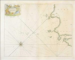
Sea Chart of Milford Haven,
Publicado por from Great Britain's Coasting Pilot, 1760
Librería: Roz Hulse, Plymouth, DEVON, Reino Unido
Calificación del vendedor: 5 de 5 estrellas
Mapa
EUR 119,32
Envío por EUR 40,54
Se envía de Reino Unido a Estados Unidos de AmericaCantidad disponible: 1 disponibles
Ańadir al carritoNo Binding. Condición: Very Good. Collins, Greenville : Chart of Milford Haven, from Great Britain's Coasting Pilot, ca.1760. Copper engraved chart. Map size approx 560mm x 440mm. Wide margins, hand coloured, good impression on heavy paper, showing the Welsh coast at Milford Haven. Compass rose, rhumb lines, scale. Cartouche with cherub, dedicated to Sir Hugh Owen. Light water stain to top margin just touching printed area, otherwise a very good, bright and attractive chart.
-
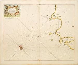
MILFORD HAVEN and the Islands adjacent
Publicado por Great Britain Coasting Pilot. 1760, 1760
Librería: Peter Harrington. ABA/ ILAB., London, Reino Unido
Miembro de asociación: ABA ILAB PBFA
Calificación del vendedor: 5 de 5 estrellas
EUR 298,29
Envío por EUR 25,49
Se envía de Reino Unido a Estados Unidos de AmericaCantidad disponible: 1 disponibles
Ańadir al carritoChart of the Pembrokeshire coast near to Milford Haven with soundings rhumb lines. Title cartouche at top left surrounded by game birds. Captain Greenvile Collins was an outstanding naval officer who became 'Hydrographer to the King' before the Coasting Pilot was published. The Coasting Pilot was the result of the first systematic survey of British coastal waters. It took eight years to complete. The charts are notable for both their accuracy and their charm Tooley, Dictionary of Maps and Map Makers p.125; Moreland & Bannister, Antique Maps p.163 Copper engraving. Expert repairs to margins and centrefold. Very good condition Later colour. Size: 56 x 44 cm. (22 x 17˝ inches).
-
![Imagen del vendedor de [Coast of Wales]. a la venta por Peter Harrington. ABA/ ILAB.](https://pictures.abebooks.com/inventory/md/md2717926600.jpg)
[Coast of Wales].
Publicado por Great Britain Coasting Pilot. 1760, 1760
Librería: Peter Harrington. ABA/ ILAB., London, Reino Unido
Miembro de asociación: ABA ILAB PBFA
Calificación del vendedor: 5 de 5 estrellas
EUR 328,12
Envío por EUR 25,49
Se envía de Reino Unido a Estados Unidos de AmericaCantidad disponible: 1 disponibles
Ańadir al carritoChart of the coast of Wales with north to the left, soundings and rhumb lines. Five silhouetees of ladnforms from the sea along top edge. Ornate dedicatory cartouche at lower left to 'Sr Cloudesley Shovell. Captain Greenvile Collins was an outstanding naval officer who became 'Hydrographer to the King' before the Coasting Pilot was published. The Coasting Pilot was the result of the first systematic survey of British coastal waters. It took eight years to complete. The charts are notable for both their accuracy and their charm Tooley, Dictionary of Maps and Map Makers p.125; Moreland & Bannister, Antique Maps p.163 Copper engraving. Expert repairs to margins. Very good condition Later colour. Size: 56 x 44 cm. (22 x 17˝ inches).
-

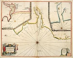
HOLYHEAD.
Publicado por Great Britain Coasting Pilot. 1760, 1760
Librería: Peter Harrington. ABA/ ILAB., London, Reino Unido
Miembro de asociación: ABA ILAB PBFA
Calificación del vendedor: 5 de 5 estrellas
EUR 357,95
Envío por EUR 25,49
Se envía de Reino Unido a Estados Unidos de AmericaCantidad disponible: 1 disponibles
Ańadir al carritoSea Chart of Holyhead, North Wales, with rhumb lines and soundings. North to the left of map. Title in ornamental cartouche at lower left. Inset views of coastline as seen from various positions at sea ('Holyhead Nb.E 4 leagues'). Captain Greenvile Collins was an outstanding naval officer who became 'Hydrographer to the King' before the Coasting Pilot was published. The Coasting Pilot was the result of the first systematic survey of British coastal waters. It took eight years to complete. The charts are notable for both their accuracy and their charm Tooley, Dictionary of Maps and Map Makers p.125; Moreland & Bannister, Antique Maps p.163 Copper engraving. Expert repairs to margins and centrefold. Very good condition Size: 56.5 x 44 cm. (22 x 17˝ inches).
-
![Imagen del vendedor de [Moray Firth] a la venta por Peter Harrington. ABA/ ILAB.](https://pictures.abebooks.com/inventory/md/md2717928177.jpg)
[Moray Firth]
Publicado por Great Britain Coasting Pilot. 1760, 1760
Librería: Peter Harrington. ABA/ ILAB., London, Reino Unido
Miembro de asociación: ABA ILAB PBFA
Calificación del vendedor: 5 de 5 estrellas
EUR 477,27
Envío por EUR 25,49
Se envía de Reino Unido a Estados Unidos de AmericaCantidad disponible: 1 disponibles
Ańadir al carritoChart of the Moray Firth in NE Scotland, with soundings and rhumblines. North to right of map.Dedicatory cartouche to Lord Viscount Torbat at top right. Captain Greenvile Collins was an outstanding naval officer who became 'Hydrographer to the King' before the Coasting Pilot was published. The Coasting Pilot was the result of the first systematic survey of British coastal waters. It took eight years to complete. The charts are notable for both their accuracy and their charm Tooley, Dictionary of Maps and Map Makers p.125; Moreland & Bannister, Antique Maps p.163 Copper engraving. Expert repairs to margins and centrefold Later colour. Size: 56 x 44 cm. (22 x 17˝ inches).
-
The Sea Coast from Fissnesse to Montrose.
Publicado por Great Britain Coasting Pilot. 1760, 1760
Librería: Peter Harrington. ABA/ ILAB., London, Reino Unido
Miembro de asociación: ABA ILAB PBFA
Calificación del vendedor: 5 de 5 estrellas
EUR 477,27
Envío por EUR 25,49
Se envía de Reino Unido a Estados Unidos de AmericaCantidad disponible: 1 disponibles
Ańadir al carritoSea chart of the coast from Crail to Aberdeen on Scotland's east coast, with inset maps of Aberdeen and Montrose harbours. Soundings and rhumb lines, ornamental cartouche at lower left with dedication to the magistrates of Aberdeen. Captain Greenvile Collins was an outstanding naval officer who became 'Hydrographer to the King' before the Coasting Pilot was published. The Coasting Pilot was the result of the first systematic survey of British coastal waters. It took eight years to complete. The charts are notable for both their accuracy and their charm Tooley, Dictionary of Maps and Map Makers p.125; Moreland & Bannister, Antique Maps p.163 Copper engraving. Expert repairs to margins and centrefold Size: 56 x 44 cm. (22 x 17˝ inches).
-
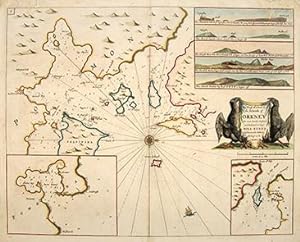
The Chief Harbours in the Islands of ORKNEY
Publicado por Great Britain Coasting Pilot. 1760, 1760
Librería: Peter Harrington. ABA/ ILAB., London, Reino Unido
Miembro de asociación: ABA ILAB PBFA
Calificación del vendedor: 5 de 5 estrellas
EUR 536,92
Envío por EUR 25,49
Se envía de Reino Unido a Estados Unidos de AmericaCantidad disponible: 1 disponibles
Ańadir al carritoSea chart of the harbours of Orkney. The main map shows the sea inlets around Kirkwall, two inset maps show Deer Sound and Stromness. Five coastal silhouettes inset at top right, title cartouche flanked by black eagles at centre right. The Great Britain Coasting Pilot was the result of the first systematic survey of British coastal waters. It took eight years to complete, and was used by the Royal Navy for navigating British waters for many years. The charts are notable for both their accuracy and their charm. Captain Greenvile Collins was an outstanding naval officer who became 'Hydrographer to the King' before the Coasting Pilot was published. Tooled, Dictionary of Maps and Map Makers p.125; Moorland & Bannister, Antique Maps p.163 Copper engraving. Expert repairs, mainly to upper margin. Very good condition. Later colour. Size: 56 x 44 cm. (22 x 17˝ inches).
-
![Imagen del vendedor de [The Irish Sea]. a la venta por Peter Harrington. ABA/ ILAB.](https://pictures.abebooks.com/inventory/md/md2717925822.jpg)
[The Irish Sea].
Publicado por Great Britain Coasting Pilot. 1760, 1760
Librería: Peter Harrington. ABA/ ILAB., London, Reino Unido
Miembro de asociación: ABA ILAB PBFA
Calificación del vendedor: 5 de 5 estrellas
EUR 596,58
Envío por EUR 25,49
Se envía de Reino Unido a Estados Unidos de AmericaCantidad disponible: 1 disponibles
Ańadir al carritoSea chart showing the coast line of England and Wales from Land's End to the Solway Firth, and the eastern coast of Ireland. Numerous soundings arounc coast, rhumblines, compass point at sea shows north to the right. Dedicatory cartouche to 'SR Richard Rooth' at right. Captain Greenvile Collins was an outstanding naval officer who became 'Hydrographer to the King' before the Coasting Pilot was published. The Coasting Pilot was the result of the first systematic survey of British coastal waters. It took eight years to complete, and was used by the British Navy for many years. The charts are notable for both their accuracy and their charm Tooley, Dictionary of Maps and Map Makers p.125; Moreland & Bannister, Antique Maps p.163 Copper engraving. Expert repairs to margin and centrefold. Very good condition Later colour. Size: 58.3 x 46 cm. (23 x 18 inches).
-
![Imagen del vendedor de [FIRTH OF FORTH]. a la venta por Peter Harrington. ABA/ ILAB.](https://pictures.abebooks.com/inventory/md/md2717927358.jpg)
[FIRTH OF FORTH].
Publicado por Great Britain Coasting Pilot. 1760, 1760
Librería: Peter Harrington. ABA/ ILAB., London, Reino Unido
Miembro de asociación: ABA ILAB PBFA
Calificación del vendedor: 5 de 5 estrellas
EUR 596,58
Envío por EUR 25,49
Se envía de Reino Unido a Estados Unidos de AmericaCantidad disponible: 1 disponibles
Ańadir al carritoSea chart of the Firth of Forth, showing the coast from Dunbar to St, Andrews. Soundings, rhumblines. Inset map of coast from St. Abb's Head to Berwick. Dedicatory cartouche at top left, decorated with spears, bannersmermaids and seamonsters, with scale in English miles below. The Great Britain Coasting Pilot was the result of the first systematic survey of British coastal waters. It took eight years to complete, and was used by the Royla Navy for navigating British waters for many years. The charts are notable for both their accuracy and their charm.Captain Greenvile Collins was an outstanding naval officer who became 'Hydrographer to the King' before the Coasting Pilot was published. Tooley, Dictionary of Maps and Map Makers p.125; Moreland & Bannister, Antique Maps p.163 Copper engraving. Expert repairs to margins. Very good condition Later colour. Size: 56.5 x 45 cm. (22 x 17˝ inches).