Importe total (1 artĒculo artĒculos):
Destino del pedido:

wit frederick (302 resultados)
Ir a los resultados principales
Filtros de b·squeda
Tipo de artĒculo
- Todos los tipos de productos
- Libros (119)
- Revistas y publicaciones (No hay ning·n otro resultado que coincida con este filtro.)
- C¾mics (No hay ning·n otro resultado que coincida con este filtro.)
- Partituras (No hay ning·n otro resultado que coincida con este filtro.)
- Arte, grabados y p¾sters (68)
- FotografĒas (No hay ning·n otro resultado que coincida con este filtro.)
- Mapas (115)
- Manuscritos y coleccionismo de papel (No hay ning·n otro resultado que coincida con este filtro.)
Condici¾n Mßs informaci¾n
- Nuevo (No hay ning·n otro resultado que coincida con este filtro.)
- Como nuevo, Excelente o Muy bueno (62)
- Bueno o Aceptable (69)
- Regular o Pobre (No hay ning·n otro resultado que coincida con este filtro.)
- Tal como se indica (171)
Encuadernaci¾n
Mßs atributos
Idioma (4)
Gastos de envĒo gratis
Ubicaci¾n del vendedor
Valoraci¾n de los vendedores
-

Lumen Picturae: Drawing Art Manual
Librería: Monroe Street Books, Middlebury, VT, Estados Unidos de America
Calificaci¾n del vendedor: 4 de 5 estrellas

Original o primera edici¾n
EUR 35,03
EnvĒo por EUR 4,25
Se envĒa dentro de Estados Unidos de AmericaCantidad disponible: 1 disponibles
A±adir al carritoHardcover. Condici¾n: Very Good. 1st. 171 pages, hardcover. Dust jacket has some bumping along the top edge, but is still in very good condition overall. Black cloth covers with gilt text are clean and bright, as are interior pages. Binding is solid. Contains B&W illustrations throughout. Contains text in 6 languages throughout. This book is an instructional manual designed to teach up-and-coming artists new drawing techniques. This is an extra-large-format volume, available for DOMESTIC SHIPPING ONLY. Clean copy.
-

MAP: "Map of North America by Frederick de Wit, 1670".from The Penokee Iron-Bearing Series of Michigan and Wisconsin (Volume XIX, Monographs of the United States Geological Survey)
Idioma: Inglķs
Publicado por Government Printing Office, Washington D.C., 1892
Librería: Dorley House Books, Inc., Hagerstown, MD, Estados Unidos de America
Calificaci¾n del vendedor: 4 de 5 estrellas
Mapa Original o primera edici¾n
EUR 39,41
EnvĒo por EUR 7,36
Se envĒa dentro de Estados Unidos de AmericaCantidad disponible: 1 disponibles
A±adir al carritoNo Binding. Condici¾n: Very Good. Estado de la sobrecubierta: New. map Ilustrador. 1st. 11.5" x 9" map reproduction of the 1670 original by Frederick de Wit, with California still as an island.
-

Lumen Picturae: A Classical Drawing Manual
Librería: Aamstar Bookshop / Hooked On Books, Colorado Springs, CO, Estados Unidos de America
Miembro de asociaci¾n: RMABA
Calificaci¾n del vendedor: 4 de 5 estrellas
EUR 61,31
EnvĒo por EUR 5,02
Se envĒa dentro de Estados Unidos de AmericaCantidad disponible: 1 disponibles
A±adir al carritoHardcover. Condici¾n: Near Fine. Estado de la sobrecubierta: Near Fine. B Art How-to: This large format hardcover, is fine in an about fine dj. Awesome illustrations. Whitish spine black title.
-
Lumen Picturae: Handbuch der Zeichenkunst
Librería: Bookbot, Prague, Republica Checa
Calificaci¾n del vendedor: 5 de 5 estrellas

EUR 23,09
EnvĒo por EUR 20,99
Se envĒa de Republica Checa a Estados Unidos de AmericaCantidad disponible: 1 disponibles
A±adir al carritoHardcover. Condici¾n: As New. Leichte Abnutzungen. Das herausragende Werk des hollõndischen K³nstlers Frederik de Wir zeigt Schritt f³r Schritt die Grundlagen der Zeichen- und Malkunst. Angefangen mit Studien zum menschlichen Gesicht, zu Tieren der Architektur und schlie▀lich mit den goldenen Regeln der Illustration gelingen dem Autor komplexe Kompositionen, die nicht nur aus akademischer Sicht faszinieren, sondern vor allem wegen des kunstvollen Umgangs mit dem Bleistift und der objektiven Betrachtungsweise der Natur. Eine der besten Einf³hrungen ind ie Zeichen- und Malkunst!
-
Lumen Picturae: A Classical Drawing Manual
Librería: Recycle Bookstore, San Jose, CA, Estados Unidos de America
Calificaci¾n del vendedor: 4 de 5 estrellas
EUR 86,71
EnvĒo por EUR 4,89
Se envĒa dentro de Estados Unidos de AmericaCantidad disponible: 1 disponibles
A±adir al carritoHardcover. Condici¾n: Very Good. Estado de la sobrecubierta: Very Good. Book has moderate wear and rubbing to edges, minor smudging to top edge.Otherwise, attractive copy with clean, unmarked pages and sturdy binding. Dust jacket has mild smudging and mild wear to edges with small closed tear at bottom right corner. Otherwise, attractive copy and now protected in archival covering. Pictures available upon request.
-
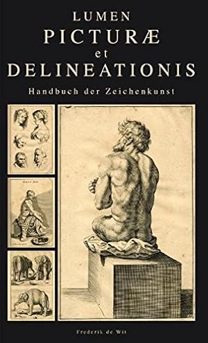
Lumen picturae - Handbuch der Zeichenkunst.
Librería: ACADEMIA Antiquariat an der Universitõt, Freiburg, Alemania
Miembro de asociaci¾n: BOEV
Calificaci¾n del vendedor: 5 de 5 estrellas
EUR 24,00
EnvĒo por EUR 24,95
Se envĒa de Alemania a Estados Unidos de AmericaCantidad disponible: 1 disponibles
A±adir al carritoCondici¾n: Sehr gut. 171 Seiten. 43 cm Gebunden mit Schutzumschlag. Sehr gut. Sprache: Deutsch Gewicht in Gramm: 2461.
-

Lumen Picturae A Classical Drawing Manual
Idioma: Inglķs
Publicado por Harper Design / Harper Collins, New York, 2011
ISBN 10: 0062048880 ISBN 13: 9780062048882
Librería: Warwick Books, member IOBA, South Pasadena, CA, Estados Unidos de America
Miembro de asociaci¾n: IOBA
Calificaci¾n del vendedor: 5 de 5 estrellas
Original o primera edici¾n
EUR 118,24
EnvĒo por EUR 5,91
Se envĒa dentro de Estados Unidos de AmericaCantidad disponible: 1 disponibles
A±adir al carritoHardcover. Condici¾n: Fine. Estado de la sobrecubierta: Fine. First thus. Hardcover in dust jacket. First Harper Design edition of book first published between 1660 and 1675 in Amsterdam. Three page-intro (in English) followed by 171 pages of full-page depictions of the human body, insects, birds and animals, and mythological and biblical figures. Book is As New, crisp, clean, flawless except for a short black marker line on bottom text block. 4to.
-
Lumen Picturae: A Classical Drawing Manual
Librería: YESIBOOKSTORE, MIAMI, FL, Estados Unidos de America
Calificaci¾n del vendedor: 4 de 5 estrellas
EUR 207,00
Gastos de envĒo gratis
Se envĒa dentro de Estados Unidos de AmericaCantidad disponible: 1 disponibles
A±adir al carritohardcover. Condici¾n: As New.
-
Lumen Picturae: Drawing Art Manual
Librería: Glands of Destiny First Edition Books, Sedro Woolley, WA, Estados Unidos de America
Calificaci¾n del vendedor: 5 de 5 estrellas
Original o primera edici¾n
EUR 437,94
EnvĒo por EUR 6,79
Se envĒa dentro de Estados Unidos de AmericaCantidad disponible: 1 disponibles
A±adir al carritoHardcover. Condici¾n: Like New. Estado de la sobrecubierta: Like New. First Edition. Publisher: FKG/Loft, Barcelona, 2010. FINE folio-size hardcover book in FINE mylar-protected dust-jacket. First Edition Thus. (First published in Amsterdam in 1675.) Text in 6 languages, Including English, Spanish, French and German. First Printing. As new.
-

Lumen Picturae, Handleiding voor de tekenkunst.
Librería: Grimbergen Booksellers, Lisse, Holanda
Calificaci¾n del vendedor: 5 de 5 estrellas
EUR 30,00
EnvĒo por EUR 23,00
Se envĒa de Holanda a Estados Unidos de AmericaCantidad disponible: 1 disponibles
A±adir al carritoBarcelona, Loft Publications, 2010. Hard Cover (with dustjacket). Text in Dutch, German, Spanish, French, Italian and English. 171 pp (nearly all with drawings). Wear to corner top dustjacket. Good copy. 30x43 cm.
-
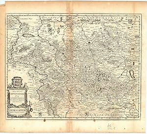
Ducatus Brunsvicensis fereq Lunaeburgensis, cum Adjacentibus Episcopatibus, Comit. Domin. etc.
Publicado por Amsterdam ., 1682
Librería: Robert Frew Ltd. ABA ILAB, London, Reino Unido
Miembro de asociaci¾n: ABA ILAB PBFA
Calificaci¾n del vendedor: 5 de 5 estrellas
Mapa
EUR 58,71
EnvĒo por EUR 11,40
Se envĒa de Reino Unido a Estados Unidos de AmericaCantidad disponible: 1 disponibles
A±adir al carritoOriginal uncoloured double-page copper engraved map with a decorative cartouche to lower left corner. Map dimensions 28 x 36 cm, overall sheet dimensions 34.5 x 39 cm. Light toning and a few nicks to margins, lightly toned down centre-fold, generally very good condition.
-

Lumen picturae - Handbuch der Zeichenkunst. Hrsg.: Paco Asensio. ▄bers.: Equipode Edici¾n, Barcelona.
Librería: Antiquariat Buchseite, Purkersdorf, Austria
Calificaci¾n del vendedor: 5 de 5 estrellas
EUR 25,00
EnvĒo por EUR 72,50
Se envĒa de Austria a Estados Unidos de AmericaCantidad disponible: 1 disponibles
A±adir al carrito2░, Pappband. Condici¾n: Gut. Erstauflage, EA. 171 Seiten Schutzumschlag, Bildband, guter Zustand Sprache: Deutsch Gewicht in Gramm: 2461.
-

Lumen Picturae Handbuch der Zeichenkunst
Idioma: Alemßn
Publicado por K÷ln: Komet Verlag, 2010
Librería: Br³cke Schleswig-Holstein gGmbH, Kiel, Alemania
Calificaci¾n del vendedor: 4 de 5 estrellas
EUR 20,00
EnvĒo por EUR 45,00
Se envĒa de Alemania a Estados Unidos de AmericaCantidad disponible: 1 disponibles
A±adir al carritoGebundene Ausgabe. Condici¾n: Gut. 171 S., m. Abb. Schutzumschlag berieben, Einbandkanten besto▀en, altersgemõ▀e Gebrauchsspuren, guter Zustand, B1 B1 //Rechnung mit ausgewiesener MwSt. liegt bei.// Sprache: Deutsch Gewicht in Gramm: 2422.
-
Animalia ad vivum delineata, et aquaforti aeri impressa, studio et arte Nicolas Berchemi. F. de Wit excudit [4 grabados al aguafuerte]
Publicado por S.l, F. de Wit, s.a. [Amsterdam, ca 1660], 1660
Librería: MIQUELEIZ ANTIGUEDADES, PAMPLONA, NA, Espa±a
Miembro de asociaci¾n: AILA ILAB
Calificaci¾n del vendedor: 5 de 5 estrellas
EUR 250,00
EnvĒo por EUR 30,00
Se envĒa de Espa±a a Estados Unidos de AmericaCantidad disponible: 1 disponibles
A±adir al carritoCondici¾n: Bueno. 4 grabados al aguafuerte enmarcados juntos, 10x13 cm (huella) cada uno.Berchem fue el autor de varias series de aguafuertes dedicadas a representar ovejas y cabras, publicadas por diferentes editores. Aunque de Wit aparece en la cartela como grabador, es muy posible que en realidad fuera editor de la obra, ya que acab¾ dedicßndose mßs a estos menesteres; ademßs, una de las estampas aparece firmada "Berghem ft".
-
Theatrum ichnographicum omnium urbium et praecipuorum oppidorum belgicarum XVIII provinciarum peraccurate delineatarum. Perfecte aftekeningen der steden van de XVII Nederlandsche Provincien in plattegronden. Facs. van de oorspronkelijke eerste druk, verschenen te Amsterdam in ca. 1698. Facs. of the 1st ed., published at Amsterdam c. 1698.
Publicado por Amsterdam, Van Hoeve, 1980., 1980
Librería: Charbo's Antiquariaat, Amsterdam, Holanda
Miembro de asociaci¾n: ILAB NVVA
Calificaci¾n del vendedor: 5 de 5 estrellas
EUR 248,00
EnvĒo por EUR 37,50
Se envĒa de Holanda a Estados Unidos de AmericaCantidad disponible: 1 disponibles
A±adir al carritoCondici¾n: VG/--. Folio. With 128 mostly double-page b/w maps. Index. Hardcover. Or. brown buckram. (Gift dedication on front endpaper). * Incl. booklet: Frederick de Wit, Stedenatlas, Book of towns, Livre des plans des villes (Inleiding en lijst van platen. Nederlandse, Engelse & Franse tekst. Incl. loose appendix with Dutch, English & French introduction and list of plates). - Heavy item, requires extra shipping costs for destinations outside EU.
-
![Imagen del vendedor de Regnorum Castellae Novae, Andalusiae, Granadae, Valentiae, et Murciae [Mapa antiguo de Andalucia, Granada, Murcia, Espa±a] a la venta por Bolivar Old Prints Anticuario](https://pictures.abebooks.com/inventory/md/md31742336249.jpg)
Regnorum Castellae Novae, Andalusiae, Granadae, Valentiae, et Murciae [Mapa antiguo de Andalucia, Granada, Murcia, Espa±a]
Publicado por ┴msterdam, 1710
Librería: Bolivar Old Prints Anticuario, Barcelona, B, Espa±a
Miembro de asociaci¾n: AILA ILAB
Calificaci¾n del vendedor: 5 de 5 estrellas
Mapa
EUR 380,00
EnvĒo por EUR 25,00
Se envĒa de Espa±a a Estados Unidos de AmericaCantidad disponible: 1 disponibles
A±adir al carritoNo Binding. Condici¾n: Bueno. 1688-1710. Muy decorativo mapa del sur de Espa±a que abarca Castilla la Nueva, AndalucĒa, Granada, Valencia y Murcia. Fue publicado en el Atlas Maior, del cart¾grafo holandķs Frederick de Wit. Tiene una sencilla rosa de los vientos coronada por una flor de lis y un bello y muy decorativo tĒtulo rodeado por elementos vegetales, tres puti y cinco escudos de Castilla, AndalucĒa, Valencia, Murcia y Granada, por debajo, las escalas enmarcadas en un recuadro de dise±o arquitect¾nico. Las principales ciudades estßn identificadas pictogrßficamente por una planta amurallada. Impreso con placa de cobre y coloreado a mano. Frederick de Wit (1629-1706) estuvo activo en la segunda mitad del siglo XVII y principios del XVIII, durante la ╔poca de Oro de la cartografĒa holandesa. Naci¾ en la ciudad de Gouda y se traslad¾ a ┴msterdam alrededor de 1648, donde trabaj¾ bajo las ¾rdenes de Willem Blaeu. Adquiri¾ fama y fortuna poco despuķs de la publicaci¾n de sus primeros mapas, tanto como grabador, como cart¾grafo. En 1689 le fue conferido un privilegio de 15 a±os que protegĒa su derecho a imprimir y publicar sus propios mapas. Muri¾ en 1706 y su esposa se encarg¾ de seguir publicando sus mapas hasta 1710. Cuando ella se retir¾ del negocio vendi¾ los mapas y placas de De Wit en una subasta p·blica. La mayorĒa fue adquirida por Pierre Mortier, lo que sirvi¾ como cimiento para su pr¾spera firma Covens & Mortier, la casa editorial cartogrßfica holandesa mßs grande del siglo XVIII. 48 x 57 cm. 7078 Map Carte Regnorum Castellae Novae, Andalusiae, Granadae, Valentiae, et Murciae ┴msterdam Wit, Frederick de 1710 Very good 380. FRA. Very good.
-
![Imagen del vendedor de [SUD AMERICA] Terra Nova ac Maris Tractus circa Novam Franciam, Angliam, Belgium, Venezuelam novam, Andalusiam, Guyanam et Brasiliam. a la venta por Libreria Antiquaria Pregliasco](https://pictures.abebooks.com/inventory/md/md32196052189.jpg)
[SUD AMERICA] Terra Nova ac Maris Tractus circa Novam Franciam, Angliam, Belgium, Venezuelam novam, Andalusiam, Guyanam et Brasiliam.
Publicado por Amsterdam, 1680, , Amsterdam, 1680
Librería: Libreria Antiquaria Pregliasco, Torino, TO, Italia
Miembro de asociaci¾n: ALAI ILAB
Calificaci¾n del vendedor: 5 de 5 estrellas
EUR 1.100,00
EnvĒo por EUR 35,00
Se envĒa de Italia a Estados Unidos de AmericaCantidad disponible: 1 disponibles
A±adir al carritoCondici¾n: Good. Incisione in rameĀĀ(mm. 490x570) con bellissima colorazione coeva, verso velato da finissimo foglio di carta Giappone.Bella e rara carta nautica, tratta dal celebre atlante di De Witt ''Orbis Maritimus ofte Zee Atlas?, che mostra l'Oceano Atlantico a ovest delle Azzorre e delle isole di Capo Verde e le coste del Nord America nord-orientale e del Sud America settentrionale. La carta Ķ orientata con il nord a sinistra.Ā Le indicazioni toponimiche e le caratteristiche geografiche sono strettamente limitate alle coste. Rosa dei venti, linee lossodromicheĀ e Ādue cartigli decorativi in, uno in basso in centro e uno a destra, con varie figure, anche allegoriche, nativi e animali locali, che includono il titolo in latino e in olandese."Frederick de Wit deve essere considerato uno dei pi∙ importanti editori di mappe della seconda metÓ del XVII secolo. La maggior parte delle sue mappe sono di ottima qualitÓ, sono caratterizzate da un'incisione chiara e bella, dall'attualitÓ e ricchezza dell'immagine cartografica nonchķ dall'equilibrio delle decorazioni cartografiche? (Lexikon der Kartographie II, p. 899), Koeman M. Wit 1, 27.Ā Koeman, Atlantes Neerlandici, IV, pp.191 e 518-519. Shirley 444. Putnam, Early sea charts, 75. Book.
-
[CANALE DELLA MANICA] Mare Germanicum ab Amelandia ad Promontoria Caleti et Doverae. Pascart van de Noord Zee van Amelandt tot de Hoofden.
Publicado por Amsterdam, 1680, Amsterdam, 1680
Librería: Libreria Antiquaria Pregliasco, Torino, TO, Italia
Miembro de asociaci¾n: ALAI ILAB
Calificaci¾n del vendedor: 5 de 5 estrellas
EUR 1.200,00
EnvĒo por EUR 35,00
Se envĒa de Italia a Estados Unidos de AmericaCantidad disponible: 1 disponibles
A±adir al carritoCondici¾n: molto buono. Incisione in rame (mm. 525x630), abilmente dipinta da mano coeva. Book.
-
Atlas
Publicado por Federick de Wit, 1680
Librería: Arader Galleries - AraderNYC, New York, NY, Estados Unidos de America
Calificaci¾n del vendedor: 5 de 5 estrellas
EUR 109.483,79
Gastos de envĒo gratis
Se envĒa dentro de Estados Unidos de AmericaCantidad disponible: 1 disponibles
A±adir al carritoHardcover. Condici¾n: Very Good. Amsterdam: Frederick de Wit, [ca 1680]. Folio (20 4/8 x 12 4/8 inches). Engraved allegorical title-page with letterpress index on verso (re-margined at an early date) and 28 double-page maps, including two folding, all in contemporary hand colour. Bound in contemporary gilt-panelled calf Cover. Worn at extremities and repaired at the head of the spine. Several maps with early repairs to versos at folds. 19th-century North Library bookplate of the Earls of Macclesfield on the front paste-down dated 1860, discreet blind-stamp on the title-page and world map. An early atlas with maps relating to America including the double-hemisphere world map "Nova Orbis Tabula" with two smaller hemispheres in the cusps and an elaborate allegorical border showing the four seasons and the zodiac, California as an island, and the western and northern coastline of Australia is emerging; "Novissima et Accuratissima totius Americae" of North and South America shows California as an island; "Asiae" and "Tabula Indiae" both depict the northern coastline of Australia. De Wit (1629-1706) was born in Gouda and became one of the most famous engravers of maps of the second half of the 17th-century. His earliest maps were issued in 1654. In addition to being geographically correct, de Wit's maps are full of detail and are often decorated with elaborate cartouches. "Frederick de Wit, who was the sole proprietor of the firm, was not just a conveyor of maps but also an innovator in the field of commercial cartography. His maps and in particular his atlas production changed the form in which atlases were consumed in the second half of the seventeenth century. de Wit produced and successfully marketed the first concise reference atlas. de Wit's cartographic production is one of the key factors that joined the early Netherlands period in cartography ca 1550 to ca. 1675, to the latter years of Dutch commercial cartography, and European atlas production in the eighteenth century" (George Carhart). Koeman III, Wit 4.
-
![Imagen del vendedor de [SUD AMERICA] Nova Hispaniae, Chili, Peruviae, et Guatimalae Littorae a la venta por Libreria Antiquaria Pregliasco](https://pictures.abebooks.com/inventory/md/md31426593458.jpg)
[SUD AMERICA] Nova Hispaniae, Chili, Peruviae, et Guatimalae Littorae
Publicado por Amsterdam, 1680 , Amsterdam, 1680
Librería: Libreria Antiquaria Pregliasco, Torino, TO, Italia
Miembro de asociaci¾n: ALAI ILAB
Calificaci¾n del vendedor: 5 de 5 estrellas
EUR 1.200,00
EnvĒo por EUR 35,00
Se envĒa de Italia a Estados Unidos de AmericaCantidad disponible: 1 disponibles
A±adir al carritoCondici¾n: Good. Incisione in rameĀĀsu doppio foglio (cm.50x57 circa) con bellissima colorazione coeva, verso velato da finissimo foglio di carta Giappone.Bella e rara carta nautica,Ā tratta dal celebre atlante di De Witt ''Orbis Maritimus ofte Zee Atlas?, che copre le coste dell'America Centrale, Per∙, Cile, Jamaica e parte di Cuba e Porto Rico. . Le indicazioni toponimiche e le caratteristiche geografiche sono strettamente limitate alle coste. Rosa dei venti, linee lossodromiche e splendido cartiglio, in basso a destra, con titolo in latino, con ricche decorazioni colorate raffiguranti varie figure, anche allegoriche."Frederick de Wit deve essere considerato uno dei pi∙ importanti editori di mappe della seconda metÓ del XVII secolo. La maggior parte delle sue mappe sono di ottima qualitÓ, sono caratterizzate da un'incisione chiara e bella, dall'attualitÓ e ricchezza dell'immagine cartografica nonchķ dall'equilibrio delle decorazioni cartografiche? (Lexikon der Kartographie II, p. 899), Koeman M. Wit 1, 27.Koeman, Atlantes Neerlandici, IV, pp.191 e 518-519. Shirley 444. Putnam, Early sea charts, 75. Book.
-
![Imagen del vendedor de [NORD AFRICA] Barbariae et Guineae aritimi a Freto Gibraltar ad Fluvium Gambiae cum Insulis Salfis Flandricis et Canaricis. a la venta por Libreria Antiquaria Pregliasco](https://pictures.abebooks.com/inventory/md/md31426582593.jpg)
[NORD AFRICA] Barbariae et Guineae aritimi a Freto Gibraltar ad Fluvium Gambiae cum Insulis Salfis Flandricis et Canaricis.
Publicado por Amsterdam, 1680, Amsterdam, 1680
Librería: Libreria Antiquaria Pregliasco, Torino, TO, Italia
Miembro de asociaci¾n: ALAI ILAB
Calificaci¾n del vendedor: 5 de 5 estrellas
EUR 1.200,00
EnvĒo por EUR 35,00
Se envĒa de Italia a Estados Unidos de AmericaCantidad disponible: 1 disponibles
A±adir al carritoCondici¾n: Good. Bella e rara carta nautica,Ā tratta dal celebre atlante di De Witt ''Orbis Maritimus ofte Zee Atlas?, che mostra l'Africa occidentale con le Isole Canarie e Capo Verde nell'Oceano Atlantico. La mappa Ķ dotata di due rose dei venti e battaglie navali. L'immagine della mappa Ķ orientata con il Nord verso l'Est. Cartiglio ricco e dettagliato con titolo in latino, con immagini di nativi e di commercianti occidentali, oltre ad animali del luogo."Frederick de Wit deve essere considerato uno dei pi∙ importanti editori di mappe della seconda metÓ del XVII secolo. La maggior parte delle sue mappe sono di ottima qualitÓ, sono caratterizzate da un'incisione chiara e bella, dall'attualitÓ e ricchezza dell'immagine cartografica nonchķ dall'equilibrio delle decorazioni cartografiche? (Lexikon der Kartographie II, p. 899), Koeman M. Wit 1, 27.Koeman, Atlantes Neerlandici, IV, pp.191 e 518-519. Shirley 444. Putnam, Early sea charts, 75. Book.
-
![Imagen del vendedor de [SUD AFRICA] Cimbebas et Caffariae Littora a Catenbela ad Promontorium Bonae Spei. Pascaerte van Cimbebas en Caffares Streckende van Catembela tot Cabo de Bona Esperanca. a la venta por Libreria Antiquaria Pregliasco](https://pictures.abebooks.com/inventory/md/md31426577451.jpg)
[SUD AFRICA] Cimbebas et Caffariae Littora a Catenbela ad Promontorium Bonae Spei. Pascaerte van Cimbebas en Caffares Streckende van Catembela tot Cabo de Bona Esperanca.
Publicado por Amsterdam, 1680, Amsterdam, 1680
Librería: Libreria Antiquaria Pregliasco, Torino, TO, Italia
Miembro de asociaci¾n: ALAI ILAB
Calificaci¾n del vendedor: 5 de 5 estrellas
EUR 1.300,00
EnvĒo por EUR 35,00
Se envĒa de Italia a Estados Unidos de AmericaCantidad disponible: 1 disponibles
A±adir al carritoCondici¾n: Good. Incisione in rame(mm 436x549) con bellissima colorazione coeva, verso velato da finissimo foglio di carta Giappone.Bella e rara carta nautica,Ā tratta dal celebre atlante di De Witt ''Orbis Maritimus ofte Zee Atlas?, della costa atlantica meridionale dell'Africa. Nel cartiglio titolo in latino e olandese: a sinistra un gruppo di europei che conducono negoziati commerciali. Al centro, tre leoni, un leopardo e un serpente dividono il cartiglio. Sulla destra due nativi. In basso a destra della carta nautica sono rappresentati Nettuno e una figura femminile, trainati su un carro da tre cavalli. La costa presenta molte insenature e l'isola di S. Elena Nuova Ķ un po' pi∙ a sud del solito. Ā"Frederick de Wit deve essere considerato uno dei pi∙ importanti editori di mappe della seconda metÓ del XVII secolo. La maggior parte delle sue mappe sono di ottima qualitÓ, sono caratterizzate da un'incisione chiara e bella, dall'attualitÓ e ricchezza dell'immagine cartografica nonchķ dall'equilibrio delle decorazioni cartografiche? (Lexikon der Kartographie II, p. 899), Koeman M. Wit 1, 27.ĀĀ Koeman, Atlantes Neerlandici, IV, pp.191 e 518-519. Shirley 444. Putnam, Early sea charts, 75. Book.
-
![Imagen del vendedor de [NORD EUROPA] Daniae, Frisiae, Groningae et Orientalis Frisiae Littora a la venta por Libreria Antiquaria Pregliasco](https://pictures.abebooks.com/inventory/md/md31426567566.jpg)
[NORD EUROPA] Daniae, Frisiae, Groningae et Orientalis Frisiae Littora
Publicado por Amsterdam, 1680 , Amsterdam, 1680
Librería: Libreria Antiquaria Pregliasco, Torino, TO, Italia
Miembro de asociaci¾n: ALAI ILAB
Calificaci¾n del vendedor: 5 de 5 estrellas
EUR 1.100,00
EnvĒo por EUR 35,00
Se envĒa de Italia a Estados Unidos de AmericaCantidad disponible: 1 disponibles
A±adir al carritoCondici¾n: Good. Incisione in rame (cm.50x57 circa) con bellissima colorazione coeva, verso velato da finissimo foglio di carta Giappone.Bella e rara carta nautica,Ā tratta dal celebre atlante di De Witt ''Orbis Maritimus ofte Zee Atlas?, del Mare del Nord con parti della costa di Svezia, Norvegia, Danimarca, Germania e Olanda, tratta dal celebre atlante di De Witt ''Orbis Maritimus ofte Zee Atlas' Amsterdam",Ādal titolo "Daniae, Frisiae, Groningae et Orientalis Frisiae Littora",Āorientata a ovest del Mar Baltico e del Nord da Amsterdam e Zuidersee attraverso le isole Frisone occidentali, orientali e settentrionali, la Danimarca e Rostock fino alla costa occidentale svedese.ĀIl dettagliato cartiglio del titolo mostra le allegorie del commercio, della prosperitÓ e dell'agricoltura. Mercurio e Fortuna negoziano il valore di una cornucopia. La figura fanciullesca di Plutone, personificazione della ricchezza, e il dio pastore Pan drappeggiano le merci. Un dio fluviale versa l'acqua dalla sua anfora sul titolo. Al di sotto di questo, si pu“ osservare una specie di scena di mercato. Le parti del paese sono differenziate per colore, si notano le cittÓ costiere.Ā Una battaglia navale e rose dei venti arricchiscono l'immagine della mappa.ĀBellissima carta arricchita da cartouche figurata per il titolo, armi araldiche, navi, figure allegoriche.Ā Koeman, Atlantes Neerlandici, IV, pp.191 e 518-519. Shirley 444. Putnam, Early sea charts, 75. Book.
-
![Imagen del vendedor de [AFRICA] Tractus Littorales Guineae a Promontorio Verde Usque ad Sinum Catenbelae a la venta por Libreria Antiquaria Pregliasco](https://pictures.abebooks.com/inventory/md/md31421181590.jpg)
[AFRICA] Tractus Littorales Guineae a Promontorio Verde Usque ad Sinum Catenbelae
Publicado por Amsterdam, 1680, Amsterdam, 1680
Librería: Libreria Antiquaria Pregliasco, Torino, TO, Italia
Miembro de asociaci¾n: ALAI ILAB
Calificaci¾n del vendedor: 5 de 5 estrellas
EUR 1.100,00
EnvĒo por EUR 35,00
Se envĒa de Italia a Estados Unidos de AmericaCantidad disponible: 1 disponibles
A±adir al carritoCondici¾n: Good. Incisione in rame (mm. 525x630), abilmente dipinta da mano coeva,Āverso velato da finissimo foglio di carta Giappone. Bella e rara carta nautica, tratta dal celebre atlante di De Witt ''Orbis Maritimus ofte Zee Atlas?: la mappa si estende dal Senegal a nord fino all'Angola a sud, centrata sulla Baia di Guinea. Le indicazioni toponimiche e le caratteristiche geografiche sono strettamente limitate alle coste. Rosa dei venti, linee lossodromiche e splendido cartiglio, in alto, dove commercianti olandesi contrattano per gli schiavi ammanettati con i capi indigeni. Sullo sfondo si pu“ vedere una fornace che fonde quello che presumibilmente Ķ oro.ĀL'abile rinforzo con carta Giappone evita il deperimento da aciditÓ ai verdi e marroni; quindi l'esemplare si presenta in ottimo stato, anche grazie alla splendida coloritura del cartiglio."Frederick de Wit deve essere considerato uno dei pi∙ importanti editori di mappe della seconda metÓ del XVII secolo. La maggior parte delle sue mappe sono di ottima qualitÓ, sono caratterizzate da un'incisione chiara e bella, dall'attualitÓ e ricchezza dell'immagine cartografica nonchķ dall'equilibrio delle decorazioni cartografiche? (Lexikon der Kartographie II, p. 899), Koeman M. Wit 1, 27.Ā Koeman, Atlantes Neerlandici, IV, pp.191 e 518-519. Shirley 444. Putnam, Early sea charts, 75. Book.
-
![Imagen del vendedor de [NORD AMERICA] Septemtrionaliora Americae a Groenlandia, per Freta Davidis et Hudson, ad Terram Novam. a la venta por Libreria Antiquaria Pregliasco](https://pictures.abebooks.com/inventory/md/md31421173174.jpg)
[NORD AMERICA] Septemtrionaliora Americae a Groenlandia, per Freta Davidis et Hudson, ad Terram Novam.
Publicado por Amsterdam, 1680 , Amsterdam, 1680
Librería: Libreria Antiquaria Pregliasco, Torino, TO, Italia
Miembro de asociaci¾n: ALAI ILAB
Calificaci¾n del vendedor: 5 de 5 estrellas
EUR 1.600,00
EnvĒo por EUR 35,00
Se envĒa de Italia a Estados Unidos de AmericaCantidad disponible: 1 disponibles
A±adir al carritoCondici¾n: Good. Incisione in rameĀĀ(mm. 497x570)Ā con bellissima colorazione coeva, verso velato da finissimo foglio di carta Giappone.Bella e rara carta nautica, tratta dal celebre atlante di De Witt ''Orbis Maritimus ofte Zee Atlas?, mostra alcune delle prime mappe provvisorie della regione. Basato sulla precedente carta di Van Loon del 1666, raffigura l'America settentrionale, la baiaĀ e lo stretto di Hudson, la baia di Baffin, un'isola di Baffin allargata, la baia di James e la baia di Buttons, l'Isola di Terranova e, attraverso il mare, fino alla costa occidentale della Groenlandia. Interessante l'indicazione, in basso, nell'istmo tra la Baia di James e quella di Great, "Hic hibernavit Hudson". Rosa dei venti, linee lossodromiche e una battaglia navale nei pressi dello stretto di Hudson.Scale metriche in miliaria gallica e miliaria tedesca.Riccamente impreziosito da due elaborati cartigli, uno in latino e uno in olandese, decorati da indigeni e colonizzatori, intenti in scambi commerciali.L'abile velatura al verso evita alla cartaĀ l'aciditÓ causata da alcuni pigmenti dei colori dell'epoca; quindi l'esemplare si presenta in ottimo stato, anche grazie alla splendida coloritura del cartiglio."Frederick de Wit deve essere considerato uno dei pi∙ importanti editori di mappe della seconda metÓ del XVII secolo. La maggior parte delle sue mappe sono di ottima qualitÓ, sono caratterizzate da un'incisione chiara e bella, dall'attualitÓ e ricchezza dell'immagine cartografica nonchķ dall'equilibrio delle decorazioni cartografiche? (Lexikon der Kartographie II, p. 899), Koeman M. Wit 1, 27.Koeman, Atlantes Neerlandici, IV, pp.191 e 518-519. Shirley 444. Putnam, Early sea charts, 75. Book.
-
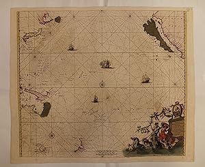
Magnum Mare del Zur cum Insula California.
Publicado por Amsterdam, 1680, Amsterdam, 1680
Librería: Libreria Antiquaria Pregliasco, Torino, TO, Italia
Miembro de asociaci¾n: ALAI ILAB
Calificaci¾n del vendedor: 5 de 5 estrellas
EUR 2.000,00
EnvĒo por EUR 35,00
Se envĒa de Italia a Estados Unidos de AmericaCantidad disponible: 1 disponibles
A±adir al carritoCondici¾n: Good. Incisione in rameĀĀ(mm. 497x570) su doppio foglio con bellissima colorazione coeva, verso velato da finissimo foglio di carta Giappone.Bella e rara carta nautica -tratta dal celebre atlante di De Witt ''Orbis Maritimus ofte Zee Atlas?- che raffigura l'Oceano Pacifico, la California, il Giappone, la Nuova Guinea e la Nuova Zelanda. La particolaritÓ di questa carta Ķ la rappresentazione della California come isola, a testimonianza della differente concezione geografica nel 1600 rispetto ad oggi. Inoltre, rispetto ad altre mappe del Mar del Zur (Oceano Pacifico), questo esemplare si estende ad Ovest della costa californiana fino al Giappone.In basso a destra un grande e decorativo cartiglio raffigurante Nettuno su un carro sovrastato dal ritratto di Magellano entro medaglione.Ā L'abile rinforzo con carta Giappone evita il deperimento da aciditÓ ai verdi e marroni; quindi l'esemplare si presenta in ottimo stato, anche grazie alla splendida coloritura del cartiglio."Frederick de Wit deve essere considerato uno dei pi∙ importanti editori di mappe della seconda metÓ del XVII secolo. La maggior parte delle sue mappe sono di ottima qualitÓ, sono caratterizzate da un'incisione chiara e bella, dall'attualitÓ e ricchezza dell'immagine cartografica nonchķ dall'equilibrio delle decorazioni cartografiche? (Lexikon der Kartographie II, p. 899), Koeman M. Wit 1, 27.Koeman, Atlantes Neerlandici, IV, pp.191 e 518-519. Shirley 444. Putnam, Early sea charts, 75.[AMERICA & OCEANIA]. Book.
-
![Imagen del vendedor de [SPAGNA & FRANCIA] Galliae, Biscajae et Gallissiae Sinus a la venta por Libreria Antiquaria Pregliasco](https://pictures.abebooks.com/inventory/md/md31419375920.jpg)
[SPAGNA & FRANCIA] Galliae, Biscajae et Gallissiae Sinus
Publicado por Amsterdam, 1680, , Amsterdam, 1680
Librería: Libreria Antiquaria Pregliasco, Torino, TO, Italia
Miembro de asociaci¾n: ALAI ILAB
Calificaci¾n del vendedor: 5 de 5 estrellas
EUR 1.000,00
EnvĒo por EUR 35,00
Se envĒa de Italia a Estados Unidos de AmericaCantidad disponible: 1 disponibles
A±adir al carritoCondici¾n: molto buono. Acquaforte di 490x570 mm. Incisione in rame su doppio foglio (cm.50x57 circa) con bellissima colorazione coeva, verso velato da finissimo foglio di carta Giappone. Bella e rara carta nautica -tratta dal celebre atlante di De Witt ''Orbis Maritimus ofte Zee Atlas"- che copre dalle coste della Bretagna, a quella cantabrica spagnola e della Galizia fino all'altezza di Pontevedra. Sono rappresentati linee di corsi, fondali, ancoraggi, secche e toponomastica costiera. Il cartiglio nella parte centrale inferiore Ķ composto da due mostri marini, il Vello d'Oro, tre cartografiĀ e un aborigeno che sorregge un parasole. In alto a destra un secondo cartiglio con un cavaliere, uno scudo con tre gigli francesi e un fauno che sorregge grappoli d'uva mentre due figure bevono da grandi coppe. L'abile rinforzo con carta Giappone evita il deperimento da aciditÓ ai verdi e marroni; quindi l'esemplare si presenta in ottimo stato, anche grazie alla splendida coloritura dei cartigli."Frederick de Wit deve essere considerato uno dei pi∙ importanti editori di mappe della seconda metÓ del XVII secolo. La maggior parte delle sue mappe sono di ottima qualitÓ, sono caratterizzate da un'incisione chiara e bella, dall'attualitÓ e ricchezza dell'immagine cartografica nonchķ dall'equilibrio delle decorazioni cartografiche? (Lexikon der Kartographie II, p. 899), Koeman M. Wit 1, 27. Book.
-
Accuratissima Principatus Cataloniae [Mapa de Catalu±a]
Publicado por Amsterdam, 1688
Librería: Bolivar Old Prints Anticuario, Barcelona, B, Espa±a
Miembro de asociaci¾n: AILA ILAB
Calificaci¾n del vendedor: 5 de 5 estrellas
Mapa
EUR 650,00
EnvĒo por EUR 25,00
Se envĒa de Espa±a a Estados Unidos de AmericaCantidad disponible: 1 disponibles
A±adir al carritoNo Binding. Condici¾n: Bueno. 49 x 57 cm. Impactante y escaso mapa a color de Catalu±a del holandķs Frederick de Wit. Muestra el territorio del Rosell¾n como parte de Catalu±a y destaca ciudades como Lķrida, Balaguer, Tortosa, Tarragona, Cardona, PuigcerdÓ, Solsona, Girona, Rosas, Villafranca y Barcelona. Cuenta con un decorativo cartouche que representa a unos putti sosteniendo un lienzo con el tĒtulo. Colores originales aplicados a mano, con aplicaciones de hoja de oro. Frederick de Wit (1629-1706) fue un cart¾grafo holandķs activo en la segunda mitad del siglo XVII y principios del XVIII, durante la ╔poca de Oro de la cartografĒa holandesa. Naci¾ en la ciudad de Gouda y se traslad¾ a ┴msterdam alrededor de 1648, donde trabaj¾ bajo las ¾rdenes de Willem Blaeu. Adquiri¾ fama y fortuna poco despuķs de la publicaci¾n de sus primeros mapas, tanto como grabador, como cart¾grafo. En 1689 le fue conferido un privilegio de 15 a±os que protegĒa su derecho a imprimir y publicar sus propios mapas. Muri¾ en 1706 y su esposa se encarg¾ de seguir publicando sus mapas hasta 1710. Cuando ella se retir¾ del negocio vendi¾ los mapas y placas de De Wit en una subasta p·blica. La mayorĒa fue adquirida por Pierre Mortier, lo que sirvi¾ como cimiento para su pr¾spera firma Covens & Mortier, la casa editorial cartogrßfica holandesa mßs grande del siglo XVIII. TĒtulo completo: Accuratissima Principatus Cataloniae et Comitatuum Ruscinonis et Cerrataniae Descriptio per F. de Wit. Scarce Dutch map of Catalonia, Spain. Full English description upon request. FRA. Muy bien.
-
![Imagen del vendedor de [ AFRICA ] Totius Africae Accuratissima Tabula a la venta por Libreria Antiquaria Pregliasco](https://pictures.abebooks.com/inventory/md/md20885757048.jpg)
[ AFRICA ] Totius Africae Accuratissima Tabula
Publicado por Amsterdam, 1680,, 1680
Librería: Libreria Antiquaria Pregliasco, Torino, TO, Italia
Miembro de asociaci¾n: ALAI ILAB
Calificaci¾n del vendedor: 5 de 5 estrellas
EUR 1.600,00
EnvĒo por EUR 35,00
Se envĒa de Italia a Estados Unidos de AmericaCantidad disponible: 1 disponibles
A±adir al carritoCondici¾n: molto buono. Incisione in rame (cm 52.5x61.8) con magnifica colorazione diĀmano coeva. Splendida mappa dell'intero continente africano, incluso il Madagascar, titolo entro cartouche al margine inferiore sinistro Ķ decorato con figure di indigeni, leoni ed elefanti. Ottimo esemplare, freschissimo, di questa carta disegnata originariamente da Justus Danckerts e poi ripresa da De Wit per il suo atlante.Ā. Book.
-
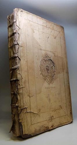
Atlas
Publicado por Amsterdam
Librería: Argosy Book Store, ABAA, ILAB, New York, NY, Estados Unidos de America
Miembro de asociaci¾n: ABAA ILAB
Calificaci¾n del vendedor: 5 de 5 estrellas
EUR 52.552,22
EnvĒo por EUR 5,10
Se envĒa dentro de Estados Unidos de AmericaCantidad disponible: 1 disponibles
A±adir al carritohardcover. Condici¾n: very good(+). Atlas with 104 double page maps and title page in full original color and an index. Folio, measures 22" x 13.5". Bound in original vellum-wrapped wood with gold stamped title and spine; a.e.g. A simple de Wit binding with the Supralibros "Eberhand Nies" and the date of 1690 stamped into the vellum at a later date. Staining to the vellum has weakened the tooling. No printed date or title. Binding separating at spine. Ink notations on title page. Creasing and minor tearing to a few maps, repair to Sicily map. Minor scattered stains and foxing, mainly to margins. Maps are generally in excellent condition. Frederick de Wit (1629/30-1706) was one of the foremost cartographers and map sellers in Amsterdam. He began with a small printing shop in 1654 and soon became internationally known for his city plans and wall maps of the world. His most famous work is the "Theatrum Praecipuarum Totius Europae," published after 1694, which contained 132 plans and views of European and Asian cities. By 1671, he was producing large folio atlases for both his shop and individual patrons that could contain anywhere between 15 and 150 maps. Dr. Carhart notes that De Wit could produce an updated atlas in just 13 days with new information reflected in each edition. His atlases were not composite but official collations. Today, these atlases grace the collections of many museums and institutions as evidence of the vibrant cartographic trade in Amsterdam in the middle- and late-17th century. Maria de Wit ran the company form 1706-1710 before auctioning the firm off.


![Imagen del vendedor de Animalia ad vivum delineata, et aquaforti aeri impressa, studio et arte Nicolas Berchemi. F. de Wit excudit [4 grabados al aguafuerte] a la venta por MIQUELEIZ ANTIGUEDADES](https://pictures.abebooks.com/inventory/md/md32338691950.jpg)
![Imagen del vendedor de Accuratissima Principatus Cataloniae [Mapa de Catalu±a] a la venta por Bolivar Old Prints Anticuario](https://pictures.abebooks.com/inventory/md/md31212705333.jpg)