
Stanford's (43 resultados)

- Tapa blanda
Librería: GreatBookPrices, Columbia, MD, Estados Unidos de AmericaGreatBookPrices
Contactar con el vendedorVendedor de 5 estrellasCondición: Nuevo
EUR 10,26
Envío por EUR 2,31Se envía dentro de Estados Unidos de AmericaCantidad disponible: Más de 20 disponibles
Condición: New.

- Tapa blanda
Librería: BargainBookStores, Grand Rapids, MI, Estados Unidos de AmericaBargainBookStores
Contactar con el vendedorVendedor de 5 estrellasCondición: Nuevo
EUR 12,65
Gastos de envío gratisSe envía dentro de Estados Unidos de AmericaCantidad disponible: 5 disponibles
Paperback or Softback. Condición: New. Natural Effects of Herbal Healing: How to Cure Yourself with Alternative Medicine. Book.

- Tapa blanda
Librería: GreatBookPrices, Columbia, MD, Estados Unidos de AmericaGreatBookPrices
Contactar con el vendedorVendedor de 5 estrellasCondición: Usado - Como Nuevo
EUR 11,08
Envío por EUR 2,31Se envía dentro de Estados Unidos de AmericaCantidad disponible: Más de 20 disponibles
Condición: As New. Unread book in perfect condition.

- Tapa blanda
Librería: Ria Christie Collections, Uxbridge, Reino UnidoRia Christie Collections
Contactar con el vendedorVendedor de 5 estrellasCondición: Nuevo
EUR 14,52
Envío por EUR 14,07Se envía de Reino Unido a Estados Unidos de AmericaCantidad disponible: Más de 20 disponibles
Condición: New. In.
- Tapa blanda
Librería: Chiron Media, Wallingford, Reino UnidoChiron Media
Contactar con el vendedorVendedor de 5 estrellasCondición: Nuevo
EUR 11,54
Envío por EUR 18,19Se envía de Reino Unido a Estados Unidos de AmericaCantidad disponible: 10 disponibles
Paperback. Condición: New.

- Tapa blanda
Librería: GreatBookPricesUK, Woodford Green, Reino UnidoGreatBookPricesUK
Contactar con el vendedorVendedor de 5 estrellasCondición: Nuevo
EUR 14,26
Envío por EUR 17,61Se envía de Reino Unido a Estados Unidos de AmericaCantidad disponible: Más de 20 disponibles
Condición: New.

- Tapa blanda
Librería: Hay-on-Wye Booksellers, Hay-on-Wye, HEREF, Reino UnidoHay-on-Wye Booksellers
Contactar con el vendedorVendedor de 4 estrellasCondición: Usado - Aceptable
EUR 4,17
Envío por EUR 29,35Se envía de Reino Unido a Estados Unidos de AmericaCantidad disponible: 1 disponibles
Condición: Good. A few dirty marks and some shelf wear but content is fine.

- Tapa blanda
Librería: GreatBookPricesUK, Woodford Green, Reino UnidoGreatBookPricesUK
Contactar con el vendedorVendedor de 5 estrellasCondición: Usado - Como Nuevo
EUR 16,24
Envío por EUR 17,61Se envía de Reino Unido a Estados Unidos de AmericaCantidad disponible: Más de 20 disponibles
Condición: As New. Unread book in perfect condition.

Idioma: Inglés
Editorial: Cooking Department of United States Fisheries Association, New York
- Tapa dura
Librería: COOK AND BAKERS BOOKS, PARKSVILLE, VANCOUVER ISLAND, BC, CanadaCOOK AND BAKERS BOOKS
Contactar con el vendedorVendedor de 5 estrellasCondición: Usado - Aceptable
EUR 18,05
Envío por EUR 19,27Se envía de Canada a Estados Unidos de AmericaCantidad disponible: 1 disponibles
Hardcover. Condición: Good. **Bundle Up & Save On Postage** Copyright 1927. Front and back boards have a crack that extends a quarter of the way down the side edge. Rather unfortunate as this is a very attractive book. The decorated yellow boards have light soil and very light edge wear, the interior is in unread condition. 4 X…7" 97 pages. Recipes for fish and seafood approved by Good Housekeeping Institute. Colour photographs.

Librería: Devils in the Detail Ltd, Oxford, Reino UnidoDevils in the Detail Ltd
Contactar con el vendedorVendedor de 5 estrellasCondición: Usado - Bueno
EUR 9,67
Envío por EUR 18,77Se envía de Reino Unido a Estados Unidos de AmericaCantidad disponible: 1 disponibles
Condición: Very Good. Picture Shown is For Illustration Purposes Only, Please See Below For Further DetailsCONDITION ? VERY GOOD - PAPERBACKTHIS IS A FOLDED MAP, light wear and scuff marks to cover, pages in nice condition, shipped from the UK.

Editorial: London , 1938, 1938
- Mapa
Librería: Pennymead Books PBFA, Knaresborough, Reino UnidoPennymead Books PBFA
Contactar con el vendedorVendedor de 5 estrellasMiembro de asociación: PBFA
Condición: Usado
EUR 10,74
Envío por EUR 17,61Se envía de Reino Unido a Estados Unidos de AmericaCantidad disponible: 1 disponibles
Large folding map 25 x 12" showing railways.
Editorial: ‎ Edward Stanford Limited
Librería: D2D Books, Berkshire, Reino UnidoD2D Books
Contactar con el vendedorVendedor de 4 estrellasCondición: Usado - Aceptable
EUR 9,56
Envío por EUR 23,36Se envía de Reino Unido a Estados Unidos de AmericaCantidad disponible: 1 disponibles
No Binding. Condición: Good. ‎ Edward Stanford Limited CIRCA 1967 folding map. Light wear and stains to covers and a small stain to bottom corner of map but still in good tight clean reading order. Full refund if not satisfied. 24 hour dispatch. If not pictured in this listing, a scan of the actual book is available on req…uest. .
- Tapa blanda
- Impresión bajo demanda
Librería: PBShop.store US, Wood Dale, IL, Estados Unidos de AmericaPBShop.store US
Contactar con el vendedorVendedor de 5 estrellasCondición: Nuevo
EUR 16,46
Gastos de envío gratisSe envía dentro de Estados Unidos de AmericaCantidad disponible: Más de 20 disponibles
PAP. Condición: New. New Book. Shipped from UK. THIS BOOK IS PRINTED ON DEMAND. Established seller since 2000.
- Tapa blanda
- Impresión bajo demanda
Librería: PBShop.store UK, Fairford, GLOS, Reino UnidoPBShop.store UK
Contactar con el vendedorVendedor de 5 estrellasCondición: Nuevo
EUR 16,07
Envío por EUR 3,86Se envía de Reino Unido a Estados Unidos de AmericaCantidad disponible: Más de 20 disponibles
PAP. Condición: New. New Book. Delivered from our UK warehouse in 4 to 14 business days. THIS BOOK IS PRINTED ON DEMAND. Established seller since 2000.
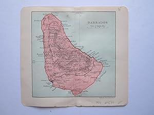
Editorial: Duckworth & Co. London, 1914
- Mapa
Librería: Angelika C. J. Friebe Ltd. - MapWoman, Dorking, Reino UnidoAngelika C. J. Friebe Ltd. - MapWoman
Contactar con el vendedorVendedor de 5 estrellasCondición: Usado - Muy bueno
EUR 18,14
Envío por EUR 23,48Se envía de Reino Unido a Estados Unidos de AmericaCantidad disponible: 1 disponibles
No Binding. Condición: Near Fine. colour printed map; overll 17 x 18 cm. fold as issued; exc. cond. A very attractive map of Barbados from Stanford's "The Pocket Guide to The West Indies"; edited by Algeron E. Aspinall; 3rd edition.
 Más imágenes
Idioma: Inglés
Editorial: Standford's, London, 1951
- Tapa dura
- Mapa
Librería: My Book Shop, Preston, Reino UnidoMy Book Shop
Contactar con el vendedorVendedor de 5 estrellasCondición: Usado - Aceptable
EUR 78,60
Envío por EUR 25,75Se envía de Reino Unido a Estados Unidos de AmericaCantidad disponible: 1 disponibles
Hardcover. Condición: Good. 1951 Stanford's Map of Central London Colour Folding Map George Phillip & Son VG, with Index to streets Scale 4 inches to a 1 mile.

Editorial: Edward Stanford, 1886
- Tapa dura
Librería: Francis Edwards ABA ILAB, Hay on Wye, Reino UnidoFrancis Edwards ABA ILAB
Contactar con el vendedorVendedor de 5 estrellasCondición: Usado
EUR 33,26
Envío por EUR 25,83Se envía de Reino Unido a Estados Unidos de AmericaCantidad disponible: 1 disponibles
3rd Ed. Crown 8vo. [viii] + 135pp. + [i] + [ii] contents + 119pp. + [i] + [xxiv] publ. cat. Folding map frontiss., plan. Hinges tender but firm, e.ps. lightly spotted, original gilt lettered terracotta cloth with blind ruled edges, some minor soiling, head and tail of spine sl. bumped. US$37.

Editorial: A & C Black, UK, 1872
- Tapa blanda
Librería: Maynard & Bradley, Leicester, Reino UnidoMaynard & Bradley
Contactar con el vendedorVendedor de 5 estrellasCondición: Usado - Bueno
EUR 39,85
Envío por EUR 25,77Se envía de Reino Unido a Estados Unidos de AmericaCantidad disponible: 1 disponibles
Softcover. Condición: Very Good. 1872. A generally very well-preserved map engraving, some small nicks and tears at corners repaired with conservation tape but largely free from wear, some mild browning towards edges but no major marks to printed image. Lightly coloured delineating borders, overall clear and attractive. Why on A…mazon do most sellers not describe their actual book? Buy with confidence and support a genuine Independent Bricks & Mortar Real Bookshop. We are Maynard & Bradley CAMBO & PBFA(now lapsed) members here in Leicester City Centre. Size: 460 x 360 mm. 1 pages. Item Type: Book. Quantity Available: 1. Shipped Weight: Under 1 kilogram. Category: Geography & Maps; Britain/UK; 19th century; Pictures of this item not already displayed here available upon request. Inventory No: 22899.
 Más imágenes
Idioma: Inglés
Editorial: Edward Stanford, London, 1914
- Tapa dura
- Mapa
Librería: Dendera, London, Reino UnidoDendera
Contactar con el vendedorVendedor de 5 estrellasCondición: Usado - Aceptable
EUR 211,62
Envío por EUR 29,35Se envía de Reino Unido a Estados Unidos de AmericaCantidad disponible: 1 disponibles
Hardcover. Condición: Good. Colour map 73 x 56cm, dissected in 18 sections and mounted on linen, folding into the original red cloth case 13 x 19cm with Stanford's title label to the front, and adverts inside. Map good, tanned with cloth bleeding and damp staining to verso. Case acceptable only, heavily damp stained, though stru…cturally sound. Dated 12 August 1914, 8 days after Britain declared war on Germany. It covers the British Isles, Faroe Islands, Benelux, Denmark, most of Germany, Southern Scandinavia and parts of France, Russia & Austria-Hungary on a scale of 50.8235 miles to 1 inch or 1:3,220,177. This map was updated as the war progressed. Rare - 10 copies of all editions on Worldcat and Jisc (20 Aug 1914, 1916, 1917).
Idioma: Inglés
Editorial: London Stanford, 1876
- Tapa dura
Librería: Antiquariat Gerhard Gruber, Heilbronn, AlemaniaAntiquariat Gerhard Gruber
Contactar con el vendedorVendedor de 4 estrellasCondición: Usado
EUR 715,00
Envío por EUR 40,00Se envía de Alemania a Estados Unidos de AmericaCantidad disponible: 1 disponibles
(63 x 103 cm). Farbig lithographierte und auf Leinwand aufgezogene Karte in 27 Segmenten. In Original-Leinwandmappe. Beeindruckend großformatige Karte der Vereinigten Staaten von dem herausragenden britischen Verleger Edward Stanford. Es handelt sich um eine allgemeine geographische und politische Karte, deren Schwerpunkt jedoch… eindeutig auf dem wachsenden amerikanischen Eisenbahnnetz liegt. Das Thema war besonders für die britische Öffentlichkeit von großem Interesse, da sie stark in amerikanische Eisenbahnpapiere investiert hatte. - Edward Stanford (1827-1904) gründete eine Karten- und eine Buchhandlung mit Sitz in London und Bristol. Er gilt als der einzige Kartenspezialist seiner Zeit in London. - Mappe gering bestoßen, sonst sauber und wohlerhalten.
Idioma: Inglés
Editorial: Edward Stanford, 55 Charing Cross, London, 1875
- Tapa blanda
Librería: THOMAS RARE BOOKS, Yaxley, SUFFOLK, Reino UnidoTHOMAS RARE BOOKS
Contactar con el vendedorVendedor de 4 estrellasCondición: Usado - Excelente
EUR 1451,13
Envío por EUR 17,61Se envía de Reino Unido a Estados Unidos de AmericaCantidad disponible: 1 disponibles
paper wrappers. Condición: Fine. 1st issue. 78.5 x 66.5 cms. The rare first issue of Stanford's April 19th 1875 map of the North Pole. Laid on cloth in 12 dissected sections. Coloured printing. Pasted to the lower left corner is a contemporary inset map of the Kennedy Channel entering ther 'frozen Polar Ocean', [text to the reve…rse of the inset map].The voyages and journeys of the Artic explorers throughout the centeries are neatly printed in red throughout the map with dates including up to Austrian Exped., Payer 1874. Neatly enclosed in cloth covers when folded with a hand-written original label 'North Pole'. A lovely copy of a very scarce item. PLEASE EMAIL FOR PHOTOS.
- Tapa blanda
- Impresión bajo demanda
Librería: THE SAINT BOOKSTORE, Southport, Reino UnidoTHE SAINT BOOKSTORE
Contactar con el vendedorVendedor de 5 estrellasCondición: Nuevo
EUR 14,28
Envío por EUR 14,28Se envía de Reino Unido a Estados Unidos de AmericaCantidad disponible: Más de 20 disponibles
Paperback / softback. Condición: New. This item is printed on demand. New copy - Usually dispatched within 5-9 working days.
Editorial: Smithsonian Institution. Contributions to Anthropology, No. 20, 1976
Librería: Ethnographic Arts Publications, Mill Valley, CA, Estados Unidos de AmericaEthnographic Arts Publications
Contactar con el vendedorVendedor de 1 estrellasCondición: Usado
EUR 61,35
Envío por EUR 5,17Se envía dentro de Estados Unidos de AmericaCantidad disponible: 2 disponibles
226 pages, 119 pages of photographs illustrating over 1,000 objects.

Editorial: Edward Stanford [c.1930], 1930
- Tapa dura
- Mapa
Librería: Island Books, Thakeham, West Sussex, Reino UnidoIsland Books
Contactar con el vendedorVendedor de 4 estrellasCondición: Usado
EUR 72,56
Envío por EUR 27,24Se envía de Reino Unido a Estados Unidos de AmericaCantidad disponible: 1 disponibles
8vo., folding coloured map on cloth measuring 28 x 34 inches (approx. 71 x 86 cms) folding in 32 panels to 7 x 4.5 inches (approx. 18 x 12 cms); strongly bound in burgundy cloth, upper board lettered in gilt, marbled endpapers, a near fine copy. VERY SCARCE IN THIS CONDITION.
Editorial: Edward Stanford Ltd. N.d. c., 1950
Librería: Francis Edwards ABA ILAB, Hay on Wye, Reino UnidoFrancis Edwards ABA ILAB
Contactar con el vendedorVendedor de 5 estrellasCondición: Usado
EUR 53,21
Envío por EUR 25,83Se envía de Reino Unido a Estados Unidos de AmericaCantidad disponible: 1 disponibles
Reprint of the 1938 Revised Copy. 125 x 8.5 inches. Folding into sl. worn original card wrapps. US$59.
 Más imágenes
Editorial: Edward Stanford, London, 1877
- Tapa dura
- Mapa
Librería: Dendera, London, Reino UnidoDendera
Contactar con el vendedorVendedor de 5 estrellasCondición: Usado - Bueno
EUR 423,25
Envío por EUR 29,35Se envía de Reino Unido a Estados Unidos de AmericaCantidad disponible: 1 disponibles
Hardcover. Condición: Very Good. The long title is from the front panel. The map itself is simply titled "Stanford's Popular Map of the Seat of War". Colour folding map 68 x 50cm dissected in 18 sections mounted on linen, folding into the original red cloth case 12 x 18cm with Stanford's printed label to the front and advert for… Stanford's Series of New Library Maps to inner panels. Map very good, tanned with some spotting, creased to the lower right corner. Case good, marked, with partial splits and minor loss to spine cloth. Undated, c1877, dating to the Russo-Turkish War of 1877-78, which weakened and diminished the Ottoman Empire. Scale approx 1:5,000,000. Features include railways, submarine telegraph lines, and relief shown by hachures. Scarce.
 Más imágenes
Editorial: Stanford's Geogl. Estabt. ca. 1895, London, 1895
- Tapa dura
Librería: Haaswurth Books, Binghamton, NY, Estados Unidos de AmericaHaaswurth Books
Contactar con el vendedorVendedor de 5 estrellasMiembro de asociación: IOBA
Condición: Usado - Bueno
EUR 1804,52
Envío por EUR 6,09Se envía dentro de Estados Unidos de AmericaCantidad disponible: 1 disponibles
Hardcover. Condición: Very good. Color map of the Chinese Empire, backed with linen, 42.5 x 48 cm (16 3/4 x 19 inches), folded into the original gilt-lettered olive cloth covers measuring 22.5 x 12.5 cm (8 3/4 x 5 inches). Covers with light spotting, frayed corners; map is in fine condition with no damage. "Come Over and Help Us…" in black on back cover, in English & in Chinese characters. This undated map indicates every mission station operated by the China Inland Mission by underlining the location in red, with free ports also noted, underlined with a dotted line. The top is about at the 42nd parallel, with the Eleuth Tribes, the Shan Mountains, the Chahar region north of Peking, and Shingkin of northern Corea along the border. The southern border begins with Rangun on the west, and proceeds into the Tong King Gulf south of Hainan, with an inset map of England on the right for scale. The front cover has Newington Green, London, N. as the Mission's London address; CIM was first at that address in 1895. The map may be a year or two older than the covers, as a copy of the map online suggest the date of 1894.The China Inland Mission (CIM), had begun with Hudson Taylor's first mission station at Hangzhou, Zhejiang, in 1866. The rapid success and expansion of the missionary effort depended upon donations to the cause, and a donor with map in hand could pray for and understand the geographical context of the missionary efforts he was supporting. By 1873 the CIM's missionary headquarters was located in Shanghai, and in July, 1875, they issued their first edition of their journal, China's Millions. The first edition of Stanford's CIM map was published in May of 1878, with reprints offered about every five years until 1928, updating the information with each issue. They consisted of very high quality maps produced in small print runs for those involved with the CIM.Edward Stanford's Geographic Establishment, founded in London in 1853, was the premier cartographic firm of late 19th century world. Their productions were depended upon by governments, explorers, missionaries and surveyors worldwide. "Maintaining a very high standard of lithographic production, Stanford's maps were remarkable for their signature style, employing clear, carefully placed text, clean lines and attractive colours, as brilliantly exemplified by the present work." - Dasa Pahor, antiquariat.

.MAP. Turkey in Asia (Biblical Regions) The Holy Land And Its Borders Including Ancient Phoenicia, The Hauran, and Adjacent Districts; Showing Jewish, Roman & Modern Divisions And Topography. From numerous recent & authentic Sources.The map includes information about the governmental structure, names of the regions and places, and historical notes such as the location of saints' tombs, convents, and Roman ruins.
By J. Hugh Johnson F.R.G.S. LIII. Drawn and Engraved at Stanford's Geographical Establishment
Editorial: . A. Fullarton & Co. Edinburgh, London & Dublin., 1872
Librería: Marrins Bookshop, Folkestone, KENT, Reino UnidoMarrins Bookshop
Contactar con el vendedorVendedor de 4 estrellasCondición: Usado
EUR 90,70
Envío por EUR 29,76Se envía de Reino Unido a Estados Unidos de AmericaCantidad disponible: 1 disponibles
44 x 57 cm. good condition.
- Tapa dura
- Mapa
Librería: AMBRA BOOKS (Aitchison & Cornish), Bristol, Reino UnidoAMBRA BOOKS (Aitchison & Cornish)
Contactar con el vendedorVendedor de 3 estrellasCondición: Usado
EUR 96,74
Envío por EUR 22,31Se envía de Reino Unido a Estados Unidos de AmericaCantidad disponible: 1 disponibles
Lithographed map, size 46" x 40", dissected and mounted on linen, folding into 8vo printed endpapers, inserted in bright blue slipcase, with gilt title on front. Boundaries of counties and of boroughs outlined in dotted and solid red lines, Parliamentary Divisions outlined in blue, Boroughs shaded blue. --- Please e- mail for on…e of my FREE CATALOGUES which include SCOTLAND [ Manuscripts, Maps, Ephemera, Views, etc., etc. ] ---.
- Tapa dura
- Mapa
Librería: AMBRA BOOKS (Aitchison & Cornish), Bristol, Reino UnidoAMBRA BOOKS (Aitchison & Cornish)
Contactar con el vendedorVendedor de 3 estrellasCondición: Usado
EUR 151,16
Envío por EUR 22,31Se envía de Reino Unido a Estados Unidos de AmericaCantidad disponible: 1 disponibles
Fully hand-coloured map, counties shaded in full bright colour, railways in red. Canals, roads and rivers shown. Size 38" x 31", dissected and mounted on linen, folding to 6«" x 4" and inserted in slipcase with blindstamped decoration and gilt title. Adverts for other Stanford maps on endpapers. Two-inch splits at corners in sid…es of slipcase. --- Please e-mail for one of my FREE CATALOGUES which include GENERAL [ Manuscripts, Maps, Ephemera, Views, etc., etc. ] ---.


