Importe total (1 artículo artículos):
Destino del pedido:

seutter matthaus 1678 (214 resultados)
Ir a los resultados principales
Filtros de búsqueda
Tipo de artículo
- Todos los tipos de productos
- Libros (54)
- Revistas y publicaciones (No hay ningún otro resultado que coincida con este filtro.)
- Cómics (No hay ningún otro resultado que coincida con este filtro.)
- Partituras (No hay ningún otro resultado que coincida con este filtro.)
- Arte, grabados y pósters (48)
- Fotografías (No hay ningún otro resultado que coincida con este filtro.)
- Mapas (112)
- Manuscritos y coleccionismo de papel (No hay ningún otro resultado que coincida con este filtro.)
Condición Más información
- Nuevo (No hay ningún otro resultado que coincida con este filtro.)
- Como nuevo, Excelente o Muy bueno (9)
- Bueno o Aceptable (157)
- Regular o Pobre (No hay ningún otro resultado que coincida con este filtro.)
- Tal como se indica (48)
Encuadernación
Más atributos
- Primera edición (No hay ningún otro resultado que coincida con este filtro.)
- Firmado (1)
- Sobrecubierta (No hay ningún otro resultado que coincida con este filtro.)
- Con imágenes (212)
- No impresión bajo demanda (214)
Idioma (3)
Gastos de envío gratis
- Envío gratis a Estados Unidos de America (No hay ningún otro resultado que coincida con este filtro.)
Ubicación del vendedor
Valoración de los vendedores
-
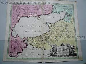
Liege-Maastricht-Brusselles, anno 1740, map by Seutter Matthäus
Publicado por Seutter Matthäus, 1678 - 1757, 1757
Librería: Hammelburger Antiquariat, Hammelburg, Alemania
Calificación del vendedor: 5 de 5 estrellas

EUR 100,00
EUR 30,00 shipping
Ships from Alemania to Estados Unidos de AmericaCantidad disponible: 1 disponibles
Ańadir al carritoHardcover. Condición: very good. Liege-Maastricht-Brusselles, anno 1740, map by Seutter Matthäus SEUTTER, G.M. - L'Eveche et L'Etat de Liege Avec les appartenances designées dans les pais voisins Delineation nouvelle et exacte Aux depens de Matthieu Seutter. Augsburg, 1740. 49 x 61 cm. Contemporary colours Beautiful cooper engraved map of the central part of Belgium and parts of the Netherlands by M. Seutter. Showing the area around Ličge and Maastricht. The nice cartouche with two Belgium Lions. Printed on thick paper, only little stained, with a small restoration on left margin. Please look the pictures.
-
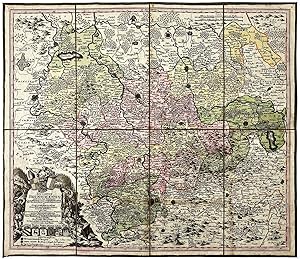
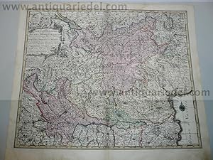
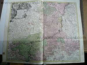
"Ducatus Brunsvicensis juxta tres suos Principatus Calenbergic, nimir et Grubenhagens." - Braunschweig Göttingen Hildesheim Hameln Wolfenbüttel Halberstadt Celle Wernigerode map Karte
Publicado por Augsburg, 1730
Idioma: Latín
Librería: Antiquariat Steffen Völkel GmbH, Seubersdorf, Alemania
Miembro de asociación: ILAB VDA
Calificación del vendedor: 5 de 5 estrellas
Mapa
EUR 69,99
EUR 30,00 shipping
Ships from Alemania to Estados Unidos de AmericaCantidad disponible: 1 disponibles
Ańadir al carritoOriginal altkolorierte Kupferstich-Karte von Matthäus Seutter (1678-1757) von ca. 1730. -- Blatt-Maße: ca. 60 x 53 cm. In 8 Segmenten auf Leinwand aufgezogen. -- gut erhalten. || Original old colored engraved map by Matthäus Seutter (1678-1757) from c. 1730. Mounted on linen. -- in good condition. // Wir, das Antiquariat Steffen Völkel, kaufen und verkaufen alte Bücher, Handschriften, Zeichnungen, Autographen, Grafiken und Fotografien. Wir sind stets am Ankauf von kompletten Bibliotheken, Sammlungen und Nachlässen interessiert. la Gewicht in Gramm: 50.
-

Brabantiae Ducatus, anno 1740, Seutter M. contemporary colours
Publicado por Seutter Matthäus, 1678 - 1757, 1757
Librería: Hammelburger Antiquariat, Hammelburg, Alemania
Calificación del vendedor: 5 de 5 estrellas
EUR 180,00
EUR 30,00 shipping
Ships from Alemania to Estados Unidos de AmericaCantidad disponible: 1 disponibles
Ańadir al carritoHardcover. Condición: Gut. Brabantiae Ducatus, anno 1740, Seutter M. contemporary colours Brabantiae Ducatus Cum Adjacentibus Provinciis studio et impensis Matthaei Seutteri, S. Caes. et Reg. Cathol. Majest. Geographi, Augustae Vindel. Size of the leaf: 53x60 cm., printed on thick paper in publishers colours, clean print, one small restoration on centerfold, not to see in front of the map.
-

Les Routes Exactes des Postes du Royaume de France - Matthäus Se
Publicado por Seutter Matthäus, 1678 - 1757, 1757
Librería: Hammelburger Antiquariat, Hammelburg, Alemania
Calificación del vendedor: 5 de 5 estrellas
EUR 200,00
EUR 30,00 shipping
Ships from Alemania to Estados Unidos de AmericaCantidad disponible: 1 disponibles
Ańadir al carritoHardcover. Condición: very good. Les Routes Exactes des Postes du Royaume de France - Matthäus Seutter ca 1740 Altkolorierter Kupferstich, Blatt: 61 x 54 cm, Darstellung: 57 x 45 cm. Dekorative altkolorierte Postkarte von Frankreich mit französischem Titel und Legende im Rand. Sehr schönes Altkolorit, gedruckt auf festem Papier. Hinterlegter Einriss, fachmännisch restauriert.
-

Paris with environs, streetmap, 1740, Seutter Matthäus
Publicado por Seutter Matthäus, 1678 - 1757, 1757
Librería: Hammelburger Antiquariat, Hammelburg, Alemania
Calificación del vendedor: 5 de 5 estrellas
EUR 200,00
EUR 30,00 shipping
Ships from Alemania to Estados Unidos de AmericaCantidad disponible: 1 disponibles
Ańadir al carritoHardcover. Condición: very good. Paris with environs, streetmap, 1740, Seutter Matthäus Carte de la Prevoste et Vicomte de Paris - DreBee fur ungrand nombre de Memoires particudiers aBujettis aux Observations de Mrs. d l Academie Rle des Sciences; Gravee par Matth. Seutter, S. C. et R. Cath. M. Geogr. a Augsbourg. Augsburg, Matthaeus Seutter 1740 - size of the leaf: 53x62 cm. Copper-engraving, handcolored in outline and wash , IN PUBLISHERS COLOURS. Decorative map by the famous cartographer Matthaeus Seutter showing the nearer district around Paris. Showing small place names, villages, casles, monastries, rivers, lakes, streets, etc. THE MAP IS IN EXCELLENT CONDITION, PRINTED ON THICK PAPER, NO CRACS.
-

DUCATUS CARNIOLAE VINDORUM MARCHIA ET HISTRIA
Publicado por ,, 1730
Librería: libreria minerva, Padova, PD, Italia
Calificación del vendedor: 4 de 5 estrellas

EUR 220,00
EUR 30,00 shipping
Ships from Italia to Estados Unidos de AmericaCantidad disponible: 1 disponibles
Ańadir al carritoCondición: Buono (Good). La carta č uno dei rifaciamenti della tavola "Tabula Ducatus Carniola, Vindorum Marchiae et Histriae" di Johann Baptiste Homann realizzata dopo il 1716. acquaforte acquerellata in epoca cm. 58 x 49.5 Buono (Good) Buon es. - piccoli strappi nel margine superiore. Book.
-

Asia,Generalmap,Seutter-Lotter,anno 1750,old colours
Publicado por Seutter Matthäus, 1678 - 1757, 1757
Librería: Hammelburger Antiquariat, Hammelburg, Alemania
Calificación del vendedor: 5 de 5 estrellas
EUR 290,00
EUR 30,00 shipping
Ships from Alemania to Estados Unidos de AmericaCantidad disponible: 1 disponibles
Ańadir al carritoHardcover. Condición: Gut. Copperengraving, edited by Seutter-Lotter, Augsburg, approx. anno 1750, full contemporary colours, little brownish, size of the leaf: 21 x 28 cm.
-
Scaniae,map,Seutter anno 1730, full coloured
Publicado por Seutter Matthäus, 1678 - 1757, 1730
Librería: Hammelburger Antiquariat, Hammelburg, Alemania
Calificación del vendedor: 5 de 5 estrellas
Mapa
EUR 300,00
EUR 30,00 shipping
Ships from Alemania to Estados Unidos de AmericaCantidad disponible: 1 disponibles
Ańadir al carritoHardcover. Condición: Gut. Coppermap, edited by Seutter Matthäus, anno 1730, size of the leaf: 53 x 62 cm., printed on thick paper, little brownish on margins. Small restauration on verso, in front not to see.
-

Graeciae pars Meridionalis, 1740, Seutter M., old colours; ed
Publicado por Seutter Matthäus, 1678 - 1757, 1757
Librería: Hammelburger Antiquariat, Hammelburg, Alemania
Calificación del vendedor: 5 de 5 estrellas
EUR 350,00
EUR 30,00 shipping
Ships from Alemania to Estados Unidos de AmericaCantidad disponible: 1 disponibles
Ańadir al carritoHardcover. Condición: Gut. Graeciae pars Meridionalis, 1740, Seutter M., old colours; edited by Matthäus Seutter, Augsburg. Comtemporary publishers colours, printed on thick paper, very good condition. Size of the leaf: 52x63 cm.
-
Scotia, anno 1740, map, Seutter M., original colours
Publicado por Seutter Matthäus, 1678 - 1757, 1757
Librería: Hammelburger Antiquariat, Hammelburg, Alemania
Calificación del vendedor: 5 de 5 estrellas
EUR 360,00
EUR 30,00 shipping
Ships from Alemania to Estados Unidos de AmericaCantidad disponible: 1 disponibles
Ańadir al carritoHardcover. Condición: Gut. Scotia, anno 1740, map, Seutter M., original colours SEUTTER,M. - Nova et accurata totius Regni Scotiae, Secundum Omnes Provincias et adjacentes Insulas., published in Augsburg 1740. Published : Augsburg 1740. Size: 57 x 49 cm. Very fine, original publishers colours, printed on thick paper, fine print. Fully and strongly engraved copper plate map that includes all of Scotland and the New Hebrides, here called the Western Iles of Scotland. The map is filled with minute detail and hundreds of place names. Embellished with two large and most decorative cartouches with figures, coat of arms, and a compass rose off the mouth of the Fyrth of Forth.
-

Italy Generalmap, Seutter Matthäus, a. 1720
Publicado por Seutter Matthäus, 1678 - 1757, 1720
Librería: Hammelburger Antiquariat, Hammelburg, Alemania
Calificación del vendedor: 5 de 5 estrellas
EUR 369,00
EUR 30,00 shipping
Ships from Alemania to Estados Unidos de AmericaCantidad disponible: 1 disponibles
Ańadir al carritoHardcover. Condición: Gut. Italy Generalmap, Seutter Matthäus, a. 1720 Generalmap, edited by Matthäus Seutter, anno 1720, contemporary coloured, Size of the leaf: 53 x 62 cm., printed on thick paper, on upper margin little waterstained, not to see. very scarce map of Italy.
-

Nordeuropa, Schweden, Ostsee, anno 1740, Seutter M., altkolorier
Publicado por Seutter Matthäus, 1678 - 1757, 1757
Librería: Hammelburger Antiquariat, Hammelburg, Alemania
Calificación del vendedor: 5 de 5 estrellas
EUR 370,00
EUR 30,00 shipping
Ships from Alemania to Estados Unidos de AmericaCantidad disponible: 1 disponibles
Ańadir al carritoHardcover. Condición: very good. Nordeuropa, Schweden, Ostsee, anno 1740, Seutter M., altkoloriert Nova mappa geographica Sueciae ac Gothiae Regna ut et Finlandiae Ducatum ac Lapponiam, cum provinciis minoribus Seutter, Mathias, 1740 "Nova mappa geographica Sueciae ac Gothiae Regna ut et Finlandiae Ducatum ac Lapponiam, cum provinciis minoribus". Altkol. Kupf.-Kte. von M. Seutter, um 1740. Mit fig. u. herald. Kart. 49,5:57,5 cm., Blatt: 53x62 cm., gedruckt auf festem Papier, sehr schönes zeitgenössisches Kolorit, etwas fingerfleckig, an den Rändern von hinten verstärkt.
-

NOVA ET EXACTISSIMA TOTIUS ITALIAE SARDINIAE ET CORSICAE DELINEATIO OPERA ET IMPENSIS
Publicado por Augusta, 1730 ca., Augusta, 1730
Librería: libreria minerva, Padova, PD, Italia
Calificación del vendedor: 4 de 5 estrellas
EUR 380,00
EUR 30,00 shipping
Ships from Italia to Estados Unidos de AmericaCantidad disponible: 1 disponibles
Ańadir al carritoCondición: Buono (Good). acquaforte acquerellata a mano inciso cm. 57 x 48 - foglio cm. 60,5 x 52,6 Buono (Good) Buon es. Book.
-
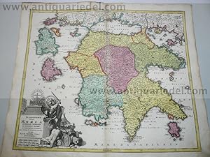
Morea,Peloponnes,map, Seutter,anno 1730
Publicado por Seutter Matthäus, 1678 - 1757, 1757
Librería: Hammelburger Antiquariat, Hammelburg, Alemania
Calificación del vendedor: 5 de 5 estrellas
EUR 390,00
EUR 30,00 shipping
Ships from Alemania to Estados Unidos de AmericaCantidad disponible: 1 disponibles
Ańadir al carritoHardcover. Condición: Gut. Morea,Peloponnes,map, Seutter,anno 1730 Coppermap, edited by Matthäus Seutter, anno 1730, size of the leaf 53 x 62 cm., nice, contemporary coloured. little brownish on margins, upper margin little waterstained.
-
Mediolanensis,Venetia,map,Seutter anno 1720,old coloured
Publicado por Seutter Matthäus, 1678 - 1757, 1757
Librería: Hammelburger Antiquariat, Hammelburg, Alemania
Calificación del vendedor: 5 de 5 estrellas
EUR 390,00
EUR 30,00 shipping
Ships from Alemania to Estados Unidos de AmericaCantidad disponible: 1 disponibles
Ańadir al carritoHardcover. Condición: Gut. Original coppermap, edited by Matthäus Seutter, anno 1720, printed on thick paper, contemporary full coloured, very good condition, no cracs or tears, centerfold ok., little brownish on margins. To see northern Italy with the italian lakes and Venetia. Below margins: Parma, Modena, Bologna.
-
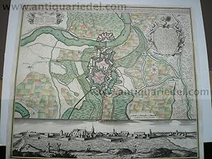
Philippsburg, anno 1730, Seutter Matthäus
Publicado por Seutter Matthäus, 1678 - 1757, 1757
Librería: Hammelburger Antiquariat, Hammelburg, Alemania
Calificación del vendedor: 5 de 5 estrellas
EUR 390,00
EUR 30,00 shipping
Ships from Alemania to Estados Unidos de AmericaCantidad disponible: 1 disponibles
Ańadir al carritoHardcover. Condición: Gut. Philippsburg, anno 1730, Seutter Matthäus, Blattmaß: 51x60 cm.
-
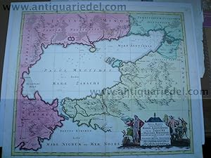
Black Sea,map,Seutter,anno 1730, contemporary coloured Coppermap
Publicado por Seutter Matthäus, 1678 - 1757, 1730
Librería: Hammelburger Antiquariat, Hammelburg, Alemania
Calificación del vendedor: 5 de 5 estrellas
Mapa
EUR 399,00
EUR 30,00 shipping
Ships from Alemania to Estados Unidos de AmericaCantidad disponible: 1 disponibles
Ańadir al carritoHardcover. Condición: Gut. Black Sea,map,Seutter,anno 1730, contemporary coloured Coppermap, edited by Matthäus Seutter, Germany, anno 1730, contemporary coloured, printed on thick paper, little brownish, size of the leaf: 53 x 64 cm., Detailled map of the northern part of the black Sea, Krim, etc. "NOVA MAPPA GEOGRAPHICA MARIS ASSOVIENSIS VEL DE ZABACHE ET PALUDIS MAEOTIDIS, accurate aeri incisa et in huce edita per MATTHAEUM SEUTTER CHAICOGRAPH.".
-

Frankfurt mit Umgebung, anno 1740, Seutter Matthäus 'Territoriu
Publicado por Seutter Matthäus, 1678 - 1757, 1757
Librería: Hammelburger Antiquariat, Hammelburg, Alemania
Calificación del vendedor: 5 de 5 estrellas
EUR 400,00
EUR 30,00 shipping
Ships from Alemania to Estados Unidos de AmericaCantidad disponible: 1 disponibles
Ańadir al carritoHardcover. Condición: Gut. Frankfurt mit Umgebung, anno 1740, Seutter Matthäus 'Territorium Sac. Rom. Imp. Lib. Civitatis Francofurti Ad Moenum cum magna parte Archiepiscopatus Moguntini, Comitatus Hanoviensis aliarumq regionum finitimarum, accuratissime delineavit Matthaeus Seutter, Sac. Caes. Maj. Geogr. Aug. Vind. C.Gr. et Pr. S.R.I. Vicar in part Rheni Sveviae et Juris Franconici. Zeigt den Großraum Frankfurt mit dem Mainlauf von Hanau bis Kelsterbach. - Frankfurt, Hanau und Höchst mit Befestigungsplänen. Im Südosten noch mit Babenhausen; im Nordwesten mit Kronberg, Oberursel, Bad Homburg. - Unten links Titelkartusche mit Allegorien und Wappen. Blattmaß: 53x60 cm., sehr schönes Verlagskolorit, an den Rändern etwas gebräunt.
-
Regnum Hiberniae, anno 1740, map, Seutter Matthäus
Publicado por Seutter Matthäus, 1678 - 1757, 1757
Librería: Hammelburger Antiquariat, Hammelburg, Alemania
Calificación del vendedor: 5 de 5 estrellas
EUR 400,00
EUR 30,00 shipping
Ships from Alemania to Estados Unidos de AmericaCantidad disponible: 1 disponibles
Ańadir al carritoHardcover. Condición: Gut. "Regnum Hiberniae, anno 1740, map, Seutter Matthäus "Regnum Hiberniae, tam Secundum IV Provincias Principales Ultoniam, Connaciam, Lageniam, Momoniam" The title cartouche supports the royal British arms and the large pictorial cartouche at bottom presents a bucolic scene of Mercury with herdsmen, shepherds and fishermen and supports the Irish coat of arms. Printed in original publishers colours, printed on thick paper, good condition, two small restorations on centerfold. Size of the leaf: 53x63 cm.".
-
Bavaria Superior et Inferior, 1740, Seutter M., altkoloriert
Publicado por Seutter Matthäus, 1678 - 1757, 1757
Librería: Hammelburger Antiquariat, Hammelburg, Alemania
Calificación del vendedor: 5 de 5 estrellas
EUR 420,00
EUR 30,00 shipping
Ships from Alemania to Estados Unidos de AmericaCantidad disponible: 1 disponibles
Ańadir al carritoHardcover. Condición: Gut. Bavaria Superior et Inferior, 1740, Seutter M., altkoloriert Bavaria Superior et Inferior cum Quatuor Praefecturis juxta recentissimam Designationem ob oculus posita per Matthaeum Seutter, Sac. Caes. et Cathol. Reg. Majest. Geographum Augustae Vindel. Blattmaß: 53x62 cm., gedruckt auf dickem Papier, in Verlagskolorit der Zeit,bis auf ein kleines hinterlegtes Löchleinausgezeichneter Erhaltungszustand.
-
Italiae antique item Insularum, 1740, Seutter M., old colours
Publicado por Seutter Matthäus, 1678 - 1757, 1757
Librería: Hammelburger Antiquariat, Hammelburg, Alemania
Calificación del vendedor: 5 de 5 estrellas
EUR 450,00
EUR 30,00 shipping
Ships from Alemania to Estados Unidos de AmericaCantidad disponible: 1 disponibles
Ańadir al carritoHardcover. Condición: Gut. Italiae antique item Insularum, 1740, Seutter M., old colours Italić antique item insularum Sicilić, Sardinić, Corsicć, typus et nova delineatio ; cum gratia et privil. S. R. I. vicariat[us], in partib[us] Rheni, Svević, et juris Franconici ; ćri insculpta per Matthćum Seutter, S. cćs. et reg. Italien ; Geschichte Altertum Title: Italić antique item insularum Sicilić, Sardinić, Corsicć, typus et nova delineatio ; Kartenmaterial ; cum gratia et privil. S. R. I. vicariat[us], in partib[us] Rheni, Svević, et juris Franconici ; ćri insculpta per Matthćum Seutter, S. cćs. et reg. cathol. Majest. geographum Size of the leaf: 52x63 cm., in original publishers colours, little brownish. Scarce map.
-
Augsburg, Panorama+Karte, anno 1730, Seutter M., selten verlegt
Publicado por Seutter Matthäus, 1678 - 1757, 1757
Librería: Hammelburger Antiquariat, Hammelburg, Alemania
Calificación del vendedor: 5 de 5 estrellas
EUR 450,00
EUR 30,00 shipping
Ships from Alemania to Estados Unidos de AmericaCantidad disponible: 1 disponibles
Ańadir al carritoHardcover. Condición: Gut. Augsburg, Panorama+Karte, anno 1730, Seutter M., selten verlegt bei Seutter M., in Augsburg, ca. 1730: "Prospect deß Heil. Röm. Reichs freyen Stadt Augsburg wie solche von morgen her anzusehen. -Kopftitel: Augspurg die Haupt-Stadt und Zierde des Schwäbischen Craises, samt der umliegenden Gegend." Sehr guter Erhaltungszustand, gedruckt auf dickem Papier, altkoloriert. Blattmaß: 50x60 cm Referenz: Fauser, Nr. 882. Sehr schönes, kräftiges Kolorit, gedruckt auf dickem Papier, einige Reparaturen am Fuß, kleiner Feuchtigkeitsfleck.
-
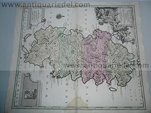
Sardinia, Isle, anno 1730, Seutter Matthäus, scarce map
Publicado por Seutter Matthäus, 1678 - 1757, 1757
Librería: Hammelburger Antiquariat, Hammelburg, Alemania
Calificación del vendedor: 5 de 5 estrellas
EUR 490,00
EUR 30,00 shipping
Ships from Alemania to Estados Unidos de AmericaCantidad disponible: 1 disponibles
Ańadir al carritoHardcover. Condición: Gut. Sardinia, Isle, anno 1730, Seutter Matthäus, scarce map Coppermap, edited by Matthäus Seutter, anno 1730, contemporary full coloured, printed on thick paper, little waterstained on centerfold. Size of the leaf: 53 x 62 cm., very scarce map of the isle Sardinia.
-
Black Sea,map,Seutter,anno 1730, contemporary coloured
Publicado por Seutter Matthäus, 1678 - 1757, 1757
Librería: Hammelburger Antiquariat, Hammelburg, Alemania
Calificación del vendedor: 5 de 5 estrellas
EUR 490,00
EUR 30,00 shipping
Ships from Alemania to Estados Unidos de AmericaCantidad disponible: 1 disponibles
Ańadir al carritoHardcover. Condición: Gut. Black Sea,map,Seutter,anno 1730, contemporary coloured Coppermap, edited by Matthäus Seutter, Germany, anno 1730, contemporary coloured, printed on thick paper, little brownish, size of the leaf: 53 x 64 cm., Detailled map of the northern part of the black Sea, Krim, etc. "NOVA MAPPA GEOGRAPHICA MARIS ASSOVIENSIS VEL DE ZABACHE ET PALUDIS MAEOTIDIS, accurate aeri incisa et in huce edita per MATTHAEUM SEUTTER CHAICOGRAPH.".
-
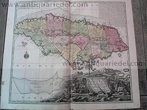
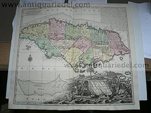
Jamaica-anno 1740, map Seutter Matthäus, old colours
Publicado por Seutter Matthäus, 1678 - 1757, 1757
Librería: Hammelburger Antiquariat, Hammelburg, Alemania
Calificación del vendedor: 5 de 5 estrellas
EUR 500,00
EUR 30,00 shipping
Ships from Alemania to Estados Unidos de AmericaCantidad disponible: 1 disponibles
Ańadir al carritoHardcover. Condición: very good. Jamaica-anno 1740, map Seutter Matthäus, old colours NOVA DESIGNATIO INSULA JAMAICAE EX ANTILLIANIS AMERICAE SEPTENTRION, G. M. Seutter., Augsburg. A handsome map of the island of Jamaica by a premier 18th century mapmaker, Mathias Seutter (1678-1756). The map shows Jamaica divided into precincts and details topographical features of mountains, forests, rivers & small settlements. Around the coasts the map indicates harbors, bays with depth soundings, shoals & small offshore islands. Size of the leaf: 53x62 cm., printed on thick paper, no cracs, publishers colours.
-
Jamaica-anno 1740, map Seutter Matthäus, old colours NOVA DESIGN
Publicado por Seutter Matthäus, 1678 - 1757, 1757
Librería: Hammelburger Antiquariat, Hammelburg, Alemania
Calificación del vendedor: 5 de 5 estrellas
EUR 550,00
EUR 30,00 shipping
Ships from Alemania to Estados Unidos de AmericaCantidad disponible: 1 disponibles
Ańadir al carritoHardcover. Condición: Gut. Jamaica-anno 1740, map Seutter Matthäus, old colours NOVA DESIGNATIO INSULA JAMAICAE EX ANTILLIANIS AMERICAE SEPTENTRION, G. M. Seutter., Augsburg. A handsome map of the island of Jamaica by a premier 18th century mapmaker, Mathias Seutter (1678-1756). The map shows Jamaica divided into precincts and details topographical features of mountains, forests, rivers & small settlements. Around the coasts the map indicates harbors, bays with depth soundings, shoals & small offshore islands. Size of the leaf: 53x62 cm., printed on thick paper, no cracs, publishers colours.
-
Ulm, anno 1740, Plan+Panorama, Seutter M., altkoloriert, selten
Publicado por Seutter Matthäus, 1678 - 1757, 1757
Librería: Hammelburger Antiquariat, Hammelburg, Alemania
Calificación del vendedor: 5 de 5 estrellas
EUR 800,00
EUR 30,00 shipping
Ships from Alemania to Estados Unidos de AmericaCantidad disponible: 1 disponibles
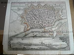
Ańadir al carritoHardcover. Condición: Gut. Ulm, anno 1740, Plan+Panorama, Seutter M., altkoloriert, selten "Ulma memorabilis ac permunita libera Imperii Civitas ad Danubium,." ".Ulm eine considerable Freye Reichs Statt in Schwabnen,." Verlegt von Seutter Matthäus, Augsburg, ca. anno 1740, Platte: 485x565 mm., Blatt: 570x650 mm., altkoloriert, etwas stockfleckig, div. rest. Randläsuren. Referenz: Fauser, Nr. 14 452.
-
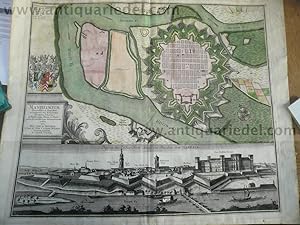
Mannheim, anno 1740, Seutter
Publicado por Seutter Matthäus, 1678 - 1757, 1757
Librería: Hammelburger Antiquariat, Hammelburg, Alemania
Calificación del vendedor: 5 de 5 estrellas
EUR 600,00
EUR 30,00 shipping
Ships from Alemania to Estados Unidos de AmericaCantidad disponible: 1 disponibles
Ańadir al carritoHardcover. Condición: Gut. Mannheim, anno 1740, Seutter Mannheim. Manheimium, Plan, darunter Gesamtansicht. Kupferstich, der Plan koloriert, von M. Seutter, um 1740. Plattengröße ca. 49,5 x 58 cm, Blattgröße ca. 53,5 x 65 cm. Altersspuren, im Passepartoutausschnitt leicht lichtrandig und gebräunt, stellenweise etwas feuchtfleckig, verso beschriftet und aquarelliert.
-
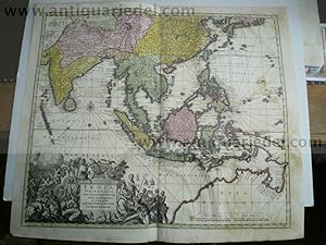
India orientalis,map,Seutter,anno 1740,with Australia Coppermap,
Publicado por Seutter Matthäus, 1678 - 1757, 1757
Librería: Hammelburger Antiquariat, Hammelburg, Alemania
Calificación del vendedor: 5 de 5 estrellas
EUR 850,00
EUR 30,00 shipping
Ships from Alemania to Estados Unidos de AmericaCantidad disponible: 1 disponibles
Ańadir al carritoHardcover. Condición: Gut. India orientalis,map,Seutter,anno 1740,with Australia Coppermap, edited by Matthäus Seutter: "INDIA ORIENTALIS,CUM ADJACENTIBUS INSULIS NOVA DELINEATIONE ob oculos posita PER MATTHAEUM SEUTTER, S.C.M.GEOGR.AUGUST." Size of the leaf: 53 x 62 cm., of the map: 46 x 55 cm., contemporary full coloured, printed on thick paper, little restorations on below centerfold, the map is a little waterstained, small restored wormhole. Please look the pictures. Map of East Indies with Japan and Australia. To see Japan and Persia in the North, the Maldives in the West, Australia in the south. Australia called Nova Hollandia.
-
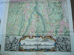
Praha/Praque/Prag, anno 1740, map, Seutter Matthäus, old colours
Publicado por Seutter Matthäus, 1678 - 1757, 1757
Librería: Hammelburger Antiquariat, Hammelburg, Alemania
Calificación del vendedor: 5 de 5 estrellas
EUR 700,00
EUR 30,00 shipping
Ships from Alemania to Estados Unidos de AmericaCantidad disponible: 1 disponibles
Ańadir al carritoHardcover. Condición: Gut. Praha/Praque/Prag, anno 1740, map, Seutter Matthäus, old colours Pragae Metropolis regni Bohemiae cum adjacentibus terris accurata descriptio geographica cura et studio Matth. Seutter. S. C. M. Geogr. Aug. Vindel. Map of Prague, environs of Bohemia, Prague Region, Czech Republic Cartographer Seutter, Matthaeus (1678-1756) Date Original circa 1740 Place of Publication Augsburg Dimensions 50 x 57 cm. Very good condition, in contemporary colours.