
Importe total (1 artĒculo artĒculos):
Destino del pedido:

neele samuel (67 resultados)
Comentarios
Ir a los resultados principales
Filtros de b·squeda
Tipo de artĒculo
- Todos los tipos de productos
- Libros (43)
- Revistas y publicaciones (No hay ning·n otro resultado que coincida con este filtro.)
- C¾mics (No hay ning·n otro resultado que coincida con este filtro.)
- Partituras (No hay ning·n otro resultado que coincida con este filtro.)
- Arte, grabados y p¾sters (1)
- FotografĒas (No hay ning·n otro resultado que coincida con este filtro.)
- Mapas (22)
- Manuscritos y coleccionismo de papel (1)
Condici¾n Mßs informaci¾n
Encuadernaci¾n
Mßs atributos
- Primera edici¾n (10)
- Firmado (3)
- Sobrecubierta (No hay ning·n otro resultado que coincida con este filtro.)
- Con imßgenes (55)
- No impresi¾n bajo demanda (46)
Idioma (2)
Gastos de envĒo gratis
Ubicaci¾n del vendedor
Valoraci¾n de los vendedores
-

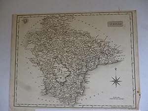
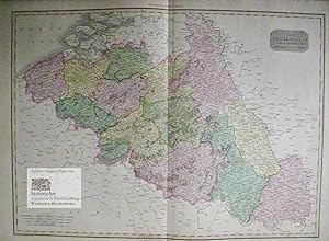
Map of Austria; 1810
Publicado por John Wilkes, London, 1810
Librería: Antiquarius Booksellers, Falkland, BC, Canada
Calificaci¾n del vendedor: 4 de 5 estrellas

Mapa
EUR 15,55
Convertir monedaEUR 12,94 gastos de envĒo desde Canada a Espa±aCantidad disponible: 1 disponibles
A±adir al carritoNo Binding. Condici¾n: Very Good. Samuel Neele, Engraver Ilustrador. Antique Copper Engraved Map of Austria, circa 1810. Black and white, as published, no colour. At foot of map is stated - 'Pubd. as the Act directs 31 March 1810 by J. Wilkes'. Size of map within heavy black borders is 23.5 cm by 19 cm. Clean white, thick paper, a very little, light foxing along some edges. Adequate margins for matting. We ship worldwide by mail at cost. Size: 27cm by 20cm. Map.
-
Durham [County in England]; 1803 Map
Publicado por John Wilkes, London, 1803
Librería: Antiquarius Booksellers, Falkland, BC, Canada
Calificaci¾n del vendedor: 4 de 5 estrellas
Mapa
EUR 17,77
Convertir monedaEUR 12,94 gastos de envĒo desde Canada a Espa±aCantidad disponible: 1 disponibles
A±adir al carritoNo Binding. Condici¾n: Very Good. Samuel Neele, Engraver Ilustrador. Antique Copper Engraved Map of County Durham, England dated 1803. Black and white, as published, no colour. At foot of map is stated - 'London Published as the Act directs, April 16, 1803 by J. Wilkes'. Engraved by Samuel Neele. Size of map within heavy black borders is 23.3 cm by 18.8 cm. Clean white, thick paper. Some faint foxing to margins only. Adequate margins for matting. We ship worldwide by mail at cost. Size: 27cm by 20cm. Map.
-
Russia in Europe; 1826
Publicado por John Wilkes, London, 1826
Librería: Antiquarius Booksellers, Falkland, BC, Canada
Calificaci¾n del vendedor: 4 de 5 estrellas
Mapa
EUR 22,21
Convertir monedaEUR 12,94 gastos de envĒo desde Canada a Espa±aCantidad disponible: 1 disponibles
A±adir al carritoNo Binding. Condici¾n: Very Good. Samuel Neele, Engraver Ilustrador. Antique Copper Engraved Map of Russia in Europe dated 1826. Gulf of Finland to the Ural Mountains - Lapland south to the Crimea. Black and white, as published, no colour. At foot of map is stated - 'Engraved for the 'Encyclopaedia Londinensis' [Wilkes], 1826'. Size of map within heavy black borders is 18.7 cm by 23.5 cm. Clean white, thick paper. No foxing. Adequate margins for matting. We ship worldwide by mail at cost. Size: 27cm by 20cm. Map.
-
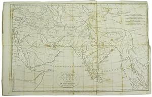
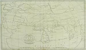
Map of Asia [Including Australia]; 1796
Publicado por John Wilkes, London, 1796
Librería: Antiquarius Booksellers, Falkland, BC, Canada
Calificaci¾n del vendedor: 4 de 5 estrellas
Mapa
EUR 26,66
Convertir monedaEUR 12,94 gastos de envĒo desde Canada a Espa±aCantidad disponible: 1 disponibles
A±adir al carritoNo Binding. Condici¾n: Very Good. Samuel Neele, Engraver Ilustrador. Antique Copper Engraved Map of Asia dated 1796. Includes Australia then known as New Holland, and the entire Indian Ocean. Black and white, as published, no colour. At foot of map is stated - 'London Pubd. as the Act directs August 13, 1796 by J. Wilk[e]s'. Size of map within heavy black borders is 18.3 cm by 23 cm. Clean white, thick paper, a very little, light foxing along some edges - none on map. Adequate margins for matting. We ship worldwide by mail at cost. Size: 27cm by 20cm. Map.
-
Devon
A±o de publicaci¾n: 1812
Idioma: Inglķs
Librería: Roger Collicott Books, Widecombe in the Moor, DEVON, Reino Unido
Calificaci¾n del vendedor: 4 de 5 estrellas
Mapa
EUR 41,29
Convertir monedaEUR 12,54 gastos de envĒo desde Reino Unido a Espa±aCantidad disponible: 1 disponibles
A±adir al carritoMap. Condici¾n: Very Good. Uncoloured early nineteenth century map. Slightly age discoloured. Size : 245 x 190 mm. Batten and Bennett 79.1. They suggest 'loose sheet, probably from a part set'.
-
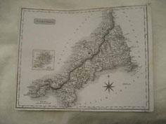
Cornwall
Idioma: Inglķs
Librería: Roger Collicott Books, Widecombe in the Moor, DEVON, Reino Unido
Calificaci¾n del vendedor: 4 de 5 estrellas
Mapa
EUR 41,29
Convertir monedaEUR 12,54 gastos de envĒo desde Reino Unido a Espa±aCantidad disponible: 1 disponibles
A±adir al carritoMap. Condici¾n: Near Fine. Probably from Dugdale's The New British Traveller. Scilly Islands are shown in an inset over the north coast.
-
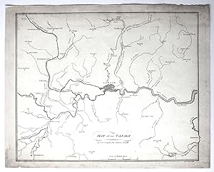
Map of the Canals (around London)
Publicado por John Stockdale, 1796
Librería: Morning Mist Books and Maps, Cirencester, Reino Unido
Calificaci¾n del vendedor: 5 de 5 estrellas

Mapa
EUR 11,80
Convertir monedaEUR 42,38 gastos de envĒo desde Reino Unido a Espa±aCantidad disponible: 1 disponibles
A±adir al carritoNo Binding. Condici¾n: Good. Uncoloured, outline map showing the rivers, tributaries and canals in and around London pre-1796. General spotting and toning, heavier to margins, both to front and to reverse. Edges scuffed. Only three canals marked: Basingstoke, Grand Junction, Paddington. Numerous rivers present but not all named. The map reaches as far as Guildford, Tring, Chelmsford, Tunbridge. Sheet size: 29.5cm by 23.3cm approx. 'Neele, Sculpt' to lower margin. Further details available on request. (non428cb).
-

Germany. North of the Mayne.
Publicado por EdinburghJohn Thomson. 1817, 1816
Librería: Robert Frew Ltd. ABA ILAB, London, Reino Unido
Miembro de asociaci¾n: ABA ILAB PBFA
Calificaci¾n del vendedor: 4 de 5 estrellas
Mapa
EUR 58,98
Convertir monedaEUR 7,44 gastos de envĒo desde Reino Unido a Espa±aCantidad disponible: 1 disponibles
A±adir al carrito50.3 x 60 cm. Original colour. Double page map. Browned overall. Split without loss at lower edge of centrefold.
-
Asia (1804)
A±o de publicaci¾n: 1804
Librería: Waimakariri Books and Prints Limited, Oxford, Nueva Zelanda
Calificaci¾n del vendedor: 3 de 5 estrellas

Mapa
EUR 49,94
Convertir monedaGratis gastos de envĒo desde Nueva Zelanda a Espa±aCantidad disponible: 1 disponibles
A±adir al carritoNo Binding. Condici¾n: Good. No Jacket. Small map of Asia, by Samuel Neele, published 1804. Page size 18.5 x 14 cm approx, two folds. Minor foxing and marks, slight creasing, slight tanning especially beside the fold, verso blank, tight upper margin. Free standard airmail worldwide. This does not include tracking, which is available at additional cost.
-
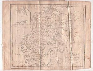
Map - Sweden, Norway and Denmark
Publicado por [1805], London, 1805
Librería: Renaissance Books, ANZAAB / ILAB, Dunedin, Nueva Zelanda
Miembro de asociaci¾n: ANZAAB ILAB
Calificaci¾n del vendedor: 5 de 5 estrellas
Mapa Original o primera edici¾n
EUR 39,98
Convertir monedaEUR 30,19 gastos de envĒo desde Nueva Zelanda a Espa±aCantidad disponible: 1 disponibles
A±adir al carritoMap. Condici¾n: Fair. Estado de la sobrecubierta: No Dust Jacket. First Edition. Two fold lines. Creasing. Loss along lower corner, with loss of the lower part of the word "London" from the engraver's information, but not affecting the printed map within the black border. A 3/8" tear to blank margin on right border. ; Map titled "Map of Sweden Norway and Denmark from the best Authorities". 260 x 210mm. Engraved by [Samuel] Neele. With inset map of East Greenland. This map is from William Guthrie's "A New Geographical, Historical, and Commercial Grammar and Present State of the Several Kingdoms of the World", eighteenth edition, Montrose: Printed by D. Buchanan, 1805. ; Map.
-

Map - Turkey in Europe with Hungary
Publicado por [1805], London, 1805
Librería: Renaissance Books, ANZAAB / ILAB, Dunedin, Nueva Zelanda
Miembro de asociaci¾n: ANZAAB ILAB
Calificaci¾n del vendedor: 5 de 5 estrellas
Mapa Original o primera edici¾n
EUR 39,98
Convertir monedaEUR 30,19 gastos de envĒo desde Nueva Zelanda a Espa±aCantidad disponible: 1 disponibles
A±adir al carritoMap. Condici¾n: Good. Estado de la sobrecubierta: No Dust Jacket. First Edition. Moderate foxing. Two fold lines.; Map titled "A Map of Turkey in Europe with Hungary from the best Authorities". Dimensions: 255 x 210mm. Engraved by Samuel Neele. This map is from William Guthrie's "A New Geographical, Historical, and Commercial Grammar and Present State of the Several Kingdoms of the World", eighteenth edition, Montrose: Printed by D. Buchanan, 1805. ; Map.
-
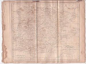
Map - Spain and Portugal
Publicado por [1805], London, 1805
Librería: Renaissance Books, ANZAAB / ILAB, Dunedin, Nueva Zelanda
Miembro de asociaci¾n: ANZAAB ILAB
Calificaci¾n del vendedor: 5 de 5 estrellas
Mapa Original o primera edici¾n
EUR 39,98
Convertir monedaEUR 30,19 gastos de envĒo desde Nueva Zelanda a Espa±aCantidad disponible: 1 disponibles
A±adir al carritoMap. Condici¾n: Fair. Estado de la sobrecubierta: No Dust Jacket. First Edition. Moderate foxing. Some heavy foxing to inner blank margin. Two areas of staining to upper blank margin. Small 3/8" chip to upper blank margin. Two fold lines.; Map titled "A Map of Spain & Portugal from the best Authorities". Dimensions: 265 x 210mm. Engraved by Samuel Neele. This map is from William Guthrie's "A New Geographical, Historical, and Commercial Grammar and Present State of the Several Kingdoms of the World", eighteenth edition, Montrose: Printed by D. Buchanan, 1805. ; Map.
-
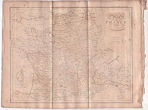
Map - France
Publicado por [1805], London, 1805
Librería: Renaissance Books, ANZAAB / ILAB, Dunedin, Nueva Zelanda
Miembro de asociaci¾n: ANZAAB ILAB
Calificaci¾n del vendedor: 5 de 5 estrellas
Mapa Original o primera edici¾n
EUR 39,98
Convertir monedaEUR 30,19 gastos de envĒo desde Nueva Zelanda a Espa±aCantidad disponible: 1 disponibles
A±adir al carritoMap. Condici¾n: Good. Estado de la sobrecubierta: No Dust Jacket. First Edition. Quite heavy foxing. Two fold lines. ; Map titled "Map of France with its late Acquisitions". Dimensions: 270 x 210mm. With an inset map of Corsica. Engraved by [Samuel] Neele. This map is from William Guthrie's "A New Geographical, Historical, and Commercial Grammar and Present State of the Several Kingdoms of the World", eighteenth edition, Montrose: Printed by D. Buchanan, 1805. ; Map.
-

Map - England and Wales
Publicado por [c1801-1805], London, 1801
Librería: Renaissance Books, ANZAAB / ILAB, Dunedin, Nueva Zelanda
Miembro de asociaci¾n: ANZAAB ILAB
Calificaci¾n del vendedor: 5 de 5 estrellas
Mapa Original o primera edici¾n
EUR 39,98
Convertir monedaEUR 30,19 gastos de envĒo desde Nueva Zelanda a Espa±aCantidad disponible: 1 disponibles
A±adir al carritoMap. Condici¾n: Good. Estado de la sobrecubierta: No Dust Jacket. First Edition. Quite heavy foxing. Two fold lines. ; Map titled "Map of England & Wales from the best Authorities 1801". Dimensions: 260 x 210mm. Engraved by [Samuel] Neele. This map is from William Guthrie's "A New Geographical, Historical, and Commercial Grammar and Present State of the Several Kingdoms of the World", eighteenth edition, Montrose: Printed by D. Buchanan, 1805. ; Map.
-

An Interesting Letter to a Mr Dodds from the Engraver Samuel John Neele With Regards to Copper Plates for Probably a Book on The Battle of Waterloo.
Publicado por UK, 1816
Librería: Lasting Words Ltd, Northampton, UK, Reino Unido
Miembro de asociaci¾n: PBFA
Calificaci¾n del vendedor: 5 de 5 estrellas
Manuscrito Original o primera edici¾n Ejemplar firmado
EUR 117,97
Convertir monedaEUR 15,98 gastos de envĒo desde Reino Unido a Espa±aCantidad disponible: 1 disponibles
A±adir al carritoPaper. Condici¾n: Good. First Edition. An Interesting Letter to a Mr Dodds from the Engraver Samuel John Neele With Regards to Copper Plates for Probably a Book on The Battle of Waterloo. Dated 1816. Samuel John Neele (1758-1824) was an important British engraver and cartographer who is known to have produced a substantial body of work including both maps and portraits. He operated a print shop in London with his sons between 1782 and 1833. From a autograph book kept by A. P. Watt (1834-1914), founder of A. P. Watt & Son in 1875, the world's first literary agents. Size is 170m x 105mm. Condition is good. Light folding creases. More images can be taken upon request. Ref18423. Signed by Author(s).
-
Map of the South East part of Asia for illustrating Dr. Robertson's Historical Disquisition &c
Publicado por Published as the Act directs. By T. Cadell Strand, London, 1791
Librería: Kaaterskill Books, ABAA/ILAB, East Jewett, NY, Estados Unidos de America
Miembro de asociaci¾n: ABAA ILAB IOBA
Calificaci¾n del vendedor: 5 de 5 estrellas
EUR 44,43
Convertir monedaEUR 32,78 gastos de envĒo desde Estados Unidos de America a Espa±aCantidad disponible: 1 disponibles
A±adir al carrito35 x 55 cm. Removed from: Robertson, William, Historical Disquisition concerning the knowledge which the ancients had of India. A good copy, a few repaired tears and a few extra folds, some occasional foxing.
-

Hispania Romana.
Publicado por Longman,, [London]:, 1806
Librería: Nicholas D. Riccio Rare Books, ABAA, Florham Park, NJ, Estados Unidos de America
Miembro de asociaci¾n: ABAA ILAB
Calificaci¾n del vendedor: 4 de 5 estrellas
EUR 44,43
Convertir monedaEUR 34,51 gastos de envĒo desde Estados Unidos de America a Espa±aCantidad disponible: 1 disponibles
A±adir al carritoEngraved black and white map, 10" x 16". Center fold, 1/2" margins, small archival tap repair at bottom margin, slight aging and toning; otherwise very good. A very nice impression. A map of Spain from the Roman period. Provides the Roman names for the regions, and illustrates important topographical features.
-
Atlas to the Memoirs of John Duke of Marlborough; Containing Armorial Bearings, Fac Similes, Maps, and Military Plans.
Publicado por Longman, Hurst, Rees, Orme and Brown, London, 1820
Librería: Jeffrey H. Marks, Rare Books, ABAA, Rochester, NY, Estados Unidos de America
Miembro de asociaci¾n: ABAA ILAB
Calificaci¾n del vendedor: 5 de 5 estrellas
EUR 133,28
Convertir monedaEUR 31,06 gastos de envĒo desde Estados Unidos de America a Espa±aCantidad disponible: 1 disponibles
A±adir al carritoTitle leaf and three leaves of text. Engraved armorial bearings, facsimile letters, and engraved maps and plans including four full-page,ten folding maps plus two folding maps with overlays. 4to, later quarter calf and marbled boards. First edition. One of the folding is over 50& defective; and there is a neat marginal repair to another map.
-
Atlas to the Memoirs of John Duke of Marlborough; containing Armorial Bearings, Fac Similes, Maps, and Military Plans
Publicado por London: Printed for Longman, Hurst, Rees, Orme, and Brown, 1820, 1820
Librería: Adrian Harrington Ltd, PBFA, ABA, ILAB, Royal Tunbridge Wells, KENT, Reino Unido
Miembro de asociaci¾n: ABA ILAB PBFA
Calificaci¾n del vendedor: 5 de 5 estrellas
Original o primera edici¾n
EUR 348,00
Convertir monedaEUR 17,18 gastos de envĒo desde Reino Unido a Espa±aCantidad disponible: 1 disponibles
A±adir al carrito[War of the Spanish Succession] FIRST EDITION. Quarto (28 x 22cm), unpaginated. Containing 22 engraved maps, plans, facsimile letters, and armorial bearings. Contemporary tan half calf, with gilt titles to spine and marbled paper over boards. Turquoise endpapers. Internally crisp and clean, with a touch of light spotting and toning. Heavy wear to binding extremities, with loss to head and tail caps, and split joints. Tapes mostly holding, but very weak. Good.
-
Travels to the source of the Missouri River and across the American continent to the Pacific Ocean : performed by order of the Government of the United States, in the years 1804, 1805, and 1806. By Capitains Lewis and Clarke. Published from the official report, and illustrated by a map of the route, and other maps. First edition.
Publicado por London: Printed For Longman, Hurst , Rees, Orme and Brown., Paternoster-Row, 1814, 1814
Librería: Wittenborn Art Books, San Francisco, CA, Estados Unidos de America
Calificaci¾n del vendedor: 5 de 5 estrellas
Original o primera edici¾n
EUR 10.884,52
Convertir monedaEUR 15,53 gastos de envĒo desde Estados Unidos de America a Espa±aCantidad disponible: 1 disponibles
A±adir al carritoCondici¾n: Good. 4to. 22.5 x 29cm. xxiv, 663 , [1] pages; 4 map plates hors texte (one large folding). Page [664} is the publisher's catalogue .Contemporary boards with later linen spine and label; endpapers renewed, some offsetting present on map and plates, 2 leaves with closed tear.OCLC Number / Unique Identifier:4910831; Wright Howes, 317; Field 929; Howes L-317; Literature of Lewis & Clark 5A.2; Streeter 3128;.The controversial Louisiana Purchase in 1803 - whereby the United States purchased the territory of Louisiana (comprising a stretch of land from today's Montana to Louisiana with Colorado to the West and Missouri to the East) from the French - nearly doubled the size of the country. The cost of the transaction was $15,000,000, around $18 per square mile. Control of the entire area was taken over by the United States, including large areas of the country which was inhabited - and managed - by Native Americans, who had never themselves ceded the land. Following the Purchase, President Thomas Jefferson commissioned an expedition to explore the territory and report back in as much detail as possible. A primary aim was to find a new travel route across the country, ensuring an American presence in the area before other colonial powers took advantage of the area and tried to establish their own footholds. The Lewis and Clark Expedition - alternatively known as the Corps of Discovery Expedition - set out from Camp Dubois on the 14th May 1804, crossing the Continental Divide, eventually reaching St. Louis, Missouri, in 1806. They were famously assisted in interpretation and interactions with local tribes by Sacagawea, a Lemni Shoshone woman who accompanied the expedition.The Lewis and Clark Expedition introduced the United States government to various Native American tribes and how trade with them could be promoted, alongside advising on the viability of the path they followed. Various botanical and zoological specimens were returned to the East Coast, including corn, or maize, grown by Thomas Jefferson at Monticello. It took nearly 10 years for Lewis and Clark to publish their journals, first in Philadelphia in octavo format in 1814 as History of the Expedition under the Command of Captain Lewis and Clark, to the Sources of the Missouri, thence across the Rocky Mountains and down the River Colombia to the Pacific Ocean. Here we find the first British edition, including Neele's highly important folding map, showing the expedition route.
-
Autograph Note in the third person, "S.Neele presents his respects .", to Messrs. Cadell & Davies, sending [not present] "his two years General Account in which no plate is charged that has not actually been delivered" and listing the maps still in preparation.
Publicado por 4 x 6 inches, generally in good condition.
Librería: Julian Browning Rare Books & Manuscripts, London, Reino Unido
Calificaci¾n del vendedor: 4 de 5 estrellas
EUR 76,68
Convertir monedaEUR 11,45 gastos de envĒo desde Reino Unido a Espa±aCantidad disponible: 1 disponibles
A±adir al carritoStrand, 7 March 1810. Samuel John Neele (1758-1824), engraver, illustrator and mapmaker. The Neele family were prolific engravers who produced maps for many atlases and topographical works, including town plans. ". the following are in hand, & in a considerable state of forwardness: Spain & Portugal, Northn. U:States (these two will be finished in a few weeks, & with Southern Africa might form No. 4); The Caraccas; Germany, N. of the Marn; Austrian Territories; North Italy. &c &c.".
-
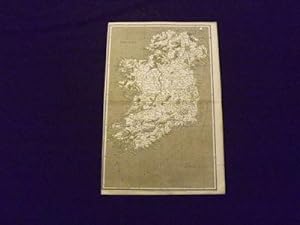
Ireland.
Publicado por Longman,, London:, 1808
Librería: Nicholas D. Riccio Rare Books, ABAA, Florham Park, NJ, Estados Unidos de America
Miembro de asociaci¾n: ABAA ILAB
Calificaci¾n del vendedor: 4 de 5 estrellas
EUR 57,75
Convertir monedaEUR 34,51 gastos de envĒo desde Estados Unidos de America a Espa±aCantidad disponible: 1 disponibles
A±adir al carritoEngraved black and white map, 10" x 16". Center fold, left margin almost at border, slight toning and aging; otherwise very good. Detailed black and white map of Ireland, illustrating the counties and important topographical features.
-
![Imagen del vendedor de A general collection of the ancient Irish music : containing a variety of admired airs never before published, and also the compositions of Conolan and Carolan 1796 [LeatherBound] a la venta por True World of Books](https://pictures.abebooks.com/inventory/md/md31534344451.jpg)
A general collection of the ancient Irish music : containing a variety of admired airs never before published, and also the compositions of Conolan and Carolan 1796 [LeatherBound]
A±o de publicaci¾n: 2025
Librería: True World of Books, Delhi, India
Calificaci¾n del vendedor: 5 de 5 estrellas
EUR 21,32
Convertir monedaGratis gastos de envĒo desde India a Espa±aCantidad disponible: 18 disponibles
A±adir al carritoLeatherBound. Condici¾n: New. LeatherBound edition. Condition: New. Reprinted from 1796 edition. Leather Binding on Spine and Corners with Golden leaf printing on spine. NO changes have been made to the original text. This is NOT a retyped or an ocr'd reprint. Illustrations, Index, if any, are included in black and white. Each page is checked manually before printing. Pages: 55 As this print on demand book is reprinted from a very old book, there could be some missing or flawed pages, but we always try to make the book as complete as possible. Fold-outs, if any, are not part of the book. If the original book was published in multiple volumes then this reprint is of only one volume, not the whole set. Sewing binding for longer life, where the book block is actually sewn (smythe sewn/section sewn) with thread before binding which results in a more durable type of binding. Pages: 55 Language: English.
-

A Map of the Countries Thirty Degrees Round the North Pole.
Publicado por London, 1796-. 350 x 350mm (13Š x 13Š inches)., 1796
Librería: Tooley, Adams & Co., Wallingford, OXON, Reino Unido
Calificaci¾n del vendedor: 5 de 5 estrellas
EUR 106,17
Convertir monedaEUR 4,70 gastos de envĒo desde Reino Unido a Espa±aCantidad disponible: 1 disponibles
A±adir al carritoUncoloured; expertly restored upper and lower margins with no loss of printed surface, light signs of old folds from the book, otherwise a fair example and priced accordingly. A map of the Arctic Circle and just over 6 degrees south. Show a fairly accurate map , although with the northen coast of North America and Greenland rather scetchy. Engraved by Samuel Neele, not sure of publication, but the paper has a dated watermark of 1796. Notes on the map refer to 'Dog Ribb'd Indians', 'Copper Indians' and 'Northern Indians'. And at 70 degrees a note 'The Sea 1772'.
-
![Imagen del vendedor de A Hand-Coloured Map of Kent [1] a la venta por Little Stour Books PBFA Member](https://pictures.abebooks.com/inventory/md/md1055345897.jpg)
A Hand-Coloured Map of Kent [1]
Publicado por Published by J. & J. Cunder, Albion, London . London 1815., 1815
Librería: Little Stour Books PBFA Member, Canterbury, Reino Unido
Miembro de asociaci¾n: PBFA
Calificaci¾n del vendedor: 5 de 5 estrellas
EUR 88,47
Convertir monedaEUR 22,91 gastos de envĒo desde Reino Unido a Espa±aCantidad disponible: 1 disponibles
A±adir al carritoHand-coloured map of Kent measuring 10'' x 8''. In Very Good clean and bright condition. Member of the P.B.F.A. KENT [Maps].
-
Map of the South East part of Asia according to Ptolemy for illustrating Dr. Robertson's Historical Disquisition &c
Publicado por [Printed for A. Strahan and T. Cadell] [Edinburgh] [E. Balfour], [London?], 1794
Librería: Kaaterskill Books, ABAA/ILAB, East Jewett, NY, Estados Unidos de America
Miembro de asociaci¾n: ABAA ILAB IOBA
Calificaci¾n del vendedor: 5 de 5 estrellas
EUR 88,85
Convertir monedaEUR 32,78 gastos de envĒo desde Estados Unidos de America a Espa±aCantidad disponible: 1 disponibles
A±adir al carrito31 x 52 cm. Removed from: Robertson, William, Historical Disquisition concerning the knowledge which the ancients had of India. A very good copy, small marginal tear just touching a blank section of map.
-
A Map of the Country Thirty Degrees Round the North-Pole.
Publicado por Longman & Co. Literary-Press ?, London, 1791
Librería: Polar Books, Llandudno, CONWY, Reino Unido
Calificaci¾n del vendedor: 5 de 5 estrellas
EUR 106,17
Convertir monedaEUR 22,91 gastos de envĒo desde Reino Unido a Espa±aCantidad disponible: 1 disponibles
A±adir al carritoMap. Condici¾n: Good. Estado de la sobrecubierta: No Dust Jacket. Early Edition. Uncoloured; light signs of old folds possibly from how it was folded in the book. Trimmed close to neatline at bottom with loss of engraver's imprint. The map is 19cm in diameter. A map of the Arctic Circle to just over 60 degrees south. The northern coast of North America and Greenland is very sketchy. Engraved by Samuel Neele. Undated but Longman & Co., published a similar but slightly more detailed map in 1808. "The Copper Indians" are mentioned and at 80 degrees a note stating "Boundary of Ice 1773". Greenland is shown connected to the continent across Baffin's Bay. Possibly the map came from Part 1 of the book "The habitable world described: or the present state of the people in all parts of the globe.With a great variety of maps and copper-plates" by the Rev. Dr. John Trusler. Publication date 1791. Quantity Available: 1. Shipped Weight: Under 1 kilogram. Category: Geography & Maps; Exploration. Pictures of this item not already displayed here available upon request. Inventory No: 4033.
-
The Netherlands and the Countries to the Left Bank of the Rhine. Gro▀e grenz- und flõchenkolorierte Karte der Niederlõndischen Provinzen und der linksrheinischen Anrainer. Altkolorierter Kupferstich von Samuel John Neele aus "Pinkerton's Modern Atlas" 1810
Publicado por London: Cadell & Davies Strand & Longman Hurst Rees Orme Erstausgabe, 1810
Librería: historicArt Antiquariat & Kunsthandlung, Wiesbaden-Breckenheim, Alemania
Calificaci¾n del vendedor: 5 de 5 estrellas
Mapa Original o primera edici¾n Ejemplar firmado
EUR 120,00
Convertir monedaEUR 12,00 gastos de envĒo desde Alemania a Espa±aCantidad disponible: 1 disponibles
A±adir al carrito1. gro▀er Original-Kupferstich von Neele (in der Platte signiert) nach L. Hebert unter der Aufsicht von Pinkerton auf schwerem B³ttenblatt, von alter Hand sehr gut grenz- und flõchenkoloriert, Blattgr÷▀e ca. 56,5 x 78,5 cm (H÷he x Breite), geglõttete Mittelfalz, saubere und bemerkenswert gut erhaltene Karte der ersten Ausgabe dieses hervorragenden Atlanten, clean copy in very good condition with intact margins, rare first edition - gro▀er und/oder schwerer Artikel mit zusõtzlichen Kosten f³r Versand und Versicherung - heavy and/or oversized item with additional costs for shipping and insurance - please ask us before you order this article 2100 gr.
-
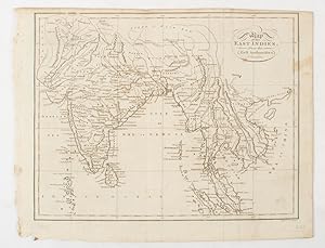
Map of the East Indies from the Best Authorities.
Publicado por (W. and D. Brownlie) [1805]., London & Glasgow., 1805
Librería: Asia Bookroom ANZAAB/ILAB, Canberra, ACT, Australia
Miembro de asociaci¾n: ANZAAB ILAB
Calificaci¾n del vendedor: 5 de 5 estrellas
EUR 129,36
Convertir monedaEUR 21,57 gastos de envĒo desde Australia a Espa±aCantidad disponible: 1 disponibles
A±adir al carritoEngraved map, 18.7 x 23.9 cm, original folds, age toned and spotted, inner margin a trifle ragged, paper thinning in a few spots, in good condition. Attractive map engraved for "A System of Geography; or A Descriptive, Historical, and Philosophical View of the Several Quarters of the World" published in 1805.
-
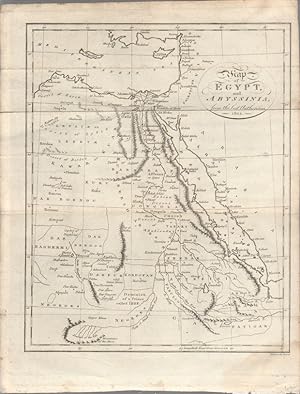
Map of Egypt, and Abyssinia, from the best Authorities.
Publicado por circa1803., (London)., 1803
Librería: Asia Bookroom ANZAAB/ILAB, Canberra, ACT, Australia
Miembro de asociaci¾n: ANZAAB ILAB
Calificaci¾n del vendedor: 5 de 5 estrellas
EUR 143,73
Convertir monedaEUR 21,57 gastos de envĒo desde Australia a Espa±aCantidad disponible: 1 disponibles
A±adir al carritoEngraved map, 23 x 18.5 cm, original folds, small split to one fold affecting the margin only, paper age- toned, lower corner darkened, and, on the verso inked circles to the lower half in an early hand, but in good condition. Finely engraved early 19th Century map also showing, to the north, Syria, Palestine and Cyprus and Darfur and Mountains of the Moon, Sources of the Nile to the South.


