
Mark delahay (4 resultados)

Editorial: Daniel H. Newhall, New York, 1939
Librería: Peter L. Masi - books, MONTAGUE, MA, Estados Unidos de AmericaPeter L. Masi - books
Contactar con el vendedorVendedor de 4 estrellasMiembro de asociación: SNEAB
Condición: Usado - Bueno
EUR 13,57
Envío por EUR 4,70Se envía dentro de Estados Unidos de AmericaCantidad disponible: 5 disponibles
Pamphlet. Condición: Used - Very Good. New York: Daniel H. Newhall, 1939. 16 pages. Texts of 2 Lincoln letters. 9.5 x 6", printed wrapper. VG.
Idioma: Inglés
- Tapa dura
- Impresión bajo demanda
Librería: S N Books World, Delhi, IndiaS N Books World
Contactar con el vendedorVendedor de 5 estrellasCondición: Nuevo
EUR 21,71
Gastos de envío gratisSe envía de India a Estados Unidos de AmericaCantidad disponible: 18 disponibles
LeatherBound. Condición: New. BOOKS ARE EXEMPT FROM IMPORT DUTIES AND TARIFFS; NO EXTRA CHARGES APPLY. Leather Binding on Spine and Corners with Golden leaf printing on spine. Bound in genuine leather with Satin ribbon page markers and Spine with raised gilt bands. A perfect gift for your loved ones. Reprinted from 1939 edition.… NO changes have been made to the original text. This is NOT a retyped or an ocr'd reprint. Illustrations, Index, if any, are included in black and white. Each page is checked manually before printing. As this print on demand book is reprinted from a very old book, there could be some missing or flawed pages, but we always try to make the book as complete as possible. Fold-outs, if any, are not part of the book. If the original book was published in multiple volumes then this reprint is of only one volume, not the whole set and contains approximately 28 pages. IF YOU WISH TO ORDER PARTICULAR VOLUME OR ALL THE VOLUMES YOU CAN CONTACT US. Resized as per current standards. Sewing binding for longer life, where the book block is actually sewn (smythe sewn/section sewn) with thread before binding which results in a more durable type of binding. Language: English.
Editorial: Surveyor General's Office, Leavenworth, Kansas, 1862
Librería: Argosy Book Store, ABAA, ILAB, New York, NY, Estados Unidos de AmericaArgosy Book Store, ABAA, ILAB
Contactar con el vendedorVendedor de 5 estrellasCondición: Usado - Bueno
EUR 226,21
Envío por EUR 5,27Se envía dentro de Estados Unidos de AmericaCantidad disponible: 1 disponibles
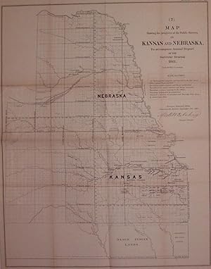
unbound. Condición: very good(+). Map. Uncolored lithograph. Image measures 23" x 18.5". Early map illustrating the progress of public surveys in Kansas and Nebraska. Shows townships, towns, waterways, Indian reservations and trust lands. A fascinating look at the changing American west in the 1860s. Minor toning along original…folds. The General Land Office was an independent agency in the United States that was in charge of mapping public domain lands.
Editorial: Surveyor General's Office c. 1862, Leavenworth, Kansas, 1862
- Mapa
Librería: Alexandre Antique Prints, Maps & Books, Toronto, ON, CanadaAlexandre Antique Prints, Maps & Books
Contactar con el vendedorVendedor de 4 estrellasCondición: Usado - Bueno
EUR 678,63
Envío por EUR 5,27Se envía de Canada a Estados Unidos de AmericaCantidad disponible: 1 disponibles
Condición: Very Good. Size : 592x499 (mm), 23.31x19.65 (Inches), Hand Colored.

