
Importe total (1 artículo artículos):
Destino del pedido:

map asia (214 resultados)
Ir a los resultados principales
Filtros de búsqueda
Tipo de artículo
- Todos los tipos de productos
- Libros (62)
- Revistas y publicaciones (No hay ningún otro resultado que coincida con este filtro.)
- Cómics (No hay ningún otro resultado que coincida con este filtro.)
- Partituras (No hay ningún otro resultado que coincida con este filtro.)
- Arte, grabados y pósters (1)
- Fotografías (No hay ningún otro resultado que coincida con este filtro.)
- Mapas (151)
- Manuscritos y coleccionismo de papel (No hay ningún otro resultado que coincida con este filtro.)
Condición Más información
- Nuevo (No hay ningún otro resultado que coincida con este filtro.)
- Como nuevo, Excelente o Muy bueno (No hay ningún otro resultado que coincida con este filtro.)
- Bueno o Aceptable (30)
- Regular o Pobre (No hay ningún otro resultado que coincida con este filtro.)
- Tal como se indica (184)
Encuadernación
Más atributos
- Primera edición (20)
- Firmado (2)
- Sobrecubierta (No hay ningún otro resultado que coincida con este filtro.)
- Con imágenes (183)
- No impresión bajo demanda (214)
Idioma (2)
Gastos de envío gratis
- Envío gratis a Estados Unidos de America (No hay ningún otro resultado que coincida con este filtro.)
Ubicación del vendedor
Valoración de los vendedores
-

ASIA, AN ANTIQUE MAP CIRCA 1860
Idioma: Inglés
Publicado por LONDON PRINTING AND PUBLISHING COMPANY, London, 1860
Librería: K Books Ltd ABA ILAB, York, YORKS, Reino Unido
Miembro de asociación: ABA ILAB PBFA
Calificación del vendedor: 5 de 5 estrellas

Original o primera edición
EUR 15,36
Envío por EUR 22,54
Se envía de Reino Unido a Estados Unidos de AmericaCantidad disponible: 1 disponibles
Ańadir al carritoSingle Sheet Engraving. Condición: Very Good. No Jacket. First Edition. ASIA, RUSSIAN CENTRAL ASIA DOWN TO PAPUA NEW GUINEA AN ANTIQUE MAP CIRCA 1860. mEASURES 13 X 10 INCHES, ELABORATE BORDER, CIRCA 1860. DISPATCH WELL PACKED ROLLED IN A STRONG TUBE, VERY GOOD CONDITION, SPLENDID VALUE.
-
ASIA MINOR, , AN ANTIQUE MAP CIRCA 1860
Idioma: Inglés
Publicado por LONDON PRINTING AND PUBLISHING COMPANY, London, 1860
Librería: K Books Ltd ABA ILAB, York, YORKS, Reino Unido
Miembro de asociación: ABA ILAB PBFA
Calificación del vendedor: 5 de 5 estrellas
Original o primera edición
EUR 15,36
Envío por EUR 22,54
Se envía de Reino Unido a Estados Unidos de AmericaCantidad disponible: 1 disponibles
Ańadir al carritoSingle Sheet Engraving. Condición: Very Good. No Jacket. First Edition. ASIA MINOR, BLACK SEA TO CYPRUS, GREECE TO ARMENIA AN ANTIQUE MAP CIRCA 1860. MEASURES 13 X 10 INCHES, ELABORATE BORDER, CIRCA 1860. DISPATCH WELL PACKED ROLLED IN A STRONG TUBE, VERY GOOD CONDITION, SPLENDID VALUE.
-
Southeast Asia Chronicle, Issue No. 63, July-August 1978: Succession Crisis in Indonesia: A Dictatorship Self-Destructs
Publicado por Southeast Asia Resource Center, Berkeley, CA, 1978
Librería: Ground Zero Books, Ltd., Silver Spring, MD, Estados Unidos de America
Calificación del vendedor: 5 de 5 estrellas
Original o primera edición
EUR 22,38
Envío por EUR 4,35
Se envía dentro de Estados Unidos de AmericaCantidad disponible: 1 disponibles
Ańadir al carritoWraps. Tam, Frank (Map); Finley, Lowell (Photograph) Ilustrador. 28 cm. 22 pages. Ilustrations. Map. Notes. Footnotes. Front cover torn. Half of back cover gone. Continues numeration of: Indochina chronicle. First issue under the new name. Founded in 1971 to inform the American people, legislators, and media about the war in Indochina as well as disseminating information about Laos, Cambodia and Vietnam; changed name to Southeast Asia Resource Center in 1976; absorbed by Asia Research Center in 1982. Fair. Mailing laber on rear cover. Has some wear and soiling. Presumed first edition/first printing thus.
-
kleinasien und ostliches mittelmeer
Publicado por Other, Other
Librería: Hoffman Books, ABAA, IOBA, Columbus, OH, Estados Unidos de America
Miembro de asociación: ABAA ILAB IOBA
Calificación del vendedor: 3 de 5 estrellas

EUR 21,94
Envío por EUR 6,95
Se envía dentro de Estados Unidos de AmericaCantidad disponible: 1 disponibles
Ańadir al carritoSOFTCOVER. Condición: Very Good. Large folding road map of Asia Minor and the Eastern Mediterranean. Very Good condition. 43" x 33.".
-
Southeast Asia Chronicle, Issue No. 61, March-April, 1978: Laos Recovers from America's War
Publicado por Southeast Asia Resource Center, Berkeley, CA, 1978
Librería: Ground Zero Books, Ltd., Silver Spring, MD, Estados Unidos de America
Calificación del vendedor: 5 de 5 estrellas
Original o primera edición
EUR 31,33
Envío por EUR 4,35
Se envía dentro de Estados Unidos de AmericaCantidad disponible: 1 disponibles
Ańadir al carritoWraps. Tam, Frank (Map); Finley, Lowell (Photograph) Ilustrador. 28 cm. 20 pages. Ilustrations. Map. Continues numeration of: Indochina chronicle. First issue under the new name. Founded in 1971 to inform the American people, legislators, and media about the war in Indochina as well as disseminating information about Laos, Cambodia and Vietnam; changed name to Southeast Asia Resource Center in 1976; absorbed by Asia Research Center in 1982. Good. Mailing laber on rear cover. Has some wear and soiling. Presumed first edition/first printing thus.
-
CENTRAL ASIA & THE INDIAN FRONTIER - an Original Coloured Map, Printed C1908
Idioma: Inglés
Publicado por George Philip & Son/The London Geographical Institute, London, 1908
Librería: K Books Ltd ABA ILAB, York, YORKS, Reino Unido
Miembro de asociación: ABA ILAB PBFA
Calificación del vendedor: 5 de 5 estrellas
EUR 17,86
Envío por EUR 22,54
Se envía de Reino Unido a Estados Unidos de AmericaCantidad disponible: 1 disponibles
Ańadir al carritoNo Binding. Condición: Very Good. An original map, printed in full colour, central fold. A map of Central Asia and the Indian Frontier showing the railways and the steamer routes connecting them.
-
Asia Minor - Antique Map, Contemporary Colouring 1798
Idioma: Inglés
Publicado por R Wilkinson, London, 1796
Librería: K Books Ltd ABA ILAB, York, YORKS, Reino Unido
Miembro de asociación: ABA ILAB PBFA
Calificación del vendedor: 5 de 5 estrellas
EUR 29,76
Envío por EUR 22,54
Se envía de Reino Unido a Estados Unidos de AmericaCantidad disponible: 1 disponibles
Ańadir al carritoNo Binding. Condición: Very Good. A splendid original antique map Asia Minor. Contemporary coloring and in excellent condition. Mounted and ready to frame. Extremely decorative and printed in 1796. Very attractive detailed map.
-
Asia - Antiquarian Coloured Map
Idioma: Inglés
Publicado por Collins, London
Librería: K Books Ltd ABA ILAB, York, YORKS, Reino Unido
Miembro de asociación: ABA ILAB PBFA
Calificación del vendedor: 5 de 5 estrellas
EUR 29,76
Envío por EUR 22,54
Se envía de Reino Unido a Estados Unidos de AmericaCantidad disponible: 1 disponibles
Ańadir al carritoNo Binding. Condición: Very Good. Engraved & Drawn By J Archer Ilustrador. An original antique map of Asia, printed ca. 1840. Mounted and ready to frame. Contemporary colouring in outline. In excellent condition, decorative and impressive. A clear map showing the main Empires & Countries of Asia from the Mediterranean to Japan.
-
Classical Greece & Asia Minor & Islands - Antique Hand Coloured Classical Map ( Attractive Colouring and Detailed)
Idioma: Inglés
Publicado por Philadelphia, 1830
Librería: K Books Ltd ABA ILAB, York, YORKS, Reino Unido
Miembro de asociación: ABA ILAB PBFA
Calificación del vendedor: 5 de 5 estrellas
EUR 29,76
Envío por EUR 22,54
Se envía de Reino Unido a Estados Unidos de AmericaCantidad disponible: 1 disponibles
Ańadir al carritoNo Binding. Condición: Very Good. Antique hand-coloured map. Plate size approx. 10 x 8.5 ins, 26 x 22cms. Mounted and ready to frame, mount/matted size approx. 14 x 12 ins, 38 x 32cms, VERY GOOD, Probable printed in Philadelphia in 1830's. Attractive, Decorative and unusual.
-
Map -Asia - China and Japan - 19th Century
Idioma: Inglés
Ańo de publicación: 1880
Librería: K Books Ltd ABA ILAB, York, YORKS, Reino Unido
Miembro de asociación: ABA ILAB PBFA
Calificación del vendedor: 5 de 5 estrellas
EUR 17,86
Envío por EUR 22,54
Se envía de Reino Unido a Estados Unidos de AmericaCantidad disponible: 1 disponibles
Ańadir al carritoNo Binding. Condición: Very Good. An antique map, very good condition. Mounted - matted - and ready to frame. Mount size approx 12 x 10 inches, 36 x 30 cms. Original contemporary colouring. Circa 1880. Very detailed - Shows --- Asia - - from Arabia to New Quinea - attractively coloured - quite detailed - very attractive - very reasonably priced.
-
Asia - Antique Map, Contemporary Colouring 1798
Idioma: Inglés
Publicado por R Wilkinson, London, 1800
Librería: K Books Ltd ABA ILAB, York, YORKS, Reino Unido
Miembro de asociación: ABA ILAB PBFA
Calificación del vendedor: 5 de 5 estrellas
EUR 35,72
Envío por EUR 22,54
Se envía de Reino Unido a Estados Unidos de AmericaCantidad disponible: 1 disponibles
Ańadir al carritoNo Binding. Condición: Very Good. E Bourne Ilustrador. A splendid original antique map of Asia. Contemporary colouring and in excellent condition. Mounted and ready to frame. Extremely decorative and printed in 1800. Detailed and attractive historical map of Asia Minor - Reditus Decem Millium Graecorum - frmo Macedonia in the west to Armenia in the east.
-
Macedonia, Asia Minor - The Countries Travelled By The Apostles -Antique Map, Contemporary Colouring 1798
Idioma: Inglés
Publicado por R Wilkinson, London, 1798
Librería: K Books Ltd ABA ILAB, York, YORKS, Reino Unido
Miembro de asociación: ABA ILAB PBFA
Calificación del vendedor: 5 de 5 estrellas
EUR 35,72
Envío por EUR 22,54
Se envía de Reino Unido a Estados Unidos de AmericaCantidad disponible: 1 disponibles
Ańadir al carritoNo Binding. Condición: Very Good. W T Davis Ilustrador. A splendid original antique map of Asia Minor and Macedonia. Contemporary coloring and in excellent condition. Mounted and ready to frame. Extremely decorative and printed in 1798. Detailed and attractive map.
-
Greece, Asia & Northern Africa - Antique Map, Contemporary Colouring 1798
Idioma: Inglés
Publicado por R Wilkinson, London, 1800
Librería: K Books Ltd ABA ILAB, York, YORKS, Reino Unido
Miembro de asociación: ABA ILAB PBFA
Calificación del vendedor: 5 de 5 estrellas
EUR 35,72
Envío por EUR 22,54
Se envía de Reino Unido a Estados Unidos de AmericaCantidad disponible: 1 disponibles
Ańadir al carritoNo Binding. Condición: Very Good. E Bourne Ilustrador. A splendid original antique map. Contemporary colouring and in excellent condition. Mounted and ready to frame. Extremely decorative and printed in 1800. Detailed and attractive map - "Patriarchati Oreintales", centred on the Mediterranean.
-
Asia, Northern Africa & Europe in Classical Times - Antique Map, Contemporary Colouring 1798
Idioma: Inglés
Publicado por R Wilkinson, London, 1798
Librería: K Books Ltd ABA ILAB, York, YORKS, Reino Unido
Miembro de asociación: ABA ILAB PBFA
Calificación del vendedor: 5 de 5 estrellas
EUR 35,72
Envío por EUR 22,54
Se envía de Reino Unido a Estados Unidos de AmericaCantidad disponible: 1 disponibles
Ańadir al carritoNo Binding. Condición: Very Good. A splendid original antique map of Europe Norhthern Africa and Asia. Contemporary coloring and in excellent condition. Mounted and ready to frame. Extremely decorative and printed in 1798. Detailed and attractive map. Entitled " Imperiorum Antiquorum" with table inset "Tabula Regnorum Chronologica".
-
Tourist's and Student's Manual of Languages (22 languages)
Publicado por Simpkin, Marshall, Hamilton, Kent, & Co.,Ltd., London, 1912
Librería: Dave Shoots, Bookseller, Saint John, NB, Canada
Calificación del vendedor: 5 de 5 estrellas
EUR 35,81
Envío por EUR 17,38
Se envía de Canada a Estados Unidos de AmericaCantidad disponible: 1 disponibles
Ańadir al carritoHardcover. Condición: Very Good. No Jacket. Coloured Foldout Map of Asia Ilustrador. Seventh Edition. Original red cloth with gilt lettering on boards. Also: How to Learn a Language, Pronunciation, Money and Exchange Table, Motor Terms, etc. This edition has been enlarged by 12 pages. Several hundred additional words and sentences in the various languages have been added. The title page doesn't mention it, but there is a colour foldout map of Asia in the back. 128 pp., plus map and several ads. Minor fading to cover foot, and bumped corners. Several corner tip turnups. Size: 16mo - over 5ľ" - 6ľ" tall. Book.
-
Map of Asia - an Original Engraving
Idioma: Inglés
Librería: K Books Ltd ABA ILAB, York, YORKS, Reino Unido
Miembro de asociación: ABA ILAB PBFA
Calificación del vendedor: 5 de 5 estrellas
EUR 23,81
Envío por EUR 22,54
Se envía de Reino Unido a Estados Unidos de AmericaCantidad disponible: 1 disponibles
Ańadir al carritoNo Binding. Condición: Very Good. A fine Engraving - printed circa 1870. Mounted and ready to frame. A fine opportunity to purchase an attractive and decorative engraved Map of Asia.
-
Map of Asia Minor - an Original Engraving
Idioma: Inglés
Librería: K Books Ltd ABA ILAB, York, YORKS, Reino Unido
Miembro de asociación: ABA ILAB PBFA
Calificación del vendedor: 5 de 5 estrellas
EUR 23,81
Envío por EUR 22,54
Se envía de Reino Unido a Estados Unidos de AmericaCantidad disponible: 1 disponibles
Ańadir al carritoNo Binding. Condición: Very Good. A fine Engraving - printed circa 1870. Mounted and ready to frame. A fine opportunity to purchase an attractive and decorative engraved Map of Asia Minor.
-
ASIA - an Original Antique Coloured Map
Idioma: Inglés
Ańo de publicación: 1865
Librería: K Books Ltd ABA ILAB, York, YORKS, Reino Unido
Miembro de asociación: ABA ILAB PBFA
Calificación del vendedor: 5 de 5 estrellas
EUR 23,81
Envío por EUR 22,54
Se envía de Reino Unido a Estados Unidos de AmericaCantidad disponible: 1 disponibles
Ańadir al carritoNo Binding. Condición: Very Good. An original antique coloured Map, colouring contemporary and rather strange, the sea not being very differentiated from the land. Mounted - matted - and ready to frame. Very good condition - a splendid map - centring on Asia, the area shown is from Sweden at the top left to Australia at the bottom right.
-

Tourist Map of Korea
Publicado por White Lotus Press, Bangkok, 1970
Librería: SEATE BOOKS, APO, AP, Estados Unidos de America
Calificación del vendedor: 5 de 5 estrellas
EUR 36,66
Envío por EUR 17,38
Se envía dentro de Estados Unidos de AmericaCantidad disponible: 1 disponibles
Ańadir al carritoPaperback. Condición: Good. Estado de la sobrecubierta: no dj. Tourist Map of Korea. Book.
-
Asia - An Original Antique Map.
Idioma: Inglés
Publicado por Fullerton, 1830
Librería: K Books Ltd ABA ILAB, York, YORKS, Reino Unido
Miembro de asociación: ABA ILAB PBFA
Calificación del vendedor: 5 de 5 estrellas
EUR 41,67
Envío por EUR 22,54
Se envía de Reino Unido a Estados Unidos de AmericaCantidad disponible: 1 disponibles
Ańadir al carritoNo Binding. Condición: Very Good. A splendid original antique delicately (but not contemporary) hand-coloured map. Mounted (matted) and ready to fame. Mount size approx. 11 x 9 inches, 28 x 23 cms. Excellent condition. c. 1830.
-
Asia Minor - Antiquarian Hand Coloured Map
Idioma: Inglés
Publicado por Tallis, London, 1860
Librería: K Books Ltd ABA ILAB, York, YORKS, Reino Unido
Miembro de asociación: ABA ILAB PBFA
Calificación del vendedor: 5 de 5 estrellas
EUR 59,53
Envío por EUR 22,54
Se envía de Reino Unido a Estados Unidos de AmericaCantidad disponible: 1 disponibles
Ańadir al carritoNo Binding. Condición: Very Good. An original antique hand coloured map - printed by Tallis about 1860 - mounted and ready to frame - rather attractive and somewhat uncommon .With vignettes Turks, Rhodes, etc.
-
MAP OF ASIA MINOR Antique Map
Idioma: Inglés
Ańo de publicación: 1798
Librería: K Books Ltd ABA ILAB, York, YORKS, Reino Unido
Miembro de asociación: ABA ILAB PBFA
Calificación del vendedor: 5 de 5 estrellas
EUR 35,72
Envío por EUR 22,54
Se envía de Reino Unido a Estados Unidos de AmericaCantidad disponible: 1 disponibles
Ańadir al carritoNo Binding. Condición: Good. An original antique map, mounted and ready to frame. Decorative and with considerable detail, scarce - detailed map. Very Attractive. Hand coloured, colouring not contemporary but delicately and expertly done. Shows the whole of Asia Minor Antiqua, with Latin text.
-
ASIA MAP. An Original Hand-Coloured Engraved Map.
Idioma: Inglés
Ańo de publicación: 1790
Librería: K Books Ltd ABA ILAB, York, YORKS, Reino Unido
Miembro de asociación: ABA ILAB PBFA
Calificación del vendedor: 5 de 5 estrellas
EUR 41,67
Envío por EUR 22,54
Se envía de Reino Unido a Estados Unidos de AmericaCantidad disponible: 1 disponibles
Ańadir al carritoNo Binding. Condición: Very Good. Russell, J Ilustrador. An original, hand-coloured engraved map; colouring not contemporary, but delicately and expertly done. Engraved c 1790. Will come mounted (matted) and ready to frame - mount size 13 x 11 inches. An opportunity to buy a decorative and attractive antique map of the whole of Asia.
-
Turkey with Provinces in Asia Minor - an Antique Map
Idioma: Inglés
Librería: K Books Ltd ABA ILAB, York, YORKS, Reino Unido
Miembro de asociación: ABA ILAB PBFA
Calificación del vendedor: 5 de 5 estrellas
EUR 41,67
Envío por EUR 22,54
Se envía de Reino Unido a Estados Unidos de AmericaCantidad disponible: 1 disponibles
Ańadir al carritoNo Binding. Condición: Very Good. Engraved By Walker Ilustrador. A fine antique map in very good condition - printed in circa 1844. Mounted (matted) and ready to frame. Engraved size approx 16 x 13 Ins, 41 x 33 Cms. Mounted size approx 19 x 16 in, 49 x 41cm. Coloured in outline, hand colouring contemporary. A fine engraved map of Turkey with Provinces in Asia Minor.
-
MAP OF ASIA - an Original Antique Hand Coloured Map
Idioma: Inglés
Ańo de publicación: 1840
Librería: K Books Ltd ABA ILAB, York, YORKS, Reino Unido
Miembro de asociación: ABA ILAB PBFA
Calificación del vendedor: 5 de 5 estrellas
EUR 47,62
Envío por EUR 22,54
Se envía de Reino Unido a Estados Unidos de AmericaCantidad disponible: 1 disponibles
Ańadir al carritoNo Binding. Condición: Very Good. A splendid map. Partially hand coloured - colouring not contemporary but delicately executed . Mounted - matted - and ready to frame . In very good condition. Printed circa 1840. Map of Asia, including Australia, well-defined.
-
Map of Asia Minor - Fine Detailed Map - an Original Engraving
Idioma: Inglés
Ańo de publicación: 1800
Librería: K Books Ltd ABA ILAB, York, YORKS, Reino Unido
Miembro de asociación: ABA ILAB PBFA
Calificación del vendedor: 5 de 5 estrellas
EUR 47,62
Envío por EUR 22,54
Se envía de Reino Unido a Estados Unidos de AmericaCantidad disponible: 1 disponibles
Ańadir al carritoNo Binding. Condición: Very Good. A fine engraving - printed circa 1800. Mounted and ready to frame. Hand colouring not contemporary, but delicately and expertly executed. A fine opportunity to purchase an attractive and decorative engraving - Map of Asia Minor.
-
Africa, Europe & Asia - an Original Hand-Coloured Map Printed C. 1764
Idioma: Inglés
Librería: K Books Ltd ABA ILAB, York, YORKS, Reino Unido
Miembro de asociación: ABA ILAB PBFA
Calificación del vendedor: 5 de 5 estrellas
EUR 47,62
Envío por EUR 22,54
Se envía de Reino Unido a Estados Unidos de AmericaCantidad disponible: 1 disponibles
Ańadir al carritoNo Binding. Condición: Very Good. An original antique hand-coloured circular globe map of Africa, Europe & Asia. Mounted and ready to frame . Very good condition . A splendid vintage map - decorative, attractive and somewhat uncommon. An impressive map with a great amount of detail with fine non-contemporary colouring.
-
Asia - an Antique Map
Idioma: Inglés
Librería: K Books Ltd ABA ILAB, York, YORKS, Reino Unido
Miembro de asociación: ABA ILAB PBFA
Calificación del vendedor: 5 de 5 estrellas
EUR 47,62
Envío por EUR 22,54
Se envía de Reino Unido a Estados Unidos de AmericaCantidad disponible: 1 disponibles
Ańadir al carritoNo Binding. Condición: Very Good. Engraved By Walker Ilustrador. A fine antique map in very good condition - printed in circa 1844. Mounted (matted) and ready to frame. Engraved size approx 16 x 13 Ins, 41 x 33 Cms. Mounted size approx 19 x 16 in, 49 x 41cm. Coloured in outline, hand colouring contemporary. A fine engraved map of Asia.
-
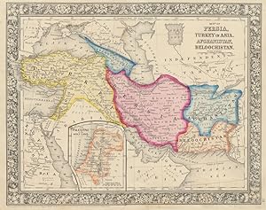
Map of Persia, Turkey in Asia, Afghanistan, Beloochistan
Publicado por S. Augustus Mitchell, Jr., New York, 1860
Librería: Main Street Fine Books & Mss, ABAA, Galena, IL, Estados Unidos de America
Miembro de asociación: ABAA ILAB MWABA
Calificación del vendedor: 5 de 5 estrellas
Mapa
EUR 58,18
Envío por EUR 5,21
Se envía dentro de Estados Unidos de AmericaCantidad disponible: 1 disponibles
Ańadir al carritoFolio (15Ľ" X 12Ľ", image area 13Ľ" X 11Ľ"). Hand colored. Very good. Ligjht age toning and faint soiling about the edges. Attractive, nicely colored example of this map, many of whose names and boundaries have changed dramatically, from the 1864 edition of "Mitchell's New General Atlas, Containing Maps of the Various Countries of the World, Plans of Cities, Etc." "Transcaucasia" is now Armenia, Georgia and Azerbaijan, Turkey includes what is today Syria and Iraq, Persia is of course Iran, etc., etc. Inset at lower left depicts "Palestine or the Holy Land." Lovely coloring and sharp floral border.
-

Map of Hindoostan, Farther India, China, and Tibet
Publicado por S. Augustus Mitchell, Jr., New York, 1860
Librería: Main Street Fine Books & Mss, ABAA, Galena, IL, Estados Unidos de America
Miembro de asociación: ABAA ILAB MWABA
Calificación del vendedor: 5 de 5 estrellas
Mapa
EUR 58,18
Envío por EUR 5,21
Se envía dentro de Estados Unidos de AmericaCantidad disponible: 1 disponibles
Ańadir al carritoFolio (15Ľ" X 12Ľ", image area 13 3/4" X 11Ľ"). Hand colored. Very good. Light age toning and bit of faint soiling. Bright, boldly colored example of this fascinating and far-ranging map, a number of whose country names (Burma, Siam, Formosa, etc.) and boundaries (Tibet almost as large as China) are vastly different today, from the 1864 edition of "Mitchell's New General Atlas, Containing Maps of the Various Countries of the World, Plans of Cities, Etc." Attractive floral border.
