Importe total (1 artículo artículos):
Destino del pedido:

letts thomas (266 resultados)
Ir a los resultados principales
Filtros de búsqueda
Tipo de artículo
- Todos los tipos de productos
- Libros (48)
- Revistas y publicaciones (No hay ningún otro resultado que coincida con este filtro.)
- Cómics (No hay ningún otro resultado que coincida con este filtro.)
- Partituras (No hay ningún otro resultado que coincida con este filtro.)
- Arte, grabados y pósters (No hay ningún otro resultado que coincida con este filtro.)
- Fotografías (No hay ningún otro resultado que coincida con este filtro.)
- Mapas (217)
- Manuscritos y coleccionismo de papel (1)
Condición Más información
- Nuevo (2)
- Como nuevo, Excelente o Muy bueno (11)
- Bueno o Aceptable (226)
- Regular o Pobre (No hay ningún otro resultado que coincida con este filtro.)
- Tal como se indica (27)
Encuadernación
Más atributos
- Primera edición (11)
- Firmado (No hay ningún otro resultado que coincida con este filtro.)
- Sobrecubierta (No hay ningún otro resultado que coincida con este filtro.)
- Con imágenes (252)
- No impresión bajo demanda (264)
Idioma (2)
Gastos de envío gratis
Ubicación del vendedor
Valoración de los vendedores
-

Short Story International (Student Series)
Idioma: Inglés
Publicado por International Cultural Exchange, Inc., 1994
ISBN 10: 1555731201 ISBN 13: 9781555731205
Librería: Better World Books: West, Reno, NV, Estados Unidos de America
Calificación del vendedor: 5 de 5 estrellas

EUR 10,19
Gastos de envío gratis
Se envía dentro de Estados Unidos de AmericaCantidad disponible: 1 disponibles
Ańadir al carritoCondición: Good. Pages intact with minimal writing/highlighting. The binding may be loose and creased. Dust jackets/supplements are not included. Stock photo provided. Product includes identifying sticker. Better World Books: Buy Books. Do Good.
-

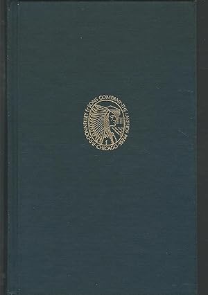
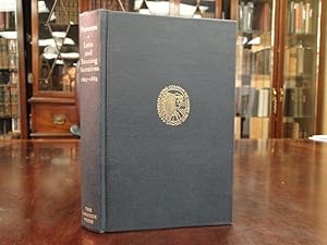
Pioneers: the Narratives of Noah Harris Letts and Thomas Allen Banning, 1825-1865
Publicado por Lakeside Press, 1972
Librería: Midtown Scholar Bookstore, Harrisburg, PA, Estados Unidos de America
Calificación del vendedor: 5 de 5 estrellas
EUR 3,78
Envío por EUR 5,10
Se envía dentro de Estados Unidos de AmericaCantidad disponible: 1 disponibles
Ańadir al carritoHardcover. Condición: Good. No dust jacket. Good hardcover with some shelfwear; may have previous owner's name inside. Standard-sized.
-
Pioneers: Narratives of Noah Harris Letts and Thomas Banning
Idioma: Inglés
Publicado por Lakeside Press, CHICAGO, 1972
Librería: Trouve Books, Cincinnati, OH, Estados Unidos de America
Calificación del vendedor: 4 de 5 estrellas

Original o primera edición
EUR 17,07
Gastos de envío gratis
Se envía dentro de Estados Unidos de AmericaCantidad disponible: 1 disponibles
Ańadir al carritoHardcover. Condición: Good+. Estado de la sobrecubierta: None. 1st Edition. HC without DJ, 8vo, 290 pages (VG-; corners bumped, crease length of spine cloth.).
-
Pioneers: Narratives of Noah Harris Letts and Thomas Allen Banning, 1825-1865
Idioma: Inglés
Publicado por Lakeside Press, Chicago, IL, 1972
Librería: Dorley House Books, Inc., Hagerstown, MD, Estados Unidos de America
Calificación del vendedor: 4 de 5 estrellas
Original o primera edición
EUR 17,50
Envío por EUR 7,35
Se envía dentro de Estados Unidos de AmericaCantidad disponible: 1 disponibles
Ańadir al carritoHardcover. Condición: Near Fine. B/W Illus Ilustrador. 1st. First Edition, Thus, limited edition; navy c; top edge gilt; 290 clean, unmarked pages.
-
Pioneers: Narratives of Noah Harris Letts and Thomas Allen Banning, 1825- 1865
Idioma: Inglés
Publicado por Lakeside Press, Chicago, IL, 1972
Librería: Dorley House Books, Inc., Hagerstown, MD, Estados Unidos de America
Calificación del vendedor: 4 de 5 estrellas
Original o primera edición
EUR 17,50
Envío por EUR 7,35
Se envía dentro de Estados Unidos de AmericaCantidad disponible: 1 disponibles
Ańadir al carritoHardcover. Condición: Near Fine. B/W Illus Ilustrador. 1st. First Edition, Thus, limited edition; navy c; top edge gilt; 290 clean, unmarked pages.
-
Pioneers: the Narratives of Noah Harris Letts and Thomas Allen Banning, 1825-1865
Publicado por Lakeside Press
Librería: Wonder Book, Frederick, MD, Estados Unidos de America
Miembro de asociación: ABAA ILAB
Calificación del vendedor: 5 de 5 estrellas
EUR 12,16
Gastos de envío gratis
Se envía dentro de Estados Unidos de AmericaCantidad disponible: 1 disponibles
Ańadir al carritoCondición: Very Good. Very Good condition. No Dust Jacket (American Frontier, Pioneer Life, History) A copy that may have a few cosmetic defects. May also contain a few markings such as an owner's name, short gifter's inscription or light stamp.
-
Pioneers: Narratives of Noah Harris Letts and Thomas Allen Banning,Lakeside Classic 1972
Publicado por R. R. Donnelley 1972 Chicago, 1972
Librería: Prairie Archives, Springfield, IL, Estados Unidos de America
Miembro de asociación: MWABA
Calificación del vendedor: 4 de 5 estrellas
EUR 13,13
Envío por EUR 4,46
Se envía dentro de Estados Unidos de AmericaCantidad disponible: 1 disponibles
Ańadir al carritovg+, issued w/o dj Cloth Top edges gilt.
-
Pioneers; Narratives of Noah Harris Letts and Thomas Allen Banning
Publicado por Lakeside Press, Chicago, 1972
Librería: James & Mary Laurie, Booksellers A.B.A.A, Minneapolis, MN, Estados Unidos de America
Miembro de asociación: ABAA ILAB MWABA
Calificación del vendedor: 3 de 5 estrellas

EUR 18,38
Gastos de envío gratis
Se envía dentro de Estados Unidos de AmericaCantidad disponible: 1 disponibles
Ańadir al carritoHardcover. Condición: Near fine. Bound in the publisher's original blue cloth, cover and spine stamped in gilt. Black & white illustrations throughout. Lightly rubbed at the extremities. No. 70 of the Lakeside Classics. Edited by Paul M. Angle.
-

Pioneers: Narratives of Noah Harris Letts and Thomas Allen Banning 1825-1865
Publicado por The Lakeside Press, Chicago, IL, 1972
Librería: Jeff Hirsch Books, ABAA, Wadsworth, IL, Estados Unidos de America
Miembro de asociación: ABAA ILAB MWABA
Calificación del vendedor: 5 de 5 estrellas
Original o primera edición
EUR 13,13
Envío por EUR 5,95
Se envía dentro de Estados Unidos de AmericaCantidad disponible: 1 disponibles
Ańadir al carritoFirst edition thus. Hardcover. 290 pages. The 70th entry in the longstanding series of books issued by the R.R. Donnelley & Sons Company as a Christmas gift for employees and friends of the press. Edited by Paul Angle. A near fine copy in blue cloth binding without dust jacket as issued. No dust jacket as issued.
-

Two Oxfordshire Anglo-Saxon Cemeteries: Berinsfield and Didcot (Thames Valley Landscapes Monograph ; No. 8)
Idioma: Inglés
Publicado por Oxford Archaeological Unit ; Oxford University Committee for Archaeology, 1995
ISBN 10: 0947816860 ISBN 13: 9780947816865
Librería: Katsumi-san Co., Cambridge, MA, Estados Unidos de America
Calificación del vendedor: 5 de 5 estrellas
Original o primera edición
EUR 30,63
Gastos de envío gratis
Se envía dentro de Estados Unidos de AmericaCantidad disponible: 1 disponibles
Ańadir al carritoSoft cover. Condición: Good. Hughes; Nichols; and Page Ilustrador. 1st Edition. Volume has wear and smells a bit like mothballs; tight, text clean. xviii, 274 p., illustrated. Oversize [otob: 20a].
-
Pioneers: Narratives of Noah Harris Letts and Thomas Allen Banning, 1825-1865
Publicado por Lakeside Press/R.R. Donnelley
Librería: Southampton Books, Sag Harbor, NY, Estados Unidos de America
Calificación del vendedor: 5 de 5 estrellas
Original o primera edición
EUR 17,50
Envío por EUR 3,39
Se envía dentro de Estados Unidos de AmericaCantidad disponible: 1 disponibles
Ańadir al carritoHardcover. Condición: Very Good. First Thus. First Edition Thus, First Printing. Published by Lakeside Press/R.R. Donnelley, 1972. Octavo. Blue cloth boards stamped in gold with gilt topstain. Book is very good; with no writing or names. Sharp corners and spine straight. Binding tight and pages crisp. Boards have light shelf wear with very light spotting to page ends. Book placed in custom acetate protector. 290 pages. 100% positive feedback. 30 day money back guarantee. NEXT DAY SHIPPING! Excellent customer service. Please email with any questions or if you would like a photo. All books packed carefully and ship with free delivery confirmation/tracking. All books come with free bookmarks. Ships from Southampton, New York. We Buy Books! Individual titles, libraries, collections. Message us if you have books to sell!
-
PIONEERS: Narratives of Noah Harris Letts and Thomas Allen Banning, 1825-1865
Publicado por The Lakeside Press (R.R. Donnelly & Sons Company), Chicago, 1972
Librería: Kubik Fine Books Ltd., ABAA, Dayton, OH, Estados Unidos de America
Miembro de asociación: ABAA ILAB IOBA MWABA
Calificación del vendedor: 5 de 5 estrellas
EUR 15,32
Envío por EUR 6,37
Se envía dentro de Estados Unidos de AmericaCantidad disponible: 1 disponibles
Ańadir al carritoHardcover. Condición: As New. 290p. A navy blue cloth hardcover book with a gilt top edge. Fine condition, clean and tight. A volume in the Lakeside Classics series.
-
Pioneers: Narratives of Noah Harris Letts and Thomas Allen Banning, 1825-1865 (The Lakeside Classics)
Publicado por The Lakeside Press / R.R. Donnelley & Sons, Chicago, 1972
Librería: Between the Covers-Rare Books, Inc. ABAA, Gloucester City, NJ, Estados Unidos de America
Miembro de asociación: ABAA ESA ILAB IOBA
Calificación del vendedor: 5 de 5 estrellas
EUR 17,50
Envío por EUR 4,67
Se envía dentro de Estados Unidos de AmericaCantidad disponible: 1 disponibles
Ańadir al carritoHardcover. Condición: Near Fine. Reprint. 290pp. Edited by Paul M. Angle. Spine slightly cocked, near fine without the dust jacket as issued.
-
PIONEERS Narratives of Noah Harris Letts and Thomas Allen Banning 1825 - 1865
Publicado por Chicago: Lakeside Press R. R. Donnelley and Sons, 1972
Librería: The Antiquarian Shop, Bend, OR, Estados Unidos de America
Calificación del vendedor: 5 de 5 estrellas
EUR 25,38
Gastos de envío gratis
Se envía dentro de Estados Unidos de AmericaCantidad disponible: 1 disponibles
Ańadir al carritoCloth. Condición: Near Fine. Number 70 in the Lakeside Classics Series. Fine, in original publisher's dark blue cloth, top edge gilt, gilt decoration on front cover and gilt lettering on spine.
-
PIONEERS: Narratives of Noah Harris Letts and Thomas Allen Banning 1825-1865/The Lakeside Classics
Publicado por The Lakeside Press/R. R. Donnelley & Sons Company, Chicago, IL, 1972
Librería: Shoemaker Booksellers, Gettysburg, PA, Estados Unidos de America
Calificación del vendedor: 5 de 5 estrellas
EUR 19,25
Envío por EUR 6,37
Se envía dentro de Estados Unidos de AmericaCantidad disponible: 1 disponibles
Ańadir al carritoHardcover. Condición: Near Fine. Estado de la sobrecubierta: No Dust Jacket. 290 pp. Original blue cloth covers w/ gilt title on spine. Binding lightly soiled. Top edge gilt. Previous owner's name stamp on front blank endpaper. Illust. w/ maps, b/w plates and drawings. Contents nice.
-
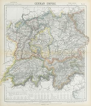
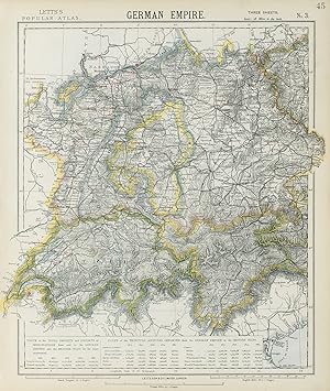
German Empire No 3
Ańo de publicación: 1889
Librería: Antiqua Print Gallery, London, Reino Unido
Calificación del vendedor: 4 de 5 estrellas
Mapa
EUR 4,71
Envío por EUR 11,44
Se envía de Reino Unido a Estados Unidos de AmericaCantidad disponible: 1 disponibles
Ańadir al carritoCondición: Good. GERMANY SWITZERLAND AUSTRIA. Baden Württemberg Bavaria Tyrol. LETTS 1889 map. Antique colour atlas map; Published by Mason & Payne. Most of the plates used for this atlas were original engraved for the SDUK atlas in the mid nineteenth century. The plates were later sold to Thomas Letts, and subsequently to Mason & Payne (1889). 41.5 x 35.0cm, 16.25 x 13.75 inches. Condition: Good. The image shown may have been taken from a different example of this map than that which is offered for sale. The map you will receive is in good condition but there may be minor variations in the condition from that shown in the image. There is nothing printed on the reverse side, which is plain.
-
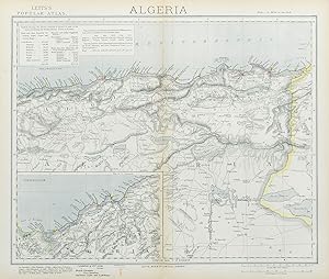
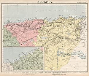
Algeria; Inset map of Continuation Algeria
Ańo de publicación: 1883
Librería: Antiqua Print Gallery, London, Reino Unido
Calificación del vendedor: 4 de 5 estrellas
Mapa
EUR 4,71
Envío por EUR 11,44
Se envía de Reino Unido a Estados Unidos de AmericaCantidad disponible: 1 disponibles
Ańadir al carritoCondición: Good. ALGERIA. North Africa. Algiers Oran Constantine. British Consuls. LETTS 1883 map. Antique colour atlas map; Published by Letts & Co. Most of the plates used for this atlas were original engraved for the SDUK atlas in the mid nineteenth century. The plates were later sold to Thomas Letts, and subsequently to Mason & Payne (1883). 36.0 x 42.5cm, 14.25 x 16.75 inches; this is a folding map. Condition: Good. The image shown may have been taken from a different example of this map than that which is offered for sale. The map you will receive is in good condition but there may be minor variations in the condition from that shown in the image. There is nothing printed on the reverse side, which is plain.
-
German Empire No 3
Ańo de publicación: 1883
Librería: Antiqua Print Gallery, London, Reino Unido
Calificación del vendedor: 4 de 5 estrellas
Mapa
EUR 4,71
Envío por EUR 11,44
Se envía de Reino Unido a Estados Unidos de AmericaCantidad disponible: 1 disponibles
Ańadir al carritoCondición: Good. SOUTH GERMANY SWITZERLAND AUSTRIA Baden Württemberg Bavaria Tyrol 1883 old map. Antique colour atlas map; Published by Letts & Co. Most of the plates used for this atlas were original engraved for the SDUK atlas in the mid nineteenth century. The plates were later sold to Thomas Letts, and subsequently to Mason & Payne (1883). 43.0 x 36.5cm, 17 x 14.5 inches; this is a folding map. Condition: Good. The image shown may have been taken from a different example of this map than that which is offered for sale. The map you will receive is in good condition but there may be minor variations in the condition from that shown in the image. There is nothing printed on the reverse side, which is plain.
-
Algeria; Inset map of Continuation Algeria
Ańo de publicación: 1889
Librería: Antiqua Print Gallery, London, Reino Unido
Calificación del vendedor: 4 de 5 estrellas
Mapa
EUR 4,71
Envío por EUR 11,44
Se envía de Reino Unido a Estados Unidos de AmericaCantidad disponible: 1 disponibles
Ańadir al carritoCondición: Good. ALGERIA. North Africa. Algier Algiers Oran Constantine. LETTS 1889 old map. Antique colour atlas map; Published by Mason & Payne. Most of the plates used for this atlas were original engraved for the SDUK atlas in the mid nineteenth century. The plates were later sold to Thomas Letts, and subsequently to Mason & Payne (1889). 34.5 x 40.5cm, 13.5 x 16 inches. Condition: Good. The image shown may have been taken from a different example of this map than that which is offered for sale. The map you will receive is in good condition but there may be minor variations in the condition from that shown in the image. There is nothing printed on the reverse side, which is plain.
-
Canada No 2
Ańo de publicación: 1889
Librería: Antiqua Print Gallery, London, Reino Unido
Calificación del vendedor: 4 de 5 estrellas
Mapa
EUR 4,71
Envío por EUR 11,44
Se envía de Reino Unido a Estados Unidos de AmericaCantidad disponible: 2 disponibles
Ańadir al carritoCondición: Good. QUEBEC Québec. St Lawrence lighthouses. Maine.New Brunswick.LETTS 1889 old map. Antique colour atlas map; Published by Mason & Payne. Most of the plates used for this atlas were original engraved for the SDUK atlas in the mid nineteenth century. The plates were later sold to Thomas Letts, and subsequently to Mason & Payne (1889). 35.0 x 41.0cm, 13.75 x 16.25 inches. Condition: Good. The image shown may have been taken from a different example of this map than that which is offered for sale. The map you will receive is in good condition but there may be minor variations in the condition from that shown in the image. There is nothing printed on the reverse side, which is plain.
-
German Empire No 3
Ańo de publicación: 1884
Librería: Antiqua Print Gallery, London, Reino Unido
Calificación del vendedor: 4 de 5 estrellas
Mapa
EUR 4,71
Envío por EUR 11,44
Se envía de Reino Unido a Estados Unidos de AmericaCantidad disponible: 1 disponibles
Ańadir al carritoCondición: Good. SOUTH GERMANY SWITZERLAND AUSTRIA Baden Württemberg Bavaria Tyrol 1884 old map. Antique colour atlas map; Published by Letts & Co. Most of the plates used for this atlas were original engraved for the SDUK atlas in the mid nineteenth century. The plates were later sold to Thomas Letts, and subsequently to Mason & Payne (1884). 43.0 x 36.5cm, 17 x 14.25 inches. Condition: Good. The image shown may have been taken from a different example of this map than that which is offered for sale. The map you will receive is in good condition but there may be minor variations in the condition from that shown in the image. There is nothing printed on the reverse side, which is plain.
-
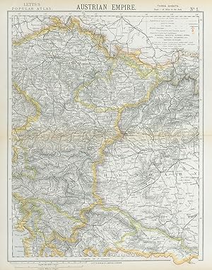
Austrian Empire No 1
Ańo de publicación: 1884
Librería: Antiqua Print Gallery, London, Reino Unido
Calificación del vendedor: 4 de 5 estrellas
Mapa
EUR 4,71
Envío por EUR 11,44
Se envía de Reino Unido a Estados Unidos de AmericaCantidad disponible: 1 disponibles
Ańadir al carritoCondición: Good. AUSTRIAN EMPIRE. Bohemia Moravia Styria Illyria Croatia Hungary. LETTS 1884 map. Antique colour atlas map; Published by Letts & Co. Most of the plates used for this atlas were original engraved for the SDUK atlas in the mid nineteenth century. The plates were later sold to Thomas Letts, and subsequently to Mason & Payne (1884). 43.5 x 33.5cm, 17 x 13.25 inches. Condition: Good. The image shown may have been taken from a different example of this map than that which is offered for sale. The map you will receive is in good condition but there may be minor variations in the condition from that shown in the image. There is nothing printed on the reverse side, which is plain.
-
France No 3
Ańo de publicación: 1883
Librería: Antiqua Print Gallery, London, Reino Unido
Calificación del vendedor: 4 de 5 estrellas
Mapa
EUR 4,71
Envío por EUR 11,44
Se envía de Reino Unido a Estados Unidos de AmericaCantidad disponible: 1 disponibles
Ańadir al carritoCondición: Good. FRANCE SOUTH. Lighthouses. UK-French trade 1876-1880. LETTS 1883 old map. Antique colour atlas map; Published by Letts & Co. Most of the plates used for this atlas were original engraved for the SDUK atlas in the mid nineteenth century. The plates were later sold to Thomas Letts, and subsequently to Mason & Payne (1883). 36.5 x 44.0cm, 14.25 x 17.25 inches; this is a folding map. Condition: Good. The image shown may have been taken from a different example of this map than that which is offered for sale. The map you will receive is in good condition but there may be minor variations in the condition from that shown in the image. There is nothing printed on the reverse side, which is plain.
-
Austrian Empire No 1
Ańo de publicación: 1883
Librería: Antiqua Print Gallery, London, Reino Unido
Calificación del vendedor: 4 de 5 estrellas
Mapa
EUR 4,71
Envío por EUR 11,44
Se envía de Reino Unido a Estados Unidos de AmericaCantidad disponible: 2 disponibles
Ańadir al carritoCondición: Good. AUSTRIAN EMPIRE. Bohemia Moravia Styria Illyria Croatia Hungary. LETTS 1883 map. Antique colour atlas map; Published by Letts & Co. Most of the plates used for this atlas were original engraved for the SDUK atlas in the mid nineteenth century. The plates were later sold to Thomas Letts, and subsequently to Mason & Payne (1883). 43.5 x 34.0cm, 17 x 13.5 inches; this is a folding map. Condition: Good. The image shown may have been taken from a different example of this map than that which is offered for sale. The map you will receive is in good condition but there may be minor variations in the condition from that shown in the image. There is nothing printed on the reverse side, which is plain.
-
France No 2
Ańo de publicación: 1889
Librería: Antiqua Print Gallery, London, Reino Unido
Calificación del vendedor: 4 de 5 estrellas
Mapa
EUR 4,71
Envío por EUR 11,44
Se envía de Reino Unido a Estados Unidos de AmericaCantidad disponible: 2 disponibles
Ańadir al carritoCondición: Good. NE FRANCE w/o Alsace Lorraine. Champagne Picardy Burgundy Nord.LETTS 1889 map. Antique colour atlas map; Published by Mason & Payne. Most of the plates used for this atlas were original engraved for the SDUK atlas in the mid nineteenth century. The plates were later sold to Thomas Letts, and subsequently to Mason & Payne (1889). 42.5 x 32.0cm, 16.5 x 12.5 inches. Condition: Good. The image shown may have been taken from a different example of this map than that which is offered for sale. The map you will receive is in good condition but there may be minor variations in the condition from that shown in the image. There is nothing printed on the reverse side, which is plain.
-
France No 3
Ańo de publicación: 1884
Librería: Antiqua Print Gallery, London, Reino Unido
Calificación del vendedor: 4 de 5 estrellas
Mapa
EUR 4,71
Envío por EUR 11,44
Se envía de Reino Unido a Estados Unidos de AmericaCantidad disponible: 1 disponibles
Ańadir al carritoCondición: Good. FRANCE SOUTH. Lighthouses. UK-French trade 1876-1880. LETTS 1884 old map. Antique colour atlas map; Published by Letts & Co. Most of the plates used for this atlas were original engraved for the SDUK atlas in the mid nineteenth century. The plates were later sold to Thomas Letts, and subsequently to Mason & Payne (1884). 36.0 x 43.0cm, 14.25 x 17 inches. Condition: Good. Tight top margin; The image shown may have been taken from a different example of this map than that which is offered for sale. The map you will receive is in good condition but there may be minor variations in the condition from that shown in the image. There is nothing printed on the reverse side, which is plain.
-
Canada No 2
Ańo de publicación: 1883
Librería: Antiqua Print Gallery, London, Reino Unido
Calificación del vendedor: 4 de 5 estrellas
Mapa
EUR 5,89
Envío por EUR 11,44
Se envía de Reino Unido a Estados Unidos de AmericaCantidad disponible: 2 disponibles
Ańadir al carritoCondición: Good. QUEBEC Québec. St Lawrence lighthouses. Maine. New Brunswick. LETTS 1883 map. Antique colour atlas map; Published by Letts & Co. Most of the plates used for this atlas were original engraved for the SDUK atlas in the mid nineteenth century. The plates were later sold to Thomas Letts, and subsequently to Mason & Payne (1883). 36.5 x 43.0cm, 14.25 x 17 inches; this is a folding map. Condition: Good. The image shown may have been taken from a different example of this map than that which is offered for sale. The map you will receive is in good condition but there may be minor variations in the condition from that shown in the image. There is nothing printed on the reverse side, which is plain.
-
Statistical map of Scotland No. 1
Ańo de publicación: 1883
Librería: Antiqua Print Gallery, London, Reino Unido
Calificación del vendedor: 4 de 5 estrellas
Mapa
EUR 5,89
Envío por EUR 11,44
Se envía de Reino Unido a Estados Unidos de AmericaCantidad disponible: 1 disponibles
Ańadir al carritoCondición: Good. SCOTLAND SOUTH. Railways lighthouses lifeboat stations. LETTS 1883 old map. Antique colour atlas map; Published by Letts & Co. Most of the plates used for this atlas were original engraved for the SDUK atlas in the mid nineteenth century. The plates were later sold to Thomas Letts, and subsequently to Mason & Payne (1883). 33.5 x 42.0cm, 13 x 16.5 inches; this is a folding map. Condition: Good. The image shown may have been taken from a different example of this map than that which is offered for sale. The map you will receive is in good condition but there may be minor variations in the condition from that shown in the image. There is nothing printed on the reverse side, which is plain.
-
Russia No.4
Ańo de publicación: 1884
Librería: Antiqua Print Gallery, London, Reino Unido
Calificación del vendedor: 4 de 5 estrellas
Mapa
EUR 5,89
Envío por EUR 11,44
Se envía de Reino Unido a Estados Unidos de AmericaCantidad disponible: 1 disponibles
Ańadir al carritoCondición: Good. RUSSIA Moscow-St Petersburg. Novgorod Smolensk Vologda Iarolslav LETTS 1884 map. Antique colour atlas map; Published by Letts & Co. Most of the plates used for this atlas were original engraved for the SDUK atlas in the mid nineteenth century. The plates were later sold to Thomas Letts, and subsequently to Mason & Payne (1884). 36.5 x 43.5cm, 14.25 x 17 inches. Condition: Good. Tight bottom margin below caption; Tight top margin; The image shown may have been taken from a different example of this map than that which is offered for sale. The map you will receive is in good condition but there may be minor variations in the condition from that shown in the image. There is nothing printed on the reverse side, which is plain.