Importe total (1 artículo artículos):
Destino del pedido:

j walker cartographer (2 resultados)
Ir a los resultados principales
Filtros de búsqueda
Tipo de artículo
- Todos los tipos de productos
- Libros (1)
- Revistas y publicaciones (No hay ningún otro resultado que coincida con este filtro.)
- Cómics (No hay ningún otro resultado que coincida con este filtro.)
- Partituras (No hay ningún otro resultado que coincida con este filtro.)
- Arte, grabados y pósters (No hay ningún otro resultado que coincida con este filtro.)
- Fotografías (No hay ningún otro resultado que coincida con este filtro.)
- Mapas (1)
- Manuscritos y coleccionismo de papel (No hay ningún otro resultado que coincida con este filtro.)
Condición Más información
- Nuevo (No hay ningún otro resultado que coincida con este filtro.)
- Como nuevo, Excelente o Muy bueno (No hay ningún otro resultado que coincida con este filtro.)
- Bueno o Aceptable (2)
- Regular o Pobre (No hay ningún otro resultado que coincida con este filtro.)
- Tal como se indica (No hay ningún otro resultado que coincida con este filtro.)
Encuadernación
- Todas
- Tapa dura (1)
- Tapa blanda (No hay ningún otro resultado que coincida con este filtro.)
Más atributos
- Primera edición (No hay ningún otro resultado que coincida con este filtro.)
- Firmado (No hay ningún otro resultado que coincida con este filtro.)
- Sobrecubierta (No hay ningún otro resultado que coincida con este filtro.)
- Con imágenes (2)
- No impresión bajo demanda (2)
Idioma (1)
Precio
- Cualquier precio
- Menos de EUR 20 (No hay ningún otro resultado que coincida con este filtro.)
- EUR 20 a EUR 45 (No hay ningún otro resultado que coincida con este filtro.)
- Más de EUR 45
Gastos de envío gratis
- Envío gratis a Estados Unidos de America (No hay ningún otro resultado que coincida con este filtro.)
Ubicación del vendedor
Valoración de los vendedores
-
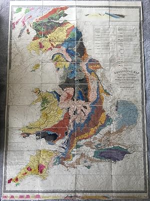
A Geological Map of England, Wales and Part of Scotland, Showing also the Inland Navigation by means of Rivers and Canals with their elevation in feet above the sea together with the Rail Roads and Principal Roads.
Publicado por J. & C. Walker, No.3 Burleigh Street, Strand. Circa 1835., 1835
Librería: Kerr & Sons Booksellers ABA, Cartmel, CMA, Reino Unido
Miembro de asociación: ABA ILAB
Calificación del vendedor: 5 de 5 estrellas

Mapa
EUR 1.790,78
Envío por EUR 34,77
Se envía de Reino Unido a Estados Unidos de AmericaCantidad disponible: 1 disponibles
Ańadir al carritoHardcover. Condición: Very Good. Measures: 1440mm x 1000mm. Published according to Act of Parliament by J. & C. Walker. Hand-coloured engraved folding map, dissected and mounted on linen, in 36 sections. With hand-coloured engraved 'Geological & mineralogical section from the Lands End to the German Ocean' across foot of map and hand-coloured engraved 'Geological & mineralogical section from the St. George's Channel to the German Ocean' at top right, above a hand-coloured engraved 'Explanation of the colouring', providing a geological key; engraved note on 'Metalliferous tracts of England and Wales' to lower left. An early state of James Knipe and John and Charles Walker's geological map of England, Wales and southern Scotland. Dated Dec. 18th 1835 at foot, this being one of the Walker re-issues with any mention of Knipe removed. Map housed in contemporary green cloth book-form box, gilt ruled spine with red leather title label, edges marbled. Extremities rubbed, particularly corners with some minor loss. Lower edge of map a little curled/creased. Otherwise a clean and bright example of this impressive geological map.
-
Travels in Syria and the Holy Land by the late John Lewis Burckhard. "Published by the Association for Promoting the Discovery of the Interior Parts of Africa. First edition.
Publicado por London: John Murray, Albemarle Street, 1822, 1822
Librería: Wittenborn Art Books, San Francisco, CA, Estados Unidos de America
Calificación del vendedor: 5 de 5 estrellas
EUR 2.940,01
Envío por EUR 8,78
Se envía dentro de Estados Unidos de AmericaCantidad disponible: 1 disponibles
Ańadir al carritoCondición: Good. 4to. 21 x 27cm. Modern tooled goatskin and marbled endpapers by the artisan binder Sasha Mosalov , with original spine labels preserved.[30]. 668pp. Very good.,Ownership signature of J. Neville White on top of title page. Lithograph portrait as frontispiece; 6 maps, of which 2 are fold-outs.OCLC Number / Unique Identifier:3673177: Engraved frontispiece portrait of author from a sketch by Henry Salt.