Importe total (1 artículo artículos):
Destino del pedido:

gray ormando willis (30 resultados)
Ir a los resultados principales
Filtros de búsqueda
Tipo de artículo
- Todos los tipos de productos
- Libros (11)
- Revistas y publicaciones (No hay ningún otro resultado que coincida con este filtro.)
- Cómics (No hay ningún otro resultado que coincida con este filtro.)
- Partituras (No hay ningún otro resultado que coincida con este filtro.)
- Arte, grabados y pósters (No hay ningún otro resultado que coincida con este filtro.)
- Fotografías (No hay ningún otro resultado que coincida con este filtro.)
- Mapas (19)
- Manuscritos y coleccionismo de papel (No hay ningún otro resultado que coincida con este filtro.)
Condición Más información
- Nuevo (No hay ningún otro resultado que coincida con este filtro.)
- Como nuevo, Excelente o Muy bueno (No hay ningún otro resultado que coincida con este filtro.)
- Bueno o Aceptable (18)
- Regular o Pobre (7)
- Tal como se indica (5)
Encuadernación
- Todas
- Tapa dura (4)
- Tapa blanda (No hay ningún otro resultado que coincida con este filtro.)
Más atributos
- Primera edición (2)
- Firmado (No hay ningún otro resultado que coincida con este filtro.)
- Sobrecubierta (No hay ningún otro resultado que coincida con este filtro.)
- Con imágenes (29)
- No impresión bajo demanda (30)
Idioma (1)
Precio
- Cualquier precio
- Menos de EUR 20 (No hay ningún otro resultado que coincida con este filtro.)
- EUR 20 a EUR 45
- Más de EUR 45
Gastos de envío gratis
- Envío gratis a Estados Unidos de America (No hay ningún otro resultado que coincida con este filtro.)
Ubicación del vendedor
Valoración de los vendedores
-
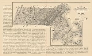
Climatological map of Massachusetts showing the average temperature, amount of rain fall &c. by Lorin Blodgett 1860
Ańo de publicación: 1871
Librería: Antiqua Print Gallery, London, Reino Unido
Calificación del vendedor: 4 de 5 estrellas

Mapa
EUR 28,35
EUR 11,47 shipping
Se envía de Reino Unido a Estados Unidos de AmericaCantidad disponible: 1 disponibles
Ańadir al carritoCondición: Good. Climatological map of Massachusetts average temperature. BLODGETT 1871. Antique map; Map by Lorin Blodgett, published by Henry Francis Walling & Ormando Willis Gray (1871). 37.5 x 62.0cm, 14.75 x 24.5 inches; this is a folding map. Condition: Good. There is text printed on the reverse side.
-
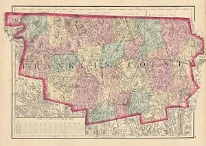
Franklin County
Ańo de publicación: 1871
Librería: Antiqua Print Gallery, London, Reino Unido
Calificación del vendedor: 4 de 5 estrellas
Mapa
EUR 28,35
EUR 11,47 shipping
Se envía de Reino Unido a Estados Unidos de AmericaCantidad disponible: 1 disponibles
Ańadir al carritoCondición: Good. Franklin County, Massachusetts. WALLING & GRAY 1871 old antique map plan chart. Antique hand coloured county map; Henry Francis Walling & Ormando Willis Gray (1871). 30.0 x 42.5cm, 11.75 x 16.75 inches. Condition: Good. Light spotting in margin. There is nothing printed on the reverse side, which is plain.
-
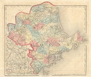
Essex County
Ańo de publicación: 1871
Librería: Antiqua Print Gallery, London, Reino Unido
Calificación del vendedor: 4 de 5 estrellas
Mapa
EUR 33,07
EUR 11,47 shipping
Se envía de Reino Unido a Estados Unidos de AmericaCantidad disponible: 1 disponibles
Ańadir al carritoCondición: Good. Essex County, Massachusetts. WALLING & GRAY 1871 old antique map plan chart. Antique hand coloured county map; Henry Francis Walling & Ormando Willis Gray (1871). 34.5 x 40.5cm, 13.5 x 16 inches; this is a folding map. Condition: Good. Tight bottom margin below caption; Light spotting. There is nothing printed on the reverse side, which is plain.
-
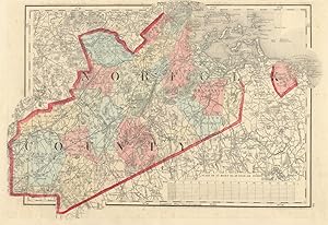
Norfolk County
Ańo de publicación: 1871
Librería: Antiqua Print Gallery, London, Reino Unido
Calificación del vendedor: 4 de 5 estrellas
Mapa
EUR 33,07
EUR 11,47 shipping
Se envía de Reino Unido a Estados Unidos de AmericaCantidad disponible: 1 disponibles
Ańadir al carritoCondición: Good. Norfolk County, Massachusetts. WALLING & GRAY 1871 old antique map plan chart. Antique hand coloured county map; Henry Francis Walling & Ormando Willis Gray (1871). 28.5 x 41.5cm, 11.25 x 16.5 inches. Condition: Good. Tight top margin. Repaired marginal tear. There is nothing printed on the reverse side, which is plain.
-

Bristol County
Ańo de publicación: 1871
Librería: Antiqua Print Gallery, London, Reino Unido
Calificación del vendedor: 4 de 5 estrellas
Mapa
EUR 38,98
EUR 11,47 shipping
Se envía de Reino Unido a Estados Unidos de AmericaCantidad disponible: 1 disponibles
Ańadir al carritoCondición: Good. Bristol County, Massachusetts. WALLING & GRAY 1871 old antique map plan chart. Antique hand coloured county map; Henry Francis Walling & Ormando Willis Gray (1871). 61.0 x 41.0cm, 24 x 16 inches; this is a folding map. Condition: Good. Light spotting. There is nothing printed on the reverse side, which is plain.
-
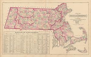
Map of Massachusetts comprising counties, towns, villages, railroads, stations, etc. H.F. Walling & O.W. Gray, Boston, 1871
Ańo de publicación: 1871
Librería: Antiqua Print Gallery, London, Reino Unido
Calificación del vendedor: 4 de 5 estrellas
Mapa
EUR 44,88
EUR 11,47 shipping
Se envía de Reino Unido a Estados Unidos de AmericaCantidad disponible: 1 disponibles
Ańadir al carritoCondición: Good. Map of Massachusetts comprising counties, towns WALLING & GRAY 1871 old. Antique hand coloured state map; Henry Francis Walling & Ormando Willis Gray (1871). 40.5 x 64.0cm, 15.75 x 25.25 inches; this is a folding map. Condition: Good. Light spotting. Split along fold repaired verso. There is nothing printed on the reverse side, which is plain.
-

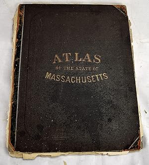
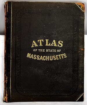
Official Topographical Atlas of Massachusetts,: From astronomical, trigonomical and various local surveys;
Publicado por Stedman, Brown & Lyon, 1871
Librería: Schoen Books, South Deerfield, MA, Estados Unidos de America
Miembro de asociación: SNEAB
Calificación del vendedor: 3 de 5 estrellas

EUR 328,72
EUR 7,02 shipping
Se envía dentro de Estados Unidos de AmericaCantidad disponible: 1 disponibles
Ańadir al carritoCondición: Good. Location:96 Folio spine repaired with new spine, new hinges also 100, [22] pages: 27 maps (26 color, some double); 45 cm. 17 1/4" x 14" "List of cities, towns, villages, post-offices, railways, and telegraph stations in Massachusetts": pages 95-100. Lists of "patrons" in Boston and vicinity and in Berkshire, Franklin, Hampshire, and Hampden counties 96.
-
Official Topographical Atlas of Massachusetts: From Astronomical, Trigonometrical and Various Local Surveys
Publicado por Stedman, Brown & Lyon, 1871
Librería: Sequitur Books, Boonsboro, MD, Estados Unidos de America
Miembro de asociación: IOBA
Calificación del vendedor: 5 de 5 estrellas

Original o primera edición
EUR 350,63
EUR 4,23 shipping
Se envía dentro de Estados Unidos de AmericaCantidad disponible: 1 disponibles
Ańadir al carritoHardcover. Condición: Fair. First Edition. Folio, 45 cm. Bound in publisher's cloth. 19, xx-xxi, [1], 22-23, xxiv-xxxi, 2-49 pages including 16 color maps (part double) tables. Hardcover. Poor binding. Refs: Phillips, 14399; Phillips. Maps of America, p. 401; LeGear. Atlases of the United States, L1551.
-
Official topographical atlas of Massachusetts,: From astronomical, trigonomical and various local surveys;
Publicado por Stedman, Brown & Lyon, 1871
Librería: Sequitur Books, Boonsboro, MD, Estados Unidos de America
Miembro de asociación: IOBA
Calificación del vendedor: 5 de 5 estrellas
EUR 504,04
EUR 4,23 shipping
Se envía dentro de Estados Unidos de AmericaCantidad disponible: 1 disponibles
Ańadir al carritoHardcover. Condición: Good. Folio, 44 x 35 cm. Bound in publisher's cloth, rebacked. 19, xx-xxi, [1], 22-23, xxiv-xxxi, 2-49 pages including 16 color maps (most double page) tables. Hardcover. Good binding and cover. Clean, unmarked pages. Phillips, 14399; Phillips. Maps of America, p. 401; LeGear. Atlases of the United States, L1551. This is an oversized or heavy book, that requires additional postage for international delivery outside the US.
-
Official topographical atlas of Massachusetts / Atlas of the state of Massachusetts
Publicado por Boston : Stedman, Brown & Lyon, 1871
Librería: Sequitur Books, Boonsboro, MD, Estados Unidos de America
Miembro de asociación: IOBA
Calificación del vendedor: 5 de 5 estrellas
Original o primera edición
EUR 521,57
EUR 4,23 shipping
Se envía dentro de Estados Unidos de AmericaCantidad disponible: 1 disponibles
Ańadir al carritoHardcover. Condición: Good. First Edition. Bound in publisher's leather backed, brown cloth. Spine leather worn, partially split. 100, [22] pages: 27 maps (26 color, some double); 45 cm. 17 1/4" x 14" "List of cities, towns, villages, post-offices, railways, and telegraph stations in Massachusetts": pages 95-100. Lists of "patrons" in Boston and vicinity and in Berkshire, Franklin, Hampshire, and Hampden counties, arranged by business or occupation, p. [101]-[122]. Includes a business directory; census statistics for 1870; and a brief history of Massachusetts. Contents: General description: Topography / by H.F. Walling --History / by A.H. Hoyt --Railways / by Edward Appleton --Geology / by C.H. Hitchcock --Climatology / by Lorin Blodget --General maps --County maps --City maps --Statistics. Phillips, 14399; Phillips. Maps of America, p. 401; LeGear. Atlases of the United States, L1551.
-
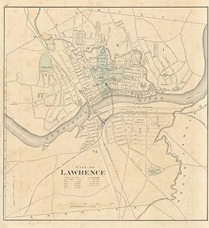
City of Lawrence
Ańo de publicación: 1871
Librería: Antiqua Print Gallery, London, Reino Unido
Calificación del vendedor: 4 de 5 estrellas
Mapa
EUR 50,79
EUR 11,47 shipping
Se envía de Reino Unido a Estados Unidos de AmericaCantidad disponible: 1 disponibles
Ańadir al carritoCondición: Fair. City of Lawrence, Massachusetts. Town plan. WALLING & GRAY 1871 old map. Antique hand coloured city plan; Henry Francis Walling & Ormando Willis Gray (1871). 36.0 x 33.0cm, 14.25 x 13 inches. Condition: Fair: No right margin (image incomplete: a small part of the print may be missing compared to that shown in the scan); Pencil marks. There is another map printed on the reverse side.
-
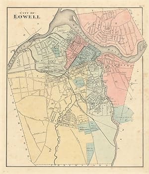
City of Lowell. Reduced by permission from the large Map by R.W. Baker
Ańo de publicación: 1871
Librería: Antiqua Print Gallery, London, Reino Unido
Calificación del vendedor: 4 de 5 estrellas
Mapa
EUR 50,79
EUR 11,47 shipping
Se envía de Reino Unido a Estados Unidos de AmericaCantidad disponible: 1 disponibles
Ańadir al carritoCondición: Good. City of Lowell, Massachusetts. Town plan. BAKER, WALLING & GRAY 1871 old map. Antique hand coloured city plan; Henry Francis Walling & Ormando Willis Gray (1871). 38.0 x 32.5cm, 14.75 x 12.75 inches. Condition: Good. Light spotting. There is another map printed on the reverse side.
-
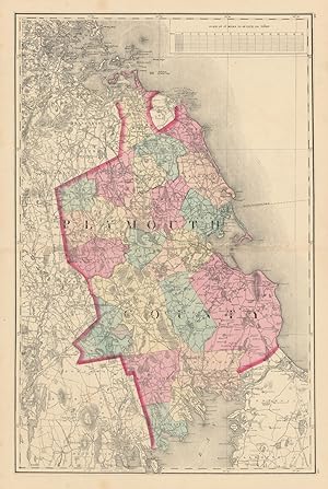
Plymouth County
Ańo de publicación: 1871
Librería: Antiqua Print Gallery, London, Reino Unido
Calificación del vendedor: 4 de 5 estrellas
Mapa
EUR 50,79
EUR 11,47 shipping
Se envía de Reino Unido a Estados Unidos de AmericaCantidad disponible: 1 disponibles
Ańadir al carritoCondición: Good. Plymouth County, Massachusetts. WALLING & GRAY 1871 old antique map plan chart. Antique hand coloured county map; Henry Francis Walling & Ormando Willis Gray (1871). 61.5 x 41.5cm, 24.25 x 16.25 inches; this is a folding map. Condition: Good. Spot. There is nothing printed on the reverse side, which is plain.
-
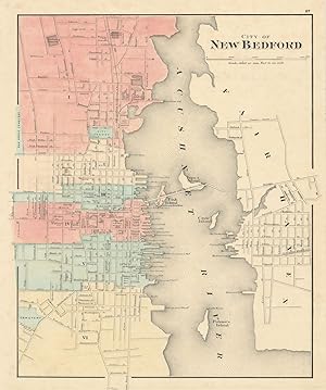
City of New Bedford
Ańo de publicación: 1871
Librería: Antiqua Print Gallery, London, Reino Unido
Calificación del vendedor: 4 de 5 estrellas
Mapa
EUR 50,79
EUR 11,47 shipping
Se envía de Reino Unido a Estados Unidos de AmericaCantidad disponible: 1 disponibles
Ańadir al carritoCondición: Good. City of New Bedford, Massachusetts. Town plan. WALLING & GRAY 1871 old map. Antique hand coloured city plan; Henry Francis Walling & Ormando Willis Gray (1871). 39.5 x 33.0cm, 15.5 x 13 inches. Condition: Good. Repaired marginal tear. There is another map printed on the reverse side.
-
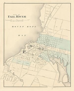
City of Fall River
Ańo de publicación: 1871
Librería: Antiqua Print Gallery, London, Reino Unido
Calificación del vendedor: 4 de 5 estrellas
Mapa
EUR 54,33
EUR 11,47 shipping
Se envía de Reino Unido a Estados Unidos de AmericaCantidad disponible: 1 disponibles
Ańadir al carritoCondición: Good. City of Fall River, Massachusetts. Town plan. WALLING & GRAY 1871 old map. Antique hand coloured city plan; Henry Francis Walling & Ormando Willis Gray (1871). 39.0 x 32.0cm, 15.25 x 12.5 inches. Condition: Good. There is another map printed on the reverse side.
-
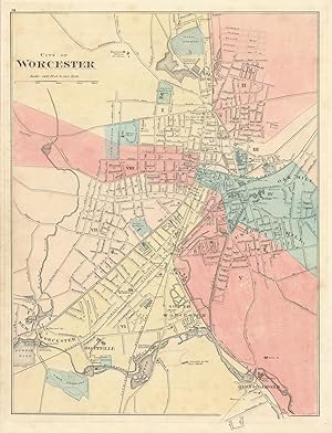
City of Worcester
Ańo de publicación: 1871
Librería: Antiqua Print Gallery, London, Reino Unido
Calificación del vendedor: 4 de 5 estrellas
Mapa
EUR 55,51
EUR 11,47 shipping
Se envía de Reino Unido a Estados Unidos de AmericaCantidad disponible: 1 disponibles
Ańadir al carritoCondición: Good. City of Worcester, Massachusetts. Town plan. WALLING & GRAY 1871 old map. Antique hand coloured city plan; Henry Francis Walling & Ormando Willis Gray (1871). 42.5 x 32.5cm, 16.5 x 12.75 inches. Condition: Good. Light spotting. There is another map printed on the reverse side.
-
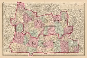
Hampshire County & Hampden County
Ańo de publicación: 1871
Librería: Antiqua Print Gallery, London, Reino Unido
Calificación del vendedor: 4 de 5 estrellas
Mapa
EUR 55,51
EUR 11,47 shipping
Se envía de Reino Unido a Estados Unidos de AmericaCantidad disponible: 1 disponibles
Ańadir al carritoCondición: Good. Hampshire County & Hampden County, Massachusetts. WALLING & GRAY 1871 old map. Antique hand coloured county map; Henry Francis Walling & Ormando Willis Gray (1871). 41.0 x 62.0cm, 16.25 x 24.25 inches; this is a folding map. Condition: Good. There is nothing printed on the reverse side, which is plain.
-
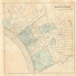
City of Springfield
Ańo de publicación: 1871
Librería: Antiqua Print Gallery, London, Reino Unido
Calificación del vendedor: 4 de 5 estrellas
Mapa
EUR 55,51
EUR 11,47 shipping
Se envía de Reino Unido a Estados Unidos de AmericaCantidad disponible: 1 disponibles
Ańadir al carritoCondición: Fair. City of Springfield, Massachusetts. Town plan. WALLING & GRAY 1871 old map. Antique hand coloured city plan; Henry Francis Walling & Ormando Willis Gray (1871). 32.0 x 32.0cm, 12.75 x 12.5 inches. Condition: Fair: Spotting. There is another map printed on the reverse side.
-
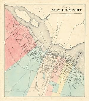
City of Newburyport
Ańo de publicación: 1871
Librería: Antiqua Print Gallery, London, Reino Unido
Calificación del vendedor: 4 de 5 estrellas
Mapa
EUR 57,87
EUR 11,47 shipping
Se envía de Reino Unido a Estados Unidos de AmericaCantidad disponible: 1 disponibles
Ańadir al carritoCondición: Fair. City of Newburyport, Massachusetts. Town plan. WALLING & GRAY 1871 old map. Antique hand coloured city plan; Henry Francis Walling & Ormando Willis Gray (1871). 31.0 x 27.5cm, 12.25 x 10.75 inches. Condition: Fair: Pencil marks. Light spotting. There is another map printed on the reverse side.
-
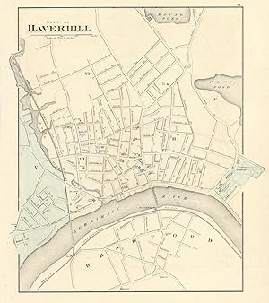
City of Haverhill
Ańo de publicación: 1871
Librería: Antiqua Print Gallery, London, Reino Unido
Calificación del vendedor: 4 de 5 estrellas
Mapa
EUR 57,87
EUR 11,47 shipping
Se envía de Reino Unido a Estados Unidos de AmericaCantidad disponible: 1 disponibles
Ańadir al carritoCondición: Fair. City of Haverhill, Massachusetts. Town plan. WALLING & GRAY 1871 old map. Antique hand coloured city plan; Henry Francis Walling & Ormando Willis Gray (1871). 36.5 x 32.5cm, 14.5 x 12.75 inches. Condition: Fair: Pencil marks. There is another map printed on the reverse side.
-
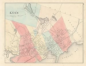
City of Lynn
Ańo de publicación: 1871
Librería: Antiqua Print Gallery, London, Reino Unido
Calificación del vendedor: 4 de 5 estrellas
Mapa
EUR 57,87
EUR 11,47 shipping
Se envía de Reino Unido a Estados Unidos de AmericaCantidad disponible: 1 disponibles
Ańadir al carritoCondición: Fair. City of Lynn, Massachusetts. Town plan. WALLING & GRAY 1871 old antique map. Antique hand coloured city plan; Henry Francis Walling & Ormando Willis Gray (1871). 30.0 x 39.5cm, 11.75 x 15.5 inches. Condition: Fair: Pencil marks. Light spotting. There is another map printed on the reverse side.
-
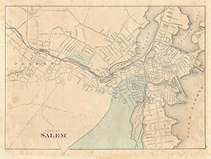
City of Salem
Ańo de publicación: 1871
Librería: Antiqua Print Gallery, London, Reino Unido
Calificación del vendedor: 4 de 5 estrellas
Mapa
EUR 57,87
EUR 11,47 shipping
Se envía de Reino Unido a Estados Unidos de AmericaCantidad disponible: 1 disponibles
Ańadir al carritoCondición: Fair. City of Salem, Massachusetts. Town plan. WALLING & GRAY 1871 old antique map. Antique hand coloured city plan; Henry Francis Walling & Ormando Willis Gray (1871). 30.5 x 41.0cm, 12 x 16 inches. Condition: Fair: Spotting; Pencil marks. There is another map printed on the reverse side.
-
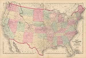
Map of the United States and territories. H.F. Walling & O.W. Gray, Boston, 1871.
Ańo de publicación: 1871
Librería: Antiqua Print Gallery, London, Reino Unido
Calificación del vendedor: 4 de 5 estrellas
Mapa
EUR 57,87
EUR 11,47 shipping
Se envía de Reino Unido a Estados Unidos de AmericaCantidad disponible: 1 disponibles
Ańadir al carritoCondición: Good. Map of the United States and territories by Walling & Gray 1871 old. Antique hand coloured map; Henry Francis Walling & Ormando Willis Gray (1871). 43.0 x 64.5cm, 17 x 25.25 inches; this is a folding map. Condition: Good. Repaired marginal tear. There is nothing printed on the reverse side, which is plain.
-

Chicago
Publicado por M. R. Brown, Philadelphia, 1876
Librería: mediumraremaps.com, Franklin, TN, Estados Unidos de America
Calificación del vendedor: 1 de 5 estrellas

EUR 131,49
EUR 5,11 shipping
Se envía dentro de Estados Unidos de AmericaCantidad disponible: 1 disponibles
Ańadir al carritoCondición: Very Good. Ormando Willis Gray Ilustrador. Beautifully composed map of Chicago 5 years after the fire. Outline color stands out. Infilled wash color identifies the wards of Chicago. Will make an excellent framed image of Chicago almost a century and one-half ago.
-

Nebraska
Publicado por Stedman, Brown & Lyon, Philadelphia, 1877
Librería: Argosy Book Store, ABAA, ILAB, New York, NY, Estados Unidos de America
Miembro de asociación: ABAA ILAB
Calificación del vendedor: 5 de 5 estrellas
EUR 131,49
EUR 5,11 shipping
Se envía dentro de Estados Unidos de AmericaCantidad disponible: 1 disponibles
Ańadir al carritounbound. Condición: very good(+). Map. Engraving with original hand coloring. Image measures 11.75" x 14.75". Nice map of Nebraska divided into counties and townships. Shows towns, waterways and railroads. In excellent condition with only a very small chip to lower left corner.
-

Missouri.
Publicado por Philadelphia: 1874, 1874
Librería: Peter Harrington. ABA/ ILAB., London, Reino Unido
Miembro de asociación: ABA ILAB PBFA
Calificación del vendedor: 5 de 5 estrellas
EUR 112,20
EUR 25,23 shipping
Se envía de Reino Unido a Estados Unidos de AmericaCantidad disponible: 1 disponibles
Ańadir al carritoA detailed plan of this mid - western state. Each county is coloured separately. There is a small inset plan of the vicinity of St. Louis - one of larger cities in the state. Published in 'Gray's Atlas of The United States'. Size: 370 x 440 mm. Original lithograph in colour. Very good condition.
-

The City of St. Louis Missouri. The City of New Orleans Louisiana.
Publicado por Philadelphia: 1874, 1874
Librería: Peter Harrington. ABA/ ILAB., London, Reino Unido
Miembro de asociación: ABA ILAB PBFA
Calificación del vendedor: 5 de 5 estrellas
EUR 112,20
EUR 25,23 shipping
Se envía de Reino Unido a Estados Unidos de AmericaCantidad disponible: 1 disponibles
Ańadir al carritoA pair of detailed plans of downtown St. Louis and New Orleans, both situated on the banks of the Mississippi River. The historic and famous French Quarter is prominent on the plan of New Orleans. Published in 'Gray's Atlas of The United States'. Size: 365 x435 mm. Original lithograph in colour. Very good condition.
-

Map of the City of Providence. (Map of the City of Hartford CT on verso)
Publicado por Philadelphia: 1875, 1875
Librería: Peter Harrington. ABA/ ILAB., London, Reino Unido
Miembro de asociación: ABA ILAB PBFA
Calificación del vendedor: 5 de 5 estrellas
EUR 112,20
EUR 25,23 shipping
Se envía de Reino Unido a Estados Unidos de AmericaCantidad disponible: 1 disponibles
Ańadir al carritoA very detailed and attractive plan of Providence - the capital of Rhode Island, the smallest state in The USA and situated at the mouth of the Providence River, at the head of Narragansett Bay. On the reverse of this map is a plan of Hartford, the capital of the state of Connecticut. Size:440 x360 mm. Original lithograph with colour. Very good condition.
-

Mexico.
Publicado por Philadelphia: 1873, 1873
Librería: Peter Harrington. ABA/ ILAB., London, Reino Unido
Miembro de asociación: ABA ILAB PBFA
Calificación del vendedor: 5 de 5 estrellas
EUR 147,63
EUR 25,23 shipping
Se envía de Reino Unido a Estados Unidos de AmericaCantidad disponible: 1 disponibles
Ańadir al carritoA comprehensive map of Mexico, taken from Gray's 'Atlas of the United States with General Maps of the World.' each individual county within the state is highlighted in a different colour. The map notes roads, railways, towns and cities, and some topographical detail. Inset maps of Mexico to Vera Cruz, and The Isthmus of Tehuantepec. On the reverse of the map are the state maps of New Mexico and Arizona. Size: 365 x 440 mm. Lithograph with original wash colour. Fine condition.
-

Pennsylvania.
Publicado por Philadelphia: 1873, 1873
Librería: Peter Harrington. ABA/ ILAB., London, Reino Unido
Miembro de asociación: ABA ILAB PBFA
Calificación del vendedor: 5 de 5 estrellas
EUR 177,16
EUR 25,23 shipping
Se envía de Reino Unido a Estados Unidos de AmericaCantidad disponible: 1 disponibles
Ańadir al carritoA very comprehensive map of the north eastern U.S. state of Pennsylvania, taken from Gray's 'Atlas of the United States.' each individual county within the state is highlighted in a different colour. The map notes roads, railways, towns and cities, and some topographical detail. It was one of the original thirteen states that founded the United States of America. Pennsylvania became the second state to ratify the U.S. Constitution on December 12th 1787, some five days after Delaware became the first. The state takes its name after the English Quaker, William Penn. Size: 440 x 715 mm. Lithograph with original colour. Hole to upper central fold, otherwise in good condition.