
Importe total (1 artículo artículos):
Destino del pedido:

geographia map (Más de 1.000 resultados)
Ir a los resultados principales
Filtros de búsqueda
Tipo de artículo
- Todos los tipos de productos
- Libros (576)
- Revistas y publicaciones (No hay ningún otro resultado que coincida con este filtro.)
- Cómics (No hay ningún otro resultado que coincida con este filtro.)
- Partituras (No hay ningún otro resultado que coincida con este filtro.)
- Arte, grabados y pósters (No hay ningún otro resultado que coincida con este filtro.)
- Fotografías (No hay ningún otro resultado que coincida con este filtro.)
- Mapas (512)
- Manuscritos y coleccionismo de papel (No hay ningún otro resultado que coincida con este filtro.)
Condición Más información
Encuadernación
Más atributos
- Primera edición (7)
- Firmado (No hay ningún otro resultado que coincida con este filtro.)
- Sobrecubierta (No hay ningún otro resultado que coincida con este filtro.)
- Con imágenes (1.059)
- No impresión bajo demanda (1.086)
Idioma (2)
Gastos de envío gratis
Ubicación del vendedor
Valoración de los vendedores
-

Geographia QuikFinder Manhattan New York Map
Idioma: Inglés
Publicado por Geographia Map Company, 2007
ISBN 10: 0884332861 ISBN 13: 9780884332862
Librería: HPB-Diamond, Dallas, TX, Estados Unidos de America
Calificación del vendedor: 5 de 5 estrellas

EUR 2,85
Envío por EUR 3,16
Se envía dentro de Estados Unidos de AmericaCantidad disponible: 1 disponibles
Ańadir al carritopamphlet. Condición: Very Good. Connecting readers with great books since 1972! Used books may not include companion materials, and may have some shelf wear or limited writing. We ship orders daily and Customer Service is our top priority!
-
Geographia QuikFinder Manhattan New York Map
Idioma: Inglés
Publicado por Geographia Map Company, 2007
ISBN 10: 0884332861 ISBN 13: 9780884332862
Librería: HPB-Emerald, Dallas, TX, Estados Unidos de America
Calificación del vendedor: 5 de 5 estrellas
EUR 3,46
Envío por EUR 3,16
Se envía dentro de Estados Unidos de AmericaCantidad disponible: 1 disponibles
Ańadir al carritopamphlet. Condición: Very Good. Connecting readers with great books since 1972! Used books may not include companion materials, and may have some shelf wear or limited writing. We ship orders daily and Customer Service is our top priority!
-

Geographia Ireland road atlas
Librería: Better World Books: West, Reno, NV, Estados Unidos de America
Calificación del vendedor: 5 de 5 estrellas
EUR 12,99
Gastos de envío gratis
Se envía dentro de Estados Unidos de AmericaCantidad disponible: 1 disponibles
Ańadir al carritoCondición: Good. Former library book; may include library markings. Used book that is in clean, average condition without any missing pages.
-

Geographia's five borough pocket atlas of New York City
Librería: HPB-Diamond, Dallas, TX, Estados Unidos de America
Calificación del vendedor: 5 de 5 estrellas
EUR 11,23
Envío por EUR 3,16
Se envía dentro de Estados Unidos de AmericaCantidad disponible: 1 disponibles
Ańadir al carritohardcover. Condición: Very Good. Connecting readers with great books since 1972! Used books may not include companion materials, and may have some shelf wear or limited writing. We ship orders daily and Customer Service is our top priority!
-

Geographia QuikFinder: New York City - Manhattan
Idioma: Inglés
Publicado por Geographia Map Company, 2002
ISBN 10: 0884332500 ISBN 13: 9780884332503
Librería: Wonder Book, Frederick, MD, Estados Unidos de America
Miembro de asociación: ABAA ILAB
Calificación del vendedor: 5 de 5 estrellas
EUR 10,81
Gastos de envío gratis
Se envía dentro de Estados Unidos de AmericaCantidad disponible: 1 disponibles
Ańadir al carritoCondición: Very Good. Very Good condition. (map, new york, manhattan) A copy that may have a few cosmetic defects. May also contain a few markings such as an owner's name, short gifter's inscription or light stamp.
-

THE HANDY WORLD ATLAS
Publicado por perma book,, 1950
Librería: GRAHAM HOLROYD, BOOKS, Webster, NY, Estados Unidos de America
Calificación del vendedor: 5 de 5 estrellas
Original o primera edición
EUR 2,60
Envío por EUR 5,85
Se envía dentro de Estados Unidos de AmericaCantidad disponible: 1 disponibles
Ańadir al carritoPaperback. ORIGINAL first edition. 070, very good , creases (ILLUSTRATED / 131 MAPS), paperback,
-
Geographia's five borough pocket atlas of New York City
Librería: Bingo Books 2, Vancouver, WA, Estados Unidos de America
Calificación del vendedor: 5 de 5 estrellas
EUR 12,14
Envío por EUR 5,30
Se envía dentro de Estados Unidos de AmericaCantidad disponible: 1 disponibles
Ańadir al carritoSoft cover. Condición: Very Good. 2nd Edition. SOFT COVER,RING BINDING, IN VERY GOOD CONDITION.
-
THE HANDY WORLD ATLAS
Publicado por perma book,, 1950
Librería: GRAHAM HOLROYD, BOOKS, Webster, NY, Estados Unidos de America
Calificación del vendedor: 5 de 5 estrellas
Original o primera edición
EUR 4,34
Envío por EUR 5,85
Se envía dentro de Estados Unidos de AmericaCantidad disponible: 1 disponibles
Ańadir al carritoPaperback. ORIGINAL first edition. 070, very good -fine, , reading crease (ILLUSTRATED / 131 MAPS), paperback,
-
Ireland Motoring Atlas
Librería: medimops, Berlin, Alemania
Calificación del vendedor: 5 de 5 estrellas
EUR 4,57
Envío por EUR 15,00
Se envía de Alemania a Estados Unidos de AmericaCantidad disponible: 1 disponibles
Ańadir al carritoCondición: good. Befriedigend/Good: Durchschnittlich erhaltenes Buch bzw. Schutzumschlag mit Gebrauchsspuren, aber vollständigen Seiten. / Describes the average WORN book or dust jacket that has all the pages present.
-
THE HANDY WORLD ATLAS
Publicado por perma book,, 1950
Librería: GRAHAM HOLROYD, BOOKS, Webster, NY, Estados Unidos de America
Calificación del vendedor: 5 de 5 estrellas
Original o primera edición
EUR 6,07
Envío por EUR 5,85
Se envía dentro de Estados Unidos de AmericaCantidad disponible: 1 disponibles
Ańadir al carritoPaperback. ORIGINAL first edition. 070, almost near fine, (ILLUSTRATED / 131 MAPS), paperback,
-
THE HANDY WORLD ATLAS
Publicado por perma book,, 1950
Librería: GRAHAM HOLROYD, BOOKS, Webster, NY, Estados Unidos de America
Calificación del vendedor: 5 de 5 estrellas
Original o primera edición
EUR 7,81
Envío por EUR 5,85
Se envía dentro de Estados Unidos de AmericaCantidad disponible: 1 disponibles
Ańadir al carritoPaperback. ORIGINAL first edition. 070, near fine, unread (ILLUSTRATED / 131 MAPS), paperback,
-

Geographia Westchester/Putnam Counties Streetatlas
Idioma: Inglés
Publicado por Geographia map company, 2002
ISBN 10: 0884332454 ISBN 13: 9780884332459
Librería: Rob the Book Man, Vancouver, WA, Estados Unidos de America
Calificación del vendedor: 5 de 5 estrellas
EUR 17,13
Envío por EUR 5,89
Se envía dentro de Estados Unidos de AmericaCantidad disponible: 1 disponibles
Ańadir al carritoSoft cover. Condición: Good. Large spiral paperback in good condition.
-
Geographia Street Atlas of Westchester and Putnam Counties, New York
Publicado por Geographia Map Co., Inc., Jersey City, NJ, 1980
Librería: Prairie Creek Books LLC., Torrington, WY, Estados Unidos de America
Calificación del vendedor: 4 de 5 estrellas

Original o primera edición
EUR 10,41
Envío por EUR 4,21
Se envía dentro de Estados Unidos de AmericaCantidad disponible: 1 disponibles
Ańadir al carritoSoft cover. Condición: Very Good. No Jacket. 1st Edition. VG/none, color illustrated stiff paper wraps, wire-bound, 95pp. Interior clean, no marks, binding firm no torn tabs. Shelf rubbing to wraps, no chips or tears, corners slightly rubbed. Some map pages are colorized some are black and white.
-

Westchester; Putnam counties street atlas
Publicado por Geographia Map Co., Weehawken, N.J., 1995
Librería: CorgiPack, Fulton, NY, Estados Unidos de America
Calificación del vendedor: 4 de 5 estrellas
EUR 17,31
Gastos de envío gratis
Se envía dentro de Estados Unidos de AmericaCantidad disponible: 1 disponibles
Ańadir al carritoWire spiral bound. Condición: Good. Special Laminated edition. Wear to covers. Text free of highlighting and writing. Revised edition of: Geographia's street atlas of Westchester and Putnam counties, New York. 4th ed. 1987 Includes zip code and highway maps, handy community listing and indexes.
-
Famous Guide to New York
Publicado por Geographia., 1965
Librería: Basement Seller 101, Cincinnati, OH, Estados Unidos de America
Calificación del vendedor: 5 de 5 estrellas
EUR 13,84
Envío por EUR 4,21
Se envía dentro de Estados Unidos de AmericaCantidad disponible: 1 disponibles
Ańadir al carritoPaperback. Condición: Very Good.
-

Kent to Cornwall. South Coast Route Planner. Guide to Places of Interest. Easy Read Holiday Planning Map. Kent to Cornwall on One Sheet. Fold Out Map.
Librería: J J Basset Books, bassettbooks, bookfarm.co.uk, Peter Tavy, Reino Unido
Calificación del vendedor: 2 de 5 estrellas

EUR 5,93
Envío por EUR 23,03
Se envía de Reino Unido a Estados Unidos de AmericaCantidad disponible: 1 disponibles
Ańadir al carritoFold Out Map. Condición: VERY GOOD ( AVERAGE). No Jacket. Map Illustrations Throughout. Ilustrador. This is lthe first edition of this edition. This book will be POSTED AT OUR STANDARD RATES FULLY INSURED (UK) ONLY . Please email for further details. OFFERED FOR SALE BY A FULL-TIME STOCKHOLDING CAREER BOOKSELLER WHO TELLS YOU WHO THEY ARE AND WHAT THEIR TELEPHONE AND ADDRESS CONTACT DETAILS ARE! POSTED AT OUR STANDARD RATES FULLY INSURED! (UK ONLY). FEEL FREE TO E-MAIL FOR PHOTOGRAPHS AND FURTHER DETAILS. Size: 8vo - over 7ľ" - 9ľ". Not Signed or Inscribed.
-
Geographia Large Scale Road Map of: Gloucestershire.
Idioma: Inglés
Publicado por Geographia Ltd., London, UK.
Librería: J J Basset Books, bassettbooks, bookfarm.co.uk, Peter Tavy, Reino Unido
Calificación del vendedor: 2 de 5 estrellas
EUR 7,12
Envío por EUR 23,03
Se envía de Reino Unido a Estados Unidos de AmericaCantidad disponible: 1 disponibles
Ańadir al carritoBlue Decorated Cloth. Condición: VERY GOOD ( AVERAGE). No Jacket. Map Mounted on Cloth. Ilustrador. The rear side of map has some foxing and brown stain marks.This book will be POSTED AT OUR STANDARD RATES FULLY INSURED (UK) ONLY . Please email for further details. OFFERED FOR SALE BY A FULL-TIME STOCKHOLDING CAREER BOOKSELLER WHO TELLS YOU WHO THEY ARE AND WHAT THEIR TELEPHONE AND ADDRESS CONTACT DETAILS ARE! POSTED AT OUR STANDARD RATES FULLY INSURED! (UK ONLY). FEEL FREE TO E-MAIL FOR PHOTOGRAPHS AND FURTHER DETAILS. Size: 12mo - over 6ľ" - 7ľ". Not Signed or Inscribed.
-
Pictorial Souvenir Of New York For New Yorkers and Visitors
Publicado por NY: Geographia Map Co., 1944, 1944
Librería: WellRead Books, Shamong, NJ, Estados Unidos de America
Miembro de asociación: IOBA
Calificación del vendedor: 5 de 5 estrellas
EUR 13,01
Envío por EUR 6,74
Se envía dentro de Estados Unidos de AmericaCantidad disponible: 1 disponibles
Ańadir al carritoSm. 4to; stiff pictorial wraps, softcover; 64 pages; over 160 black and white photographic illustrations and a map; gift inscription on first page and in lightly edgeworn wraps with a tear that is taped on back wrap else good.
-

Essex County Streetmap
Publicado por GEOGRAPHIA MAP CO INC
ISBN 10: 0884333493 ISBN 13: 9780884333494
Librería: Princeton Antiques Bookshop / Ruffolo Enterprises, Atlantic City, NJ, Estados Unidos de America
Calificación del vendedor: 4 de 5 estrellas
EUR 17,35
Envío por EUR 5,05
Se envía dentro de Estados Unidos de AmericaCantidad disponible: 1 disponibles
Ańadir al carritoPAPER BACK WHITE. Condición: VERY GOOD. General wear, clean, no markings, colored folded map, color coded highways, small grids for easy street finding, zip codes DATE PUBLISHED: EDITION:
-
New Edition Little Red Book The Latest Complete Street Guide to new York Manhattan & Bronx with detailed map
Publicado por Geographia Map. CO. INC., 1963
Librería: Robinson Street Books, IOBA, Binghamton, NY, Estados Unidos de America
Miembro de asociación: IOBA
Calificación del vendedor: 4 de 5 estrellas
EUR 15,18
Envío por EUR 8,00
Se envía dentro de Estados Unidos de AmericaCantidad disponible: 1 disponibles
Ańadir al carritomass market paperback. Condición: acceptable; used. Prompt Shipment, shipped in Boxes, Tracking PROVIDED16mo; 160 pages; acceptable mass market paperback; nicks and chips to cover edges; tips bumped and chips; scuff and chip to face cover and spine head area; some faint tanning; crease to cover; faint stain back few pages; otherwise clean pages; prompt shipping with tracking.
-
5 borough New York City street atlas.
Publicado por Geographia Map Company.
Librería: Wonder Book, Frederick, MD, Estados Unidos de America
Miembro de asociación: ABAA ILAB
Calificación del vendedor: 5 de 5 estrellas
EUR 17,31
Gastos de envío gratis
Se envía dentro de Estados Unidos de AmericaCantidad disponible: 1 disponibles
Ańadir al carritoCondición: Good. Good condition. (New York City, Street Maps) A copy that has been read but remains intact. May contain markings such as bookplates, stamps, limited notes and highlighting, or a few light stains.
-
The Authentic Map of the United States: Double-Sided, with Gazetteer Index
Idioma: Inglés
Publicado por Geographia Map Co. Inc., 1945
Librería: Yesterday's Muse, ABAA, ILAB, IOBA, Webster, NY, Estados Unidos de America
Miembro de asociación: ABAA ILAB IOBA
Calificación del vendedor: 5 de 5 estrellas
EUR 27,75
Gastos de envío gratis
Se envía dentro de Estados Unidos de AmericaCantidad disponible: 1 disponibles
Ańadir al carritoSingle Sheet. Condición: Very Good. 1940s printing based on publisher address. A few minor splits at intersections of folds with minimal loss. 1945 Single Sheet. 41 x 27. A large color map with a detailed gazetteer index of population figures for all locations with 2000 or more inhabitants, legend of railroad abbreviations, and a catalog of other maps available from the same company.
-
Geographia New York City 5 Borough Streetatlas Pathfinder Edition
Publicado por Geographia Map Company
Librería: Wonder Book, Frederick, MD, Estados Unidos de America
Miembro de asociación: ABAA ILAB
Calificación del vendedor: 5 de 5 estrellas
EUR 19,05
Gastos de envío gratis
Se envía dentro de Estados Unidos de AmericaCantidad disponible: 1 disponibles
Ańadir al carritoCondición: Good. Good condition. Pathfinder Edition. Large Print edition. ISBN 0884332594. (new york, street map, city map) A copy that has been read but remains intact. May contain markings such as bookplates, stamps, limited notes and highlighting, or a few light stains.
-
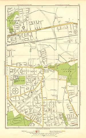
Chadwell Heath
Librería: Antiqua Print Gallery, London, Reino Unido
Calificación del vendedor: 5 de 5 estrellas
EUR 4,16
Envío por EUR 11,52
Se envía de Reino Unido a Estados Unidos de AmericaCantidad disponible: 6 disponibles
Ańadir al carrito -

Key to Sectional Maps
Librería: Antiqua Print Gallery, London, Reino Unido
Calificación del vendedor: 4 de 5 estrellas
EUR 4,74
Envío por EUR 11,52
Se envía de Reino Unido a Estados Unidos de AmericaCantidad disponible: 1 disponibles
Ańadir al carrito -
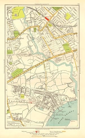
Barking, Beckton, Cyprus, New Beckton , Wall End
Ańo de publicación: 1937
Librería: Antiqua Print Gallery, London, Reino Unido
Calificación del vendedor: 4 de 5 estrellas
Mapa
EUR 4,74
Envío por EUR 11,52
Se envía de Reino Unido a Estados Unidos de AmericaCantidad disponible: 6 disponibles
Ańadir al carritoCondición: Good. LONDON. Barking Beckton Cyprus New Beckton Wall End 1937 old vintage map chart. Colour vintage street atlas map; The Geographia map company (1937). 30.5 x 18.5cm, 12 x 7.25 inches. Condition: Good. There is another map printed on the reverse side of this map. The paper is thick, and the map on the reverse side does not show through the paper. Map section #66 This map is one section from a 1937 Street Atlas of Greater London. This section of the map depicts the following suburbs in 1937: Barking,Beckton,Cyprus,New Beckton ,Wall End The maps in this series show London during the rapid interwar suburban expansion. Many areas shown in the outer suburbs as undeveloped land on these maps are now built up. Less frequently, some maps indicate housing developments proposed in 1937 but which were never built on land which is still undeveloped, or which has been built up according to a different street layout from that shown. The inner London maps in this series show London before the damage inflicted by the Blitz during World War 2 and the subsequent redevelopment of the 1950's and 1960's. These maps predate the construction of any motorways (the M1 sections into London having opened between 1966-1977), many major roads, and other post-war urban traffic schemes. The elevated sections of many major roads were constructed after the second world war; for example, the maps predate the construction of the Westway and elevated sections of the A4; the Western Avenue is shown on map sections #142 & #143 as proposed or under construction to the west of Northolt Aerodrome. The London docklands are shown at the height of their scale and glory, a network of large docks and railway lines. The last dock to be built had been completed in 1921. The prosperity of the docklands continued until the advent of containerisation 1960's, whereafter they remained derelict until redevelopment commenced in the early 1980's, centred around the area now known as Canary Wharf These maps show a number of now disappeared features, such as aerodromes which have since disappeared or changed their use, the Brooklands motor racing circuit (shown on map section #157, 2 years before it hosted its last race in 1939), and railways which are now disused. LHR is shown on map section #150 as the modest "Great West Aerodrome"; the original Heathrow Hall is also depicted on this map. The airport at that time was used for aircraft assembly and testing, with Croydon Airport (shown on map sections #163 and #164) being the main airport used for commercial flights.
-
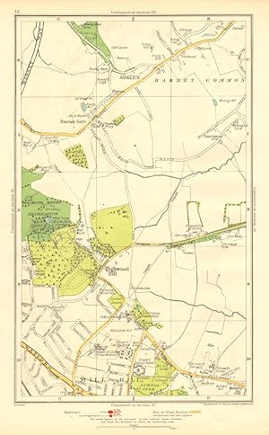
Arkley, Barnet Gate, Highwood Hill, Mill Hill
Ańo de publicación: 1937
Librería: Antiqua Print Gallery, London, Reino Unido
Calificación del vendedor: 4 de 5 estrellas
Mapa
EUR 4,74
Envío por EUR 11,52
Se envía de Reino Unido a Estados Unidos de AmericaCantidad disponible: 9 disponibles
Ańadir al carritoCondición: Good. LONDON. Arkley Barnet Gate Highwood Hill Mill Hill 1937 old vintage map chart. Colour vintage street atlas map; The Geographia map company (1937). 30.5 x 18.5cm, 12 x 7.25 inches. Condition: Good. There is another map printed on the reverse side of this map. The paper is thick, and the map on the reverse side does not show through the paper. Map section #13 This map is one section from a 1937 Street Atlas of Greater London. This section of the map depicts the following suburbs in 1937: Arkley,Barnet Gate,Highwood Hill,Mill Hill The maps in this series show London during the rapid interwar suburban expansion. Many areas shown in the outer suburbs as undeveloped land on these maps are now built up. Less frequently, some maps indicate housing developments proposed in 1937 but which were never built on land which is still undeveloped, or which has been built up according to a different street layout from that shown. The inner London maps in this series show London before the damage inflicted by the Blitz during World War 2 and the subsequent redevelopment of the 1950's and 1960's. These maps predate the construction of any motorways (the M1 sections into London having opened between 1966-1977), many major roads, and other post-war urban traffic schemes. The elevated sections of many major roads were constructed after the second world war; for example, the maps predate the construction of the Westway and elevated sections of the A4; the Western Avenue is shown on map sections #142 & #143 as proposed or under construction to the west of Northolt Aerodrome. The London docklands are shown at the height of their scale and glory, a network of large docks and railway lines. The last dock to be built had been completed in 1921. The prosperity of the docklands continued until the advent of containerisation 1960's, whereafter they remained derelict until redevelopment commenced in the early 1980's, centred around the area now known as Canary Wharf These maps show a number of now disappeared features, such as aerodromes which have since disappeared or changed their use, the Brooklands motor racing circuit (shown on map section #157, 2 years before it hosted its last race in 1939), and railways which are now disused. LHR is shown on map section #150 as the modest "Great West Aerodrome"; the original Heathrow Hall is also depicted on this map. The airport at that time was used for aircraft assembly and testing, with Croydon Airport (shown on map sections #163 and #164) being the main airport used for commercial flights.
-

Map Showing Museums Art Galleries Public Buildings Monuments Etc
Librería: Antiqua Print Gallery, London, Reino Unido
Calificación del vendedor: 4 de 5 estrellas
EUR 4,74
Envío por EUR 11,52
Se envía de Reino Unido a Estados Unidos de AmericaCantidad disponible: 1 disponibles
Ańadir al carrito -

Map Showing Museums, Art Galleries, Public Buildings, Monuments Etc
Librería: Antiqua Print Gallery, London, Reino Unido
Calificación del vendedor: 4 de 5 estrellas
EUR 4,74
Envío por EUR 11,52
Se envía de Reino Unido a Estados Unidos de AmericaCantidad disponible: 2 disponibles
Ańadir al carrito -

Barnet, Bentley Heath, Dancers Hill, Ganwick Corner, Kitt's End, Monken Hadley
Ańo de publicación: 1937
Librería: Antiqua Print Gallery, London, Reino Unido
Calificación del vendedor: 4 de 5 estrellas
Mapa
EUR 4,74
Envío por EUR 11,52
Se envía de Reino Unido a Estados Unidos de AmericaCantidad disponible: 14 disponibles
Ańadir al carritoCondición: Good. BARNET. Monken Hadley Wrotham Park Kitts End Dancer's Hill Ganwick Cnr 1937 map. Colour vintage street atlas map; The Geographia map company (1937). 30.5 x 18.5cm, 12 x 7.25 inches. Condition: Good. There is another map printed on the reverse side of this map. The paper is thick, and the map on the reverse side does not show through the paper. Map section #3 This map is one section from a 1937 Street Atlas of Greater London. This section of the map depicts the following suburbs in 1937: Barnet,Bentley Heath,Dancers Hill,Ganwick Corner,Kitt's End,Monken Hadley The maps in this series show London during the rapid interwar suburban expansion. Many areas shown in the outer suburbs as undeveloped land on these maps are now built up. Less frequently, some maps indicate housing developments proposed in 1937 but which were never built on land which is still undeveloped, or which has been built up according to a different street layout from that shown. The inner London maps in this series show London before the damage inflicted by the Blitz during World War 2 and the subsequent redevelopment of the 1950's and 1960's. These maps predate the construction of any motorways (the M1 sections into London having opened between 1966-1977), many major roads, and other post-war urban traffic schemes. The elevated sections of many major roads were constructed after the second world war; for example, the maps predate the construction of the Westway and elevated sections of the A4; the Western Avenue is shown on map sections #142 & #143 as proposed or under construction to the west of Northolt Aerodrome. The London docklands are shown at the height of their scale and glory, a network of large docks and railway lines. The last dock to be built had been completed in 1921. The prosperity of the docklands continued until the advent of containerisation 1960's, whereafter they remained derelict until redevelopment commenced in the early 1980's, centred around the area now known as Canary Wharf These maps show a number of now disappeared features, such as aerodromes which have since disappeared or changed their use, the Brooklands motor racing circuit (shown on map section #157, 2 years before it hosted its last race in 1939), and railways which are now disused. LHR is shown on map section #150 as the modest "Great West Aerodrome"; the original Heathrow Hall is also depicted on this map. The airport at that time was used for aircraft assembly and testing, with Croydon Airport (shown on map sections #163 and #164) being the main airport used for commercial flights.


