Engraved rapkin (40 resultados)
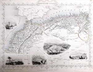
steal engraving / Grenzcolorierter Stahlstich Northern Africa. Mit weiteren 5 Bildstahlstichen 1)Mogador. 2) Marocco. 3) Constantine. 4) Algiers. 5)Tunis.
Martin, R.M. (Hrsg.) - Winkles, H. (ill) /Greatbach,G. (engraved) / Rapkin, John (The Map Drawn & Engraved by):
Idioma: Inglés
Editorial: The London Printing and Publishing Company. o.J. [ca 1850], 1850
- Tapa blanda
- Primera edición
Librería: Antiquariat Carl Wegner, Berlin, B, AlemaniaAntiquariat Carl Wegner
Contactar con el vendedorVendedor de 5 estrellasMiembro de asociación: GIAQ
Condición: Usado
EUR 17,70
Envío por EUR 9,00Se envía de Alemania a Estados Unidos de AmericaCantidad disponible: 1 disponibles
Softcover. Blattgröße 27x36 cm, Stichgröße 21 x 30 cm, mittig längs gefaltet. Die Tafel mit floraler Rahmung, eingezeichneten Längen- und Breitengraden und Maßstabsangabe. Das Blatt an den Rändern und in der Querfalte leicht lichtrandig und fingerfleckig, an der linken unteren Ecke eine Faltstelle, sonst schönes Exemplar. --- In… english language. Good condition. Die Tafel beschriftet mit der Ziffer 61. Wahrscheinlich die entsprechende Tafel aus dem Werk von John Tallis: Illustrated atlas and modern history of the world. -- Zu dekorativen Zwecken, zum Rahmen geeignet. Weitere Karten aus dem gleichen Werk vorhanden. "John Rapkin was a mapmaker who was concerned with the aesthetic value of his work as well as cartographic content. His fine maps are distinguished by the trademark decorative borders, vignettes and title displays. Rapkin worked in close association with the equally respected publisher John Tallis. The publishing rights of many of the maps passed to The London Printing and Publishing Company circa 1850. " -- Bitte Portokosten außerhalb EU erfragen! / Please ask for postage costs outside EU! / S ' il vous plait demander des frais de port en dehors de l ' UE! // Bitte beachten Sie auch unsere Fotos! / Please also note our photos! / Veuillez noter nos photos -- Ob Sonnenschein oder warmer Regen: mit einem interessanten Buch kommen Sie immer gut durch den Tag. -- Wir kaufen Ihre werthaltigen Bücher! GM25-502030.

The Battle of the Alma - Showing the English, French , Russian and Turkish Forces - an Original Antique Engraved Map
THE BATTLE OF THE ALMA - an Original Hand Coloured Engraved Map
Idioma: Inglés
Librería: K Books Ltd ABA ILAB, York, YORKS, Reino UnidoK Books Ltd ABA ILAB
Contactar con el vendedorVendedor de 5 estrellasCondición: Usado - Bueno
EUR 24,04
Envío por EUR 22,76Se envía de Reino Unido a Estados Unidos de AmericaCantidad disponible: 1 disponibles
No Binding. Condición: Very Good. An original antique engraved map, printed circa 1860. Hand-colouring contemporary. Mounted and ready to frame. A fine opportunity to purchase an attractive and decorative map - The Battle of the Alma - Showing the English, French , Russian and Turkish Forces on the 19th and 20th September, 1854.… Lovley decoratively engraved frame. Engraved By J. Rapkin (ilustrador).
Idioma: Inglés
Editorial: The London Printing and Publishing Company, London
Librería: K Books Ltd ABA ILAB, York, YORKS, Reino UnidoK Books Ltd ABA ILAB
Contactar con el vendedorVendedor de 5 estrellasCondición: Usado - Bueno
EUR 54,10
Envío por EUR 22,76Se envía de Reino Unido a Estados Unidos de AmericaCantidad disponible: 1 disponibles
No Binding. Condición: Very Good. An original antique map of the Independent Tartary printed ca. 1850. Mounted and ready to frame. Contemporary colouring in outline with hand-coloured vignettes of Tartars, Tartar life etc etc. In excellent condition, decorative and impressive. *Excellent map of Central Asia. Engraved By J Rapkin… (ilustrador).
 Más imágenes
Idioma: Inglés
Editorial: H. Lamb & Son, Malvern
- Tapa dura
- Mapa
Librería: J. R. Young, Birmingham, Reino UnidoJ. R. Young
Contactar con el vendedorVendedor de 5 estrellasCondición: Usado - Aceptable
EUR 150,28
Envío por EUR 24,51Se envía de Reino Unido a Estados Unidos de AmericaCantidad disponible: 1 disponibles
Hardcover. Condición: Good. Partly coloured circular map on smooth closely-woven thin white fabric. No date (mid- to later-19th century). On square sheet of sides 42.5cm, folding up into 12 segments. In original green cloth binding 15x11cm, lined on inside with grey-green paper; covers with blindstamped decorations, front titled… in gilt. Map lightly spotted, blank verso also lightly dust-marked over one or two segments. Binding here & there a little faded, and damp-stained to a darker tone towards lower inner corner of front cover - nothing too disfiguring. Paper along inner hinge partly split. Binding holding and of decent appearance, map in good order. Overall condition GOOD.
Idioma: Inglés
Editorial: The London Printing and Publishing Company - Limited, London and New York, 1850
- Tapa dura
- Primera edición
Librería: Arroyo Seco Books, Pasadena, Member IOBA, Pasadena, CA, Estados Unidos de AmericaArroyo Seco Books, Pasadena, Member IOBA
Contactar con el vendedorVendedor de 4 estrellasMiembro de asociación: IOBA
Condición: Usado - Aceptable
EUR 535,87
Envío por EUR 6,99Se envía dentro de Estados Unidos de AmericaCantidad disponible: 1 disponibles
Half Leather. Condición: Good. First Edition Thus. Two Volumes, Three Quarter Leather. Volume 1: 944 Pp With 30 Uncolored Plates And One Colored Map "Mexico, California, And Texas: The Newly Discovered Gold Districts". Volume Ii: 784 Pp With Two Colored Maps Of Canada, And 22 Colored Plates, All With Yellow Borders And Nice Orig…inal Color Throughout. The Map Of Mexico And California, Tipped In But Neatly Loosened And Detached (Without Intention) And Usually Not Present, Has Nicely Detailed Illustrations Of The Ruins At Uxmal, Yucatan, Mexican Peasantry, And Gold Washing, And Outlines The Gold Districts Of The U S And Mexico In Yellow. No Date Of Publication Indicated But Presumably 1850. Bindings Poor, Three Of Four Boards Detached, Spines Perished, Boards Very Worn And Frayed, Deserving Of An Expensive Rebind. Contents Near Fine, Clean, Maps Perfectly Preserved. Volume I With Additional Illustrated Title Page, Showing Penn's Treaty, Painted By Benjamin West And Here Engraved By J. Rogers. This Greatly Enlarged Fourth Edition With The Colored California Gold Map Is Uncommon, About 7 Holdings Shown In Worldcat; It Is Not Listed In Carl Wheat's "The Maps Of The California Gold Region 1848 - 1857", Nor In The Addendum To The 1997 Martino Reprint Of That Book. 3 Colored Maps, 22 Colored Plates, 30 Uncolored Plates (ilustrador).
 Más imágenes
Idioma: Inglés
Editorial: From the Montgomery Martin Illustrated Atlas, London, 1851
- Primera edición
- Mapa
Librería: Roz Hulse, Plymouth, DEVON, Reino UnidoRoz Hulse
Contactar con el vendedorVendedor de 5 estrellasCondición: Usado - Bueno
EUR 48,09
Envío por EUR 40,85Se envía de Reino Unido a Estados Unidos de AmericaCantidad disponible: 1 disponibles
No Binding. Condición: Very Good. 1st Edition. Tallis, John: Peru and Bolivia. London. [ca.1851]. From the Montgomery Martin Illustrated Atlas. Map engraved by Rapkin. Size approx 360 x 260mm. Original steel engraved map with original outline hand colouring. 4 vignettes include Lima, Potosi, Swimming Couriers of Peru. Decorative… Border. Single page unfolded map in good order, two faint fox marks in map area, printers imk mark on the sky of Potosi illustration. Associated text page of the Montgomery Martin Atlas included. A good Tallis Map. Map engraved by Rapkin. Illustrations H Warren (ilustrador).
 Más imágenes
Idioma: Inglés
Editorial: From the Montgomery Martin Illustrated Atlas., London, 1851
- Primera edición
- Mapa
Librería: Roz Hulse, Plymouth, DEVON, Reino UnidoRoz Hulse
Contactar con el vendedorVendedor de 5 estrellasCondición: Usado - Bueno
EUR 60,11
Envío por EUR 40,85Se envía de Reino Unido a Estados Unidos de AmericaCantidad disponible: 1 disponibles
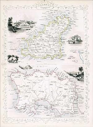
No Binding. Condición: Very Good. No Jacket. 1st Edition. Tallis, John: Channel Islands. London. [ca.1851]. From the Montgomery Martin Illustrated Atlas. Map engraved by Rapkin. Size approx 360 x 260mm. Original steel engraved map with original outline hand colouring. 5 vignettes include St Peters Port, Castle Cornet, Druidian A…lter near Lancresse, Mount Orgueil Castle and Jersey. Decorative border encloses 2 maps of the large islands of Jersey and Guernsey with an inset of the other islands. Single page unfolded map in excellent, clean condition. Associated text page of the Montgomery Martin Atlas included. A good Tallis Map. Map engraved by Rapkin. (ilustrador).
 Más imágenes
Idioma: Inglés
Editorial: From the Montgomery Martin Illustrated Atlas., London, 1851
- Primera edición
- Mapa
Librería: Roz Hulse, Plymouth, DEVON, Reino UnidoRoz Hulse
Contactar con el vendedorVendedor de 5 estrellasCondición: Usado - Bueno
EUR 72,13
Envío por EUR 40,85Se envía de Reino Unido a Estados Unidos de AmericaCantidad disponible: 1 disponibles
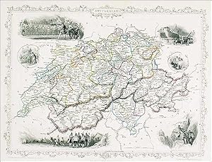
No Binding. Condición: Very Good. 1st Edition. Tallis, John: Switzerland, London. [ca.1851]. From the Montgomery Martin Illustrated Atlas. Map engraved by Rapkin. Size approx 360 x 260mm. Original steel engraved map with original outline hand colouring. 6 vignette views including Bern, Chamois Hunters and William Tell shooting a…t the apple. Decorative border. Single page unfolded map in clean condition, two small fox marks in France and Italy area of the map. Associated text page of the Montgomery Martin Atlas included. Map engraved by Rapkin. (ilustrador).
 Más imágenes
Idioma: Inglés
Editorial: From the Montgomery Martin Illustrated Atlas., London, 1851
- Primera edición
- Mapa
Librería: Roz Hulse, Plymouth, DEVON, Reino UnidoRoz Hulse
Contactar con el vendedorVendedor de 5 estrellasCondición: Usado - Bueno
EUR 72,13
Envío por EUR 40,85Se envía de Reino Unido a Estados Unidos de AmericaCantidad disponible: 1 disponibles
No Binding. Condición: Very Good. 1st Edition. Tallis, John: Turkey in Asia. London. [ca.1851]. From the Montgomery Martin Illustrated Atlas. Map engraved by Rapkin. Size approx 360 x 260mm. Original steel engraved map with original outline hand colouring. 4 vignettes include Jerusalem and the Castles of Europe and Asia. The map… area covers modern day Turkey, Cyprus, Israel, Lebanon, Syria, Jordan and Iraq. Decorative Border. Single page unfolded map in excellent, clean condition. Associated text page of the Montgomery Martin Atlas included. Map engraved by Rapkin. Illustrations H Warren (ilustrador).
 Más imágenes
Idioma: Inglés
Editorial: From the Montgomery Martin Illustrated Atlas, London, 1851
- Primera edición
- Mapa
Librería: Roz Hulse, Plymouth, DEVON, Reino UnidoRoz Hulse
Contactar con el vendedorVendedor de 5 estrellasCondición: Usado - Bueno
EUR 72,13
Envío por EUR 40,85Se envía de Reino Unido a Estados Unidos de AmericaCantidad disponible: 1 disponibles
No Binding. Condición: Very Good. 1st Edition. Tallis, John: Russia in Europe. London. [ca.1851]. From the Montgomery Martin Illustrated Atlas. Map engraved by Rapkin. Size approx 360 x 260mm. Original steel engraved map with original outline hand colouring. 7 vignettes include Travelling Sledge, Napoleans flight from Moscow, an…d Polish Captives on their way to Siberia. Decorative Border. Single page unfolded map in excellent, clean condition. Associated text page of the Montgomery Martin Atlas included. Map engraved by Rapkin (ilustrador).
 Más imágenes
Idioma: Inglés
Editorial: From the Montgomery Martin Illustrated Atlas, London, 1851
- Primera edición
- Mapa
Librería: Roz Hulse, Plymouth, DEVON, Reino UnidoRoz Hulse
Contactar con el vendedorVendedor de 5 estrellasCondición: Usado - Bueno
EUR 84,16
Envío por EUR 40,85Se envía de Reino Unido a Estados Unidos de AmericaCantidad disponible: 1 disponibles
No Binding. Condición: Very Good. 1st Edition. Tallis, John: Islands of the Atlantic. London. [ca.1851]. From the Montgomery Martin Illustrated Atlas. Map engraved by Rapkin. Size approx 360 x 260mm. Original steel engraved map with original outline hand colouring. 6 vignettes include Pico Azores, Tenerife, Canary Islands, Funch…ai [Funchal], Maderia [Madeira] and Nilla Franca Azores. Decorative border. Single page unfolded map in excellent, clean condition. Associated text page of the Montgomery Martin Atlas included. A good Tallis Map. Map engraved by Rapkin. (ilustrador).
 Más imágenes
Idioma: Inglés
Editorial: From the Montgomery Martin Illustrated Atlas, London, 1851
- Primera edición
- Mapa
Librería: Roz Hulse, Plymouth, DEVON, Reino UnidoRoz Hulse
Contactar con el vendedorVendedor de 5 estrellasCondición: Usado - Bueno
EUR 84,16
Envío por EUR 40,85Se envía de Reino Unido a Estados Unidos de AmericaCantidad disponible: 1 disponibles
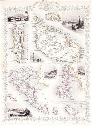
No Binding. Condición: Very Good. 1st Edition. Tallis, John: British Possessions in the Mediterranean, London. [ca.1851]. From the Montgomery Martin Illustrated Atlas. Map engraved by Rapkin. Size approx 360 x 260mm. Original steel engraved map with original outline hand colouring. 6 vignettes include Valetta, Corfu, Vathi Ithac… and Gibraltar. Decorative border. Single page unfolded map in excellent, clean condition. Associated text page of the Montgomery Martin Atlas included. A good Tallis Map. Map engraved by Rapkin. (ilustrador).
 Más imágenes
Idioma: Inglés
Editorial: From the Montgomery Martin Illustrated Atlas., london, 1850
- Primera edición
- Mapa
Librería: Roz Hulse, Plymouth, DEVON, Reino UnidoRoz Hulse
Contactar con el vendedorVendedor de 5 estrellasCondición: Usado - Bueno
EUR 96,18
Envío por EUR 40,85Se envía de Reino Unido a Estados Unidos de AmericaCantidad disponible: 1 disponibles
No Binding. Condición: Very Good. 1st Edition. Tallis, John: South Australia. London. [ca.1851]. From the Montgomery Martin Illustrated Atlas. Map engraved by Rapkin. Size approx 360 x 260mm. Original steel engraved map with original outline hand colouring and decorative border. 5 vignettes include Australian Dog, Natives on a C…atamaran and Adelaide. Single page unfolded map in excellent, clean condition. Associated text page of the Montgomery Martin Atlas included. A good Tallis Map. Map engraved by Rapkin. (ilustrador).
 Más imágenes
Editorial: THE LONDON PRINTING & PUBLISHING COMPANY CIRCA 1860, 1860
- Mapa
Librería: Elder Books, Ross on Wye, Herefordshire, Reino UnidoElder Books
Contactar con el vendedorVendedor de 5 estrellasCondición: Usado - Bueno
EUR 54,10
Envío por EUR 13,95Se envía de Reino Unido a Estados Unidos de AmericaCantidad disponible: 1 disponibles
No Binding. Condición: Very Good. AN ORIGINAL 19th CENTURY PLAN WITH SEVERAL SMALL STEEL ENGRAVED VIGNETTES & DECORATED BORDER, MEASURES APPROX 14 X 10.5 INCHES WITH MARGINS, BLANK REVERSE TO MAP. CENTRE FOLD TO MAP AS PUBLISHED, VERY LIGHT EVEN BROWNING TO MAP & MARGINS. OVERALL IN VERY GOOD CONDITION. EXTRA POSTAGE COSTS MAY A…PPLY TO OVERSEAS ORDERS. ALL ITEMS POSTED IN STURDY BOX.
 Más imágenes
Editorial: THE LONDON PRINTING & PUBLISHING COMPANY CIRCA 1850, 1850
- Mapa
Librería: Elder Books, Ross on Wye, Herefordshire, Reino UnidoElder Books
Contactar con el vendedorVendedor de 5 estrellasCondición: Usado - Bueno
EUR 54,10
Envío por EUR 13,95Se envía de Reino Unido a Estados Unidos de AmericaCantidad disponible: 1 disponibles
No Binding. Condición: Very Good. AN ORIGINAL 19th CENTURY MAP WITH EARLY HAND COLOURING, MEASURES APPROX 14 X 10.5 INCHES WITH MARGINS, BLANK REVERSE TO MAP. CENTRE FOLD TO MAP AS PUBLISHED, SOME VERY MINOR MARKS TO MARGINS. OVERALL IN VERY GOOD PLUS CONDITION. EXTRA POSTAGE COSTS MAY APPLY TO OVERSEAS ORDERS. ALL ITEMS POSTED…IN STURDY BOX.
 Más imágenes
Idioma: Inglés
Editorial: Montgomery Martin, London, 1851
- Primera edición
- Mapa
Librería: Roz Hulse, Plymouth, DEVON, Reino UnidoRoz Hulse
Contactar con el vendedorVendedor de 5 estrellasCondición: Usado - Bueno
EUR 120,22
Envío por EUR 40,85Se envía de Reino Unido a Estados Unidos de AmericaCantidad disponible: 1 disponibles
No Binding. Condición: Very Good. 1st Edition. Tallis, John: Japan and Corea [Korea], London. [ca.1851]. From the Montgomery Martin Illustrated Atlas. Map engraved by Rapkin. Size approx 360 x 260mm. Original steel engraved map with original outline hand colouring. 3 vignette views showing Coreans [Koreans], State Barge, and Yed…o. Decorative border. Single page unfolded map in excellent, clean condition. Associated text page of the Montgomery Martin Atlas included. A Good Tallis Map. Engraved by Rapkin (ilustrador).
Editorial: The London Printing and Publishing Company, 1850
- Mapa
Librería: AMBRA BOOKS (Aitchison & Cornish), Bristol, Reino UnidoAMBRA BOOKS (Aitchison & Cornish)
Contactar con el vendedorVendedor de 3 estrellasCondición: Usado
EUR 60,11
Envío por EUR 22,18Se envía de Reino Unido a Estados Unidos de AmericaCantidad disponible: 1 disponibles
Size 14" x 18", decorative border, 8 vignette views around the edge, including Railway Station, School of Design. Central fold. Streets named. --- Please e-mail for one of my FREE CATALOGUES which include WARWICKSHIRE [ Manuscripts, Maps, Ephemera, Views, etc., etc. ] -- -.

Editorial: The Illustrated Atlas and Modern History of the World Geographical, Political, Commercial & Statistical. John Tallis & Company. 1850, 1850
Librería: Peter Harrington. ABA/ ILAB., London, Reino UnidoPeter Harrington. ABA/ ILAB.
Contactar con el vendedorVendedor de 5 estrellasCondición: Usado
EUR 72,13
Envío por EUR 25,68Se envía de Reino Unido a Estados Unidos de AmericaCantidad disponible: 1 disponibles
A highly decorative map for the period with vignettes showing towns and local scenes, the whole enclosed in an elegant border Steel engraving. Good condition, central vertical fold not effecting image. Original outline colour. Size: 33 x 26 cm. (13 x 10 inches).

Editorial: The Illustrated Atlas and Modern History of the World Geographical, Political, Commercial & Statistical. John Tallis & Company. 1850, 1850
Librería: Peter Harrington. ABA/ ILAB., London, Reino UnidoPeter Harrington. ABA/ ILAB.
Contactar con el vendedorVendedor de 5 estrellasCondición: Usado
EUR 78,15
Envío por EUR 25,68Se envía de Reino Unido a Estados Unidos de AmericaCantidad disponible: 1 disponibles
A highly decorative map for the period with vignettes showing towns and local scenes, the whole enclosed in an elegant border Steel engraving. Good condition. Central vertical fold slight browning. Original outline colour with later additions. Size: 33 x 26 cm. (13 x 10 inches).

Editorial: The Illustrated Atlas and Modern History of the World Geographical, Political, Commercial & Statistical. John Tallis & Company. 1850, 1850
Librería: Peter Harrington. ABA/ ILAB., London, Reino UnidoPeter Harrington. ABA/ ILAB.
Contactar con el vendedorVendedor de 5 estrellasCondición: Usado
EUR 78,15
Envío por EUR 25,68Se envía de Reino Unido a Estados Unidos de AmericaCantidad disponible: 1 disponibles
A highly decorative map for the period with vignettes showing towns and local scenes, the whole enclosed in an elegant border Steel engraving. Good condition. Central vertical fold dreasing. Original outline colour with later additions. Size: 33 x 26 cm. (13 x 10 inches).

Editorial: The Illustrated Atlas and Modern History of the World Geographical, Political, Commercial & Statistical. John Tallis & Company. 1850, 1850
Librería: Peter Harrington. ABA/ ILAB., London, Reino UnidoPeter Harrington. ABA/ ILAB.
Contactar con el vendedorVendedor de 5 estrellasCondición: Usado
EUR 90,17
Envío por EUR 25,68Se envía de Reino Unido a Estados Unidos de AmericaCantidad disponible: 1 disponibles
A highly decorative map for the period with vignettes showing towns and local scenes, the whole enclosed in an elegant border Steel engraving. Fine condition. Original outline colour with later additions. Size: 33 x 26 cm. (13 x 10 inches).

Russia in Europe [map] From 'Tallis's Illustrated Atlas' of 1851
Rapkin, J. illustrated by A. H. Wray, engraved by T. Fleming
Editorial: Published by J. F. Tallis no date given[1850], London, 1850
- Primera edición
- Mapa
Librería: Keoghs Books, Skipton, Reino UnidoKeoghs Books
Contactar con el vendedorVendedor de 5 estrellasMiembro de asociación: PBFA
Condición: Usado
EUR 90,17
Envío por EUR 32,68Se envía de Reino Unido a Estados Unidos de AmericaCantidad disponible: 1 disponibles
, folded map coloured in outline, with engraved illustrations around outside including Polish captives on their way to Siberia, a Russian Bear, and others, from 'Tallis's Illustrated Atlas' of 1851 published in London at the time of the Great Exhibition First Edition , few small edge tears with one larger tear affecting the deco…rative border, small piece chipped at top corner and small hole to lower edge not affecting the map, clean and in fair condition 36 x 27 cm Map ISBN.

Editorial: The Illustrated Atlas and Modern History of the World Geographical, Political, Commercial & Statistical. John Tallis & Company. 1850, 1850
Librería: Peter Harrington. ABA/ ILAB., London, Reino UnidoPeter Harrington. ABA/ ILAB.
Contactar con el vendedorVendedor de 5 estrellasCondición: Usado
EUR 102,19
Envío por EUR 25,68Se envía de Reino Unido a Estados Unidos de AmericaCantidad disponible: 1 disponibles
A highly decorative map for the period with vignettes showing towns and local scenes, the whole enclosed in an elegant border Steel engraving. Good condition. Central vertical fold with slight age toning. Original outline colour with later additions. Size: 33 x 26 cm. (13 x 10 inches).

Editorial: The Illustrated Atlas and Modern History of the World Geographical, Political, Commercial & Statistical. John Tallis & Company. 1850, 1850
Librería: Peter Harrington. ABA/ ILAB., London, Reino UnidoPeter Harrington. ABA/ ILAB.
Contactar con el vendedorVendedor de 5 estrellasCondición: Usado
EUR 102,19
Envío por EUR 25,68Se envía de Reino Unido a Estados Unidos de AmericaCantidad disponible: 1 disponibles
A highly decorative map for the period with vignettes showing towns and local scenes, the whole enclosed in an elegant border Steel engraving. Good condition. Central vertical fold with slight age toning. Original outline colour. Size: 33 x 26 cm. (13 x 10 inches).

Editorial: London. John Tallis & Co. 1851, 1851
Librería: J. Patrick McGahern Books Inc. (ABAC), Ottawa, ON, CanadaJ. Patrick McGahern Books Inc. (ABAC)
Contactar con el vendedorVendedor de 4 estrellasCondición: Usado
EUR 126,80
Envío por EUR 8,74Se envía de Canada a Estados Unidos de AmericaCantidad disponible: 1 disponibles
sheet size 27x 36cm, image size 19.5x30cm, centre fold as issued, outline colour, very good to fine. (Ads).

Editorial: The Illustrated Atlas and Modern History of the World Geographical, Political, Commercial & Statistical. John Tallis & Company. 1850, 1850
Librería: Peter Harrington. ABA/ ILAB., London, Reino UnidoPeter Harrington. ABA/ ILAB.
Contactar con el vendedorVendedor de 5 estrellasCondición: Usado
EUR 114,21
Envío por EUR 25,68Se envía de Reino Unido a Estados Unidos de AmericaCantidad disponible: 1 disponibles
A highly decorative map for the period with vignettes showing towns and local scenes, the whole enclosed in an elegant border. Steel engraving. In very good condition. Vertical central fold, as issued. Original outline colour with later additions.26802 Size: 33 x 26 cm. (13 x 10 inches).

Editorial: The Illustrated Atlas and Modern History of the World Geographical, Political, Commercial & Statistical. John Tallis & Company. 1850, 1850
Librería: Peter Harrington. ABA/ ILAB., London, Reino UnidoPeter Harrington. ABA/ ILAB.
Contactar con el vendedorVendedor de 5 estrellasCondición: Usado
EUR 114,21
Envío por EUR 25,68Se envía de Reino Unido a Estados Unidos de AmericaCantidad disponible: 1 disponibles
A highly decorative map for the period with vignettes showing towns and local scenes, the whole enclosed in an elegant border. Steel engraving. In fine condition. Original outline colour with later additions. Size: 33 x 26 cm. (13 x 10 inches).

Editorial: TALLIS 1850, 1850
Librería: PROCTOR / THE ANTIQUE MAP & BOOKSHOP, DORCHESTER, Reino UnidoPROCTOR / THE ANTIQUE MAP & BOOKSHOP
Contactar con el vendedorVendedor de 5 estrellasMiembro de asociación: PBFA
Condición: Usado
EUR 132,25
Envío por EUR 23,34Se envía de Reino Unido a Estados Unidos de AmericaCantidad disponible: 1 disponibles
Size 10.5 x 14 inches. Hand Coloured Engraving. In good condition. Some light tanning, small tear & crease lower edge, tiny loss top left margin corner. Two small tape repairs on verso of centre fold. An attractive and decorative mapwith stunning vignette engravings in the borders. Drawn engraved by John Rapkin for The Illustrat…ed Atlas and Modern History of the World by Martin Montgomery.


