
Atlas maps (30 resultados)

- Tapa blanda
Librería: medimops, Berlin, Alemaniamedimops
Contactar con el vendedorVendedor de 5 estrellasCondición: Usado - Aceptable
EUR 3,84
Envío por EUR 10,00Se envía de Alemania a Estados Unidos de AmericaCantidad disponible: 1 disponibles
Condición: good. Befriedigend/Good: Durchschnittlich erhaltenes Buch bzw. Schutzumschlag mit Gebrauchsspuren, aber vollständigen Seiten. / Describes the average WORN book or dust jacket that has all the pages present.

Idioma: Inglés
Editorial: Ernest Benn Limited, London and Tonbridge, England, 1981
- Tapa blanda
Librería: Ryde Bookshop Ltd, Isle of Wight, Reino UnidoRyde Bookshop Ltd
Contactar con el vendedorVendedor de 5 estrellasCondición: Usado - Aceptable
EUR 3,03
Envío por EUR 23,41Se envía de Reino Unido a Estados Unidos de AmericaCantidad disponible: 1 disponibles
Soft cover. Condición: Good. First Thus. Atlas, maps and plans by John Fowler (ilustrador).

Idioma: Inglés
Editorial: Ernest Benn Ltd, Chicago, New York, San Francisco, 1975
- Tapa blanda
Librería: Ryde Bookshop Ltd, Isle of Wight, Reino UnidoRyde Bookshop Ltd
Contactar con el vendedorVendedor de 5 estrellasCondición: Usado - Aceptable
EUR 3,62
Envío por EUR 23,41Se envía de Reino Unido a Estados Unidos de AmericaCantidad disponible: 1 disponibles
Soft cover. Condición: Good. First thus, second impression. Few marks and general light handling wear on cover and spine. street atlas and 26 maps (ilustrador).

Idioma: Inglés
Editorial: J.M. Dent & Sons Ltd., London, 1965
- Tapa dura
Librería: Ryde Bookshop Ltd, Isle of Wight, Reino UnidoRyde Bookshop Ltd
Contactar con el vendedorVendedor de 5 estrellasCondición: Usado - Bueno
EUR 4,83
Envío por EUR 23,41Se envía de Reino Unido a Estados Unidos de AmericaCantidad disponible: 1 disponibles
Hardcover. Condición: Very Good. Estado de la sobrecubierta: Fair. Revised Edition. Jacket is price clipped, there are tears, scuffing, creases and dust spotting on it. with an Atlas of 32 coloured maps edited by JOhn Bartholomew (ilustrador).
A field guide to the stars and planets
Menzel, Donald Howard and Jay M. Pasachoff ; with monthly sky maps and atlas charts by Wil Tirion
Editorial: 0395348358
Librería: Inkberry Books, Niwot, CO, Estados Unidos de AmericaInkberry Books
Contactar con el vendedorVendedor de 3 estrellasCondición: Usado
EUR 10,82
Envío por EUR 3,49Se envía dentro de Estados Unidos de AmericaCantidad disponible: 1 disponibles
Very Good. Astronomy Observers' manuals.

- Tapa blanda
Librería: PBShop.store US, Wood Dale, IL, Estados Unidos de AmericaPBShop.store US
Contactar con el vendedorVendedor de 5 estrellasCondición: Nuevo
EUR 32,08
Gastos de envío gratisSe envía dentro de Estados Unidos de AmericaCantidad disponible: 15 disponibles
PAP. Condición: New. New Book. Shipped from UK. Established seller since 2000.
- Tapa blanda
Librería: PBShop.store US, Wood Dale, IL, Estados Unidos de AmericaPBShop.store US
Contactar con el vendedorVendedor de 5 estrellasCondición: Nuevo
EUR 32,11
Gastos de envío gratisSe envía dentro de Estados Unidos de AmericaCantidad disponible: 15 disponibles
PAP. Condición: New. New Book. Shipped from UK. Established seller since 2000.
- Tapa blanda
Librería: PBShop.store UK, Fairford, GLOS, Reino UnidoPBShop.store UK
Contactar con el vendedorVendedor de 5 estrellasCondición: Nuevo
EUR 29,30
Envío por EUR 5,89Se envía de Reino Unido a Estados Unidos de AmericaCantidad disponible: 15 disponibles
PAP. Condición: New. New Book. Shipped from UK. Established seller since 2000.
- Tapa blanda
Librería: PBShop.store UK, Fairford, GLOS, Reino UnidoPBShop.store UK
Contactar con el vendedorVendedor de 5 estrellasCondición: Nuevo
EUR 29,42
Envío por EUR 5,89Se envía de Reino Unido a Estados Unidos de AmericaCantidad disponible: 15 disponibles
PAP. Condición: New. New Book. Shipped from UK. Established seller since 2000.
 Más imágenes
Idioma: Inglés
Editorial: C. S. Hammond & Company, Inc, New York., 1931
- Tapa dura
Librería: Librería "Franz Kafka" México., Cuernavaca, MOR, MéxicoLibrería "Franz Kafka" México.
Contactar con el vendedorVendedor de 5 estrellasCondición: Usado - Regular
EUR 28,09
Envío por EUR 9,41Se envía de México a Estados Unidos de AmericaCantidad disponible: 1 disponibles
Encuadernación de tapa dura. Condición: Regular. Características: Pasta dura en tela editorial. Estado regular. Las tapas están ligeramente raspadas de las orillas y de las esquinas. El lomo está levemente raspado de los costados y presenta fatiga en ambos extremos. Letras y recuadro dorado estampados en la portada y grecas esta…mpadas en relieve. El lomo lleva letras doradas, pero están un poco despintadas. Cantos limpios. Guardas limpias. Antes de los mapas hay un índice de países y otro de ciudades y pueblos. Los mapas son excelentes y están impresos en colores. El texto está dividido en las siguientes partes: Foreign Maps, Index of Dominion of Canada, Part III Physical and Economic Maps y Part IV Descriptive Gazetteer of the World Illustrated. Esta última parte incluye una breve descripción de la ciudad y unas fotografías. 278 pp. (25 x 17 cm). Peso: 950 g.

- Tapa dura
Librería: PBShop.store US, Wood Dale, IL, Estados Unidos de AmericaPBShop.store US
Contactar con el vendedorVendedor de 5 estrellasCondición: Nuevo
EUR 41,40
Gastos de envío gratisSe envía dentro de Estados Unidos de AmericaCantidad disponible: 15 disponibles
HRD. Condición: New. New Book. Shipped from UK. Established seller since 2000.
Editorial: J.M. Dent & Sons Ltd., London, 1963
- Tapa dura
Librería: Ryde Bookshop Ltd, Isle of Wight, Reino UnidoRyde Bookshop Ltd
Contactar con el vendedorVendedor de 5 estrellasCondición: Usado - Aceptable
EUR 4,83
Envío por EUR 23,41Se envía de Reino Unido a Estados Unidos de AmericaCantidad disponible: 1 disponibles
Hardcover. Condición: Good. Revised Edition. Firmly bound, yellow cloth boards. Dust spotting marks on cover and spine. No jacket. with an Atlas of 24 coloured maps, edited by John Bartholomew (ilustrador).
- Tapa dura
Librería: PBShop.store UK, Fairford, GLOS, Reino UnidoPBShop.store UK
Contactar con el vendedorVendedor de 5 estrellasCondición: Nuevo
EUR 37,87
Envío por EUR 5,89Se envía de Reino Unido a Estados Unidos de AmericaCantidad disponible: 15 disponibles
HRD. Condición: New. New Book. Shipped from UK. Established seller since 2000.
Editorial: Easton Press, Norwalk, Cn., 1984
- Tapa dura
Librería: Lawrence Jones Books, Ashmore, QLD, AustraliaLawrence Jones Books
Contactar con el vendedorVendedor de 5 estrellasCondición: Usado - Bueno
EUR 15,64
Envío por EUR 21,89Se envía de Australia a Estados Unidos de AmericaCantidad disponible: 1 disponibles
Hard Cover. Condición: Very Good. Collectors Lifetime Edition. x, 473pp, color and bw plates, line drawings, appendix tables, glossary, bibliography, index, endpapers: general sky map and index to the atlas charts (front: northern; rear: southern hemisphere). Original brown leather with gilt titles and decoration to front, all e…dges gilt, silk bookmark ribbon. Easton Press bookplate with Peterson artwork on front pastedown (with name filled in). Some spotting of edge gilt. Presented to the usual high standards of the Easton Press, this attractive volume presents tours of the stars, the planets, the sun, the moon, and other objects in the heavens. Size: 8vo. Monthly Sky Maps and Atlas Charts By Wil Tirion (ilustrador).
Editorial: Townsend MacCoun,, New York:, 1888
- Tapa dura
Librería: Zephyr Used & Rare Books, Vancouver, WA, Estados Unidos de AmericaZephyr Used & Rare Books
Contactar con el vendedorVendedor de 5 estrellasCondición: Usado
EUR 31,56
Envío por EUR 7,00Se envía dentro de Estados Unidos de AmericaCantidad disponible: 1 disponibles
Sml. folio. xvi, 213 (mispaginated). 71 colour maps, numerous genealogical tables. Olive green cloth, blk lettrng & rulng (mnr bmpng, rubbng & fryng hd & ft of spine, mnr bmpng to crnrs), still nice copy from library of Theodore Barton Akeley II. Revised edition of Labbertons famed atlas, which for this edition had entirely new…plates, as the previous plates were destroyed in a fire prior to this publication.

Geological Survey of Canada, Report of Progress From Its Commencement to 1863: Illustrated by 498 Wood Cuts in the Text, and Accompanied by an Atlas of Maps and Sections (Classic Reprint)
Illustrated By 498 Wood Cuts In The Text, And Accompanied By An Atlas Of Maps And Sections
- Tapa blanda
Librería: Majestic Books, Hounslow, Reino UnidoMajestic Books
Contactar con el vendedorVendedor de 4 estrellasCondición: Nuevo
EUR 51,15
Envío por EUR 7,62Se envía de Reino Unido a Estados Unidos de AmericaCantidad disponible: 1 disponibles
Condición: New.
Geological Survey of Canada, Report of Progress From Its Commencement to 1863: Illustrated by 498 Wood Cuts in the Text, and Accompanied by an Atlas of Maps and Sections (Classic Reprint)
Illustrated By 498 Wood Cuts In The Text, And Accompanied By An Atlas Of Maps And Sections
- Tapa blanda
Librería: Books Puddle, New York, NY, Estados Unidos de AmericaBooks Puddle
Contactar con el vendedorVendedor de 4 estrellasCondición: Nuevo
EUR 57,59
Envío por EUR 3,49Se envía dentro de Estados Unidos de AmericaCantidad disponible: 1 disponibles
Condición: New.
Editorial: J. M. Dent & Sons, New York
- Tapa dura
Librería: CHARLES BOSSOM, Ely, CAMBS, Reino UnidoCHARLES BOSSOM
Contactar con el vendedorVendedor de 5 estrellasCondición: Usado - Bueno
EUR 4,83
Envío por EUR 35,18Se envía de Reino Unido a Estados Unidos de AmericaCantidad disponible: 1 disponibles
Hard Cover. Condición: Very Good. Estado de la sobrecubierta: Good. Dust jacket unclipped. Rubbing and small closed tears to spine ends. Faded orange cloth with black lettering to spine. No inscriptions. 275 pages, light foxing to page edges, otherwise clean and tightly bound. Size: 4.5" By 7" Tall. An Atlas of 32 Coloured Maps…(ilustrador).
 Más imágenes
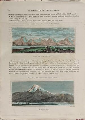
Earth: Mountains
Probably from A General Atlas, Containing Maps illustrating some important periods in Ancient History; and distinct Maps of the several Empires, Kingdoms and States In The World by J. Wyld, 1824.
- Arte / Grabado / Póster
Librería: theoldmapman, Clevedon, SOMER, Reino Unidotheoldmapman
Contactar con el vendedorVendedor de 5 estrellasCondición: Usado
EUR 16,91
Envío por EUR 7,62Se envía de Reino Unido a Estados Unidos de AmericaCantidad disponible: 1 disponibles
Single print. Original antique double sided folio sheet with three engraved and hand coloured views of The Grampians, Mont Blanc and Chimberazo in Mexico. Engraved by W. H. Lizars. 26.5 x 36.5 cm.
 Más imágenes
Topography of Great Britain, or British Traveller's Pocket Directory
With the Adjacent Islands; Illustrated With Maps of the Countries Which Form a Complete British Atlas, G. A. Cooke
- Tapa blanda
- Impresión bajo demanda
Librería: Forgotten Books, London, Reino UnidoForgotten Books
Contactar con el vendedorVendedor de 4 estrellasCondición: Nuevo
EUR 20,47
Gastos de envío gratisSe envía de Reino Unido a Estados Unidos de AmericaCantidad disponible: Más de 20 disponibles
Paperback. Condición: New. Print on Demand. This book provides an in-depth exploration of Worcestershire during the 18th century. The author meticulously compiles information relevant to the county during this time period, including details on mines, fisheries, manufactures, trade, commerce, civil and ecclesiastical jurisdiction…, and much more. Particular attention is given to the detailed listing of markets and fairs, as well as a comprehensive index table exhibiting distances between all the towns and villages. This thorough compendium offers a valuable resource for historians and anyone with an interest in 18th-century Worcestershire. This book is a reproduction of an important historical work, digitally reconstructed using state-of-the-art technology to preserve the original format. In rare cases, an imperfection in the original, such as a blemish or missing page, may be replicated in the book. print-on-demand item.

Historical Atlas of Canada: Canada's History Illustrated With Original Maps Derek Hayes
Historical Atlas of Canada: Canada's History Illustrated With Original Maps Derek Hayes
- Tapa dura
Librería: Aragon Books Canada, OTTAWA, ON, CanadaAragon Books Canada
Contactar con el vendedorVendedor de 3 estrellasCondición: Nuevo
EUR 99,20
Envío por EUR 20,14Se envía de Canada a Estados Unidos de AmericaCantidad disponible: 1 disponibles
Condición: New.
Historical Atlas of Canada: Canada's History Illustrated With Original Maps Derek Hayes
Historical Atlas of Canada: Canada's History Illustrated With Original Maps Derek Hayes
- Tapa dura
Librería: Aragon Books Canada, OTTAWA, ON, CanadaAragon Books Canada
Contactar con el vendedorVendedor de 3 estrellasCondición: Nuevo
EUR 129,86
Envío por EUR 20,14Se envía de Canada a Estados Unidos de AmericaCantidad disponible: 1 disponibles
Condición: New.

Idioma: Inglés
Editorial: Thomas & Andrews, Boston Ma, 1810
- Tapa dura
Librería: Arroyo Seco Books, Pasadena, Member IOBA, Pasadena, CA, Estados Unidos de AmericaArroyo Seco Books, Pasadena, Member IOBA
Contactar con el vendedorVendedor de 4 estrellasMiembro de asociación: IOBA
Condición: Usado - Aceptable
EUR 161,01
Envío por EUR 7,00Se envía dentro de Estados Unidos de AmericaCantidad disponible: 1 disponibles
Hardcover. Condición: Good. 3rd Edition. Third And Best Edition. Full Sheep With Red Morocco Spine Label Lettered In Git. Unpaginated, Two Column Format. Massive Alphabetical Geography Of The Western Hemisphere. Quite Worn But Intact, Morocco Spine Label Complete With Bright Gilt. Folding Maps Of North America (With Caribbean) A…nd South America, Worn And With Tears Along Creases But Intact. Lacking The Rare Atlas Volume. Front Free Endpaper With Attached Slip Of Paper With Ownership Signatures Of Jabez Harding (1813-1897), Sturbridge Ms, Jan 25, 1836, Reverse With Signature Of Cynthia A. Harding, Sturbridge Mass. Illustrated With 2 Folding Maps But Lacking The Separate Atlas Volume (ilustrador).
- Tapa blanda
Librería: BWS BKS, Ferndale, NY, Estados Unidos de AmericaBWS BKS
Contactar con el vendedorVendedor de 1 estrellasCondición: Usado - Como Nuevo
EUR 1781,96
Envío por EUR 2,63Se envía dentro de Estados Unidos de AmericaCantidad disponible: 2 disponibles
Paperback. Condición: As New.

USSR Geographical Atlas for Secondary School Teachers
(USSR - Soviet Union - Communist Era - Geography - Atlas of Maps)
Editorial: MVD (Ministry of Internal Affairs USSR), Moscow, U.S.S.R., 1959
- Tapa dura
- Primera edición
Librería: Certain Books, ABAA, Las Cruces, NM, Estados Unidos de AmericaCertain Books, ABAA
Contactar con el vendedorVendedor de 3 estrellasCondición: Usado - Bueno
EUR 225,45
Envío por EUR 9,63Se envía dentro de Estados Unidos de AmericaCantidad disponible: 1 disponibles
Hard Cover. Condición: Very Good. First Edition. viii + 191 pages; useful index. Very well-printed lithographed color maps and charts. With geographic maps, maps and charts of the solar system, physical features, climate, world and country-by-country maps; more than half of the atlas concerns the then-U.S.S.R; text entirely in C…yrillic. Laid-in is an article from the NY Times Jan. 28, 1973: 'Chinese Names for Towns in Siberia are Eliminated.' The volume approx. 10 3/4" x 15" size; bound in red cloth, gilt cover and spine titles (dulled); some edge, tips wear and rubbing to the boards; contents clean, maps' coloring bright and in very good condition.
 Más imágenes
Editorial: [Hendrik de Leth], Amsterdam, 1766
- Tapa dura
- Primera edición
Librería: The First Edition Rare Books, LLC, Cincinnati, OH, Estados Unidos de AmericaThe First Edition Rare Books, LLC
Contactar con el vendedorVendedor de 5 estrellasCondición: Usado - Bueno
EUR 2254,51
Envío por EUR 5,25Se envía dentro de Estados Unidos de AmericaCantidad disponible: 1 disponibles
Leather bound. Condición: Very good. First Edition. Twelvemo, [title], [65pp], [maps]. Period calf, title in faint gilt along spine, decorative raised bands. Previous booksellers description affixed to front pastedown. Marginalia in pencil on rear endpaper, ownership inscription in ink on front pastedown. Both hinges reinforced…with archival tissue. This work includes 53 of 54 plates, many fold-out and hand-colored maps of The Netherlands, Amsterdam, distance tables, a plate of flags and regional maps of Northwestern Europe. Maps individually numbered by hand, out of sequence with "Plate Register." This work is lacking Plate 19: "Platte grond van's Gravenhage." Occasional toning to plates, a few with notable wear at hinges, a very good example of this scarce work. Hendrik de Leth (1703-1766) was a Dutch engraver, cartographer, and publisher known for his detailed maps and topographical works during the 18th century. He produced cityscapes, landscapes, and illustrations that captured the geography and architecture of the Netherlands and other regions. De Leth collaborated with prominent mapmakers and published atlases that gained recognition for their accuracy and artistic quality. His works, such as maps of Amsterdam and other Dutch cities, are valuable historical records, providing insights into urban development and geographic knowledge of his time. The first edition of Nieuwe Geographische en Historische Atlas, published in 1766 by Hendrik de Leth, with hand-colored maps of The Netherlands. (ilustrador).
Editorial: Aux dépens de la Compagnie, Amsterdam, 1718
- Tapa dura
Librería: Sanctuary Books, A.B.A.A., New York, NY, Estados Unidos de AmericaSanctuary Books, A.B.A.A.
Contactar con el vendedorVendedor de 5 estrellasCondición: Usado - Aceptable
EUR 1082,16
Envío por EUR 4,38Se envía dentro de Estados Unidos de AmericaCantidad disponible: 1 disponibles
Hardcover. Condición: Good. Contemporary speckled calf, handsomely rebacked but one board detached; gilt-stamped lettering in tan leather spine label (second compartment), gilt-stamped ornament on 5 raised bands and direct in spine compartments; 3 volumes, 12mo (163x95mm); pp. [10], 336, [35]; [16], 333, [51]; [14], 468, [32]; w…ith hand-colored engraved half-title in Volume I, 18 hand-colored plates (many folding), hand-colored decorative head- and tail-pieces. Front rear board on volume one detached. Boards a bit scuffed along the edges; corners bumped; spines dry. Internally bright and clean; previous owner's (tasteful) bookplate. Plates are lovely.
Editorial: Roe Brothers (1879), St. John & Portland, N.B., 1879
Librería: Schooner Books Ltd.(ABAC/ALAC), Halifax, NS, CanadaSchooner Books Ltd.(ABAC/ALAC)
Contactar con el vendedorVendedor de 4 estrellasCondición: Usado
EUR 248,00
Envío por EUR 21,89Se envía de Canada a Estados Unidos de AmericaCantidad disponible: 1 disponibles
Eleven separate single sheets Pp. From "Atlas of the Maritime Provinces of the Dominion of Canada. With Historical and Geological Descriptions." Published 1879 by the Roe Brothers, St. John & Portland, N.B. Maps include County of Gloucester [Plate #35], Counties of Restigouche and Madawaska [Plate #24 & 25]; County of Northumber…land [Plate #38 & 39];County of Kent[Plate #41];County of Saint John[Plate #47]; Counties of Sunbury and Queens[Plate #43];County of York[Plate #31];County of Kings[Plate #45];County of Victoria[Plate #27]; County of Carleton [Plate #29]; County of Charlotte [Plate #33] All maps have minor damp staining and tears to edges but generally very good. All are single sheet with some topographic detail except for Northumberland & Restigouche and Madawaska which are double sheets Each single sheet with some topographic detail.
Editorial: N, N, 1985
Librería: Kay Craddock - Antiquarian Bookseller, Melbourne, VIC, AustraliaKay Craddock - Antiquarian Bookseller
Contactar con el vendedorVendedor de 5 estrellasCondición: Usado
EUR 1563,74
Envío por EUR 22,76Se envía de Australia a Estados Unidos de AmericaCantidad disponible: 1 disponibles
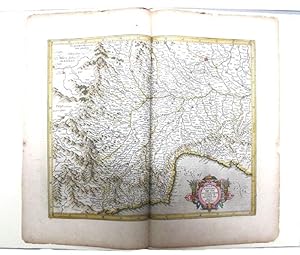
Pp. [viii]+24+[2](colophon, blank), pictorial title page printed in red & black, 5 decorative initials printed in red, black & white pictorial or decorative tailpieces, pictorial endpapers, notes, bibliography; med. folio; qr. vein-patterned vellum, spine lettered in gilt, grey papered boards, decorated in gilt; fore and bottom…edges uncut; within black cloth slipcase, which is a trifle marked; Stone & Lorson, Fullerton, California, 1985. Edition limited to 115 copies; this one of 89 thus bound. Hamel 186. *The hand coloured double page map tipped-in at the centre shows Pede Montana regio cum Genvensium territorio (part of modern Italy). The French text on the reverse includes a large decorative initial, and is lightly foxed. The leaf is from the 1619 French edition of Mercator's World Atlas, which was the fourteenth edition of the celebrated cartographer's magnus opus. Parts of the atlas had been printed during Mercator's lifetime, but the entire work was not published until a couple of years after his death in 1594.

- Mapa
Librería: Geographicus Rare Antique Maps, Brooklyn, NY, Estados Unidos de AmericaGeographicus Rare Antique Maps
Contactar con el vendedorVendedor de 4 estrellasCondición: Usado
EUR 2525,05
Envío por EUR 14,88Se envía dentro de Estados Unidos de AmericaCantidad disponible: 1 disponibles
Very good. Size 13 x 15.25 Inches. This is a fascinating and historically significant portion of the 1866 Qing Era Guangdong Atlas (???) showing the Pearl River Delta, including Hong Kong and Macao. The atlas was extraordinarily detailed for its time, meticulously naming small villages and minor, uninhabited maritime features. A…tlas Overview These maps compose the 11th volume (???) of the atlas, showing both sides of the southernmost portion of the Pearl River Delta, including Hong Kong and what is now Shenzhen to the east, and Macao along with portions of the present-day municipalities of Zhongshan, Zhuhai, and Jiangmen to the west. The maps utilize a grid system, common in the Chinese cartographic tradition, that corresponds to a map of the entire province on a larger scale (??) that constitutes the first volume of the atlas. Compared to a map of Guangdong today, some place names are entirely unchanged, while others have been modified somewhat (for example, ??? to ???), possibly due to differences between Cantonese and Mandarin, and in other cases are completely different, due to both historical and geographic reasons, such as landfill and changes in the coastline. Throughout, symbols are used along coastal waters, the meaning of which are not always clear. The small dots appear to represent shoals and reefs that are dangerous for ships, while the larger dots in a line may indicate the safest route for ships to transit the waters. Hong Kong and Environs Following the composite image, the second image above illustrates the area around Hong Kong, including much of what is now Shenzhen, the boom town and special economic zone that has become one of China's largest cities in the past forty years. The pages are titled for Xin'an (??), which is now a residential area in Bao'an District, Shenzhen. Hong Kong Island (??) is just to the right of the dividing line between the two pages, while Kowloon (with its government office ??? and fortifications ????, the latter coming to be known as the 'Kowloon Walled City,' ????) and its tip opposite Hong Kong Island at Tsim Sha Tsui (???) are visible to its north. At left is the eastern portion of Lantau Island and surrounding islands, including Lamma Island (here as ??). No mention is made of the British presence on Hong Kong Island (since 1842) or Kowloon (since 1860), though in the latter case this is less remarkable, as Kowloon was mainly a buffer zone and not a site of significant settlement circa 1866 that was used by the British mainly for hunting. However, it was home to the just-mentioned government yamen (??) and fortifications, which had in fact long long predated the British, back to the Song Dynasty. The nearby presence of the British gave Kowloon renewed importance for the Qing as they tried to observe and control interactions with the Crown Colony. After the borders of Hong Kong were extended in 1898 with a 99-year lease, the Qing fortification was retained as an enclave of Chinese sovereign territory within the British leased territory. The fortified area remained a sticking point between Britain and China for the next century, until the eve of Hong Kong's handover (return) to Chinese sovereignty. As the British were unsure of what to do with it but reluctant to grant the Chinese government full control over the enclave, the area became home to many squatters and refugees from conflicts in the mainland, as well as a hotbed of organized crime and drugs. The Japanese destroyed the wall during World War II to build the nearby Kai Tak Airport, but the layout and name of the area remained. After the war, the population of the area skyrocketed as refugees fled the Chinese Civil War on the mainland, likely making it the most densely populated neighborhood in an already very densely populated city. Ramshackle apartment buildings were set up with no safety standards, leading to many fires and risk of buildings collapsing. Structures were lined up with no space between them and residents.


