Descripción
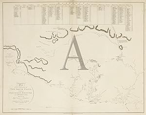
A RARITY - FIRST EDITION OF ARROWSMITHS CHART OF NEW SOUTH WALES 1799 The first separately issued map of New South Wales by the great English cartographer Aaron Arrowsmith. First edition of this very rare and important chart, showing the progress of exploration in New South Wales since 1788. The chart shows Broken Bay, Port Jackson, Botany Bay and Port Hacking with soundings and the courses of the Hawkesbury, Parramatta and Georges rivers. The explored parts of the west, including the courses of the Grose and Nepean, are mapped. The landholdings adjoining the Parramatta River, westward to Prospect Hill, the Hawkesbury River and South Creek near Windsor are indicated. A table across the top of the map lists the names of the landholders in eleven of the fifteen districts. The road from Sydney to Parramatta, Toongabbee and the Hawkesbury Settlement (Windsor area) is drawn, as is the road from Sydney to Botany Bay. The routes taken by the exploring parties that travelled south-westwards to the Cow Pastures and Mt Hunter and the westward direction taken by Bass's party from Mt Hunter into the Blue Mountains, are shown. The outward and homeward tracks, taken by Bass and Flinders in the Tom Thumb to 'Canoe River' (the outlet of Lake Illawarra) in 1796, are also shown. On 7 September 1795 Governor Hunter arrived in New South Wales on the Reliance to take command of the settlement. On board were Matthew Flinders (masters mate) and George Bass (ships surgeon), who had formed a close friendship that was to result in the most important series of exploratory voyages in Australian history. Five weeks after landing, they set out from Port Jackson on their little eight foot boat the Tom Thumb to explore and chart the coast. On 26 October, Flinders, Bass and his young servant William Martin, sailed to Botany Bay and explored the St. George's River, 20 miles further than it had been explored before. Hunter founded Bankstown from this new information. At the end of March 1796, the three set out again in a new and larger Tom Thumb, exploring the Illawarra coast and Port Hacking, naming: Tom Thumbs Lagoon, Hat Hill (Mount Kembla), Martin's Island (Five Islands) and Providential Cove (Wattamolla). Bass made a number of land excursions and on one trip to the Cow Pastures found the escaped cattle that had been brought out in the First Fleet. He also discovered good land near Prospect Hill and attempted to cross the Blue Mountains, tackling the precipices with scaling irons and ropes, until after fourteen days the party was driven back by thirst, hunger and fatigue. After the report of coal being found on the coast, south of Sydney by survivors of the wrecked Sydney Cove, Bass promptly offered to investigate with two of the survivors. He left Port Jackson on 5 August 1797 in Governor Hunter's whale-boat, returning in eight days with specimens of the coal and a report of its abundance around Coalcliff. Issues are recorded on watermarked paper dated 1800 and 1804. A later issue published in 1815 lacks the table of landholders, depiction of individual farms and adds Evans's tracks across the Blue Mountains. On watermarked paper dated 1794, at top left of sheet. References: Edwards p.60 item 871, Ferguson 329, Prescott p.223 entry 1799.A01, Tooley 65 p.11, Wantrup pp.132-138, 66 Image Size: 710mm x 547mm (28" x 21.5"). Condition: In good condition with centre fold as issued. Technique: Copper engraving. N° de ref. del artículo RLAR 071 NSW 1799 ARRO
Contactar al vendedor
Denunciar este artículo
![]()
