Descripci�n
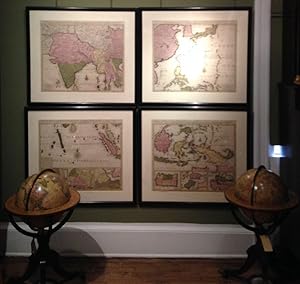
4 double-page engraved maps, each matted and framed (ca 21 x 24 inches; framed size: 28 x 52 inches). Four fine engraved maps making one large and comprehensive map of Asia in four parts, with fine original hand-colour in full: La Nouvelle grande carte des Indes Orientales Contenant Les Terres du Mongol Surate, Malabar, Cormandel, Bengale, Aragan, Pegu, Siam, Camboje, Tonquin, & une Partie de La Chine dress�e avec soin sur plusieurs cartes manuscriptes, par un habiles connoisseur, & publi�e, showing the Bay of Bengal and extending from the Pakistani border across India to the Indo-Chinese peninsula with Burma, Cambodia, Vietnam and Laos, some of China and the northern half of Sri Lanka, decorated with a large compass rose. La Nouvelle grande carte des Indes Orientales Contenant Les Empires de la Chine & du Japon, Les Isles Philippines, Couchin, & Les Isles Marianes dress�e avec soin sur plusieurs cartes manuscriptes, par un habiles connoisseur, & publi�e, showing the coast of China, Korea, the Sea of Korea, the island of Quelpaert, Japan, the Phillipines, Borneo, and the Marianas. La Nouvelle grande carte des Indes Orientales Contenant Contenant les Isles Maldives, Ceylan, Malacca, Sumatra &c. avec Les Terres adjacentes de Couchin, Negombo, Colombo & Sourabaia dress�e avec soin sur plusieurs cartes manuscriptes, par un habiles connoisseur, & publi�e, showing the Maldives, Sri Lanka, Sumatra and the Malaysian Peninsula, with three inset maps along the bottom edge [1] Carte de Royaume de Couchin de Coilan - [2] Carte de Nigombo, Colombo - [3] Carte de Princepaute de Soerabaye et Terre de Grissik, respectively showing the Malabar coastline, a part of the Sri Lankan coast including Negombo, and the Maduran Strait between Java and Madura, decorated with a large compass rose. La Nouvelle grande carte des Indes Orientales contenant les Isles de Borneo, Iava, Celebes, Mindanao, Gilolo, Molucques, La Nouvelles Philippines, avec Les Isles de Sumbawa, Serbira, Solor, Bouton & Pangesane . dress�e avec soin sur plusieurs cartes manuscriptes, par un habiles connoisseur, & publi�e, showing the island of Borneo, Celebes, Java, New Guinea, Mindanao and the Philippines, with three inset maps along the bottom edge [1] Isle de Sumbawa - [2] Isles de Serbira et de Solor - [3] Isles de Bouton et Pangesane, respectively showing the island of Sumbawa, the islands of Solor and Sebira, and the islands of Bouton and Pangesane. A magnificent map of Asia at a time of transition from Dutch dominance in the region. In 1700, at about the time that the cartography in this map dates the supremacy of the Dutch East India Company, or the VOC began to wain. Other companies, like the French East India Company and the Danish East India Company also started to make inroads in the area, based on a better knowledge of the cartography on their part, and a weakening in the importance of the traditional commodities essential to the success of the VOC trading operation. The crucial moment came with the Battle of Colachel in 1741 when the Dutch commander Captain Eustachius De Lannoy was captured by the Indian army, the first time an organized Asian power had overcome European military technology and tactics, signalling the decline of Dutch power in India. The brothers Reiner and Josua Ottens assembled collections of maps in atlas form from the 1720s until about 1750, many were taken from the stocks of the leading publishers of the day in Amsterdam or Paris, no doubt as a result of the influence which they were able to exert on their fellow members in the Amsterdam Compagnie van Boekverkopers or Booksellers Guild, of which both Reiner and Josua were at some time Governors. N� de ref. del art�culo 72map291
Contactar al vendedor
Denunciar este art�culo
