


NARRATIVE OF AN EXPEDITION TO THE SOURCE OF ST. PETER'S RIVER, LAKE WINNEPEEK, LAKE OF THE WOODS, &c. &c. PERFORMED IN THE YEAR 1823.COMPILED FROM THE NOTES OF MAJOR LONG, MESSRS. SAY, KEATING, AND COLHOUN [sic]
Keating, William H.
Editorial: Carey & Lea, Philadelphia, 1824
Usado
Librería:
William Reese Company - Americana, New Haven, CT, Estados Unidos de America
Calificación del vendedor: 3 de 5 estrellas
![]()
Vendedor de AbeBooks desde 13 de julio de 2006
Este ejemplar en concreto ya no está disponible. Estas algunas de las coincidencias similares para NARRATIVE OF AN EXPEDITION TO THE SOURCE OF ST. PETER'S RIVER, LAKE WINNEPEEK, LAKE OF THE WOODS, &c. &c. PERFORMED IN THE YEAR 1823.COMPILED FROM THE NOTES OF MAJOR LONG, MESSRS. SAY, KEATING, AND COLHOUN [sic] de Keating, William H..
Descripción
Descripción:
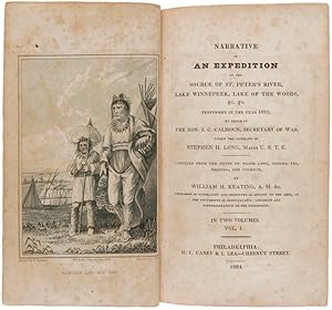
Two volumes. xii,[1],[9]-439pp. plus four plates, frontispiece, and folding map; vi,[5]- 459pp. plus frontispiece and nine plates. Half calf and marbled boards. Scattered foxing in both volumes. Map with a few delicate repairs on verso along folds. A good copy. First edition of the primary work on Stephen Long's second expedition, compiled by its geologist and historiographer. ".Almost a cyclopedia of material, relating to the Indians of the explored territory. Nothing escaped the attention of the gentlemen who accompanied the expedition; and their statements regarding the customs, character, and numbers of the Sioux and Chippeway tribes, are among the most valuable we have of those people" - Field. Includes vocabularies of several tribes. The excellent plates, engraved by Hill after the drawings of Samuel Seymour, illustrate scenes and Indians on the upper Mississippi. The map depicts the Great Lakes, the headwaters of the Mississippi, and the Red River of the North, with the river origins and the complicated hydrography of Wisconsin, Minnesota, and the border area rendered in far greater detail than ever before. Botanical collections relating to this expedition were made by the distinguished naturalist, Thomas Say. It was proposed that Thomas Nuttall write the descriptions, but in his absence the task became the responsibility of Lewis David van Schweinitz, and his work appears as an appendix in the second volume. WAGNER-CAMP 26b:1. FIELD 949. HOWES K20. PILLING, PROOF-SHEETS 2066, 3494. GRAFF 2280. SABIN 37137. AMERICAN IMPRINTS 16763. STREETER SALE 1785. TAXONOMIC LITERATURE 3560. REESE, BEST OF THE WEST 50. N° de ref. del artículo WRCAM3622
Detalles bibliográficos
Título: NARRATIVE OF AN EXPEDITION TO THE SOURCE OF ...
Editorial: Carey & Lea, Philadelphia
Ańo de publicación: 1824
Los mejores resultados en AbeBooks

NARRATIVE OF AN EXPEDITION TO THE SOURCE OF ST. PETER'S RIVER, LAKE WINNEPEEK, LAKE OF THE WOODS, &c. &c. PERFORMED IN THE YEAR 1823.COMPILED FROM THE NOTES OF MAJOR LONG, MESSRS. SAY, KEATING, AND COLHOUN [sic].
Publicado por
Philadelphia: Carey & Lea, 1824., 1824
Antiguo o usado
Librería: William Reese Company - Americana, New Haven, CT, Estados Unidos de America
Calificación del vendedor: 4 de 5 estrellas
![]()
Two volumes. xii,[1],[9]-439pp. plus four plates, frontispiece, and folding map; vi,[5]-459pp. plus frontispiece and nine plates. Half calf and marbled boards. Scattered foxing in both volumes. Map with a few delicate repairs on verso along folds. A good copy. First edition of the primary work on Stephen Long's second expedition, compiled by its geologist and historiographer. ".Almost a cyclopedia of material, relating to the Indians of the explored territory. Nothing escaped the attention of the gentlemen who accompanied the expedition; and their statements regarding the customs, character, and numbers of the Sioux and Chippeway tribes, are among the most valuable we have of those people" - Field. Includes vocabularies of several tribes. The excellent plates, engraved by Hill after the drawings of Samuel Seymour, illustrate scenes and Indians on the upper Mississippi. The map depicts the Great Lakes, the headwaters of the Mississippi, and the Red River of the North, with the river origins and the complicated hydrography of Wisconsin, Minnesota, and the border area rendered in far greater detail than ever before. Botanical collections relating to this expedition were made by the distinguished naturalist, Thomas Say. It was proposed that Thomas Nuttall write the descriptions, but in his absence the task became the responsibility of Lewis David van Schweinitz, and his work appears as an appendix in the second volume. WAGNER-CAMP 26b:1. FIELD 949. HOWES K20. PILLING, PROOF-SHEETS 2066, 3494. GRAFF 2280. SABIN 37137. AMERICAN IMPRINTS 16763. STREETER SALE 1785. TAXONOMIC LITERATURE 3560. REESE, BEST OF THE WEST 50. Nş de ref. del artículo: 3622
Cantidad disponible: 1 disponibles