Descripción
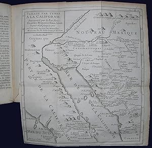
Volume 7 only [of 26]. 12mo., (6 ľ x 4 inches). (A bit toned and occasionally spotted throughout). Fine folding engraved map "Passage par terre a la Californie" (edges browned). Contemporary tan sheep, the spine in six compartments with five raised bands, gilt lettered with the general title in one, volume title in manuscript on a paper label in another (worn with minor loss to the extremities). Provenance: Dorothy Sloan, 12/11/2009, lot 323. Contemporary pen trials to front free endpaper; early ink library stamps to title page. Second and preferred edition, first published in 34 parts between 1702 and 1776. WITH "KINO'S REVOLUTIONARY MAP" (Burrus). The seventh volume (as here) of this series is one of four that deal with the Americas, and contains the immensely important map of California by Eusebio Francisco Kino (1645-1711). The map is misbound here, as it usually appears in volume 8. A Jesuit priest from what is now northern Italy, Kino set out to determine whether California was an island (as was widely thought at the time) or a peninsula. He looked at this question from a pragmatic, rather than academic, point of view, and figured it could be solved once and for all by scientific exploration. As Dorothy Sloan notes, the main impetus for Kino's curiosity was financial. The cost of transporting cattle and grain across the Gulf of California from the mainland to the Loreto mission threatened to bankrupt them. Kino knew that a land passage would greatly reduce transportation costs, and by 1698 he had discovered one. He sent his 1701 manuscript map and treatise to Spain to the Jesuit scholar, scientist, and writer, Bartolomé Alcázar. Alcázar re-drew Kino's original map and submitted it to Charles Inselin, renowned French engraver of the finest maps of his time (see Le Gear, United States Atlases V, p. 559 & Tooley's Dictionary of Mapmakers, revised edition, Vol. II, p. 410). The Jesuits first published the map in 1705, and the map appeared in print repeatedly in Europe for decades. Kino believed his evidence was sufficient to prove beyond doubt that California was a peninsula, yet the "California as an Island" myth persisted until the next century. It is hard to overstate the importance of this map. Burrus gives six major reasons for its significance: "First, it records his rediscovery (after three-quarters of a century primacy of the insular theory of California) of the true configuration of the peninsula. Secondly, this fact is established by an eyewitness. Thirdly, the land passage is at a relatively short distance from the missions and towns already founded in northwestern Mexico. Fourthly, the location of the Colorado and Gila Rivers, their confluence, their course and several of their tributaries, are established with a precision hitherto unknown. Fifthly, the recently founded Jesuit missions in Lower California are recorded cartographically for the first time. This had particular importance in view of Píccolo's 1702 printed report of the Jesuit enterprise in Lower California; inasmuch as he did not include a map of his own, editors, on reprinting his account, regularly reproduced Kino's 1701 map to accompany it. Lastly, Kino's revolutionary map was given exceptionally wide publicity in the most popular publications at the time and also in the most scientific reviews and books. Europe's most outstanding map-makers took notice of it. At first they merely mentioned the rediscovery of the peninsularity of California, often underscoring the fact that it had been made by an eyewitness; gradually the geographic reality was recognized by more and more cartographers, geographers, and historians. The insular theory had been put on trial and before a century had passed would be condemned to prudent silence if not death" (Burrus, p. 50). Additionally, Wheat notes that "Kino's map exerted a great influence on contemporary cartography, especially after the French mapmaker, Guillaume Delisle, adopted the redoubtable missionary's. N° de ref. del artículo 72MMS223
Contactar al vendedor
Denunciar este artículo


