Descripción
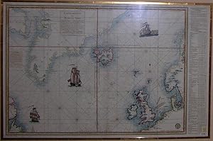
Single sheet, matted and framed (21 6/8 x 30 2/8 inches to the neat line; framed size: 33 x 45 inches). Fine engraved map of the Northern Atlantic Ocean and the North Sea, from the Coast of Labrador in the west, including most of Greenland, all of Iceland, Great Britain, and the coastline of Northern Europe from Paris in France to Saltern in Norway, the title within a frame in Greenland, with a legend centre left concerning the wind, a letterpress table in the right-hand margin giving latitudes and longitudes, the ocean decorated with three fine galleons, all with fine hand-colour in part. A beautiful map, issued by the Depot de la Marine, showing some of the area covered by Verdun de la Crenne's scientific voyage to examine and compare different methods of determining Longitude at sea. In charge of the frigate La Flore, which departed Brest in September 1771, and accompanied by Jean-Charles Borda, astronomer Alexander Pingre and painter Pierre Ozanne, Verdun de la Crenne's voyage was a laborious exercise in constantly checking marine watches and other instruments used in the contest for the Longitude prize of the Academy of Sciences, but also in examining the practical methods and calculations employed on ships in order to increase the accuracy of observations. During this voyage the location of Iceland was determined more accurately and moved 3 degrees further east. N° de ref. del artículo 72map 288
Contactar al vendedor
Denunciar este artículo