Descripci�n
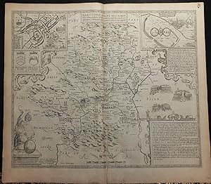
Single sheet (15 x 20 inches) Full margins showing the plate mark (slight browning to edge, ink smear margin, good margins) A rich uncolored map of Hartford Shire; taken from the Theatre of the Empire of Great Britain by famous English cartographer, John Speed. The plates used for printing these maps were engraved by Dutch mapmaker Jodocus Hondius in his Amsterdam workshop in 1610. There maps are highly sought after for their stunning accuracy, detailing, and craftsmanship. Hardford Shire is beautifully decorated with symmetrical framing and cartouches. A goddess, perhaps dedicated to modern cartography, fills the lower left corner. Hertfordshire is an English county, founded in the Norse-Saxon wars of the 9th century. The town was first recorded in the early 10th century; making it one of the oldest historic counties. "The history of Hertfordshire includes such a number of events of primary importance that it is somewhat difficult to make a selection of those most fitted to appear in the limited space available." (Lydekker) There are two plans inset within this map. First, of Hartforde. Herford is credited with being first created around 974 by King Edgar the Peaceful. The town plan is shown in great detail, providing its viewer with a letter guide to the most significant roads and buildings. This royal county town bares its shield and was mapped by John Speed himself, as indicated by the 'Scale of Pases'. The second is of Verolanium, a settled town from Roman Britain. It was sites nearby the modern central city of St Albans in Hertfordshire. Verulamium contained a forum, basilica and a theatre, much of which were damaged during two fires. Today, much of this ancient town has remained unexcavated. A framed detailed storyline of this area is provided; including short information of the Roman invasion of Britain and the origins of their patron saint, Albans. A highly desirable aspect of Speed's county maps is his inclusions of vignettes depicting famous English battles and events. This map of Hartford Shire wonderfully depicts three of them. The map boasts "three severall tymes, three mortall, and bloddy Battells of Englands civill discetions have bene fought" during the War of the Roses. The First Battle in 1455, which Richard of York and Neville the Kingmaker defeat the Lancastrians, killed their leader (Edmund Beaufort), and captured King Henry VI. The Lancastrians recaptured their King during the Second Battle in 1461. The Third Battle took place in 1471, aftermath led to victory of Lancastrians. Neville the Kingmaker was beheaded and Edward IV was ruler. This story is also provided in a border frame beneath the vignettes. The county maps found in the Theatre of the Empire of Great Britaine were the first consistent attempt to show territorial divisions, but it was mainly Speed's town plans that were the major innovation and probably his greatest contribution to British cartography. Together, they formed the first printed collection of town plans of the British Isles and, for at least 50 of the 73 included in the Theatre, it was the first time these towns had been mapped. While being the first English atlas of the British Isles, Speed's Atlas was also one of the first attempts to accurately survey Ireland and to incorporate a comprehensive list of their town plans into the maps. The 1676 edition of Speed's atlas never came with original color. The examples of this map of Hartford Shire should always be uncolored and never colored. Born in Cheshire, John Speed developed his interest in maps in the 1580s, after moving to London to pursue his passions outside of tailoring. He there joined the Society of Antiquaries, where his enthusiasm for cartography won him the attention of William Camden, Robert Cotton, and Sir Fulke Greville. By working with these figures, Speed was able to do a large amount of research for his own work. In 1596, Greville bequeathed Speed with an unlimited allowance to research, and then later write, the. N� de ref. del art�culo 72NZ33
Contactar al vendedor
Denunciar este art�culo

