Descripci�n
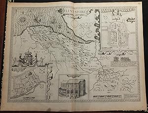
Single sheet (15 x 20 inches) Full margins showing the plate mark (slight browning to edge, crease centerfold). A superb uncolored map of Flintshire, taken from John Speed's famous Theatre of the Empire of Great Britaine. Engraved on copper plates in Amsterdam by renowned Jodocus Hondius, this is one of the most decorative maps of the county. Hondius makes excellent use of space in his engravings of the county; filling any blank spaces of the sea with sea monsters, full mast ships, and an elegant compass rose. The map is embellished with three insets; two of which are the town plans of Flint and of Saint Asaph. It is noteworthy to mention that these two plans were mapped by Speed himself, as indicated by the 'Scale of Pases'. The third inset is an enlarged illustration of St. Winefride's Well. The building gets its name from the healing waters have been said to cause miraculous cures. The legend of Saint Winifred tells how, in AD 660, Caradoc, the son of a local prince, severed the head of the young Winifred after she spurned his advances. A spring rose from the ground at the spot where her head fell and she was later restored to life by her uncle, Saint Beuno. It is claimes to be the oldest continually visited pilgrimage sites. A highly desirable element of Speed's maps is his depiction of important events of British history in vignettes. Here we can see a moment of action during the end of Richard II's reign as he is betrayed into the hands of Henry Bullingbrook. It is dated as '1400 Febr. 13', marking the king's death. The county maps found in the Theatre of the Empire of Great Britaine were the first consistent attempt to show territorial divisions, but it was mainly Speed's town plans that were the major innovation and probably his greatest contribution to British cartography. Together, they formed the first printed collection of town plans of the British Isles and, for at least 50 of the 73 included in the Theatre, it was the first time these towns had been mapped. While being the first English atlas of the British Isles, Speed's Atlas was also one of the first attempts to accurately survey Ireland and to incorporate a comprehensive list of their town plans into the maps. The 1676 edition of Speed's atlas never came with original color. The examples of this map of the Flintshire should always be uncolored and never colored. Born in Cheshire, John Speed developed his interest in maps in the 1580s, after moving to London to pursue his passions outside of tailoring. He there joined the Society of Antiquaries, where his enthusiasm for cartography won him the attention of William Camden, Robert Cotton, and Sir Fulke Greville. By working with these figures, Speed was able to do a large amount of research for his own work. In 1596, Greville bequeathed Speed with an unlimited allowance to research, and then later write, the Historie of Great Britaine. It was during this project which Speed had the encouragement to add a cartographic supplement to the work - what we today know as his most famous atlas. After being first published in 1611-1612, the 'Theatre of Great Britain' dominated the seventeenth-century English map market, going through many reprints and editions. Thanks to the Atlas' success, Speed earned the title of England's most well-known Stuart period cartographer and his work became the blueprint for folio atlases until the mid-18th century. Historically, Speed is also noted for placing England into the mainstream of map publishing, which had been dominated by the Dutch since the late sixteenth century. This map of Flintshire is an excellent part of the Theatre of the Empire of Great Britaine, and would be an outstanding addition to all map collections. For more information on this map, or a warm welcome to see other maps and books of our collection at 72nd Street NYC, please contact Natalie Zadrozna. N� de ref. del art�culo 72NZ20
Contactar al vendedor
Denunciar este art�culo


