Descripci�n
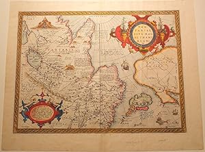
Single sheet (16 4/8 x 21 2/8 inches, full margins showing the platemark). Latin text on verso. Fine engraved map of Russia, Tartary and Japan, the title and legend within fine mannerist strapwork cartouches, the ocean decorated with galleons and a flying fish, with fine hand-colour in full. Each succeeding decade following the first New World discoveries created its own revolution of knowledge, but a watershed in the growth and illustration of geographical information was the atlas published in 1570 by Abraham Ortelius, a businessman native to Antwerp. The Theatrum Orbis Terrarum was the first atlas in the modern sense of the word, as Ortelius compiled the best existing maps, re-engraved them on a standardized format, and included them with text in one volume. This was a landmark innovation, and the Theatrum was arguably the first printed production to have a major impact on the world perspective of contemporary Europeans. Despite their relationship as competitors, Ortelius and his fellow cartographer Gerard Mercator were close friends, and together they represented the major proponents of the most celebrated period in the history of early-modern mapmaking. Ortelius's maps are rightly considered among the most beautiful ever produced, and the seamless combination of science and art is nowhere more visible than in his landmark map of Tartary. Although the element that first strikes a viewer is the high visual appeal of the brightly colored and finely engraved map, it was in fact an extremely sophisticated summary of the most advanced geographical knowledge of Ortelius's time. Ortelius had gathered maps by the best existing contemporary cartographers, including Mercator, Giacomo Gastaldi, and Olaus Magnus, in order to assess the most recent strides in delineating the shape of the continent. As a result of his discerning judgment in sorting geographical fact from geographical fiction, this map was ultimately one of the most accurate made available to late 16th-century Europeans. The Kingdom of the Great Khan. Whilst much of the nomenclature is derived from Marco Polo, this is one of the first printed maps to attempt to define the relationship between the Continental landmasses of Asia and America in the North Pacific. Shows Eastern Asia beyond the Caucasus with its Eastern coastline including much of Polo's China including the fabled city of Quinzay. Japan appears center right in one of half a dozen outlines used by Ortelius for the archipelago in the Theatrum. Honshu and Shikoku are increasingly well defined, with the indented coastline of Kyushu shown as a number of smaller Islands and with the Ryukyus and Formosa to the south. To the north are the fabled Straits of Anian, first identified by Gastaldi in 1561 and fortuitously corresponding quite closely with the present-day Bering Strait and still providing the prospect of a northeast passage via Arctic Russia. The Northwest coast of America is shown with the Baja Gulf and peninsula, the name California being employed for perhaps the first time on a printed map at its southern tip. Fine example of this popular and influential map. Accompanying the advanced geographical knowledge that the map presented is an amazing wealth of visual detail. The maps of Ortelius boast examples of the most beautiful Renaissance strapwork ever engraved, visible in the decorative title cartouche and the dedication, which is crowned with two nude allegorical figures. Rightly celebrated for unequalled beauty as much as for outstanding discovery, this map represents a monumental moment in the history of mapping. REFERENCES: Van den Broecke 163. N� de ref. del art�culo 72map415
Contactar al vendedor
Denunciar este art�culo
