Descripción
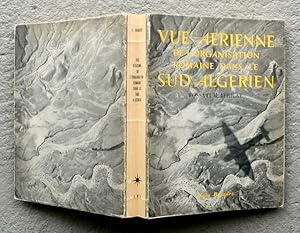
4° (27 x 20.8 x 3.5 cm). X, 369+1 SS., 4 Bll. Ca. 275 s/w-Tafeln u. Abbildungen in Tiefdruck (etliche Tafeln mit semi-transparenten Plan-Auflageblättern / quelques planches avec des croquis sur papier calque), einige Kartenskizzen i. Text, 2 gr. Faltkarten i. Anhang. Druck a. (wohl holzfreies) Mattpapier. OFranz.-Brosch. Edition originale / Erste Ausgabe. Leichte Alters u. Gebrauchsspuren / peu de traces d'age et d'usage. Gesamthaft gutes Exemplar. - - BNF no FRBNF41605509; sudoc no 01889447X - Parallelausgabe u.d.T.: Fossatum Africae : recherches aériennes sur l'organisation des confins sahariens à l'époque romaine (BNF no. FRBNF37314322; sudoc no 071688765) - 'Cet ouvrage [.] a été tiré à 3500 exemplaires, dont 2000, numérotés de 1 à 2000, ont été reservés au gouvernement général de l'Algérie' (Kolophon) - Cartes pliantes / Faltkarten (sujet/cadre 52.5 x 58.5 cm) : Carte-schéma des confins Numido-Maurétaniens, 1 et 2 - "Il ne s'agissait plus [.] de rechercher du haut des airs des vestiges encore inconnus, de les photographier à moyenne ou basse altitude, de les situer approximativement sur une carte souvent incomplète ou schématique, mais bien de prendre à haute altitude, cette fois, des photographies de vastes étendues de terrain, puis d'en examiner attentivement et à loisir les moindres détails, d'en faire jaillir les plus petits indices, de restituer en somme, non pas l'aspect géographique d'une contrée, mais son aspect archéologique, d'y découvrir, non pas les détails naturels, physiques, mais toutes les traces laissées par le passage de l'homme, le travail de l'homme, la présence de l'homme." (etc.; p. VIII) - MATIÈRES : 1. Recherches aériennes modernes sur le 'Limes' d'Afrique, 2. Le 'Fossatum Africae', 3. Les travaux d'hydraulique, la colonisation et la zone agricole du 'Limes', 4. Bourgs, stations et 'castella' découverts ou restitués exactement par recherches aériennes, 5. Le résau routier - Avec Index (pp. 363-368), et Table / légendes des illustrations (4 fll.) -- "Thought to measure 750 kilometers or more, the linear defensive structure known as Fossatum Africae was built during the rule of the Roman Empire as a measure to both defend and control the southern borders of its interests in North Africa. The four preserved sections of this historic structure are found in Algeria and neighboring Tunisia, remaining as a reminder of a time in history when the Roman Empire appeared to be unstoppable in its conquests. [.] Based primarily on the similarities between the Fossarum [sic] Africae and Britain's Hadrian Wall, French pioneer of aerial archeology, Jean Lucien Baradez (1895-1969), was of the opinion that the construction most likely started after Emperor Hadrian visited Africa in 122. His aerial photographs of the archeological sites remain the most comprehensive record of this historical structure. The Fossatum Africae consists primarily of ditches with earth embankments on either side, with some sections including dry stone walls on top of the embankments. [.] Near the Roman fort and camp located at Gemellae on the edge of the Sahara Desert in Algeria, excavations have revealed that the ditch depth is between two and three meters [.]. There are watchtowers and forts at regular intervals along Fossatum Africae. Similar structures have been found in other North African regions, including the fossatum found at Bou Regreg in Morocco." (algeria com/blog/fossatum-africae, online) - "The lasting achievement of Colonel Jean Baradez was the recognition of the roman frontier system in Algeria [.]. His publication of the primary material, mostly from his high altitude air-photographic work, forms a source book from which others are still producing fresh evidence for the detailed development of the African border. Baradez's limited excavations on the 'Fossatum' and the fort at Gemellae produced evidence for both being Hadrianic in origin." (Britannia, Vol. 11, London 1980, p. 323). -- Jean Lucien Baradez (Nancy 1895-1969 Cha. N° de ref. del artículo LR032331
Contactar al vendedor
Denunciar este artículo
![]()


