Descripción
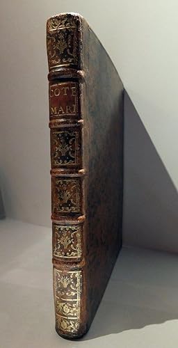
LE ROUGE, George Louis (1722 - 1778). Recueil des Cotes Maritimes de France Sur quatre Lieues de large environs En 50 Feuilles Tirez des meilleures Cartes Gravees et Manuscrittes. A Paris: Rue des Grands Augustins vis a vis Le Panier Fleury, 1757. 4to., (10 x 8 2/8 inches). Double-page engraved title-page. Fine folding engraved map "Carte Generale des Cotes de France,.", and 50 double-page maps of the French coastline. Contemporary French mottled calf, the spine in six compartments with five raised bands, citron morocco lettering-piece in one, the others decorated with fine gilt tools. Provenance: Ex-Libris Jean R. Perrette, his sale, Christie's New York, 5th April 2016, lot 76 First edition of this important atlas of the French coastline. Le Rouge was a French military engineer, hydrographer and cartographer, who eventually succeeded to the position of Ingénieur Géographe du Roi (Geographical Engineer) to King Louis XV. He published the French editions of many important American maps from the 1740's, the most famous of which, with Benjamin Franklin, a French edition of the Folger-Franklin hydrographic chart of the Gulf Stream. His most important atlas is the "Atlas Américain Septentrional", which includes a general map of North and South America, a rendition of John Mitchell's famous map of America, maps of Quebec, New England, New York, Pennsylvania, and the south-eastern states, Martinque and Guadeloupe. At the time Le Rouge published this detailed and elegant atlas of the French coastline, France was embroiled in the Seven Years War (1756 1763), the last major conflict before the French Revolution to involve all the great powers of Europe, and therefore this atlas would have been vital to France's defense strategy. Broadly speaking France, Austria, Saxony, Sweden, and Russia were aligned on one side against Prussia, Hanover, and Great Britain on the other, but the war also involved conflict over the colonies of Great Britain and France, mostly for control of North America (the French and Indian War of 1754 1763) and India. Phillips Atlases 5998; Tooley, p. 44. N° de ref. del artículo 72lib1473
Contactar al vendedor
Denunciar este artículo
![]()


