Descripción
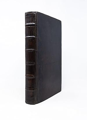
First Latin edition. Leiden: Elzevir, 1633. Folio in 6s (13 1/4" x 8 1/2", 215mm x 339mm). [Full collation available.] With 14 engraved double-page maps and 68 in-text woodcut illustrations. Bound in dark calf (re-backed). On the spine, six raised bands. Blind roll to the edges of the boards. Re-backed, with reinforcement to the fore-corners. Evenly tanned throughout, with some passages of moderate tanning. Foxed, with some staining and offsetting. Worm-hole to the fore-margin of Xx5-rear paste-down (bifurcating at Eee4), not affecting the text. Ink initials ("YO" -- a price code?) and shelfmark to the front paste-down. Armorial bookplate of the Calwich Library to the front paste-down. Ink letter to the half-title ("hs."?). Ink booksellers' codes to the rear paste-down. Johannes de Laet (1581-1649), was born in Antwerp to cloth merchant Hans de Laet. In 1584, upon the invasion of Antwerp by Spanish troops, his family fled to the Northern Netherlands and settled in Amsterdam. At the University of Leiden, he studied philosophy and theology, matriculating in 1597. His worldly interests led him to London in 1603, where he cleverly invested in Dutch land reclamation projection and overseas trade. His success in his field led him to become one of the founding directors of the Dutch West India Company- a position he held from 1620 until death. De Laet first published his account of the New World as Nieuwe Wereldt ofte Beschrijvinghe van West-Indien. (Leiden, 1625). This Latin edition, probably translated by de Laet himself, is one of the most important seventeenth-century New World histories and texts concerning early knowledge of the Americas. The "Nova Anglia" map, showing the coast and inland areas from Nova Scotia to North Carolina, is the first printed map to mention the name Manhattan, here spelled "Manbattes." "It is also the earliest to use the Dutch names of Noordt Rivier and Zuyd Rivier, for the Hudson and Delaware Rivers respectively, as well as the Indian Massachusets, for the new English colony . [the 'Nova Francia' map] is one of the foundation maps of Canada" (Streeter). It is "one of the most famous contemporary descriptions of the natural history of the New World. The work was highly praised a century later by Charlevoix, attesting to its accuracy [.] Winsor referred to Laet's book as the standard seventeenth-century work on New Netherland" (ibid.). The fourteen double-page maps are the work of Hessel Gerritsz, a Dutch engraver who was appointed official cartographer of both Dutch India Companies (over Blaeu). Calwich Abbey, (previously Calwich Priory) was an English estate near Ellastone, Staffordshire. Built circa 1130 as a satellite cell of Kenilworth Priory, it became an independent estate in 1349 under the hands of the Fleetwood family. Bernard Granville (1699-1775) purchased the estate from them and there amassed a sizeable library. The estate hosted visits by Erasmus Darwin, Handel, Anna Seward, and Jean-Jacques Rousseau. Alden & Landis 633/65; Borba de Moraes I.451; Burden 229-232; Cumming Southeast 34; Phillips 1149; Rodrigues, 1352; Sabin 38557; Schwartz & Ehrenberg, p. 105; Streeter sale 37; Willems 382. Catalogued by Sophie Fyfe. N° de ref. del artículo SJF0001
Contactar al vendedor
Denunciar este artículo
![]()


