Descripción
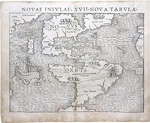
Single sheet (12 x 15 inches, full margins). Fine woodcut map of North and South America, stretching from Greenland down the coast of Newfoundland to Florida and the Caribbean, with "Cuba" distinctly labeled, and as far south as the Strait of Magellan, the map includes corners of Asia, Europe and Africa, the sea decorated with a large ship. THE FIRST MAP TO SHOW NORTH AND SOUTH AMERICA AS SEPARATE ENTITIES First edition, first issue with "Temistitan" in North American, "Atlatica" in South America, and "novvus Orbis" in North and South America, published in Munster's "Cosmographiae Universalis Lib. VI.", Basel, 1540. In 1540 Sebastian Munster, who was to become one of the most influential cartographers of the sixteenth century, published an important edition of Ptolemy's Geography, based on the Latin translation of Willibard Pirckheimer, that included for the first time a set of continental maps. Among them was this map of the New World -- the earliest separate map of the Americas. By showing North and South America connected to each other but separate from any other land mass, Munster's map emphasized the concept of the New World as a geographical entity wholly distinct from Europe and Asia. It was Munster's view of America which held sway in the European consciousness for thirty years or so, until publication of Abraham Ortelius's map in 1570. Munster's map portrays North America on the eve of Spanish exploration of the western interior. While the coastline from Newfoundland to Florida and the Gulf Coast is recognizable if distorted, the interior of North America has been left blank apart from conventional symbols representing mountains and forests. The outline of South America is based on information obtained from Ferdinand Magellan's voyage, which is symbolized by his ship pictured in the Pacific Ocean. The Portuguese flag is shown flying over the South Atlantic and the Spanish one over her possessions in the Caribbean. The Yucatan is misconstrued as an island, and a large lake near "Temistitan" (Mexico City) is depicted emptying into the Gulf of Mexico. Munster studied Hebrew at Heidelberg and was a scholar of geography. He was one of the first to create space for the insertion of place-names in metal type within the woodblocks used to print his maps -- a major innovation in printing image and text together, which was one of the greatest challenges facing map publishers in the early days of printing. When M nster included this map in a second publication, his great Cosmographia Universalis (first published 1544), he introduced his concept of the New World to an international public. The book, ultimately translated into five languages and published in forty different editions, proved to be one of the most influential works dealing with geography in sixteenth century, and Munster's map became the most widely circulated contemporary delineation of the New World. Seymour I. Schwartz & Ralph E. Ehrenberg, The Mapping of America (New York, 1980), 45; Philip D. Burden, The Mapping of North America: A List of Printed Maps 1511-1670 (Rickmansworth, 1996), 15-17. N° de ref. del artículo 72map261
Contactar al vendedor
Denunciar este artículo
![]()
