Descripción
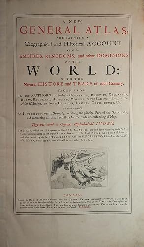
Folio (21 x 13 inches). Letterpress title-page printed in red and black with engraved vignette, list of subscribers. 13 engraved plates showing the arms of the subscribers, 34 double-page or folding engraved maps and plates, the maps with contemporary colour in outline, plans of London, Amsterdam and Rome uncoloured (Maps of Germany, France, and Spain with early repairs to verso and with top edges partially renewed). 19th-century half crimson morocco, marbled boards, gilt (rebacked preserving the original spine). Provenance: with the engraved armorial bookplate of Richard Griffin [formerly Richard Aldworth Neville], second Baron Braybrooke (1750-1825), dated 1798 the date he succeeded to the Braybrooke title, on the front paste-down. "THE MOST ELEGANT ENGLISH ATLAS OF ALL TIME" (Worms) First edition. Of the maps in the "New General Atlas", ten are apparently new plates (Europe; Moscovy; Amsterdam; France; Sicily; England; Ireland; India; Africa; Louisiana); two originated with Morden (English Empire in America; Golden Islands & Darien, the latter engraved by Moll), the first map of France also possibly, eight from Browne's stock (Denmark; Scandinavia; Spain; Rome; Bernard Randolph's Greece; Virginia; West Indies and Scotland, this latter commenced by Morden and completed by Browne), and possibly also the Spanish Netherlands, Switzerland and Savoy. Of the maps of uncertain attribution five are engraved by John Harris, who worked both for Morden and Browne (Poland; Italy; Savoy; Hungary; America), and one by Samuel Parker (London), and eight without any attribution at all (World; Germany; United Provinces; Spanish Netherlands; France; Switzerland; Asia; Turkey). Including many important maps relating to America: "New Map of the World"; "Virginia, Maryland, and the improved parts of Pennsylvania & New Jersey"; "The English Empire in the Ocean of America or West Indies"; "Louisiana and of the River Mississipi"; and the "Isthmus of Darien in America". Bookseller, publisher and maker of maps and globes, Senex was "long concerned in the production of maps and atlases. Between 1707 and 1711 he worked with Price (and later Maxwell) on a large atlas series, issuing in 1707 broadside 'Proposals for a new sett of correct mapps' advertising the partners as 'Geographers to the Queen' and promising work that 'shall in correctness, and all other particulars, far exceed any yet done'. Senex and Price subsequently went their separate ways but Senex at length produced (with Maxwell) an augmented version of these maps as "The English Atlas" (1714), the bulk of the work engraved by himself. His portable version of the road maps of John Ogilby, published as "An Actual Survey of All the Principal Roads of England and Wales" in 1719, was a popular success, staying in print for many years, while his "A New General Atlas" (1721) remains the most elegant English world atlas of the time. "The Atlas maritimus & commercialis" (1728), a work to which Halley lent his assistance and the text for which is said to have been written by Defoe, featured maps drawn on a new 'globular' projection patented in 1721, which Senex had himself devised in association with John Harris and Henry Wilson. NMM 3:434; Phillips Atlases 563; Sabin 79124; Shirley, British Library T.SEN-2a. Catalogued by Kate Hunter. N° de ref. del artículo 002555
Contactar al vendedor
Denunciar este artículo
Detalles bibliográficos
Título: A New General Atlas, containing a ...
Editorial: London: Daniel Browne, Thomas Taylor, John Darby, John Senex and others, 1721.
Encuadernación: Encuadernación de tapa dura
Edición: 1ª Edición
![]()


