Descripción
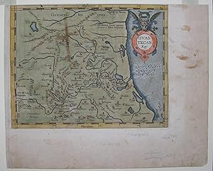
Single sheet, (9 x 11 ¼ inches). Fine engraved map of La Huasteca, with original hand color in full, surrounded by a border of yellow wash, the title within a circular cartouche decorated with a bull's head (some oxidation as expected, the margins a bit browned and spotted). First Spanish edition. A BEAUTIFULLY HAND-COLORED engraved map of the Huasteca region of Mexico, from the 1588 Spanish edition of Ortelius's Theatrum Orbis Terrarum, with Spanish text on the verso. La Huasteca is the Mexican region located along the Gulf of Mexico, including parts of the states of Tamaulipas, Veracruz, Puebla, Hidalgo, San Luis Potosí, Querétaro, and Guanajuato. "The map of the Guasteca bears neither date nor author. Because its reckoning of longitude paralleled that of the Culiacan depiction, using Toledo as a base point, Brandmair conjectured that perhaps the two were by the same hand. Even so, it is still unknown and anonymous. "The area is treated in relatively fine detail, from about Tuxpan northward to an exaggerated version of the Rio de las Palmas, close to the Tropic of Cancer. Little attempt seems to have been made to Latinize the native place-names. Again, the text is brief: 'This also is a region of North America and part of New Spain. Along its seacoasts and on its river banks they live on an abundance of fish, but inland on a grain they call maize. As a people they are civilized enough in other ways. The Spaniards have established two settlements, the one called Panuco, named for its river, and the other Santiago of the Valleys. Near a town called Tamatao, not far from Panuco, stands a hill on which are two fountains, the one discharging black pitch, the other red, scalding hot'" (H. F. Cline, "The Ortelius Maps of New Spain, 1579, and related contemporary materials, 1560-1610" in Imago Mundi XVI, p. 104). Ort15c. N° de ref. del artículo 72MMS294
Contactar al vendedor
Denunciar este artículo
![]()
