Descripción
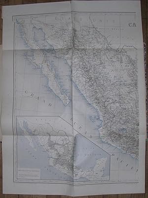
Atlas volume only. Folio (15 4/8 x 12 4/8 inches). 5 lithograph maps including 3 folding. Contemporary French red morocco backed marbled paper boards, green paper corners (extremities a bit rubbed). First edition of this RARE ATLAS, including the even rarer offprint "Notice." explaining the genesis and importance of the large Mexico map. The Atlas consists of the following maps: "Combat des Cumbres (28 Avril 1862) Combat de la Barranca-Seca (18 Mai 1862)". Uncolored lithograph. Overall sheet size: (8 x 9 5/8 inches) "Environs d'Orizaba". Uncolored lithograph. Overall sheet size: (9 5/8 x 7 2/8 inches) "Plan de Puebla et des environs pour servir a l'intelligence du combat du 5 Mai 1862 livrée par le Général de Lorencez sur les hauteurs de Guadalupe, et des opérations du siège dirigé par le Gal. Forey (du 16 Mars au 18 Mai 1863)", [with 2 insets]: [1] Combat de Sn. Lorenzo (8 Mai 1863); [2] Détails du Cadre de Santa-Ines (Attaque du 25 Avril 1863).Uncolored lithograph. Overall sheet size: (14 x 23 5/8 inches) "Plan d'Oajaca". Uncolored lithograph. Overall sheet size: (15 3/8 x 9 5/8 inches) (insect damage to upper and lower edges, not affecting the image) And the important "Carte du Mexique dressée au dépôt de la guerre Par M. Niox, Capitaine d'État Majeur. D'après les levés des officiers du corps expéditionaire et les renseignements recueillis par le Bureau Topographique". Paris, 1873 [inset] "Carte des divisions politiques". Chromolithograph, with brown land forms and blue water. 2 folding maps. Neat line to neat line: (27 4/8 x 41 inches) (one or two short separations, and some minor insect damage, at folds). In the "Notice" [NOT PRESENT HERE], Niox discusses the making of this map, its improvements over previous maps, and the general geography of Mexico. He says that the general map was drawn up for use of the French troops protecting Maximilian in their actions against the Mexicans, 1861-1867. This map embodies the best French reconnaissance of the Intervention in Mexico, upon which the campaign depended. Niox remarks that at the onset of the invasion, French cartographic materials on Mexico were negligible and of little military use, consisting of only a few general sources, primarily the work of García Cubas. As the French army advanced through Mexico, however, officers scoured such places as municipal offices and area haciendas for maps, which they then copied and collated with other sources. The collection at the Sociedad de Geografía at Mexico City was a gold mine, of course, although it hardly had a collection that covered the whole country in detail, Niox remarks. Other maps and measurements were made in the field on the fly by soldiers using what crude instruments they had. Thus is explained how this important map was built up bit by bit, area by area, until it reached its present status. Of particular interest in the last section of the pamphlet are Niox's comments, both negative and positive, on the maps he consulted. He praises García Cubas' atlas of Mexico as the best hitherto available, but claims his own map shows considerable improvement ("progrès sérieux"). Judging from the list presented of the map collection at the Dépôt de la Guerre after the war (pp. 7-8), France was hardly deficient in Mexican maps at the end and probably had the best such collection in Europe. Niox (1841-1921), head of the topographic corps of the French Expeditionary Army, later commanded the French army's Topographical Corps, supervising map construction during World War I. He was a prolific writer on geographical and military subjects. Palau 191775. Catalogued by Kate Hunter. N° de ref. del artículo 72lib1203
Contactar al vendedor
Denunciar este artículo
![]()

