Descripción
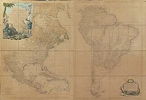
Fine folding engraved wall map of North and South America (29 ½ x 43 ¼ inches). Laid down on cartographic linen in 24 sections, with original hand color in outline, with an extremely fine hand-colored decorative cartouche upper left and additional title cartouche lower right (evenly browned, one or two pinholes, slight wear at folds). ?First edition. Map of North and South America, issued both together and individually. EXTREMELY RARE wall map showing both North and South America, with two FINE historiated cartouches. The EXQUISITELY COLORED cartouche upper left ("Amerique Septentrionale") is surrounded by allegorical figures, with Mercury and three female figures representing France (decorated with fleurs-de-lis), Spain (holding a coat of arms), and the newly formed United States (holding aloft a liberty cap on a staff). Mercury (with his winged helmut) stands upon a rock where a ship is setting anchor. The simpler cartouche lower right of rococo plastermark and foliage ("Amerique Meridionale") depicts Neptune pouring water from an urn, symbolizing rivers flowing from the sea, with a ship in the background and shells, sand, and seaweed in the foreground. "Amérique Septentrionale" shows Spanish raids in nice detail, and a trace of the Longue River is still shown in the Upper Midwest, here called the Grande Riviere. "Amérique méridionale" is largely based on d'Anville's 3-sheet map of 1748. This map shows highly developed river systems, but only rudimentary marking of mountain ranges. There are occasional geographical and historical notes, as well as numerous designations of Indian tribal and placenames. It is shown in irregular stereographic projection, with Ferro as prime meridian. Moithey was cartographer to the king. Sellers & Van Ee 196. Lowery 666. N° de ref. del artículo 72MMS395
Contactar al vendedor
Denunciar este artículo
![]()


