Descripción
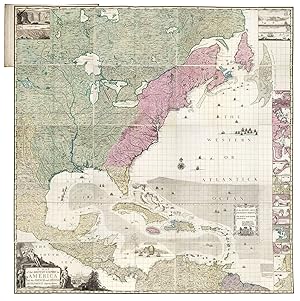
A profound statement of England's designs for dominance of the North American continent; at a time when colonial control of North America was by no means certain Large engraved wall map, with contemporary hand-colour in full, engraved on 20 printed mapsheets, 15 double-page maps and five single-page maps (the single-page maps comprise bird's eye views and harbour plans which appear on the right side of the map, from top to bottom, with 20 of the 22 views and plans appearing on these five sheets, the last two views appear on sheet 1, in the upper left corner of the map), plate 10 in Pritchard State 3, plate 20 in Pritchard State 4; with two contents leaves: "The Contents of Mr. Popple's Map of America", mounted on front pastedown, and "The Contents of each sheet of the twenty plates of Mr. Popple's Map of America", mounted on conjugate of the keymap; contemporary marbled paper boards, rebacked in calf to style. A magnificent example of Popple's twenty-sheet 'Map of the British Empire in America', with superb vibrant original hand-colour in full. One of the two most important maps of North America published in the eighteenth century on a grand scale: along with John Mitchell's 'Map of the British & French Dominions in North America', Popple's map was a profound statement of England's designs for dominance of the North American continent; at a time when colonial control of North America was by no means certain. Popple's map is the first large scale printed map to show, and name, the thirteen British colonies. Nearly eight feet square when joined, the map shows the extent, not just of the British, but also the French, and Spanish colonial possessions of North and Central America, and the West Indies. "Little is known of Henry Popple, except that he came from a family whose members had served the Board of Trade and Plantations for three generations, a connection that must have been a factor in his undertaking the map, his only known cartographic work" (McCorkle). His father and grandfather both served as secretary to the board. When his father resigned, Henry's brother, Alured, inherited the post. Henry was offered a clerkship in 1727. "Finding that position unprofitable, he resigned to work as a private financial agent for the West Indian governors and some British regiments. In that capacity he appeared before the commissioners on numerous occasions" (Pritchard & Taliaferro). Alured eventually accepted the post of governor of Bermuda, in which post he was succeeded by another brother, William. This was at a period when boundary disputes among both the colonists, and with the French, began to accelerate the need for detailed maps of North America. In 1730 the Board began requesting maps of the entirety of the provinces and contiguous regions. At the time of its publication, "France claimed not only Canada, but also territories drained by the Mississippi and its tributaries - in practical terms, an area of half a continent" (Goss). Popple's large format up-to-date map, produced under the auspices of the Lord Commissioners of Trade and Plantations, provides a clear illustration of how to better understand and demarcate all the rival claims. On close examination, an engraved dashed line identifying the boundaries of the colonial powers can be seen. However, to facilitate a clearer visual depiction of these boundaries, Popple devised a colour scheme for depicting the claims of the various colonial powers. As noted by Babinski: "The typical coloring [sic] of fully colored copies. is described best by a contemporary manuscript legend on the end-paper affixing the Key map to the binding in the King George III copy at the British Library: Green - Indian Countrys. Red - English. Yellow - Spanish. Blue - French. Purple - Dutch". The careful demarcation of the disputed areas by colour makes identification of whether a particular location was in one or another 'zone' a great deal easier. Thus, the original full-colour examples are particularl. N° de ref. del artículo 17510
Contactar al vendedor
Denunciar este artículo
![]()
