Descripción
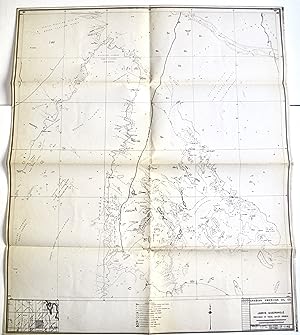
Five in-house exploration maps, various editions and dates, sized @53-58 x 64-74cm, 1:200,000 (some scales are stated incorrectly as 1:100,000 or 1:2,000,000). Four of the sheets adjoin one another in Eastern Province, with Qidam (NW), Qatif (NE), Hofuf (SE), and En Nala (SW), while Jabrin in Hasa Province sits 2 rows below En Nala. Very good with some short closed tears, pinholes, notes and marks. These are very rare survivors, with Worldcat listing just one each of Qatif (1953 at Harvard) and Hofuf (1981 at LoC). Compiled from ground and air surveys, this series gradually updated Aramco's early field maps, covering its most important sites and installations, including traditional and ancient routes and settlements. They are highly detailed, with features including power lines; roads, camel tracks; rail; villages; buildings; date gardens; wadis; sabhka; surveying features; water wells; observation wells; gas injection wells; oil wells; water injections wells; abandoned wells; suspended drilling wells; abandoned oil wells; observation water wells; observation gas wells; pipelines; cultivation; irrigation and drainage canals; intermittent streams; mines and quarries; spot heights and notes on terrain. (1) F-1142 JABRIN QUADRANGLE, 1 Jul 1940 (latest rev 29 Dec 1953), JW Thomas, GS Sheets, checked by Thomas Barger. Located in the Rub al Khali 200 miles south of Hofuf at the edge of the Jafurah desert, it marks the start of the "Road to Dhahran" at a small cluster of Arab water wells near Faraid el Idhbatiya. This road runs north via Camp Jabrin where Barger (Aramco's future President and CEO) had been based in Feb 1940 during his early desert tours. The area remains very undeveloped with isolated airstrips, numerous trig stations, and notes (eg "many slumps, this area not mapped in detail"). A fragment of track is labelled "ancient big camel trail". Similar unlabelled lines may be old caravan routes, one of which crosses El Ghazaala Airstrip. // (2) F-1226 QIDAM, Feb 1963, First Edition. This includes parts of the Fadhili and Ghawar Fields, the latter discovered by Barger and Max Steineke with the help of Bedouin guides. In 1963 Fadhili and Khurais came on stream and work started on the vast Ghawar field. // (3) F-1260 QATIF, Mar 1953 (latest rev 17 May 1981), ML Stapleton, checked by CW Philips. This includes several important installations: Abqaiq, Dammam, Ras Tanura, Al Khobar, Nejma, Safwa, and Tarut Island. Extensive development is reflected in dense infrastructure, pipelines, transmission lines etc, an "abandoned town development" near Abqaiq, the Royal Saudi Air Force Gunnery Range, and pipeline link with Bahrain. // (4) F-1160 HOFUF, May 1958 (latest rev 6 Nov 1971). Centred on the vast Al Jafurah gas field this shows the major Saudi centre of Hofuf in Hasa Oasis, Abqaiq, and part of Bahrain. Features include the Govt Railway, water supply wells, and Gunnery Range. Among the camel routes are Darb Mikhyat into Hofuf, the route from inland to the ancient port of Uqair shown on the coast, and coastal trails. // (5) F-1224 EN NALA, June 1958 (latest rev 18 Sep 1973). This includes major developments at Ain Dar and Uthmaniyah, various lines connecting Khurais, Abqaiq etc, and part of the Govt Railway. It is criss-crossed by traditional routes among them Darb Mazalij (Musaliq) which eventually reaches Riyadh, Darb Mikhyat, Darb al Arari and Darb Edh Dhaayini.
N° de ref. del artículo 4437
Contactar al vendedor
Denunciar este artículo


